156:
463:
326:, "To allow a river to flow through and thereby divide a capital would have symbolized potential disunity of the nation. One of the first tasks, therefore, in laying out the new capital was to divert the rivers. The Kamo River once flowed through what is now Horikawa Street and met the Takano River south of their present confluence. Thus, large-scale works were required to prepare the land for the capital. The city was laid with its northernmost boundary at the present confluence of the Kamo and Takano rivers (just south of today's
1635:
164:
47:
718:
1647:
919:
645:
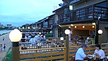
204:. The riverbanks are popular walking spots for residents and tourists. In summer, restaurants open balconies looking out to the river. There are walkways running alongside the river, and some stepping stones that cross the river. The water level of the river is usually relatively low; less than one meter in most places. During the
376:
The geographical area called
Kamigamo, around the mouth of the valley leading into the Kyoto Basin, became the home grounds of the Kamo (賀茂) clan in ancient times. From this, there arose the regional name Otagi Region Kamo Block (愛宕郡賀茂郷), and consequently the geographical name Kamo (賀茂) set down
385:
380:
From the Deai Bridge until the Iwaya Bridge north of Kyoto city it is called
Kumogahatagawa (雲が畑川) as it passes through the Kumogahata village. North of the Iwaya Bridge until its source the Kamo River is known as Ojitanigawa (祖父谷川).
388:
393:
391:
387:
386:
392:
373:(日本記略), it is referred to as 鴨川. Now, the river north of where it joins with the Takano River is usually distinguished as the 加茂川 when written in kanji, and the river south of there is distinguished as the 鴨川.
333:
The riverbanks where the Kamo River and Takano River join are known as the Tadasu River Banks (Jp., Tadasu-gawara 糺河原). At the triangular area of land here, there is the "River
Confluence" shrine of
390:
470:
In the past, the river was a crucial source of relatively pure drinking water for Kyoto residents. It also played a role in Kyo-Yuzen dyeing, a famous craft of Kyoto.
406:
When the palace at the new Heian
Capital (now Kyoto) was constructed at the end of the 8th century, the river's course was altered to flow east of the palace.
389:
424:), dice, and the water of the Kamo River. These days, however, the riverbanks are reinforced with concrete and have improved drainage systems. The merchant
655:
706:
684:
155:
314:
There is a theory that in former times the main stream of the Kamo River was along the
Horikawa river about 1 kilometre (1 mile) north of
1673:
548:
540:
508:
365:. However, other kanji applied to this name are 賀茂川 or 加茂川. The first appearance in historical documents of the kanji 賀茂川 is in the
432:
on a parallel with the Kamo River in early 17th century. Transportation was done on the canal instead of the unstable mainstream.
699:
923:
443:
at Gojō Bridge (not the present one, but presumably
Matsubara Bridge) over the river is a famous legend set in the late
800:
1651:
1076:
462:
971:
28:
473:
The river is also the source of the stone that is a glaze ingredient used in traditional
Japanese raku pottery.
1678:
1639:
692:
1051:
722:
205:
279:("Central") ward. In the vicinity of the Shijō Bridge at Shijō Street in the center of downtown Kyoto, the
275:
which flows down from the northeastern direction, and there changes direction to due south through Kyoto's
886:
484:
formed a troupe of female dancers and began performing on a makeshift stage, on the dry bed of the river.
436:
323:
1493:
649:
1028:
27:
This article is about the river through Kyoto. For dozens of other rivers and streams by this name, see
292:
535:(Kodansha International Ltd.), with text by Herbert E. Plutschow and Foreword by Donald Keene, p. 34.
452:
263:
in the same northern ward of the city, from there it bends south-east and, around the spot known as
315:
1483:
1574:
1569:
1399:
1346:
1279:
322:(now Kyoto) was established, the river was diverted to its present route. According to historian
256:
240:
1488:
448:
425:
244:
503:(Japanese encyclopedia of Kyoto), entry "Kamogawa" (鴨川; which refers from 賀茂川). Tankosha 1984.
296:
1374:
1356:
1214:
544:
536:
504:
413:
288:
276:
260:
68:
1241:
1169:
1144:
958:
853:
805:
334:
327:
220:
197:
1594:
1473:
1409:
1033:
881:
771:
280:
216:
1478:
1209:
1194:
1111:
1043:
783:
1584:
1505:
1468:
1299:
1284:
1149:
1013:
988:
983:
901:
891:
843:
838:
833:
825:
815:
766:
756:
481:
338:
284:
252:
228:
224:
141:
1667:
1612:
1564:
1559:
1500:
1414:
1324:
1294:
1261:
1236:
1124:
1101:
998:
993:
966:
906:
876:
863:
761:
304:
268:
1607:
1602:
1512:
1463:
1424:
1419:
1404:
1369:
1309:
1289:
1269:
1251:
1224:
1204:
1189:
1164:
1139:
1086:
1081:
1018:
1008:
1003:
848:
810:
790:
748:
444:
429:
300:
272:
212:
1579:
1389:
1339:
1154:
319:
17:
1364:
1184:
1159:
1119:
1066:
1023:
978:
795:
776:
369:(山城国風土記). In an entry dated the 19th day of the 6th month of 815 in the history
163:
97:
1554:
1379:
1334:
1319:
1314:
1304:
1246:
1219:
1199:
1174:
1134:
1129:
1096:
1091:
1071:
1061:
896:
871:
456:
421:
308:
147:
112:
46:
670:
657:
617:
1394:
1384:
1274:
1229:
1179:
1056:
167:
593:
Kodansha
Encyclopedia of Japan, entry for "Kamogawa." (Kodansha Ltd., 1983)
644:
736:
417:
1448:
603:
264:
248:
1536:
946:
604:"Raku Pottery · A Brief History and Guide to Raku-yaki · 2000 Cranes"
477:
440:
717:
461:
409:
383:
354:
208:, however, the walkways sometimes flood in their lower stretches.
201:
162:
154:
85:
1533:
1445:
943:
733:
688:
239:
The Kamo River has its source in the mountains in the area of
357:
compound 鴨川. The first kanji means "wild duck" and is read
377:
roots. The river name took after this geographical name.
1593:
1547:
1355:
1260:
1110:
1042:
957:
862:
824:
747:
139:
134:
126:
118:
106:
96:
91:
81:
76:
56:
39:
361:, and the second kanji means "river" and is read
185:
179:
60:
700:
8:
466:Couples sitting by the Kamo River in Summer
1544:
1530:
1456:
1442:
954:
940:
744:
730:
707:
693:
685:
476:The Kamo River is also the birthplace of
283:joins with it. At its southern part, the
271:(or "Upper Kyoto" ward), joins with the
493:
416:recited his three unmanageable things:
412:often threatened the ancient capital.
337:, which leads into the forested area,
36:
7:
1646:
918:
451:was regarded as the west end of the
397:A few scenes from Kamo River in 2022
51:Cherry blossoms along the Kamo River
25:
723:River systems and rivers of Japan
303:of Kyoto City, it joins with the
159:Restaurants overlooking the river
1645:
1634:
1633:
917:
716:
643:
349:In Japanese the river is called
130:210 km (81 sq mi)
45:
353:, officially written using the
307:, to become a tributary of the
191:
1:
924:Rivers of Hokkaido on Commons
92:Physical characteristics
801:Shiribeshi-Toshibetsu River
255:of Kyoto. Flowing into the
186:
108: • location
1695:
1674:Rivers of Kyoto Prefecture
1652:Rivers of Japan on Commons
563:, entry for Tadasu-gawara.
259:from the city area called
26:
1629:
1543:
1529:
1459:
1455:
1441:
953:
939:
915:
743:
729:
243:, around the boundary of
180:
61:
44:
1640:Rivers of Japan Category
671:34.931416°N 135.737236°E
367:Yamashiro no kuni fudoki
211:It is known for the two
622:Encyclopedia Britannica
618:"Okuni | Kabuki dancer"
572:"Kyoto Daijiten", ibid.
122:31 km (19 mi)
467:
437:Minamoto no Yoshitsune
435:The encounter between
398:
170:
160:
676:34.931416; 135.737236
652:at Wikimedia Commons
465:
396:
291:join with it, and at
166:
158:
324:Herbert E. Plutschow
1494:Sumiyoshijima River
667: /
190:, duck river – see
135:Basin features
468:
399:
241:Mount Sajikigatake
171:
161:
18:Kamo River (Kyoto)
1661:
1660:
1625:
1624:
1621:
1620:
1525:
1524:
1521:
1520:
1437:
1436:
1433:
1432:
1215:Kiso Three Rivers
935:
934:
931:
930:
648:Media related to
533:Introducing Kyoto
414:Emperor Shirakawa
394:
293:Shimomukōjima-cho
289:West Takase River
153:
152:
16:(Redirected from
1686:
1649:
1648:
1637:
1636:
1545:
1531:
1457:
1443:
955:
941:
921:
920:
806:Shiribetsu River
745:
731:
721:
720:
709:
702:
695:
686:
682:
681:
679:
678:
677:
672:
668:
665:
664:
663:
660:
647:
632:
631:
629:
628:
614:
608:
607:
600:
594:
591:
585:
579:
573:
570:
564:
558:
552:
530:
524:
518:
512:
498:
428:constructed the
420:(armed monks of
395:
335:Shimogamo Shrine
328:Imadegawa Street
251:village in the
221:Shimogamo Shrine
198:Kyoto Prefecture
195:
189:
183:
182:
144:
72:
64:
63:
49:
37:
21:
1694:
1693:
1689:
1688:
1687:
1685:
1684:
1683:
1679:Rivers of Japan
1664:
1663:
1662:
1657:
1617:
1595:Yaeyama Islands
1589:
1539:
1517:
1474:Shinmachi River
1451:
1429:
1410:Takahashi River
1351:
1256:
1106:
1038:
1034:Yoneshiro River
949:
927:
911:
882:Mitsuishi River
858:
820:
772:Makomanai River
739:
725:
715:
713:
675:
673:
669:
666:
661:
658:
656:
654:
653:
641:
636:
635:
626:
624:
616:
615:
611:
602:
601:
597:
592:
588:
580:
576:
571:
567:
559:
555:
531:
527:
519:
515:
499:
495:
490:
426:Suminokura Ryōi
404:
384:
347:
318:, and when the
281:Shirakawa River
237:
223:and the shared
217:Kamigamo Shrine
215:on its course:
177:
140:
109:
66:
52:
35:
32:
23:
22:
15:
12:
11:
5:
1692:
1690:
1682:
1681:
1676:
1666:
1665:
1659:
1658:
1656:
1655:
1643:
1630:
1627:
1626:
1623:
1622:
1619:
1618:
1616:
1615:
1610:
1605:
1599:
1597:
1591:
1590:
1588:
1587:
1582:
1577:
1572:
1567:
1562:
1557:
1551:
1549:
1541:
1540:
1534:
1527:
1526:
1523:
1522:
1519:
1518:
1516:
1515:
1510:
1509:
1508:
1498:
1497:
1496:
1491:
1486:
1481:
1471:
1469:Shimanto River
1466:
1460:
1453:
1452:
1446:
1439:
1438:
1435:
1434:
1431:
1430:
1428:
1427:
1422:
1417:
1412:
1407:
1402:
1397:
1392:
1387:
1382:
1377:
1375:Gōnokawa River
1372:
1367:
1361:
1359:
1357:Chūgoku region
1353:
1352:
1350:
1349:
1344:
1343:
1342:
1337:
1332:
1327:
1322:
1312:
1307:
1302:
1300:Maruyama River
1297:
1292:
1287:
1285:Kinokawa River
1282:
1277:
1272:
1266:
1264:
1258:
1257:
1255:
1254:
1249:
1244:
1239:
1234:
1233:
1232:
1227:
1222:
1212:
1207:
1202:
1197:
1192:
1187:
1182:
1177:
1172:
1167:
1162:
1157:
1152:
1147:
1142:
1137:
1132:
1127:
1122:
1116:
1114:
1108:
1107:
1105:
1104:
1099:
1094:
1089:
1084:
1079:
1074:
1069:
1064:
1059:
1054:
1048:
1046:
1040:
1039:
1037:
1036:
1031:
1026:
1021:
1016:
1011:
1006:
1001:
996:
991:
989:Komagome River
986:
984:Kitakami River
981:
976:
975:
974:
963:
961:
951:
950:
944:
937:
936:
933:
932:
929:
928:
916:
913:
912:
910:
909:
904:
902:Shizunai River
899:
894:
892:Niikappu River
889:
884:
879:
874:
868:
866:
860:
859:
857:
856:
851:
846:
844:Shokotsu River
841:
839:Shibetsu River
836:
834:Abashiri River
830:
828:
826:Sea of Okhotsk
822:
821:
819:
818:
816:Zenibako River
813:
808:
803:
798:
793:
788:
787:
786:
781:
780:
779:
774:
767:Toyohira River
764:
757:Ishikari River
753:
751:
741:
740:
734:
727:
726:
714:
712:
711:
704:
697:
689:
640:
639:External links
637:
634:
633:
609:
595:
586:
582:Kyoto Daijiten
574:
565:
561:Kyoto Daijiten
553:
525:
521:Kyoto Daijiten
513:
501:Kyoto Daijiten
492:
491:
489:
486:
482:Izumo no Okuni
403:
400:
346:
343:
339:Tadasu-no-mori
285:Horikawa River
236:
233:
229:Tadasu-no-mori
225:Chinju no Mori
196:is located in
151:
150:
145:
137:
136:
132:
131:
128:
124:
123:
120:
116:
115:
110:
107:
104:
103:
100:
94:
93:
89:
88:
83:
79:
78:
74:
73:
58:
54:
53:
50:
42:
41:
34:River in Japan
33:
24:
14:
13:
10:
9:
6:
4:
3:
2:
1691:
1680:
1677:
1675:
1672:
1671:
1669:
1654:
1653:
1644:
1642:
1641:
1632:
1631:
1628:
1614:
1613:Urauchi River
1611:
1609:
1606:
1604:
1601:
1600:
1598:
1596:
1592:
1586:
1583:
1581:
1578:
1576:
1573:
1571:
1568:
1566:
1565:Kikuchi River
1563:
1561:
1560:Chikugo River
1558:
1556:
1553:
1552:
1550:
1546:
1542:
1538:
1532:
1528:
1514:
1511:
1507:
1504:
1503:
1502:
1501:Yoshino River
1499:
1495:
1492:
1490:
1487:
1485:
1482:
1480:
1477:
1476:
1475:
1472:
1470:
1467:
1465:
1462:
1461:
1458:
1454:
1450:
1444:
1440:
1426:
1423:
1421:
1418:
1416:
1415:Takatsu River
1413:
1411:
1408:
1406:
1403:
1401:
1398:
1396:
1393:
1391:
1388:
1386:
1383:
1381:
1378:
1376:
1373:
1371:
1368:
1366:
1363:
1362:
1360:
1358:
1354:
1348:
1345:
1341:
1338:
1336:
1333:
1331:
1328:
1326:
1325:Katsura River
1323:
1321:
1318:
1317:
1316:
1313:
1311:
1308:
1306:
1303:
1301:
1298:
1296:
1295:Kuzuryu River
1293:
1291:
1288:
1286:
1283:
1281:
1278:
1276:
1273:
1271:
1268:
1267:
1265:
1263:
1262:Kansai region
1259:
1253:
1250:
1248:
1245:
1243:
1240:
1238:
1237:Kushida River
1235:
1231:
1228:
1226:
1223:
1221:
1218:
1217:
1216:
1213:
1211:
1208:
1206:
1203:
1201:
1198:
1196:
1193:
1191:
1188:
1186:
1183:
1181:
1178:
1176:
1173:
1171:
1170:Kuzuryū River
1168:
1166:
1163:
1161:
1158:
1156:
1153:
1151:
1148:
1146:
1145:Jōganji River
1143:
1141:
1138:
1136:
1133:
1131:
1128:
1126:
1125:Shinano River
1123:
1121:
1118:
1117:
1115:
1113:
1109:
1103:
1102:Tsurumi River
1100:
1098:
1095:
1093:
1090:
1088:
1085:
1083:
1080:
1078:
1075:
1073:
1070:
1068:
1065:
1063:
1060:
1058:
1055:
1053:
1052:Arakawa River
1050:
1049:
1047:
1045:
1041:
1035:
1032:
1030:
1027:
1025:
1022:
1020:
1017:
1015:
1012:
1010:
1007:
1005:
1002:
1000:
999:Mabechi River
997:
995:
994:Koyoshi River
992:
990:
987:
985:
982:
980:
977:
973:
972:Arakawa River
970:
969:
968:
967:Abukuma River
965:
964:
962:
960:
959:Tōhoku region
956:
952:
948:
942:
938:
926:
925:
914:
908:
907:Tokachi River
905:
903:
900:
898:
895:
893:
890:
888:
885:
883:
880:
878:
877:Kushiro River
875:
873:
870:
869:
867:
865:
864:Pacific Ocean
861:
855:
854:Yūbetsu River
852:
850:
847:
845:
842:
840:
837:
835:
832:
831:
829:
827:
823:
817:
814:
812:
809:
807:
804:
802:
799:
797:
794:
792:
789:
785:
782:
778:
775:
773:
770:
769:
768:
765:
763:
762:Chitose River
760:
759:
758:
755:
754:
752:
750:
746:
742:
738:
732:
728:
724:
719:
710:
705:
703:
698:
696:
691:
690:
687:
683:
680:
651:
646:
638:
623:
619:
613:
610:
605:
599:
596:
590:
587:
583:
578:
575:
569:
566:
562:
557:
554:
550:
549:4-7700-1404-X
546:
542:
541:0-87011-904-4
538:
534:
529:
526:
522:
517:
514:
510:
509:4-473-00885-1
506:
502:
497:
494:
487:
485:
483:
479:
474:
471:
464:
460:
458:
454:
450:
446:
442:
438:
433:
431:
427:
423:
419:
415:
411:
407:
401:
382:
378:
374:
372:
368:
364:
360:
356:
352:
344:
342:
340:
336:
331:
329:
325:
321:
320:Heian Capital
317:
316:Misono Bridge
312:
310:
306:
305:Katsura River
302:
298:
294:
290:
286:
282:
278:
274:
270:
266:
262:
258:
254:
253:northern ward
250:
246:
242:
234:
232:
230:
227:between them
226:
222:
218:
214:
209:
207:
203:
199:
193:
188:
176:
169:
165:
157:
149:
146:
143:
138:
133:
129:
125:
121:
117:
114:
111:
105:
101:
99:
95:
90:
87:
84:
80:
75:
70:
59:
55:
48:
43:
38:
30:
19:
1650:
1638:
1608:Nakama River
1603:Kokuba River
1513:Niyodo River
1484:Tamiya River
1479:Suketō River
1464:Aibiki River
1425:Yoshii River
1420:Tenjin River
1405:Sendai River
1370:Ashida River
1329:
1310:Yamato River
1290:Kumano River
1270:Choshi River
1252:Minami River
1225:Nagara River
1210:Shōnai River
1205:Yahagi River
1195:Tenryū River
1190:Sakawa River
1165:Tedori River
1140:Kurobe River
1112:Chūbu region
1087:Sumida River
1082:Sagami River
1044:Kantō region
1029:Takase River
1019:Oirase River
1009:Natori River
1004:Mogami River
922:
849:Tokoro River
811:Teshio River
791:Koetoi River
784:Yūbari River
749:Sea of Japan
642:
625:. Retrieved
621:
612:
598:
589:
581:
577:
568:
560:
556:
532:
528:
520:
516:
500:
496:
475:
472:
469:
449:Sanjō Bridge
445:Heian period
434:
430:Takase River
408:
405:
379:
375:
371:Nihonkiryaku
370:
366:
362:
358:
350:
348:
332:
313:
301:Fushimi Ward
273:Takano River
247:village and
238:
213:Kamo Shrines
210:
206:rainy season
174:
172:
142:River system
1585:Ōyodo River
1506:Dōzan River
1365:Asahi River
1340:Dōton River
1160:Oyabe River
1150:Jinzū River
1120:Agano River
1067:Kanda River
1024:Omono River
1014:Ōhata River
979:Iwaki River
796:Rumoi River
777:Anano River
674: /
662:135°44′14″E
455:during the
257:Kyoto Basin
57:Native name
1668:Categories
1575:Mimi River
1570:Kuma River
1555:Arie River
1535:Rivers of
1489:Sako River
1447:Rivers of
1400:Saba River
1380:Hino River
1347:Yura River
1335:Kizu River
1330:Kamo River
1320:Yasu River
1315:Yodo River
1305:Muko River
1280:Kako River
1247:Kita River
1242:Miya River
1220:Kiso River
1200:Toyo River
1175:Fuji River
1135:Hime River
1130:Seki River
1097:Tone River
1092:Tama River
1077:Naka River
1072:Kuji River
1062:Fuji River
945:Rivers of
897:Saru River
872:Akan River
735:Rivers of
659:34°55′53″N
650:Kamo River
627:2019-05-05
488:References
480:. In 1603
457:Edo period
422:Enryaku-ji
345:Onomastics
309:Yodo River
245:Kumogahata
192:onomastics
175:Kamo River
148:Yodo River
127:Basin size
113:Yodo River
40:Kamo River
1580:Ōno River
1395:Oze River
1390:Ōta River
1385:Hii River
1275:Ibo River
1230:Ibi River
1180:Abe River
1155:Shō River
1057:Edo River
351:Kamo-gawa
297:Shimotoba
235:Geography
187:Kamo-gawa
168:Hiroshige
1185:Ōi River
887:Mu River
737:Hokkaido
551:(Japan).
299:part of
261:Kamigamo
77:Location
69:Japanese
29:Kamogawa
1449:Shikoku
584:, ibid.
543:(USA);
453:Tōkaidō
402:History
295:in the
277:Nakagyō
269:Kamigyō
267:in the
265:Demachi
249:Keihoku
82:Country
1548:Kyushu
1537:Kyushu
947:Honshu
547:
539:
523:(ibid)
507:
478:Kabuki
441:Benkei
410:Floods
119:Length
102:
65:
418:Sōhei
355:kanji
202:Japan
98:Mouth
86:Japan
545:ISBN
537:ISBN
505:ISBN
439:and
363:gawa
359:kamo
330:)."
287:and
219:and
173:The
1670::
620:.
459:.
447:.
341:.
311:.
231:.
200:,
184:,
181:鴨川
62:鴨川
708:e
701:t
694:v
630:.
606:.
511:.
194:)
178:(
71:)
67:(
31:.
20:)
Text is available under the Creative Commons Attribution-ShareAlike License. Additional terms may apply.