60:
265:
44:
289:
67:
277:
252:
to
Karanjgavhan distance is about 15 km. From Karanjgavhan the road to the village Kankrala is about 5 km. The cart road take a western detour from village Kankrala which leads to the temple near the fort. From the temple the fort is clearly visible. It takes about an hour to reach the fort
238:
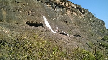
There are many rock cut water cisterns on the top of the fort as well as in the rocks near the gate. The water near the gate is potable. There are few caves near the entrance. The entrance is in dilapidated condition. There are no structures on the fort except few ruins.
247:
The village
Karanjgavhan is situated near the village Kankrala. There is a direct road from Malegaon via Vadgaon and Lendhane villages to Karanjgavhan ( distance 11 km). The other route is through the road from Zodage which is on National Highway 3.
59:
312:
345:
90:
230:
fort. Very little history is known about this fort. It was captured by the
British under Colonel Wallace in 1818.
264:
249:
203:
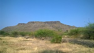
288:
215:
30:
339:
276:
34:
105:
92:
211:
43:
227:
185:
181:
173:
168:
160:
150:
142:
137:
129:
121:
84:
23:
214:that occupies two hills in the Malegaon taluka of
253:top. There are no proper steps or path ways.
8:
20:
305:
260:
66:
7:
328:. Sahyadri Prakashan. p. 278.
14:
287:
275:
263:
65:
58:
42:
226:This fort is situated south of
1:
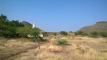
270:Temple and the fort at right
362:
207:
193:
53:
41:
28:
346:Forts in Nashik district
324:Zingaro, Young (1995).
106:20.70667°N 74.486611°E
326:Sangati sahyadricha
146:Government of India
111:20.70667; 74.486611
102: /
16:Hill Fort in India
197:
196:
353:
330:
329:
321:
315:
310:
291:
279:
267:
210:) is an ancient
209:
138:Site information
117:
116:
114:
113:
112:
107:
103:
100:
99:
98:
95:
69:
68:
62:
46:
37:
21:
361:
360:
356:
355:
354:
352:
351:
350:
336:
335:
334:
333:
323:
322:
318:
311:
307:
302:
295:
292:
283:
280:
271:
268:
259:
245:
236:
224:
216:Nashik district
153:the public
152:
110:
108:
104:
101:
96:
93:
91:
89:
88:
80:
79:
78:
77:
76:
75:
74:
70:
49:
31:Nashik district
29:
17:
12:
11:
5:
359:
357:
349:
348:
338:
337:
332:
331:
316:
304:
303:
301:
298:
297:
296:
293:
286:
284:
281:
274:
272:
269:
262:
258:
255:
244:
241:
235:
232:
223:
220:
195:
194:
191:
190:
187:
183:
182:
179:
178:
175:
171:
170:
166:
165:
162:
158:
157:
154:
148:
147:
144:
140:
139:
135:
134:
131:
127:
126:
123:
119:
118:
86:
82:
81:
72:
71:
64:
63:
57:
56:
55:
54:
51:
50:
47:
39:
38:
26:
25:
15:
13:
10:
9:
6:
4:
3:
2:
358:
347:
344:
343:
341:
327:
320:
317:
314:
313:Kankrala Fort
309:
306:
299:
290:
285:
278:
273:
266:
261:
256:
254:
251:
242:
240:
234:Places to see
233:
231:
229:
221:
219:
217:
213:
205:
201:
192:
188:
184:
180:
176:
172:
167:
163:
159:
155:
149:
145:
141:
136:
132:
128:
124:
120:
115:
87:
83:
73:Kankrala Fort
61:
52:
48:Kankrala fort
45:
40:
36:
32:
27:
24:Kankrala Fort
22:
19:
325:
319:
308:
246:
243:How to reach
237:
225:
199:
198:
169:Site history
151:Open to
97:74°29′11.8″E
18:
294:Water tanks
109: /
85:Coordinates
35:Maharashtra
300:References
186:Difficulty
94:20°42′24″N
212:hill fort
174:Materials
161:Condition
133:2476 feet
125:hill fort
340:Category
208:कंक्राळा
200:Kankrala
257:Gallery
222:History
204:Marathi
250:Zodage
189:Medium
130:Height
282:Caves
228:Galna
177:Stone
164:Ruins
143:Owner
122:Type
156:Yes
342::
218:.
206::
33:,
202:(
Text is available under the Creative Commons Attribution-ShareAlike License. Additional terms may apply.