36:
55:
602:
62:
415:, run about 50 miles (80 km) down the Muddy River to Birch Creek, then downstream to the Birch–McKinley confluence (the source of the Kantishna) and then down the Kantishna to the Tanana. The entire trip is rated Class I (easy) on the
426:
and entering the
Kantishna River along its middle reaches near Bearpaw. From there to the Tanana, the run is the same as the Lake Minchumina float. The Moose Creek segment includes Class II (medium) rapids.
632:
647:
411:
Boaters can float the
Kantishna River and some of its tributaries in canoes, folding canoes and kayaks, or inflatable canoes and kayaks. Some trips begin at
637:
622:
642:
416:
35:
130:
581:
553:
419:. Dangers include the possibility of dangerous winds on Minchumina Lake, as well as overhanging trees, stumps, and logs along the streams.
54:
392:
167:
267:
508:
154:
253:
185:
606:
388:
17:
627:
436:
461:
412:
422:
Another tributary, Moose Creek, can be floated for about 50 miles (80 km) beginning at Wonder Lake or
126:
364:
89:
335:
577:
549:
423:
517:
384:
249:
171:
150:
616:
399:
including the Denali massif. The direction of flow is generally north-northeast. The
347:
106:
487:
400:
396:
372:
351:
236:
41:
231:
376:
282:
269:
200:
187:
574:
The Alaska River Guide: Canoeing, Kayaking, and
Rafting in the Last Frontier
548:(7th ed.). Yarmouth, Maine: DeLorme. 2010. pp. 102–03 and 113–14.
576:(3rd ed.). Birmingham, Alabama: Menasha Ridge Press. pp. 165–66.
601:
510:
Dictionary of Alaska Place Names: Geological Survey
Professional Paper 567
516:. United States Government Printing Office. p. 495. Archived from
380:
116:
507:
Orth, Donald J.; United States
Geological Survey (1971) .
40:
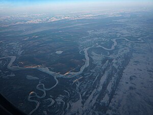
Confluence of the
Kantishna River (bottom left) with the
69:
Location of the mouth of the
Kantishna River in Alaska
341:
329:
321:
316:
308:
298:
259:
242:
230:
216:
177:
160:
145:
136:
122:
112:
102:
97:
77:
28:
81:
468:. United States Geological Survey. March 31, 1981
371:) is a 108-mile (174 km) tributary of the
502:
500:
498:
496:
8:
633:Rivers of Yukon–Koyukuk Census Area, Alaska
395:, it drains part of the north slope of the
486:Derived by entering source coordinates in
567:
565:
540:
538:
448:
417:International Scale of River Difficulty
61:
456:
454:
452:
25:
648:Rivers of Unorganized Borough, Alaska
7:
466:Geographic Names Information System
248:32 miles (51 km) northwest of
383:. Formed by the confluence of the
14:
638:Denali National Park and Preserve
393:Denali National Park and Preserve
168:Denali National Park and Preserve
623:Rivers of Denali Borough, Alaska
600:
60:
53:
34:
254:Yukon–Koyukuk Census Area
131:Yukon–Koyukuk Census Area
643:Tributaries of the Yukon River
261: • coordinates
179: • coordinates
23:River in Alaska, United States
1:
137:Physical characteristics
546:Alaska Atlas & Gazetteer
300: • elevation
218: • elevation
244: • location
162: • location
664:
15:
312:108 mi (174 km)
226:
166:near Chilchukabena Lake,
141:
48:
33:
572:Jettmar, Karen (2008) .
437:List of rivers of Alaska
343: • right
222:647 ft (197 m)
331: • left
304:279 ft (85 m)
82:
403:is a major tributary.
283:64.76222°N 149.96556°W
201:63.86611°N 151.55611°W
609:at Wikimedia Commons
288:64.76222; -149.96556
206:63.86611; -151.55611
16:For other uses, see
523:on October 17, 2013
317:Basin features
279: /
197: /
605:Media related to
583:978-0-89732-957-6
555:978-0-89933-289-5
462:"Kantishna River"
357:
356:
336:John Hansen Creek
655:
628:Rivers of Alaska
604:
588:
587:
569:
560:
559:
542:
533:
532:
530:
528:
522:
515:
504:
491:
484:
478:
477:
475:
473:
458:
344:
332:
294:
293:
291:
290:
289:
284:
280:
277:
276:
275:
272:
219:
212:
211:
209:
208:
207:
202:
198:
195:
194:
193:
190:
180:
163:
93:
85:
64:
63:
57:
38:
26:
663:
662:
658:
657:
656:
654:
653:
652:
613:
612:
607:Kantishna River
597:
592:
591:
584:
571:
570:
563:
556:
544:
543:
536:
526:
524:
520:
513:
506:
505:
494:
485:
481:
471:
469:
460:
459:
450:
445:
433:
413:Lake Minchumina
409:
361:Kantishna River
342:
330:
301:
287:
285:
281:
278:
273:
270:
268:
266:
265:
262:
245:
217:
205:
203:
199:
196:
191:
188:
186:
184:
183:
178:
161:
87:
73:
72:
71:
70:
67:
66:
65:
44:
29:Kantishna River
24:
21:
12:
11:
5:
661:
659:
651:
650:
645:
640:
635:
630:
625:
615:
614:
611:
610:
596:
595:External links
593:
590:
589:
582:
561:
554:
534:
492:
479:
447:
446:
444:
441:
440:
439:
432:
429:
408:
405:
385:McKinley River
355:
354:
345:
339:
338:
333:
327:
326:
323:
319:
318:
314:
313:
310:
306:
305:
302:
299:
296:
295:
263:
260:
257:
256:
246:
243:
240:
239:
234:
228:
227:
224:
223:
220:
214:
213:
181:
175:
174:
172:Denali Borough
164:
158:
157:
151:McKinley River
149:confluence of
147:
143:
142:
139:
138:
134:
133:
127:Denali Borough
124:
120:
119:
114:
110:
109:
104:
100:
99:
95:
94:
79:
75:
74:
68:
59:
58:
52:
51:
50:
49:
46:
45:
39:
31:
30:
22:
13:
10:
9:
6:
4:
3:
2:
660:
649:
646:
644:
641:
639:
636:
634:
631:
629:
626:
624:
621:
620:
618:
608:
603:
599:
598:
594:
585:
579:
575:
568:
566:
562:
557:
551:
547:
541:
539:
535:
519:
512:
511:
503:
501:
499:
497:
493:
489:
483:
480:
467:
463:
457:
455:
453:
449:
442:
438:
435:
434:
430:
428:
425:
420:
418:
414:
406:
404:
402:
398:
394:
390:
386:
382:
378:
374:
370:
366:
362:
353:
349:
348:Bearpaw River
346:
340:
337:
334:
328:
324:
320:
315:
311:
307:
303:
297:
292:
264:
258:
255:
251:
247:
241:
238:
235:
233:
229:
225:
221:
215:
210:
182:
176:
173:
169:
165:
159:
156:
152:
148:
144:
140:
135:
132:
128:
125:
121:
118:
115:
111:
108:
107:United States
105:
101:
96:
91:
84:
80:
76:
56:
47:
43:
37:
32:
27:
19:
573:
545:
525:. Retrieved
518:the original
509:
488:Google Earth
482:
470:. Retrieved
465:
421:
410:
401:Toklat River
397:Alaska Range
373:Tanana River
368:
365:Lower Tanana
360:
358:
352:Toklat River
237:Tanana River
90:Lower Tanana
83:Khenteethno'
42:Tanana River
527:October 14,
472:October 21,
389:Birch Creek
369:Khenteethno
322:Tributaries
286: /
274:149°57′56″W
204: /
192:151°33′22″W
155:Birch Creek
78:Native name
617:Categories
443:References
377:U.S. state
271:64°45′44″N
189:63°51′58″N
424:Kantishna
18:Kantishna
431:See also
123:District
98:Location
407:Boating
375:in the
103:Country
580:
552:
381:Alaska
325:
309:Length
250:Nenana
146:Source
117:Alaska
86:
521:(PDF)
514:(PDF)
387:with
232:Mouth
113:State
578:ISBN
550:ISBN
529:2013
474:2013
359:The
153:and
391:in
379:of
619::
564:^
537:^
495:^
464:.
451:^
367::
350:,
252:,
170:,
129:,
586:.
558:.
531:.
490:.
476:.
363:(
92:)
88:(
20:.
Text is available under the Creative Commons Attribution-ShareAlike License. Additional terms may apply.