20:
260:
330:
301:
320:
267:
71:
24:
165:
Scale 1:250000 topographic map of
Antarctica. Scientific Committee on Antarctic Research (SCAR). Since 1993, regularly upgraded and updated
325:
294:
235:
218:
287:
153:
Livingston Island to King George Island. Scale 1:200000. Admiralty
Nautical Chart 1776. Taunton: UK Hydrographic Office, 1968
108:
47:
75:
28:
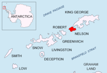
190:. Eds. C. Pimpirev and N. Chipev. Sofia: St. Kliment Ohridski University Press, 2015. pp. 17–28
141:
67:
156:
62:
38:
83:
19:
271:
137:
314:
94:
259:
87:
86:
by a 12 to 38 m wide strip of land. The area was visited by early 19th century
159:
Scale 1:200000 topographic map No. 3373. DOS 610 - W 62 58. Tolworth, UK, 1968
79:
123:
110:
140:, the south extremity of the island, and 3.24 km west-southwest of
183:
82:. It has a surface area of 1.85 ha and is separated from the waters of
93:
The feature is so named because of its shape supposedly resembling a
66:) is the 220 m long in west–east direction and 115 m wide lake on
18:
215:
222:
199:
162:
275:
52:
244:
184:
General
Geography and History of Livingston Island.
295:
8:
245:Antarctic Place-names Commission of Bulgaria
243:This article includes information from the
302:
288:
188:Bulgarian Antarctic Research: A Synthesis
270:, South Shetlands location article is a
175:
144:. British mapping of the area in 1968.
331:South Shetland Islands geography stubs
61:
7:
256:
254:
321:Lakes of the South Shetland Islands
14:
238:Adjusted Copernix satellite image
163:Antarctic Digital Database (ADD).
258:
219:Antarctic Place-names Commission
202:Antarctic Place-names Commission
247:which is used with permission.
216:Bulgarian Antarctic Gazetteer.
200:Bulgarian Antarctic Gazetteer.
136:, which is 460 m northeast of
1:
274:. You can help Knowledge by
53:
347:
326:Bulgaria and the Antarctic
253:
221:. (details in Bulgarian,
105:Kaska Lake is centred at
42:
97:('kaska' in Bulgarian).
63:['ɛzɛro'kaskɐtɐ]
157:South Shetland Islands.
76:South Shetland Islands
31:
29:South Shetland Islands
124:62.35194°S 59.04111°W
22:
142:Ivan Alexander Point
129:-62.35194; -59.04111
120: /
68:Triangulation Beach
32:
283:
282:
84:Bransfield Strait
51:
338:
304:
297:
290:
262:
255:
203:
197:
191:
180:
135:
134:
132:
131:
130:
125:
121:
118:
117:
116:
113:
65:
60:
56:
46:
44:
346:
345:
341:
340:
339:
337:
336:
335:
311:
310:
309:
308:
251:
232:
212:
207:
206:
198:
194:
181:
177:
172:
150:
128:
126:
122:
119:
114:
111:
109:
107:
106:
103:
58:
17:
12:
11:
5:
344:
342:
334:
333:
328:
323:
313:
312:
307:
306:
299:
292:
284:
281:
280:
263:
240:
239:
231:
230:External links
228:
227:
226:
211:
208:
205:
204:
192:
174:
173:
171:
168:
167:
166:
160:
154:
149:
146:
138:Vidaurre Point
102:
99:
16:Antarctic lake
15:
13:
10:
9:
6:
4:
3:
2:
343:
332:
329:
327:
324:
322:
319:
318:
316:
305:
300:
298:
293:
291:
286:
285:
279:
277:
273:
269:
268:Nelson Island
264:
261:
257:
252:
249:
248:
246:
237:
234:
233:
229:
224:
220:
217:
214:
213:
209:
201:
196:
193:
189:
185:
179:
176:
169:
164:
161:
158:
155:
152:
151:
147:
145:
143:
139:
133:
100:
98:
96:
95:combat helmet
91:
89:
85:
81:
77:
73:
72:Nelson Island
69:
64:
55:
54:ezero Kaskata
49:
43:езеро Каската
40:
36:
30:
26:
25:Nelson Island
21:
276:expanding it
265:
250:
242:
241:
195:
187:
178:
104:
92:
34:
33:
23:Location of
236:Kaska Lake.
225:in English)
182:L. Ivanov.
127: /
315:Categories
223:basic data
210:References
115:59°02′28″W
112:62°21′07″S
80:Antarctica
35:Kaska Lake
48:romanized
39:Bulgarian
101:Location
88:sealers
74:in the
50::
27:in the
266:This
170:Notes
272:stub
186:In:
148:Maps
59:IPA:
317::
90:.
78:,
70:,
57:,
45:,
41::
303:e
296:t
289:v
278:.
37:(
Text is available under the Creative Commons Attribution-ShareAlike License. Additional terms may apply.