497:
305:
317:
293:
42:
269:
329:
353:
341:
29:
49:
496:
281:
251:
was submerged with the creation of the lake. The project was finished in 1961. 40% of the total arable land went underwater as a result of the dam construction and 100,000 people were displaced. The palace of the king of the
256:
was also flooded and is also underwater. The
International Engineering Company and Utah International Inc. received the contract for the construction of the dam. The dam is 670.8 meters long, and 54.7 meters high.
587:
592:
538:
597:
582:
41:
577:
82:
316:
562:
531:
450:
408:
304:
572:
524:
232:
292:
369:
268:
567:
440:
398:
352:
557:
328:
140:
374:
504:
220:
248:
235:. Kaptai Lake's average depth is 100 feet (30 m) and maximum depth is 175 feet (53 m).
216:
126:
340:
478:
446:
404:
243:
Construction of the reservoir for the hydro-electric plant began in 1956 by the
Government of
508:
228:
147:
133:
212:
164:
154:
551:
253:
244:
114:
280:
469:
473:
224:
208:
97:
84:
119:
28:
400:
The
Economy of Tourism in Bangladesh: Prospects, Constraints, and Policies
127:
141:
482:
512:
223:. The lake was created as a result of building the
194:
186:
178:
174:
163:
153:
139:
125:
113:
74:
66:
21:
247:. 54,000 acres (220 km) of farmland in the
75:
48:
532:
8:
445:. Cambridge University Press. p. 171.
426:Daily JaiJaiDin, January 10, 2008. Page 10.
422:
420:
588:Tourist attractions in Chittagong Division
539:
525:
18:
386:
264:
159:11,122 km (4,294 sq mi)
7:
593:1962 establishments in East Pakistan
493:
491:
434:
432:
392:
390:
598:Chittagong Division geography stubs
511:. You can help Knowledge (XXG) by
14:
583:Infrastructure completed in 1962
495:
351:
339:
327:
315:
303:
291:
279:
267:
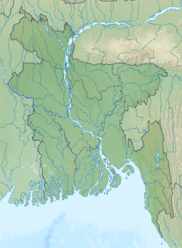
207:is the largest man-made lake in
47:
40:
27:
193:
185:
177:
578:History of Chittagong Division
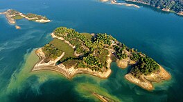
322:View of Kaptai lake, Rangamati
1:
65:
439:Schendel, Willem van (202).
233:Karnafuli Hydropower Station
370:Mahamaya irrigation project
16:Man-made lake in Bangladesh
614:
490:
35:
26:
563:Reservoirs in Bangladesh
397:Amin, Sakib Bin (2021).
70:South-Eastern Bangladesh
442:A History of Bangladesh
211:. It is located in the
198:175 ft (53 m)
190:100 ft (30 m)
507:location article is a
55:Kaptai Lake, Rangamati
22:Kaptai Lake, Rangamati
479:Kaptai Lake Rangamati
358:A Beautiful waterfall
98:22.49583°N 92.22917°E
375:Kaptai National Park
573:Chittagong Division
505:Chittagong Division
403:. Springer Nature.
221:Chittagong Division
94: /
249:Rangamati District
217:Rangamati District
103:22.49583; 92.22917
520:
519:
231:, as part of the
202:
201:
605:
568:Karnaphuli River
541:
534:
527:
499:
492:
457:
456:
436:
427:
424:
415:
414:
394:
355:
343:
331:
319:
310:Boat on the lake
307:
295:
283:
271:
229:Karnaphuli River
148:Karnaphuli River
143:
142:Primary outflows
134:Karnaphuli River
129:
109:
108:
106:
105:
104:
99:
95:
92:
91:
90:
87:
77:
51:
50:
44:
31:
19:
613:
612:
608:
607:
606:
604:
603:
602:
548:
547:
546:
545:
488:
466:
461:
460:
453:
438:
437:
430:
425:
418:
411:
396:
395:
388:
383:
366:
359:
356:
347:
344:
335:
332:
323:
320:
311:
308:
299:
296:
287:
284:
275:
272:
263:
241:
167: countries
128:Primary inflows
102:
100:
96:
93:
88:
85:
83:
81:
80:
62:
61:
60:
59:
58:
57:
56:
52:
17:
12:
11:
5:
611:
609:
601:
600:
595:
590:
585:
580:
575:
570:
565:
560:
558:Kaptai Upazila
550:
549:
544:
543:
536:
529:
521:
518:
517:
500:
486:
485:
476:
465:
464:External links
462:
459:
458:
451:
428:
416:
409:
385:
384:
382:
379:
378:
377:
372:
365:
362:
361:
360:
357:
350:
348:
345:
338:
336:
333:
326:
324:
321:
314:
312:
309:
302:
300:
297:
290:
288:
285:
278:
276:
274:Hanging Bridge
273:
266:
262:
259:
240:
237:
213:Kaptai Upazila
200:
199:
196:
192:
191:
188:
184:
183:
180:
176:
175:
172:
171:
168:
161:
160:
157:
155:Catchment area
151:
150:
145:
137:
136:
131:
123:
122:
117:
111:
110:
78:
72:
71:
68:
64:
63:
54:
53:
46:
45:
39:
38:
37:
36:
33:
32:
24:
23:
15:
13:
10:
9:
6:
4:
3:
2:
610:
599:
596:
594:
591:
589:
586:
584:
581:
579:
576:
574:
571:
569:
566:
564:
561:
559:
556:
555:
553:
542:
537:
535:
530:
528:
523:
522:
516:
514:
510:
506:
501:
498:
494:
489:
484:
480:
477:
475:
471:
468:
467:
463:
454:
452:9781108620338
448:
444:
443:
435:
433:
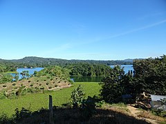
429:
423:
421:
417:
412:
410:9783030729004
406:
402:
401:
393:
391:
387:
380:
376:
373:
371:
368:
367:
363:
354:
349:
342:
337:
330:
325:
318:
313:
306:
301:
294:
289:
282:
277:
270:
265:
260:
258:
255:
250:
246:
245:East Pakistan
238:
236:
234:
230:
226:
222:
218:
214:
210:
206:
197:
189:
187:Average depth
181:
173:
169:
166:
162:
158:
156:
152:
149:
146:
144:
138:
135:
132:
130:
124:
121:
118:
116:
112:
107:
79:
73:
69:
43:
34:
30:
25:
20:
513:expanding it
502:
487:
441:
399:
298:Wooden boats
242:
204:
203:
179:Surface area
483:Travel Mate
474:Banglapedia
470:Kaptai Lake
205:Kaptai Lake
101: /
76:Coordinates
552:Categories
381:References
334:Kaptai Dam
225:Kaptai Dam
209:Bangladesh
195:Max. depth
170:Bangladesh
89:92°13′45″E
86:22°29′45″N
120:reservoir
364:See also
286:the lake
67:Location
261:Gallery
254:Chakmas
239:History
227:on the
182:688 km2
449:
407:
346:Kaptai
215:under
503:This
165:Basin
509:stub
447:ISBN
405:ISBN
115:Type
481:at
472:at
219:of
554::
431:^
419:^
389:^
540:e
533:t
526:v
515:.
455:.
413:.
Text is available under the Creative Commons Attribution-ShareAlike License. Additional terms may apply.