171:
29:
45:
179:
52:
250:
Its altitude is about 2,650 metres (8,690 ft). The surface area fluctuates, depending on winter snow fall, but is usually about 25,000 square metres (270,000 sq ft). Due to high altitude, the area around the lake is devoid of trees, although the shore is covered with shrubs and wild
274:, a high plateau at the end point of the road from the highway, is about 2 kilometres (1.2 mi) north of Karagöl. Mountaineers usually begin from Meydan Yaylası. Another interesting place is a smaller lake named
91:
354:
359:
44:
349:
194:
324:
28:
170:
364:
239:
278:
to the southwest of Karagöl and about 50 metres (160 ft) higher and 300 metres (980 ft) from Karagöl.
344:
329:
128:
223:
296:
256:
160:
73:
227:
235:
338:
123:
178:
255:, an endemic frog (Werner, 1898), which is popularly called the "Frog of Toros" (
231:
209:
196:
106:
93:
310:
238:
district of Niğde
Province. Its distance to the Turkish state highway
164:
77:
311:
A paper by Mehmet Zülfi Yıldız and bayram Göçmen ISSN 1842-9203
263:) The lake is popular with mountaineers and trekkers.
146:
138:
134:
122:
83:
69:
21:
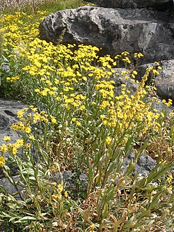
174:Yellow Chamomile (Cota tinctoria) around the lake
84:
16:Volcanic crater lake in Taurus Mountains, Turkey
33:A view of Karagöl in the Bolkar Toros Mountains
142:25,000 square metres (270,000 sq ft)
222:. It is situated almost on the borderline of
8:
18:
177:
169:
289:
51:
242:is about 20 kilometres (12 mi).
7:
14:
50:
43:
27:
191:The midpoint of the lake is at
145:
137:
159:is a small crater lake in the
1:
251:flowers. The lake is home to
68:
360:Landforms of Mersin Province
150:2,650 metres (8,690 ft)
355:Landforms of Niğde Province
381:
182:Karagöl (late Summer view)
38:
26:
230:and is accessible from
260:
183:
175:
350:Volcanic crater lakes
210:37.40306°N 34.55833°E
181:
173:
107:37.40306°N 34.55833°E
129:Volcanic crater lake
206: /
103: /
215:37.40306; 34.55833
184:
176:
112:37.40306; 34.55833
154:
153:
147:Surface elevation
372:
365:Taurus Mountains
313:
308:
302:
300:
294:
234:, a town in the
221:
220:
218:
217:
216:
211:
207:
204:
203:
202:
199:
161:Taurus Mountains
118:
117:
115:
114:
113:
108:
104:
101:
100:
99:
96:
86:
74:Taurus Mountains
54:
53:
47:
31:
19:
380:
379:
375:
374:
373:
371:
370:
369:
345:Lakes of Turkey
335:
334:
321:
316:
309:
305:
298:
295:
291:
287:
281:
269:
261:Toros kurbağası
248:
228:Mersin Province
214:
212:
208:
205:
200:
197:
195:
193:
192:
189:
111:
109:
105:
102:
97:
94:
92:
90:
89:
65:
64:
63:
62:
61:
60:
59:
55:
34:
17:
12:
11:
5:
378:
376:
368:
367:
362:
357:
352:
347:
337:
336:
333:
332:
330:For Toros frog
327:
320:
319:External links
317:
315:
314:
303:
297:Darboğaz page
288:
286:
283:
272:Meydan Yaylası
268:
267:Around Karagöl
265:
247:
244:
224:Niğde Province
188:
185:
152:
151:
148:
144:
143:
140:
136:
135:
132:
131:
126:
120:
119:
87:
81:
80:
71:
67:
66:
58:Karagöl, Toros
57:
56:
49:
48:
42:
41:
40:
39:
36:
35:
32:
24:
23:
22:Karagöl, Toros
15:
13:
10:
9:
6:
4:
3:
2:
377:
366:
363:
361:
358:
356:
353:
351:
348:
346:
343:
342:
340:
331:
328:
326:
323:
322:
318:
312:
307:
304:
301:
293:
290:
284:
282:
279:
277:
273:
266:
264:
262:
258:
254:
245:
243:
241:
237:
233:
229:
225:
219:
186:
180:
172:
168:
166:
162:
158:
149:
141:
133:
130:
127:
125:
121:
116:
88:
82:
79:
75:
72:
46:
37:
30:
25:
20:
306:
299:(in Turkish)
292:
280:
275:
271:
270:
252:
249:
190:
156:
155:
139:Surface area
253:Rana holtzi
213: /
110: /
85:Coordinates
339:Categories
325:For images
285:References
201:34°33′30″E
198:37°24′11″N
98:34°33′30″E
95:37°24′11″N
276:Çiniligöl
187:Geography
246:The lake
236:Ulukışla
232:Darboğaz
70:Location
257:Turkish
157:Karagöl
165:Turkey
78:Turkey
240:D.750
226:and
124:Type
163:in
341::
259::
167:.
76:,
Text is available under the Creative Commons Attribution-ShareAlike License. Additional terms may apply.