360:
40:
334:. There were 465 households, comprising 630 males and 624 females, giving a sex ratio of 1.01 males per female. The median age was 51.8 years (compared with 37.4 years nationally), with 225 people (18.0%) aged under 15 years, 123 (9.8%) aged 15 to 29, 579 (46.3%) aged 30 to 64, and 324 (25.9%) aged 65 or older.
350:
Of those at least 15 years old, 96 (9.4%) people had a bachelor or higher degree, and 222 (21.6%) people had no formal qualifications. The median income was $ 22,400, compared with $ 31,800 nationally. 81 people (7.9%) earned over $ 70,000 compared to 17.2% nationally. The employment status of those
242:
to the southeast. It is a right-angled land mass of two relatively distinct parts. The rocky northern part, which has an east–west orientation and is approximately 17 km long, was originally an island but is now connected to the mainland by a low sandy
606:
403:, which lies at the northern end of the eastern side of the sandy strip. Maitai Bay (formerly called Matai Bay) on the northeast coast and Rangiputa on the west coast are popular tourist destinations.
610:
2004:
259:
Karikari
Peninsula covers 174.44 km (67.35 sq mi) and had an estimated population of 1,420 as of June 2023, with a population density of 8 people per km.
337:
Ethnicities were 69.5% European/Pākehā, 44.4% Māori, 5.8% Pacific peoples, 1.4% Asian, and 1.9% other ethnicities. People may identify with more than one ethnicity.
57:
780:
2014:
677:
657:
526:
635:
1685:
343:
Of those people who chose to answer the census's question about religious affiliation, 45.8% had no religion; 43.9% were
Christian; 2.2% had
1539:
1534:
147:
1438:
590:
565:
465:
773:
1675:
1785:
887:
351:
at least 15 was that 399 (38.9%) people were employed full-time, 165 (16.1%) were part-time, and 63 (6.1%) were unemployed.
1953:
1735:
39:
1999:
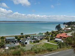
1790:
766:
1937:
1911:
1901:
1860:
1850:
1459:
652:
180:
170:
672:
640:
442:
389:
1885:
1810:
1569:
1559:
1464:
1715:
1574:
1564:
331:
327:
323:
493:
1805:
1800:
1710:
1245:
497:
1795:
1670:
1260:
1128:
1068:
1058:
922:
802:
385:
1740:
1730:
1665:
1660:
1387:
1355:
1153:
1143:
1033:
948:
912:
862:
1830:
1705:
1310:
1213:
1038:
521:
1978:
1958:
1906:
1750:
1443:
1433:
789:
247:
approximately 11 km long, which has a north–south orientation. The spiritually significant
110:
17:
1519:
378:
2009:
1820:
1765:
1755:
1725:
1720:
1695:
1218:
1193:
1188:
1168:
1163:
1133:
1025:
847:
748:
586:
561:
344:
399:, which is situated on the south side of the north-eastern part of the peninsula, and nearby
248:
1880:
1855:
1825:
1760:
1745:
1639:
1634:
1474:
1428:
1320:
1011:
943:
917:
365:
235:
227:
100:
1554:
1544:
1499:
1423:
1001:
347:; Hinduism, Islam, and Buddhism each had 0.2% as adherents; and 1.6% had other religions.
1932:
1870:
1840:
1680:
1629:
1619:
1614:
1594:
1524:
1509:
1280:
1021:
937:
897:
359:
152:
1993:
1973:
1963:
1835:
1644:
1624:
1609:
1599:
1549:
1504:
1402:
1397:
1392:
1382:
1350:
1138:
991:
981:
953:
837:
431:
400:
374:
239:
1300:
705:
1875:
1690:
1604:
1589:
1584:
1494:
1479:
1418:
996:
877:
382:
1178:
1158:
758:
340:
The percentage of people born overseas was 10.3, compared with 27.1% nationally.
1968:
1865:
1845:
1579:
1489:
1484:
1285:
1073:
1006:
971:
958:
793:
438:
396:
231:
1927:
1529:
1514:
1290:
1270:
415:
72:
59:
1469:
1325:
1265:
1223:
1173:
986:
902:
857:
1345:
1275:
1237:
1183:
1123:
1118:
1098:
1078:
1063:
932:
907:
842:
692:
1815:
1340:
1335:
1315:
1305:
1295:
1255:
1233:
1208:
1203:
1148:
1088:
1083:
966:
927:
892:
882:
867:
852:
827:
806:
434:
276:
244:
1330:
1250:
1113:
1108:
1093:
1053:
1048:
976:
832:
410:
forests, but in the 1960s the only vegetation was short scrub, some
1198:
638:. Statistics New Zealand. March 2020. Karikari Peninsula (100400).
427:
411:
407:
358:
437:. Haiti-tai-marangai Marae and meeting house are affiliated with
1103:
1043:
762:
488:
486:
418:(rushes). Grapes are grown on the northern side of Karikari.
722:
271:
740:
543:
The
Visitors' Guide to the Far North - Mangonui County
369:), a poisonous introduced weed, growing at Maitai Bay
322:
Karikari
Peninsula had a population of 1,251 at the
1946:
1920:
1894:
1778:
1653:
1452:
1411:
1375:
1368:
1232:
1020:
820:
813:
212:
204:
199:
191:
186:
176:
166:
161:
140:
132:
124:
116:
106:
96:
88:
30:
330:, and an increase of 309 people (32.8%) since the
653:"Ngāti Kurī, Ngāi Takoto, Te Pātū and Ngāti Kahu"
16:"Karikari" redirects here. For the surname, see
388:, captained by Kaiwhetu and Wairere, made its
774:
641:2018 Census place summary: Karikari Peninsula
630:
628:
8:
636:"Statistical area 1 dataset for 2018 Census"
326:, an increase of 87 people (7.5%) since the
262:
1372:
817:
781:
767:
759:
673:"Canoe traditions - Other northern canoes"
261:
251:sits high above the north-facing beaches.
27:
44:Rangaunu harbour and Rangiputa settlement
2005:Populated places in the Northland Region
708:. An Encyclopaedia of New Zealand 1966,
678:Te Ara: The Encyclopedia of New Zealand
658:Te Ara: The Encyclopedia of New Zealand
527:Te Ara: The Encyclopedia of New Zealand
516:
514:
454:
198:
185:
160:
139:
87:
52:
48:
36:
494:"Population estimate tables - NZ.Stat"
460:
458:
226:on the east coast of the far north of
195:174.44 km (67.35 sq mi)
25:Place in Northland Region, New Zealand
1686:Kaikohe-Bay of Islands volcanic field
211:
203:
190:
175:
165:
131:
123:
115:
105:
95:
7:
441:. Werowero Marae is affiliated with
583:The Geographic Atlas of New Zealand
2015:Peninsulas of the Northland Region
693:"All about the Doubtless Bay area"
585:. Robbie Burton. pp. map 17.
167: • Territorial Authority
14:
395:The two largest settlements are
38:
1676:Cape Reinga / Te Rerenga Wairua
581:Roger Smith, GeographX (2005).
426:The Karikari Peninsula has two
1786:Bay of Islands Vintage Railway
695:. Doubtless Bay Promotion Inc.
560:. Reed Books. pp. map 3.
1:
712:. Retrieved 12 December 2011.
439:Te Rorohuri / Te Whānau Moana
177: • Regional council
1736:Rainbow Falls / Waianiwaniwa
392:in New Zealand at Karikari.
1791:Butler Point Whaling Museum
741:"Te Kāhui Māngai directory"
729:. Te Potiki National Trust.
556:Peter Dowling, ed. (2004).
545:(3rd ed.). p. 26.
2031:
1851:RNZAF Station Waipapakauri
1779:Facilities and attractions
1439:Motukokako / Piercy Island
181:Northland Regional Council
171:Far North District Council
15:
800:
541:Parkes, W. F. (c. 1965).
315:
289:—
53:
49:
37:
1886:Waitangi Treaty Monument
466:"ArcGIS Web Application"
1716:Ngawha geothermal field
522:"Mangonui and district"
470:statsnz.maps.arcgis.com
345:Māori religious beliefs
324:2018 New Zealand census
1841:Okaihau Railway Branch
1806:Christ Church, Russell
1801:Cape Reinga Lighthouse
558:Reed New Zealand Atlas
498:Statistics New Zealand
443:Ngāti Tara ki Werowero
370:
216:8.1/km (21/sq mi)
73:34.85000°S 173.41667°E
1796:Cape Brett Lighthouse
1671:Cape Maria van Diemen
923:Piwhane / Spirits Bay
406:The tombolo once had
362:
263:Historical population
1741:Runaruna Mud Volcano
1731:Parengarenga Harbour
1666:Cape Brett Peninsula
1540:Rotokawau (Karikari)
1034:Cape Brett Peninsula
913:Parengarenga Harbour
213: • Density
78:-34.85000; 173.41667
1846:Opua Railway Branch
1706:Maungataniwha Range
1535:Rotokawau (Aupōuri)
1369:Geographic features
363:Cape honey flower (
355:History and culture
264:
69: /
2000:Far North District
1979:Te Waimate mission
1959:Battle of Ohaeawai
1751:Te Paki Sand Dunes
1701:Karikari Peninsula
1444:Urupukapuka Island
1434:Motukawanui Island
873:Karikari Peninsula
790:Far North District
373:The local iwi are
371:
224:Karikari Peninsula
205: • Total
192: • Total
111:Far North District
32:Karikari Peninsula
18:Karikari (surname)
1987:
1986:
1938:Northland College
1821:Kaikohe Aerodrome
1774:
1773:
1766:Whangaroa Harbour
1726:Purerua Peninsula
1696:Kaimaumau wetland
1661:Aupōuri Peninsula
1364:
1363:
888:Ninety Mile Beach
320:
319:
238:to the west, and
220:
219:
2022:
1912:Regional Council
1902:District Council
1881:Wairere Boulders
1861:St. James Church
1856:Pompallier House
1831:Māngungu Mission
1826:Kerikeri Airport
1761:Whangape Harbour
1475:Half Mile Lagoon
1429:Simmonds Islands
1388:Great Exhibition
1373:
818:
814:Populated places
783:
776:
769:
760:
753:
752:
737:
731:
730:
719:
713:
703:
697:
696:
689:
683:
682:
669:
663:
662:
649:
643:
639:
632:
623:
622:
620:
618:
609:. Archived from
603:
597:
596:
578:
572:
571:
553:
547:
546:
538:
532:
531:
518:
509:
508:
506:
504:
490:
481:
480:
478:
476:
462:
430:affiliated with
366:Melianthus major
278:
273:
265:
236:Rangaunu Harbour
101:Northland Region
84:
83:
81:
80:
79:
74:
70:
67:
66:
65:
62:
42:
28:
2030:
2029:
2025:
2024:
2023:
2021:
2020:
2019:
1990:
1989:
1988:
1983:
1974:Opo the dolphin
1942:
1916:
1890:
1770:
1649:
1448:
1424:Cavalli Islands
1407:
1360:
1228:
1016:
1002:Waitiki Landing
963:
809:
796:
787:
757:
756:
739:
738:
734:
721:
720:
716:
706:"Doubtless Bay"
704:
700:
691:
690:
686:
671:
670:
666:
651:
650:
646:
634:
633:
626:
616:
614:
613:on 30 July 2012
605:
604:
600:
593:
580:
579:
575:
568:
555:
554:
550:
540:
539:
535:
520:
519:
512:
502:
500:
492:
491:
484:
474:
472:
464:
463:
456:
451:
424:
379:Māori mythology
357:
257:
157:
77:
75:
71:
68:
63:
60:
58:
56:
55:
45:
33:
26:
21:
12:
11:
5:
2028:
2026:
2018:
2017:
2012:
2007:
2002:
1992:
1991:
1985:
1984:
1982:
1981:
1976:
1971:
1966:
1961:
1956:
1954:Arthur's Stone
1950:
1948:
1944:
1943:
1941:
1940:
1935:
1930:
1924:
1922:
1918:
1917:
1915:
1914:
1909:
1904:
1898:
1896:
1892:
1891:
1889:
1888:
1883:
1878:
1873:
1868:
1863:
1858:
1853:
1848:
1843:
1838:
1833:
1828:
1823:
1818:
1813:
1808:
1803:
1798:
1793:
1788:
1782:
1780:
1776:
1775:
1772:
1771:
1769:
1768:
1763:
1758:
1753:
1748:
1743:
1738:
1733:
1728:
1723:
1718:
1713:
1708:
1703:
1698:
1693:
1688:
1683:
1681:Horeke basalts
1678:
1673:
1668:
1663:
1657:
1655:
1651:
1650:
1648:
1647:
1642:
1637:
1632:
1627:
1622:
1617:
1612:
1607:
1602:
1597:
1592:
1587:
1582:
1577:
1572:
1567:
1562:
1557:
1552:
1547:
1542:
1537:
1532:
1527:
1522:
1517:
1512:
1507:
1502:
1497:
1492:
1487:
1482:
1477:
1472:
1467:
1462:
1456:
1454:
1450:
1449:
1447:
1446:
1441:
1436:
1431:
1426:
1421:
1415:
1413:
1409:
1408:
1406:
1405:
1400:
1395:
1390:
1385:
1379:
1377:
1370:
1366:
1365:
1362:
1361:
1359:
1358:
1353:
1348:
1343:
1338:
1333:
1328:
1323:
1318:
1313:
1308:
1303:
1298:
1293:
1288:
1283:
1281:Ngawha Springs
1278:
1273:
1268:
1263:
1258:
1253:
1248:
1242:
1240:
1230:
1229:
1227:
1226:
1221:
1216:
1211:
1206:
1201:
1196:
1191:
1186:
1181:
1176:
1171:
1166:
1161:
1156:
1151:
1146:
1141:
1136:
1131:
1126:
1121:
1116:
1111:
1106:
1101:
1096:
1091:
1086:
1081:
1076:
1071:
1069:Kerikeri Inlet
1066:
1061:
1056:
1051:
1046:
1041:
1036:
1030:
1028:
1022:Bay of Islands
1018:
1017:
1015:
1014:
1009:
1004:
999:
994:
989:
984:
979:
974:
969:
964:
962:
961:
956:
951:
946:
940:
938:Taipa-Mangonui
935:
930:
925:
920:
915:
910:
905:
900:
898:Oruru-Parapara
895:
890:
885:
880:
875:
870:
865:
860:
855:
850:
845:
840:
835:
830:
824:
822:
815:
811:
810:
801:
798:
797:
788:
786:
785:
778:
771:
763:
755:
754:
749:Te Puni Kōkiri
732:
714:
698:
684:
664:
644:
624:
598:
591:
573:
566:
548:
533:
510:
482:
453:
452:
450:
447:
423:
420:
356:
353:
318:
317:
313:
312:
309:
306:
302:
301:
298:
295:
291:
290:
287:
284:
280:
279:
274:
269:
256:
253:
218:
217:
214:
210:
209:
206:
202:
201:
197:
196:
193:
189:
188:
184:
183:
178:
174:
173:
168:
164:
163:
159:
158:
156:
155:
153:Te Tai Tokerau
150:
144:
142:
138:
137:
134:
130:
129:
126:
122:
121:
118:
114:
113:
108:
104:
103:
98:
94:
93:
90:
86:
85:
51:
50:
47:
46:
43:
35:
34:
31:
24:
13:
10:
9:
6:
4:
3:
2:
2027:
2016:
2013:
2011:
2008:
2006:
2003:
2001:
1998:
1997:
1995:
1980:
1977:
1975:
1972:
1970:
1967:
1965:
1964:Boyd massacre
1962:
1960:
1957:
1955:
1952:
1951:
1949:
1945:
1939:
1936:
1934:
1931:
1929:
1926:
1925:
1923:
1921:Organisations
1919:
1913:
1910:
1908:
1905:
1903:
1900:
1899:
1897:
1893:
1887:
1884:
1882:
1879:
1877:
1874:
1872:
1869:
1867:
1864:
1862:
1859:
1857:
1854:
1852:
1849:
1847:
1844:
1842:
1839:
1837:
1836:Mission House
1834:
1832:
1829:
1827:
1824:
1822:
1819:
1817:
1814:
1812:
1809:
1807:
1804:
1802:
1799:
1797:
1794:
1792:
1789:
1787:
1784:
1783:
1781:
1777:
1767:
1764:
1762:
1759:
1757:
1754:
1752:
1749:
1747:
1744:
1742:
1739:
1737:
1734:
1732:
1729:
1727:
1724:
1722:
1719:
1717:
1714:
1712:
1709:
1707:
1704:
1702:
1699:
1697:
1694:
1692:
1689:
1687:
1684:
1682:
1679:
1677:
1674:
1672:
1669:
1667:
1664:
1662:
1659:
1658:
1656:
1652:
1646:
1643:
1641:
1638:
1636:
1633:
1631:
1628:
1626:
1623:
1621:
1618:
1616:
1613:
1611:
1608:
1606:
1603:
1601:
1598:
1596:
1593:
1591:
1588:
1586:
1583:
1581:
1578:
1576:
1573:
1571:
1568:
1566:
1563:
1561:
1558:
1556:
1553:
1551:
1548:
1546:
1543:
1541:
1538:
1536:
1533:
1531:
1528:
1526:
1523:
1521:
1518:
1516:
1513:
1511:
1508:
1506:
1503:
1501:
1498:
1496:
1493:
1491:
1488:
1486:
1483:
1481:
1478:
1476:
1473:
1471:
1468:
1466:
1463:
1461:
1458:
1457:
1455:
1451:
1445:
1442:
1440:
1437:
1435:
1432:
1430:
1427:
1425:
1422:
1420:
1417:
1416:
1414:
1410:
1404:
1401:
1399:
1396:
1394:
1391:
1389:
1386:
1384:
1381:
1380:
1378:
1374:
1371:
1367:
1357:
1354:
1352:
1351:Waimate North
1349:
1347:
1344:
1342:
1339:
1337:
1334:
1332:
1329:
1327:
1324:
1322:
1319:
1317:
1314:
1312:
1309:
1307:
1304:
1302:
1299:
1297:
1294:
1292:
1289:
1287:
1284:
1282:
1279:
1277:
1274:
1272:
1269:
1267:
1264:
1262:
1259:
1257:
1254:
1252:
1249:
1247:
1244:
1243:
1241:
1239:
1235:
1231:
1225:
1222:
1220:
1217:
1215:
1212:
1210:
1207:
1205:
1202:
1200:
1197:
1195:
1192:
1190:
1187:
1185:
1182:
1180:
1177:
1175:
1172:
1170:
1167:
1165:
1162:
1160:
1157:
1155:
1152:
1150:
1147:
1145:
1142:
1140:
1139:Rangihoua Bay
1137:
1135:
1132:
1130:
1127:
1125:
1122:
1120:
1117:
1115:
1112:
1110:
1107:
1105:
1102:
1100:
1097:
1095:
1092:
1090:
1087:
1085:
1082:
1080:
1077:
1075:
1072:
1070:
1067:
1065:
1062:
1060:
1057:
1055:
1052:
1050:
1047:
1045:
1042:
1040:
1037:
1035:
1032:
1031:
1029:
1027:
1023:
1019:
1013:
1010:
1008:
1005:
1003:
1000:
998:
995:
993:
992:Waimahana Bay
990:
988:
985:
983:
982:Tokerau Beach
980:
978:
975:
973:
970:
968:
965:
960:
957:
955:
954:Coopers Beach
952:
950:
947:
945:
942:
941:
939:
936:
934:
931:
929:
926:
924:
921:
919:
916:
914:
911:
909:
906:
904:
901:
899:
896:
894:
891:
889:
886:
884:
881:
879:
876:
874:
871:
869:
866:
864:
861:
859:
856:
854:
851:
849:
846:
844:
841:
839:
838:Henderson Bay
836:
834:
831:
829:
826:
825:
823:
819:
816:
812:
808:
804:
799:
795:
791:
784:
779:
777:
772:
770:
765:
764:
761:
750:
746:
742:
736:
733:
728:
727:maorimaps.com
724:
718:
715:
711:
707:
702:
699:
694:
688:
685:
680:
679:
674:
668:
665:
660:
659:
654:
648:
645:
642:
637:
631:
629:
625:
612:
608:
602:
599:
594:
592:1-877333-20-4
588:
584:
577:
574:
569:
567:0-7900-0952-8
563:
559:
552:
549:
544:
537:
534:
529:
528:
523:
517:
515:
511:
499:
495:
489:
487:
483:
471:
467:
461:
459:
455:
448:
446:
444:
440:
436:
433:
429:
421:
419:
417:
413:
409:
404:
402:
401:Tokerau Beach
398:
393:
391:
390:first landing
387:
384:
380:
376:
368:
367:
361:
354:
352:
348:
346:
341:
338:
335:
333:
329:
325:
314:
310:
307:
304:
303:
299:
296:
293:
292:
288:
285:
282:
281:
275:
270:
267:
266:
260:
254:
252:
250:
246:
241:
240:Doubtless Bay
237:
234:, is between
233:
229:
225:
215:
207:
194:
182:
179:
172:
169:
154:
151:
149:
146:
145:
143:
135:
127:
119:
112:
109:
102:
99:
91:
82:
54:Coordinates:
41:
29:
23:
19:
1876:Treaty House
1711:Maungaturoto
1700:
1691:Kaikohe Hill
1520:Lake Ōmāpere
1465:Bulrush Lake
1419:Aroha Island
1194:Totara North
997:Waipapakauri
878:Lake Manuwai
872:
744:
735:
726:
723:"Māori Maps"
717:
709:
701:
687:
676:
667:
656:
647:
615:. Retrieved
611:the original
601:
582:
576:
557:
551:
542:
536:
525:
501:. Retrieved
473:. Retrieved
469:
425:
405:
394:
372:
364:
349:
342:
339:
336:
321:
258:
255:Demographics
223:
221:
22:
1969:Dog Tax War
1933:Ngāi Takoto
1871:Tāne Mahuta
1866:Stone Store
1811:Eagles Nest
1635:Waiporohita
1169:Taronui Bay
1074:Matauri Bay
1007:Whatuwhiwhi
794:New Zealand
745:tkm.govt.nz
617:24 November
475:25 December
397:Whatuwhiwhi
332:2006 census
328:2013 census
232:New Zealand
141:Electorates
136:Whatuwhiwhi
133:Subdivision
92:New Zealand
76: /
1994:Categories
1928:Muriwhenua
1895:Government
1721:North Cape
1555:Rotopokaka
1545:Rotokereru
1500:Morehurehu
1271:Matihetihe
1129:Puketotara
503:25 October
432:Ngāti Kahu
375:Ngāti Kahu
200:Population
162:Government
64:173°25′0″E
1654:Landforms
1640:Waitahora
1630:Waiparera
1620:Waimimiha
1615:Waikaramu
1595:Te Kahika
1525:Owhareiti
1510:Ngakeketa
1403:Waimahana
1398:Rangihoua
1393:Henderson
1383:Doubtless
1356:Whirinaki
1326:Rangiahua
1321:Pawarenga
1266:Mangamuka
1246:Broadwood
1224:Whangaroa
1219:Waitaruke
1179:Taupō Bay
1174:Taumarere
1159:Tākou Bay
1144:Rangitane
1026:Whangaroa
987:Waiharara
949:Cable Bay
903:Pamapuria
863:Kaingaroa
858:Kaimaumau
607:"Puwheke"
228:Northland
148:Northland
125:Community
61:34°51′0″S
2010:Tombolos
1645:Whirirau
1625:Waingaro
1610:Waikanae
1600:Wahakari
1550:Rotomata
1505:Ngakapua
1286:Ōhaeawai
1276:Mitimiti
1261:Kohukohu
1238:Hokianga
1214:Waitangi
1184:Te Haumi
1124:Puketona
1119:Pakaraka
1099:Oromahoe
1079:Maromaku
1064:Kerikeri
1059:Kawakawa
1012:Whangape
972:Te Hāpua
959:Mangōnui
933:Pukepoto
908:Paparore
843:Herekino
316:Source:
107:District
1947:History
1816:Excitor
1756:Te Puke
1605:Waihopo
1590:Tauanui
1585:Tairutu
1560:Rotoroa
1495:Manuwai
1480:Heather
1412:Islands
1341:Umawera
1336:Tautoro
1316:Panguru
1306:Opononi
1301:Ōmāpere
1296:Omanaia
1291:Ōkaihau
1256:Kaikohe
1234:Kaikohe
1209:Waipapa
1204:Waikare
1154:Russell
1149:Rawhiti
1134:Purerua
1089:Motatau
1084:Moerewa
967:Takahue
928:Pukenui
893:Oruaiti
883:Ngataki
868:Kaitaia
853:Houhora
828:Ahipara
821:Te Hiku
807:Kaikohe
386:Waipapa
277:±% p.a.
249:Puwheke
245:tombolo
128:Te Hiku
120:Te Hiku
89:Country
1746:Tarahi
1580:Taeore
1490:Kihona
1485:Kaiwai
1331:Rawene
1251:Horeke
1189:Te Tii
1114:Paihia
1109:Otiria
1094:Okiato
1054:Karetu
1049:Kapiro
1039:Haruru
977:Te Kao
833:Awanui
710:Te Ara
589:
564:
381:, the
311:+1.45%
300:+3.07%
97:Region
1907:Mayor
1570:Split
1530:Puhau
1515:Ngatu
1453:Lakes
1346:Waimā
1311:Ōtaua
1199:Towai
1164:Saies
944:Taipa
918:Peria
449:Notes
428:marae
422:Marae
412:gorse
408:kauri
377:. In
308:1,251
297:1,164
208:1,420
1575:Swan
1565:Salt
1470:Half
1376:Bays
1104:Opua
1044:Kaeo
848:Hihi
803:Seat
619:2011
587:ISBN
562:ISBN
505:2023
477:2023
435:hapū
416:wīwī
414:and
383:waka
305:2018
294:2013
283:2006
272:Pop.
268:Year
222:The
187:Area
117:Ward
1460:Big
286:942
1996::
805::
792:,
747:.
743:.
725:.
675:.
655:.
627:^
524:.
513:^
496:.
485:^
468:.
457:^
445:.
230:,
1236:/
1024:/
782:e
775:t
768:v
751:.
681:.
661:.
621:.
595:.
570:.
530:.
507:.
479:.
20:.
Text is available under the Creative Commons Attribution-ShareAlike License. Additional terms may apply.