105:
781:
89:
299:
74:
832:
64:
49:
729:
112:
404:) characterized by warm summers and cold winters with heavy snowfall. The average annual temperature in Kawaba is 9.1 °C. The average annual rainfall is 1763 mm with September as the wettest month. The temperatures are highest on average in August, at around 21.7 °C, and lowest in January, at around -2.8 °C.
352:
Located in north-central Gunma, Kawaba is in a mountainous area. Approximately 83% of its area is covered by forests, and five rivers (the
Tashiro, Sakura, Tazawa, Usune, and the Mizomata) flow through the village. Kawaba, meaning "the place of the rivers" is thought to be named after its many
615:
village council of 10 members. Kawaba, together with the other municipalities in Tone
District, contributes one member to the Gunma Prefectural Assembly. In terms of national politics, the town is part of
599:. However, this proposal was strongly opposed by the Gunma prefectural government and met with lukewarm response from Setagaya, and the village remained independent.
104:
584:
136:
780:
648:
Kawaba has one public elementary school and one public middle school operated by the village government. The village does not have a high school.
88:
636:
The economy of Kawaba is heavily dependent on agriculture; primarily rice, and apples and blueberries. Seasonal tourism to ski resorts and to
1109:
298:
1090:
621:
770:
831:
73:
748:
979:
798:
397:
325:
920:
733:
180:
168:
840:
63:
1114:
996:
925:
344:
of 110 persons per km². The total area of the village is 85.25 square kilometres (32.92 sq mi).
957:
656:
Kawaba does not have any passenger railway service and is also not connected by any national highways.
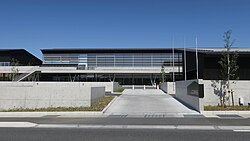
48:
1057:
1040:
1028:
808:
580:
209:
192:
763:
412:
Per
Japanese census data, the population of Kawaba has remained relatively constant for a century.
259:
899:
617:
591:
was opposed by young local politicians, who instead proposed that the village be merged with its
341:
204:
940:
568:
702:
576:
39:
1067:
1016:
989:
967:
894:
784:
380:
369:
329:
197:
1062:
984:
945:
596:
385:
1077:
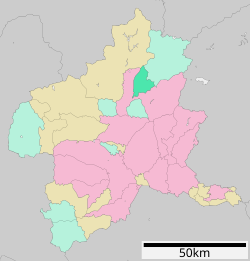
879:
185:
1006:
1001:
972:
930:
904:
874:
756:
1103:
1021:
889:
884:
869:
853:
625:
608:
588:
564:
375:
713:
1045:
1011:
962:
575:. On April 1, 1889 with the creation of the modern municipalities system after the
1050:
592:
935:
612:
572:
360:
Rivers: Tashiro River, Sakura River, Tazawa River, Usune River, Mizomata River
337:
151:
138:
250:
728:
1033:
950:
821:
816:
793:
848:
255:
740:
288:
689:
637:
333:
173:
336:. As of 31 October 2020, the village had an estimated
429:
752:
424:
297:
563:
The area of present-day Kawaba was part of the holdings of
611:
form of government with a directly elected mayor and a
278:
2390-2 Yachi, Kawaba-mura, Tone-gun, Gunma-ken 378-0101
913:
862:
839:
807:
282:
274:
266:
249:
241:
233:
228:
220:
215:
203:
191:
179:
167:
21:
317:
311:
27:
764:
8:
415:
771:
757:
749:
414:
18:
579:, Kawaba village was established within
681:
640:also play a major role in the economy.
281:
265:
248:
227:
214:
166:
131:
97:
85:
57:
45:
93:Location of Kawaba in Gunma Prefecture
273:
240:
232:
224:85.25 km (32.92 sq mi)
219:
202:
190:
178:
7:
690:"Kawaba Village official statistics"
1091:List of mergers in Gunma Prefecture
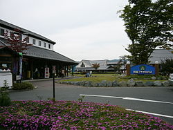
671:Roadside Station Kawaba Denen Plaza
340:of 3,241 in 1127 households, and a
14:
830:
779:
727:
302:Road station Kawaba Den-en Plaza
110:
103:
87:
72:
62:
47:
357:Mountains: Mount Hotaka (2158m)
111:
1:
1110:Villages in Gunma Prefecture
714:Kawaba population statistics
318:
1131:
365:Surrounding municipalities
1088:
828:
791:
583:. In 2002, a proposal to
442:—
398:Humid continental climate
312:
132:
98:
86:
58:
46:
37:
28:
587:Kawaba into neighboring
152:36.694639°N 139.106472°E
25:
16:Village in Kantō, Japan
303:
736:at Wikimedia Commons
692:(in Japanese). Japan.
416:Historical population
301:
245:38/km (98/sq mi)
157:36.694639; 139.106472
581:Tone District, Gunma
242: • Density
703:Kawaba climate data
417:
260:Japan Standard Time
148: /
53:Kawaba village hall
980:Kitagunma District
618:Gunma 1st district
342:population density
304:
234: • Total
221: • Total
1097:
1096:
921:Agatsuma District
802:
732:Media related to
668:Kawaba Ski Resort
660:Local attractions
577:Meiji Restoration
556:
555:
296:
295:
267:Phone number
1122:
834:
796:
785:Gunma Prefecture
783:
773:
766:
759:
750:
745:
741:Official Website
731:
716:
711:
705:
700:
694:
693:
686:
431:
426:
418:
370:Gunma Prefecture
330:Gunma Prefecture
323:
321:
315:
314:
292:
291:
289:Official website
163:
162:
160:
159:
158:
153:
149:
146:
145:
144:
141:
114:
113:
107:
91:
76:
66:
51:
32:
31:
30:
19:
1130:
1129:
1125:
1124:
1123:
1121:
1120:
1119:
1100:
1099:
1098:
1093:
1084:
926:Higashiagatsuma
909:
858:
835:
826:
803:
787:
777:
743:
725:
720:
719:
712:
708:
701:
697:
688:
687:
683:
678:
662:
654:
646:
634:
605:
597:Setagaya, Tokyo
569:Kōzuke Province
561:
410:
394:
367:
350:
309:
287:
286:
156:
154:
150:
147:
142:
139:
137:
135:
134:
128:
127:
126:
125:
122:
121:
120:
119:
115:
94:
82:
81:
80:
79:
70:
69:
54:
42:
33:
26:
24:
17:
12:
11:
5:
1128:
1126:
1118:
1117:
1112:
1102:
1101:
1095:
1094:
1089:
1086:
1085:
1083:
1082:
1081:
1080:
1075:
1070:
1065:
1055:
1054:
1053:
1048:
1038:
1037:
1036:
1026:
1025:
1024:
1019:
1014:
1009:
1004:
994:
993:
992:
987:
977:
976:
975:
970:
965:
958:Kanra District
955:
954:
953:
948:
943:
938:
933:
928:
917:
915:
911:
910:
908:
907:
902:
897:
892:
887:
882:
877:
872:
866:
864:
860:
859:
857:
856:
851:
845:
843:
841:Special cities
837:
836:
829:
827:
825:
824:
819:
813:
811:
805:
804:
792:
789:
788:
778:
776:
775:
768:
761:
753:
747:
746:
724:
723:External links
721:
718:
717:
706:
695:
680:
679:
677:
674:
673:
672:
669:
666:
665:Kichijō temple
661:
658:
653:
652:Transportation
650:
645:
642:
633:
630:
604:
601:
560:
557:
554:
553:
550:
547:
543:
542:
539:
536:
532:
531:
528:
525:
521:
520:
517:
514:
510:
509:
506:
503:
499:
498:
495:
492:
488:
487:
484:
481:
477:
476:
473:
470:
466:
465:
462:
459:
455:
454:
451:
448:
444:
443:
440:
437:
433:
432:
427:
422:
409:
406:
393:
390:
389:
388:
383:
378:
366:
363:
362:
361:
358:
349:
346:
294:
293:
284:
280:
279:
276:
272:
271:
268:
264:
263:
253:
247:
246:
243:
239:
238:
235:
231:
230:
226:
225:
222:
218:
217:
213:
212:
207:
201:
200:
195:
189:
188:
183:
177:
176:
171:
165:
164:
130:
129:
123:
117:
116:
109:
108:
102:
101:
100:
99:
96:
95:
92:
84:
83:
77:
71:
67:
61:
60:
59:
56:
55:
52:
44:
43:
38:
35:
34:
22:
15:
13:
10:
9:
6:
4:
3:
2:
1127:
1116:
1115:Kawaba, Gunma
1113:
1111:
1108:
1107:
1105:
1092:
1087:
1079:
1076:
1074:
1071:
1069:
1066:
1064:
1061:
1060:
1059:
1058:Tone District
1056:
1052:
1049:
1047:
1044:
1043:
1042:
1041:Tano District
1039:
1035:
1032:
1031:
1030:
1029:Sawa District
1027:
1023:
1020:
1018:
1015:
1013:
1010:
1008:
1005:
1003:
1000:
999:
998:
995:
991:
988:
986:
983:
982:
981:
978:
974:
971:
969:
966:
964:
961:
960:
959:
956:
952:
949:
947:
944:
942:
939:
937:
934:
932:
929:
927:
924:
923:
922:
919:
918:
916:
912:
906:
903:
901:
898:
896:
893:
891:
888:
886:
883:
881:
878:
876:
873:
871:
868:
867:
865:
861:
855:
852:
850:
847:
846:
844:
842:
838:
833:
823:
820:
818:
815:
814:
812:
810:
806:
800:
795:
790:
786:
782:
774:
769:
767:
762:
760:
755:
754:
751:
744:(in Japanese)
742:
739:
738:
737:
735:
734:Kawaba, Gunma
730:
722:
715:
710:
707:
704:
699:
696:
691:
685:
682:
675:
670:
667:
664:
663:
659:
657:
651:
649:
643:
641:
639:
631:
629:
627:
626:Diet of Japan
623:
619:
614:
610:
609:mayor-council
607:Kawaba has a
602:
600:
598:
594:
590:
586:
582:
578:
574:
570:
566:
565:Numata Domain
558:
551:
548:
545:
544:
540:
537:
534:
533:
529:
526:
523:
522:
518:
515:
512:
511:
507:
504:
501:
500:
496:
493:
490:
489:
485:
482:
479:
478:
474:
471:
468:
467:
463:
460:
457:
456:
452:
449:
446:
445:
441:
438:
435:
434:
428:
423:
420:
419:
413:
407:
405:
403:
399:
396:Kawaba has a
391:
387:
384:
382:
379:
377:
374:
373:
372:
371:
364:
359:
356:
355:
354:
347:
345:
343:
339:
335:
331:
327:
320:
308:
300:
290:
285:
277:
269:
261:
257:
254:
252:
244:
236:
223:
211:
208:
206:
199:
196:
194:
187:
184:
182:
175:
172:
170:
161:
133:Coordinates:
106:
90:
75:
65:
50:
41:
36:
20:
1072:
997:Ōra District
726:
709:
698:
684:
655:
647:
635:
606:
562:
411:
408:Demographics
401:
395:
368:
351:
306:
305:
270:0278-52-2111
143:139°6′23.3″E
140:36°41′40.7″N
900:Tatebayashi
809:Core cities
622:lower house
593:sister city
571:during the
328:located in
319:Kawaba-mura
155: /
1104:Categories
936:Naganohara
676:References
613:unicameral
603:Government
573:Edo period
338:population
229:Population
193:Prefecture
1068:Katashina
968:Shimonita
914:Districts
895:Shibukawa
644:Education
381:Katashina
353:streams.
348:Geography
251:Time zone
1063:Minakami
1034:Tamamura
985:Yoshioka
951:Tsumagoi
946:Takayama
941:Nakanojō
822:Takasaki
817:Maebashi
794:Maebashi
400:(Köppen
386:Minakami
205:District
1007:Itakura
1002:Chiyoda
973:Nanmoku
931:Kusatsu
905:Tomioka
875:Fujioka
849:Isesaki
799:capital
632:Economy
624:of the
620:of the
559:History
392:Climate
326:village
283:Website
275:Address
169:Country
40:Village
1073:Kawaba
1017:Ōizumi
990:Shintō
890:Numata
885:Midori
870:Annaka
863:Cities
589:Numata
552:−10.9%
497:−18.6%
475:+17.5%
376:Numata
307:Kawaba
181:Region
124:
118:Kawaba
23:Kawaba
1078:Shōwa
1046:Kanna
1012:Meiwa
963:Kanra
880:Kiryū
638:onsen
585:merge
549:3,480
546:2020
541:−5.6%
538:3,906
535:2010
530:+1.4%
527:4,139
524:2000
519:+4.5%
516:4,082
513:1990
508:−5.0%
505:3,905
502:1980
494:4,109
491:1970
486:−5.7%
483:5,046
480:1960
472:5,349
469:1950
464:+5.5%
461:4,552
458:1940
453:+9.0%
450:4,316
447:1930
439:3,958
436:1920
334:Japan
324:is a
256:UTC+9
237:3,241
198:Gunma
186:Kantō
174:Japan
1051:Ueno
425:Pop.
421:Year
216:Area
210:Tone
78:Seal
68:Flag
1022:Ōra
854:Ōta
567:in
402:Cfb
313:川場村
29:川場村
1106::
628:.
595:,
430:±%
332:,
316:,
801:)
797:(
772:e
765:t
758:v
322:)
310:(
262:)
258:(
Text is available under the Creative Commons Attribution-ShareAlike License. Additional terms may apply.