107:
76:
91:
730:
720:
979:
1410:
1078:
51:
766:
66:
710:
675:
114:
327:
655:
Katō has seven public elementary schools, two public middle schools and one public combined elementary/middle school operated by the city government and one public high school operated by the Hyōgo
Prefectural Department of Education. The prefecture also operates one special education school for the
606:
with the establishment of the modern municipalities system on April 1, 1889. Yashiro was elevated to town status on June 1, 1912 followed by Takino on April 1, 1925. The city of Katō, which now occupies the northern two-thirds of former Katō District was established on March 20, 2006 from the merger
448:) characterized by warm summers and cool winters with light to no snowfall. There is a relatively warm climate throughout the four seasons. There are few disasters caused by typhoons and snowfall, and the average annual temperature is slightly lower than the coastal area of the
387:
106:
745:
1447:
138:
881:
1466:
1391:
657:
90:
632:
1476:
75:
968:
1077:
1440:
756:
50:
1471:
1361:
1310:
678:
628:
603:
1344:
1332:
996:
800:
441:
1269:
564:, the region was divided into a mosaic of small holdings by various feudal domains, with large portions held by
733:
723:
178:
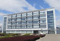
1433:
1373:
1354:
1349:
1293:
1119:
696:
1281:
836:
796:
647:
Katō is a regional commercial center, with a mixed local economy of agriculture and light manufacturing.
460:
Per
Japanese census data, the population of Katō has remained relatively steady over the past 40 years.
370:
of 250 persons per km². The total area of the city is 157.55 square kilometres (60.83 sq mi).
65:
1274:
978:
713:
688:
1132:
1086:
1028:
190:
608:
1203:
1188:
982:
961:
770:
404:
398:
359:
258:
195:
1023:
774:
386:
and many of its tributaries flow through the city. Part of the city is within the borders of the
367:
1325:
1320:
1315:
1228:
1218:
1127:
429:
1409:
1366:
1337:
1248:
1243:
1033:
910:
815:
599:
591:
1417:
1298:
1286:
1223:
1163:
1094:
595:
573:
1153:
1063:
1048:
832:
577:
557:
449:
379:
355:
41:
1303:
1233:
1213:
1178:
1173:
1168:
1158:
424:
419:
1378:
1253:
1238:
1193:
1148:
1053:
1015:
954:
790:
692:
409:
314:
304:
1460:
1208:
1058:
1043:
1038:
778:
765:
682:
636:
620:
587:
569:
414:
183:
869:
914:
1198:
1109:
631:. In terms of national politics, the city is part of Hyōgo 4th district of the
624:
565:
561:
383:
363:
254:
153:
140:
1099:
674:
249:
946:
582:
819:
1104:
326:
378:
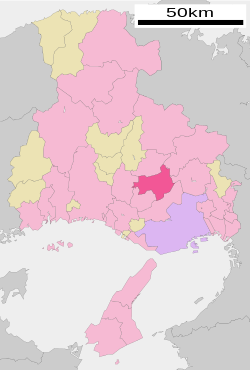
Katō is located slightly south of central Hyogo
Prefecture in the
362:, Japan. As of 30 April 2022, the city had an estimated
325:
1006:
991:
477:
950:
627:
city council of 18 members. Katō contributes one member to the
856:
938:
911:"Olympia and Kato celebrate 35-year sister city relationship"
279:
472:
660:
is located in Katō and also operates its own high school.
1421:
897:平成18年3月20日に社町、滝野町、東条町の3町が合併し、「加東市」が発足してから、市制10周年を迎えました。
623:
form of government with a directly elected mayor and a
556:
The area of the modern city of Katō was within ancient
452:, but the amount of precipitation is slightly higher.
1262:
1141:
1118:
1085:
1014:
1005:
310:
300:
273:
265:
248:
240:
232:
227:
219:
214:
206:
201:
189:
177:
169:
21:
793:, Buddhist temple with National Treasure Main Hall
388:Kiyomizu-Tōjōko-Tachikui Prefectural Natural Park
345:
339:
28:
1441:
962:
746:List of twin towns and sister cities in Japan
8:
1416:This Hyōgo Prefecture location article is a
463:
1448:
1434:
1011:
969:
955:
947:
673:
462:
18:
269:50 Yashiro, Kato-shi, Hyogo-ken 673-1493
848:
607:of Takino and Yashiro with the town of
295:
272:
264:
247:
226:
213:
200:
168:
133:
99:
87:
59:
47:
223:157.55 km (60.83 sq mi)
658:Hyogo University of Teacher Education
309:
299:
239:
231:
218:
205:
188:
176:
7:
1406:
1404:
909:Dickson, Amelia (January 23, 2016).
366:of 39,628 in 17199 households and a
95:Location of Katō in Hyōgo Prefecture
1392:List of mergers in Hyōgo Prefecture
590:was located in Katō. Following the
210:Masayoshi Yasuda (since April 2010)
1420:. You can help Knowledge (XXG) by
14:
1408:
1076:
977:
764:
728:
718:
708:
112:
105:
89:
74:
64:
49:
857:"Katō city official statistics"
1:
113:
882:"加東市制10周年記念事業要覧を作成しました|加東市"
394:Neighbouring municipalities
346:
1493:
1467:Cities in Hyōgo Prefecture
1403:
939:Katō City official website
870:Katō population statistics
751:Twin towns – Sister cities
743:
629:Hyogo Prefectural Assembly
1389:
1074:
989:
801:Saigoku Kannon Pilgrimage
490:—
442:Humid subtropical climate
340:
320:
296:
291:
287:
134:
100:
88:
60:
48:
39:
29:
25:
740:International relations
734:National Route 372
724:National Route 175
382:of the prefecture. The
244:250/km (650/sq mi)
837:Imperial Japanese Navy
827:Noted people from Kato
822:stadium in Katō, Hyōgo
331:
1477:Hyōgo geography stubs
859:(in Japanese). Japan.
799:, 25th temple on the
464:Historical population
329:
16:City in Kansai, Japan
602:were created within
241: • Density
797:Kiyomiu-dera (Katō)
594:, the villages of
465:
150: /
714:Chūgoku Expressway
368:population density
332:
233: • Total
220: • Total
207: • Mayor
154:34.917°N 134.967°E
1429:
1428:
1398:
1397:
1072:
1071:
1000:
835:, admiral in the
816:Greenhill Stadium
810:Sports facilities
785:Local attractions
656:handicapped. The
592:Meiji restoration
549:
548:
324:
323:
266:City hall address
126:Location in Japan
1484:
1450:
1443:
1436:
1412:
1405:
1311:Kanzaki District
1080:
1012:
994:
983:Hyōgo Prefecture
981:
971:
964:
957:
948:
943:
926:
925:
923:
921:
906:
900:
899:
894:
893:
878:
872:
867:
861:
860:
853:
769:
768:
732:
731:
722:
721:
712:
711:
677:
574:Hamamatsu Domain
479:
474:
466:
399:Hyōgo Prefecture
360:Hyōgo Prefecture
353:
352:
349:
343:
342:
283:
282:
280:Official website
165:
164:
162:
161:
160:
155:
151:
148:
147:
146:
143:
116:
115:
109:
93:
78:
68:
55:Kato City Office
53:
34:
33:
32:
31:
19:
1492:
1491:
1487:
1486:
1485:
1483:
1482:
1481:
1457:
1456:
1455:
1454:
1401:
1399:
1394:
1385:
1345:Mikata District
1333:Kawabe District
1258:
1137:
1114:
1081:
1068:
1001:
985:
975:
941:
935:
930:
929:
919:
917:
908:
907:
903:
891:
889:
880:
879:
875:
868:
864:
855:
854:
850:
845:
833:Keiji Shibazaki
829:
812:
787:
763:
753:
748:
742:
729:
719:
709:
705:
671:
666:
653:
645:
617:
578:Tanakura Domain
558:Harima Province
554:
458:
450:Seto Inland Sea
438:
396:
376:
350:
337:
278:
277:
159:34.917; 134.967
158:
156:
152:
149:
144:
141:
139:
137:
136:
130:
129:
128:
127:
124:
123:
122:
121:
117:
96:
84:
83:
82:
81:
72:
71:
56:
44:
35:
27:
26:
24:
17:
12:
11:
5:
1490:
1488:
1480:
1479:
1474:
1469:
1459:
1458:
1453:
1452:
1445:
1438:
1430:
1427:
1426:
1413:
1396:
1395:
1390:
1387:
1386:
1384:
1383:
1382:
1381:
1371:
1370:
1369:
1359:
1358:
1357:
1352:
1342:
1341:
1340:
1330:
1329:
1328:
1323:
1318:
1308:
1307:
1306:
1301:
1291:
1290:
1289:
1279:
1278:
1277:
1266:
1264:
1260:
1259:
1257:
1256:
1251:
1246:
1241:
1239:Tamba-Sasayama
1236:
1231:
1226:
1221:
1216:
1211:
1206:
1201:
1196:
1191:
1186:
1181:
1176:
1171:
1166:
1161:
1156:
1151:
1145:
1143:
1139:
1138:
1136:
1135:
1130:
1124:
1122:
1120:Special cities
1116:
1115:
1113:
1112:
1107:
1102:
1097:
1091:
1089:
1083:
1082:
1075:
1073:
1070:
1069:
1067:
1066:
1061:
1056:
1051:
1046:
1041:
1036:
1031:
1026:
1020:
1018:
1009:
1003:
1002:
990:
987:
986:
976:
974:
973:
966:
959:
951:
945:
944:
934:
933:External links
931:
928:
927:
901:
873:
862:
847:
846:
844:
841:
840:
839:
828:
825:
824:
823:
811:
808:
807:
806:
803:
794:
786:
783:
782:
781:
752:
749:
741:
738:
737:
736:
726:
716:
704:
701:
700:
699:
670:
667:
665:
664:Transportation
662:
652:
649:
644:
641:
616:
613:
570:Himeji Domains
553:
550:
547:
546:
543:
540:
536:
535:
532:
529:
525:
524:
521:
518:
514:
513:
510:
507:
503:
502:
499:
496:
492:
491:
488:
485:
481:
480:
475:
470:
457:
454:
437:
434:
433:
432:
427:
422:
417:
412:
407:
395:
392:
384:Kakogawa River
375:
372:
322:
321:
318:
317:
315:Cherry blossom
312:
308:
307:
302:
298:
297:
294:
293:
289:
288:
285:
284:
275:
271:
270:
267:
263:
262:
252:
246:
245:
242:
238:
237:
234:
230:
229:
225:
224:
221:
217:
216:
212:
211:
208:
204:
203:
199:
198:
193:
187:
186:
181:
175:
174:
171:
167:
166:
132:
131:
125:
119:
118:
111:
110:
104:
103:
102:
101:
98:
97:
94:
86:
85:
79:
73:
69:
63:
62:
61:
58:
57:
54:
46:
45:
40:
37:
36:
22:
15:
13:
10:
9:
6:
4:
3:
2:
1489:
1478:
1475:
1473:
1470:
1468:
1465:
1464:
1462:
1451:
1446:
1444:
1439:
1437:
1432:
1431:
1425:
1423:
1419:
1414:
1411:
1407:
1402:
1393:
1388:
1380:
1377:
1376:
1375:
1374:Taka District
1372:
1368:
1365:
1364:
1363:
1362:Sayō District
1360:
1356:
1353:
1351:
1348:
1347:
1346:
1343:
1339:
1336:
1335:
1334:
1331:
1327:
1324:
1322:
1319:
1317:
1314:
1313:
1312:
1309:
1305:
1302:
1300:
1297:
1296:
1295:
1294:Kako District
1292:
1288:
1285:
1284:
1283:
1280:
1276:
1273:
1272:
1271:
1268:
1267:
1265:
1261:
1255:
1252:
1250:
1247:
1245:
1242:
1240:
1237:
1235:
1232:
1230:
1227:
1225:
1222:
1220:
1217:
1215:
1212:
1210:
1207:
1205:
1202:
1200:
1197:
1195:
1192:
1190:
1187:
1185:
1182:
1180:
1177:
1175:
1172:
1170:
1167:
1165:
1162:
1160:
1157:
1155:
1152:
1150:
1147:
1146:
1144:
1140:
1134:
1131:
1129:
1126:
1125:
1123:
1121:
1117:
1111:
1108:
1106:
1103:
1101:
1098:
1096:
1093:
1092:
1090:
1088:
1084:
1079:
1065:
1062:
1060:
1057:
1055:
1052:
1050:
1047:
1045:
1042:
1040:
1037:
1035:
1032:
1030:
1027:
1025:
1022:
1021:
1019:
1017:
1013:
1010:
1008:
1004:
998:
993:
988:
984:
980:
972:
967:
965:
960:
958:
953:
952:
949:
942:(in Japanese)
940:
937:
936:
932:
916:
912:
905:
902:
898:
888:(in Japanese)
887:
883:
877:
874:
871:
866:
863:
858:
852:
849:
842:
838:
834:
831:
830:
826:
821:
817:
814:
813:
809:
804:
802:
798:
795:
792:
789:
788:
784:
780:
779:United States
776:
772:
767:
762:
761:
760:
758:
750:
747:
739:
735:
727:
725:
717:
715:
707:
706:
702:
698:
694:
690:
687:
686:
685:
684:
683:Kakogawa Line
680:
676:
668:
663:
661:
659:
650:
648:
642:
640:
638:
637:Diet of Japan
634:
630:
626:
622:
621:mayor-council
614:
612:
610:
605:
604:Katō District
601:
597:
593:
589:
588:Mikusa Domain
586:of the minor
585:
584:
579:
575:
571:
567:
563:
560:. During the
559:
551:
544:
541:
538:
537:
533:
530:
527:
526:
522:
519:
516:
515:
511:
508:
505:
504:
500:
497:
494:
493:
489:
486:
483:
482:
476:
471:
468:
467:
461:
455:
453:
451:
447:
443:
435:
431:
428:
426:
423:
421:
418:
416:
413:
411:
408:
406:
403:
402:
401:
400:
393:
391:
389:
385:
381:
380:Harima region
373:
371:
369:
365:
361:
357:
348:
336:
328:
319:
316:
313:
306:
303:
290:
286:
281:
276:
268:
260:
256:
253:
251:
243:
235:
222:
209:
197:
194:
192:
185:
182:
180:
172:
163:
135:Coordinates:
108:
92:
77:
67:
52:
43:
38:
20:
1422:expanding it
1415:
1400:
1282:Ibo District
1270:Akō District
1183:
918:. Retrieved
915:The Olympian
904:
896:
890:. Retrieved
885:
876:
865:
851:
754:
672:
654:
646:
618:
581:
555:
459:
456:Demographics
445:
440:Kasai has a
439:
397:
377:
334:
333:
1472:Katō, Hyōgo
1199:Minamiawaji
1110:Nishinomiya
1087:Core cities
1029:Higashinada
633:lower house
619:Katō has a
157: /
1461:Categories
1355:Shin'onsen
1133:Takarazuka
920:January 6,
892:2024-02-08
843:References
775:Washington
744:See also:
689:Yashirochō
625:unicameral
615:Government
562:Edo Period
364:population
228:Population
202:Government
191:Prefecture
1263:Districts
1204:Nishiwaki
1189:Kawanishi
1100:Amagasaki
886:Kato City
651:Education
405:Nishiwaki
374:Geography
330:Lake Tōjō
255:UTC+09:00
250:Time zone
1326:Kamikawa
1321:Ichikawa
1316:Fukusaki
1275:Kamigōri
1229:Takasago
1128:Kakogawa
820:baseball
805:LakeTōjō
791:Chōkō-ji
755:Katō is
703:Highways
444:(Köppen
430:Sasayama
347:Katō-shi
145:134°58′E
1338:Inagawa
1249:Toyooka
1244:Tatsuno
997:capital
771:Olympia
757:twinned
679:JR West
669:Railway
643:Economy
635:of the
600:Yashiro
552:History
436:Climate
292:Symbols
274:Website
170:Country
142:34°55′N
1299:Harima
1287:Taishi
1224:Sumoto
1164:Ashiya
1142:Cities
1105:Himeji
1095:Akashi
1064:Tarumi
1049:Nagata
759:with:
693:Takino
596:Takino
583:jin'ya
580:. The
542:40,181
531:40,688
523:+11.7%
520:38,270
509:34,275
498:32,149
487:34,170
305:Cosmos
301:Flower
236:39,628
184:Kansai
179:Region
80:Emblem
1304:Inami
1234:Tamba
1219:Shisō
1214:Sanda
1179:Kasai
1174:Itami
1169:Awaji
1159:Asago
1054:Nishi
1034:Hyōgo
1016:Wards
545:−1.2%
539:2010
534:+6.3%
528:2000
517:1990
512:+6.6%
506:1980
501:−5.9%
495:1970
484:1960
425:Kasai
420:Sanda
354:is a
196:Hyōgo
173:Japan
1418:stub
1379:Taka
1367:Sayō
1350:Kami
1254:Yabu
1194:Miki
1184:Katō
1149:Aioi
1059:Suma
1044:Nada
1039:Kita
1024:Chūō
1007:Kobe
992:Kobe
922:2021
818:, a
697:Taki
609:Tōjō
598:and
576:and
568:and
473:Pop.
469:Year
410:Miki
356:city
335:Katō
311:Tree
215:Area
120:Katō
70:Flag
42:City
23:Katō
1209:Ono
1154:Akō
566:Ono
446:Cfa
415:Ono
358:in
341:加東市
259:JST
30:加東市
1463::
913:.
895:.
884:.
777:,
773:,
695:-
681:-
639:.
611:.
572:,
478:±%
390:.
344:,
1449:e
1442:t
1435:v
1424:.
999:)
995:(
970:e
963:t
956:v
924:.
691:-
351:)
338:(
261:)
257:(
Text is available under the Creative Commons Attribution-ShareAlike License. Additional terms may apply.