146:
116:
139:
279:
laval flow in the Aragvi valley. A second phase 137–70ka with large scale effusive activity included the "Pyramidal Peak" Volcano which dammed local rivers with lava flows. From 90ka on activity formed Didi-Nepiskalo and the Ekisom and
Khorisar domes. The third phase less than 30ka with evidence that it continued into the Holocene formed Eastern Khorisa and Ploskaya Vershina. Activity of East Khorisar Volcano spans both stages and created lava flows in the
109:
29:
260:. In the northeastern part of the system are the Nepiskalo volcanoes and several smaller structures. The Patara-Nepiskalo volcano is strongly degraded by glacial action and may have had a caldera. Other volcanoes are Sharkhokh, Northern Shadilkhokh, and Southern Shadilkhokh in the western Kaidon range and the lava flows created by the latter two volcanoes between the
278:
first studied the volcanoes and divided the volcanism into glacial and postglacial stages. Later research indicated three phases of volcanism: A first phase 245–170ka involved lava dome formation including
Kordieritovyi dome, Patara-Nepiskalo volcano and Kabardzhin–Sakokhe centre and its associated a
414:
Lebedev, V. A.; Chernyshev, I. V.; Chugaev, A. V.; Vashakidze, G. T. (2007). "Geochronology of
Quaternary volcanism of the Krestovyi Pass Region, Kazbek Neovolcanic Area, Greater Caucasus".
372:
Lebedev, V. A.; Chernyshev, I. V.; Sharkov, E. V. (2012). "Geochronological scale and evolution of late
Cenozoic magmatism within the Caucasian segment of the alpine belt".
334:
Lebedev, V. A.; Vashakidze, G. T.; Arutyunyan, E. V.; Yakushev, A. I. (2011). "Geochronology and evolution of quaternary volcanism at the Keli
Highland, Greater Caucasus".
214:
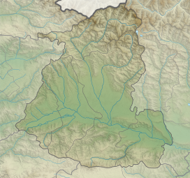
range. More than thirty volcanic edifices on an area of 20x30km make up this volcanic field, which consists mostly of monogenetic volcanic structures. The lavas are
455:
138:
108:
465:
64:
57:
470:
272:, the Ermani–Akhubata lava plateau, Eastern Sharkhokh volcano and several lava domes (Ermani, Fidarkokh and others).
256:
Western
Khorisar (elevation 3736 m) and Didi-Nepiskalo (3694 m) are the highest summits close to the crest of the
460:
308:
313:
275:
242:
269:
261:
431:
389:
351:
203:
189:
423:
381:
343:
257:
211:
176:
234:
219:
169:
449:
249:. Several mountain ranges separate the area into distinct high plains. Quaternary
28:
280:
246:
303:
283:
valley, at the end involving the collapse of the northern flank of its crater.
427:
385:
347:
207:
435:
393:
355:
79:
66:
265:
33:
223:
215:
250:
245:
originate from the Keli volcanic area, and some peaks drain into the
230:
47:
238:
253:
lava flows overlie thich
Mesozoic sedimentary sequences.
409:
407:
405:
403:
367:
365:
329:
327:
325:
323:
168:
95:
56:
46:
41:
21:
193:
8:
18:
292:
298:
296:
145:
115:
7:
14:
144:
137:
114:
107:
27:
456:Volcanoes of Georgia (country)
1:
52:3,736 m (12,257 ft)
206:on the western side of the
487:
336:Geochemistry International
428:10.1134/S1028334X07020328
386:10.1134/S1028334X11120051
348:10.1134/S0016702911090035
202:) is a volcanic field in
194:
100:
26:
16:Volcanic field in Georgia
309:Global Volcanism Program
158:Show map of Shida Kartli
314:Smithsonian Institution
416:Doklady Earth Sciences
374:Doklady Earth Sciences
466:Pleistocene volcanoes
186:Keli (Qeli) Highland
276:Nikoloz Skhirtladze
128:Show map of Georgia
76: /
471:Holocene volcanoes
42:Highest point
342:(11): 1120–1144.
270:Aragvistavi river
182:
181:
36:and Keli Highland
478:
440:
439:
411:
398:
397:
380:(2): 1656–1660.
369:
360:
359:
331:
318:
317:
300:
258:Greater Caucasus
212:Greater Caucasus
197:
196:
177:Greater Caucasus
172:
159:
148:
147:
141:
129:
118:
117:
111:
91:
90:
88:
87:
86:
81:
77:
74:
73:
72:
69:
31:
19:
486:
485:
481:
480:
479:
477:
476:
475:
461:Volcanic fields
446:
445:
444:
443:
413:
412:
401:
371:
370:
363:
333:
332:
321:
316:. 17 July 2015.
304:"Keli Highland"
302:
301:
294:
289:
220:trachyandesites
170:
164:
163:
162:
161:
160:
157:
156:
155:
154:
153:
149:
132:
131:
130:
127:
126:
125:
124:
123:
119:
84:
82:
80:42.45°N 44.25°E
78:
75:
70:
67:
65:
63:
62:
37:
17:
12:
11:
5:
484:
482:
474:
473:
468:
463:
458:
448:
447:
442:
441:
422:(1): 272–276.
399:
361:
319:
291:
290:
288:
285:
235:Patara Liakhvi
180:
179:
174:
166:
165:
151:
150:
143:
142:
136:
135:
134:
133:
121:
120:
113:
112:
106:
105:
104:
103:
102:
101:
98:
97:
93:
92:
60:
54:
53:
50:
44:
43:
39:
38:
32:
24:
23:
15:
13:
10:
9:
6:
4:
3:
2:
483:
472:
469:
467:
464:
462:
459:
457:
454:
453:
451:
437:
433:
429:
425:
421:
417:
410:
408:
406:
404:
400:
395:
391:
387:
383:
379:
375:
368:
366:
362:
357:
353:
349:
345:
341:
337:
330:
328:
326:
324:
320:
315:
311:
310:
305:
299:
297:
293:
286:
284:
282:
277:
273:
271:
267:
263:
259:
254:
252:
248:
244:
240:
236:
232:
227:
225:
221:
217:
213:
210:south to the
209:
205:
201:
191:
187:
178:
175:
173:
167:
152:Keli Highland
140:
122:Keli Highland
110:
99:
94:
89:
61:
59:
55:
51:
49:
45:
40:
35:
30:
25:
22:Keli Highland
20:
419:
415:
377:
373:
339:
335:
307:
274:
255:
243:Didi Liakhvi
231:Tetri Aragvi
228:
200:qelis zegani
199:
195:ყელის ზეგანი
185:
183:
171:Parent range
85:42.45; 44.25
281:Terek river
262:Arkhi Range
247:Terek river
229:The rivers
83: /
58:Coordinates
450:Categories
287:References
208:Jvari Pass
436:1028-334X
394:1028-334X
356:0016-7029
266:Keli Lake
224:andesites
216:rhyolites
96:Geography
48:Elevation
34:Keli Lake
268:and the
190:Georgian
204:Georgia
71:44°15′E
68:42°27′N
434:
392:
354:
251:Dacite
192::
239:Ksani
432:ISSN
390:ISSN
352:ISSN
241:and
222:and
184:The
424:doi
420:413
382:doi
378:441
344:doi
452::
430:.
418:.
402:^
388:.
376:.
364:^
350:.
340:49
338:.
322:^
312:.
306:.
295:^
264:,
237:,
233:,
226:.
218:,
198:,
438:.
426::
396:.
384::
358:.
346::
188:(
Text is available under the Creative Commons Attribution-ShareAlike License. Additional terms may apply.