217:
41:
205:
299:
238:
33:
84:. The Kemmelberg is the highest point in the province with an altitude of 154 metres (505 ft), this is the geodetic point with mark Ch63.1, as measured by the National Geographical Institute (NGI) in Brussels in October 1951 via optical levelling.
131:
seized and captured the
Kemmelberg, causing Allied troops to withdraw from all the hills in the region. Thousands of French soldiers were killed. Several streets and army barracks in Germany were named after this event (Kemmel-Privatweg in
168:
216:
704:
198:
air defence command centre was based in an underground bunker on the southern edge of the hill in the 1950s, which now operates as a visitors centre.
709:
665:
620:
581:
719:
335:
285:
172:
204:
141:
157:
263:
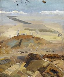
40:
331:
161:
327:
259:
128:
248:
112:
267:
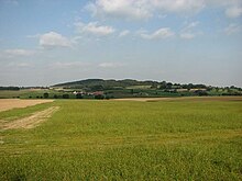
252:
145:
323:
184:
624:
319:
188:
137:
120:
714:
307:
315:
605:
97:
76:. It is located less than a kilometre from the village of Kemmel, part of the municipality of
187:. The memorial column is 17 metres (56 ft) high and depicts the Roman victory goddess
311:
61:
45:
649:
127:, started attacking the French troops on the Kemmelberg with gas grenades. At 6 a.m. the
698:
339:
149:
81:
179:
soldiers. At the top of the
Kemmelberg there is a commemorative war memorial, the
237:
176:
108:
506:
433:
360:
77:
680:
667:
133:
124:
17:
298:
69:
657:
101:
73:
32:
111:, it was the location of one of the war's most ferocious battles, the
516:
443:
370:
183:, constructed in 1932 and inaugurated by French general and war hero
92:
The earliest settlements on the
Kemmelberg date to 2,500 ago, when
297:
169:
Kemmel Number 1 French
Commonwealth War Graves Commission Cemetery
93:
39:
31:
167:
Two war cemeteries are located to the northeast of the hill, the
195:
191:. In the area, the monument is colloquially called "The Angel".
231:
306:
The steep cobbled roads over the hill frequently feature in
334:. In 1950, the Kemmelberg was included in the route of the
658:
Photos of the capture of the
Kemmelberg in Flanders, 1918
554:
546:
538:
530:
522:
512:
502:
495:
481:
473:
465:
457:
449:
439:
429:
422:
408:
400:
392:
384:
376:
366:
356:
349:
580:Nationaal Geografisch Instituut (30 April 2023).
100:populated the area. The hill takes its name from
302:The hill's steep incline on its western ascent
160:in late September 1918, as a precursor to the
8:
314:. The climb is often a decisive location in
115:, because of its strategic importance. On 25
266:. Unsourced material may be challenged and
152:was celebrated as hero of Kemmelberg — the
492:
419:
346:
286:Learn how and when to remove this message
338:, won by Belgian local and cycling icon
318:, but is also regularly included in the
123:, hoping to force a breakthrough to the
572:
200:
210:Bodies on the Kemmelberg in April 1918
36:The Kemmelberg, as seen from the west
7:
264:adding citations to reliable sources
44:1918 painting of the Kemmelberg by
48:, depicting battles of World War I
25:
705:Climbs in cycle racing in Belgium
173:Klein Vierstraat British Cemetery
236:
215:
203:
142:Friedrich Bertram Sixt von Armin
710:Mountains and hills of Flanders
158:Battle of the Peaks of Flanders
156:. It was recaptured during the
1:
181:Monument aux soldats français
162:Armistice of 11 November 1918
310:, especially in the Flemish
222:Monument for French soldiers
328:Three Days of West Flanders
27:Hill in Heuvelland, Belgium
736:
720:Landforms of West Flanders
534:1.4 km (0.87 mi)
461:2.5 km (1.6 mi)
388:3.0 km (1.9 mi)
104:, the Celtic god of war.
68:) is a hill formation in
57:
681:50.7833278°N 2.8166444°E
651:Die Eroberung des Kemmel
542:154 m (505 ft)
526:109 m (358 ft)
469:154 m (505 ft)
453:109 m (358 ft)
396:154 m (505 ft)
380:122 m (400 ft)
621:"Command Bunker Kemmel"
608:Röhms Mann fürs Ausland
332:Tour de l'Eurométropole
146:Prince Franz of Bavaria
324:Three Days of De Panne
303:
121:German imperial forces
113:Fourth Battle of Ypres
65:
49:
37:
686:50.7833278; 2.8166444
301:
148:were commanders, but
43:
35:
586:topomapviewer.ngi.be
320:Four Days of Dunkirk
260:improve this section
175:with the remains of
154:Held vom Kemmelberge
677: /
136:, Kemmelkaserne in
80:in the province of
606:Andreas Dornheim:
336:World Championship
304:
50:
38:
627:on 4 October 2017
562:
561:
539:Maximum elevation
489:
488:
466:Maximum elevation
416:
415:
393:Maximum elevation
296:
295:
288:
129:German Alpenkorps
98:Hallstatt culture
16:(Redirected from
727:
692:
691:
689:
688:
687:
682:
678:
675:
674:
673:
670:
637:
636:
634:
632:
623:. Archived from
617:
611:
603:
597:
596:
594:
592:
577:
555:Maximum gradient
547:Average gradient
523:Gain in altitude
497:Kemmelberg-South
493:
482:Maximum gradient
474:Average gradient
450:Gain in altitude
420:
409:Maximum gradient
401:Average gradient
377:Gain in altitude
347:
291:
284:
280:
277:
271:
240:
232:
219:
207:
118:
59:
21:
735:
734:
730:
729:
728:
726:
725:
724:
695:
694:
685:
683:
679:
676:
671:
668:
666:
664:
663:
646:
641:
640:
630:
628:
619:
618:
614:
604:
600:
590:
588:
582:"TopoMapViewer"
579:
578:
574:
569:
564:
563:
531:Length of climb
498:
490:
458:Length of climb
425:
424:Kemmelberg-West
417:
385:Length of climb
352:
351:Kemmelberg-East
312:spring classics
292:
281:
275:
272:
257:
241:
230:
223:
220:
211:
208:
116:
90:
46:Richard Carline
28:
23:
22:
15:
12:
11:
5:
733:
731:
723:
722:
717:
712:
707:
697:
696:
661:
660:
655:
645:
644:External links
642:
639:
638:
612:
598:
571:
570:
568:
565:
560:
559:
556:
552:
551:
548:
544:
543:
540:
536:
535:
532:
528:
527:
524:
520:
519:
514:
510:
509:
504:
500:
499:
496:
491:
487:
486:
483:
479:
478:
475:
471:
470:
467:
463:
462:
459:
455:
454:
451:
447:
446:
441:
437:
436:
431:
427:
426:
423:
418:
414:
413:
410:
406:
405:
402:
398:
397:
394:
390:
389:
386:
382:
381:
378:
374:
373:
368:
364:
363:
358:
354:
353:
350:
345:
344:
294:
293:
244:
242:
235:
229:
226:
225:
224:
221:
214:
212:
209:
202:
96:tribes of the
89:
86:
26:
24:
14:
13:
10:
9:
6:
4:
3:
2:
732:
721:
718:
716:
713:
711:
708:
706:
703:
702:
700:
693:
690:
669:50°46′59.98″N
659:
656:
653:
652:
648:
647:
643:
626:
622:
616:
613:
610:
609:
602:
599:
587:
583:
576:
573:
566:
557:
553:
549:
545:
541:
537:
533:
529:
525:
521:
518:
515:
511:
508:
505:
501:
494:
484:
480:
476:
472:
468:
464:
460:
456:
452:
448:
445:
442:
438:
435:
432:
428:
421:
411:
407:
403:
399:
395:
391:
387:
383:
379:
375:
372:
369:
365:
362:
359:
355:
348:
343:
341:
340:Briek Schotte
337:
333:
329:
325:
321:
317:
316:Gent-Wevelgem
313:
309:
308:cycling races
300:
290:
287:
279:
269:
265:
261:
255:
254:
250:
245:This section
243:
239:
234:
233:
227:
218:
213:
206:
201:
199:
197:
192:
190:
186:
182:
178:
174:
170:
165:
163:
159:
155:
151:
147:
143:
139:
135:
130:
126:
122:
114:
110:
105:
103:
99:
95:
87:
85:
83:
82:West Flanders
79:
75:
71:
67:
63:
55:
47:
42:
34:
30:
19:
672:2°48′59.92″E
662:
650:
629:. Retrieved
625:the original
615:
607:
601:
589:. Retrieved
585:
575:
305:
282:
276:October 2023
273:
258:Please help
246:
193:
180:
166:
153:
119:April 1918,
106:
91:
53:
51:
29:
684: /
654:(in German)
177:World War I
109:World War I
66:Mont Kemmel
58:Kemmel Hill
18:Kemmel Hill
715:Heuvelland
699:Categories
567:References
550:7.8 %
507:Heuvelland
477:4.4 %
434:Heuvelland
361:Heuvelland
185:Lacappelle
150:Karl Höfer
78:Heuvelland
56:(English:
54:Kemmelberg
631:4 October
558:17 %
485:22 %
412:22 %
247:does not
134:Magdeburg
125:North Sea
591:30 April
503:Location
430:Location
404:4 %
357:Location
330:and the
189:Victoria
171:and the
70:Flanders
268:removed
253:sources
228:Cycling
107:During
102:Camulos
88:History
74:Belgium
517:Kemmel
444:Kemmel
371:Kemmel
322:, the
138:Murnau
117:
94:Celtic
62:French
513:Start
440:Start
367:Start
633:2017
593:2023
251:any
249:cite
196:NATO
144:and
52:The
262:by
140:).
701::
584:.
342:.
326:,
194:A
164:.
72:,
64::
60:,
635:.
595:.
289:)
283:(
278:)
274:(
270:.
256:.
20:)
Text is available under the Creative Commons Attribution-ShareAlike License. Additional terms may apply.