42:
29:
49:
332:
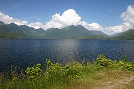
Kennedy Lake has a surface area of 6,475 hectares (16,000 acres), making it the largest lake on
Vancouver Island. It has an irregular shape made up of two basins, referred to as the Main Arm and the Clayoquot Arm, connected by a narrow sill. While the mean depth of the lake is 38 metres
333:(125 ft), the sill dividing the two arms is less than 10 metres (33 ft) depth, while the deepest part of the lake reaches 145 metres (476 ft). The lake is situated at 12 metres (39 ft) above sea level.
508:
386:
88:
41:
501:
306:
289:
and the
Clayoquot Arm Beach recreation site. The lake is a popular recreation destination for camping, boating and fishing. It is an important
494:
1147:
1245:
603:
529:
689:
615:
430:
356:
286:
270:
1250:
1240:
881:
876:
861:
1235:
278:
282:
403:
313:
1170:
336:
317:
274:
1127:
974:
896:
851:
758:
701:
846:
723:
478:
339:
winds along the south-east and southern side of the lake, the only highway accessing the communities of
321:
1107:
1082:
1037:
247:
127:
1062:
265:
The lake and surrounding region's natural beauty has led to portions of it being protected from the
969:
251:
131:
964:
255:
1142:
954:
638:
466:
460:
120:
1185:
1092:
454:
448:
28:
1122:
1047:
811:
791:
743:
658:
426:
218:
1157:
1077:
1042:
939:
871:
856:
821:
521:
419:
239:
235:
74:
70:
1180:
1057:
959:
934:
919:
801:
786:
748:
361:
290:
246:
on the island's central west coast, the lake is formed chiefly by the confluence of the
1205:
1117:
1102:
984:
944:
841:
836:
831:
796:
781:
766:
718:
683:
648:
597:
552:
542:
537:
392:. Fish and Wildlife Branch, Ministry of Forests, Lands and Natural Resource Operations.
294:
139:
1229:
1210:
1190:
1175:
1165:
1132:
1112:
1097:
1087:
1027:
1022:
989:
979:
929:
816:
806:
776:
771:
738:
663:
653:
643:
633:
592:
582:
572:
562:
259:
473:
1195:
1072:
1032:
1017:
1012:
949:
904:
886:
866:
826:
733:
668:
587:
547:
486:
1200:
1052:
1007:
924:
728:
710:
678:
673:
628:
577:
557:
517:
180:
1137:
1067:
999:
914:
909:
623:
567:
103:
90:
340:
243:
266:
121:
344:
298:
145:
302:
254:
Rivers. Outflow is via a short stretch of the
Kennedy River into
231:
490:
258:. The lake includes an extensive northern arm called
1156:
998:
895:
757:
709:
700:
614:
528:
209:
205:
197:
189:
179:
171:
163:
155:
151:
138:
119:
80:
66:
21:
418:
16:Lake on Vancouver Island, British Columbia, Canada
81:
312:The lake is part of the ancestral lands of the
387:"Vancouver Island Large Lakes Management Plan"
269:industry. Parks adjacent to the lake include
502:
8:
425:(3rd, 1997 ed.), Vancouver: UBC Press,
381:
379:
377:
316:, and is named for the last governor of the
307:Coastal Western Hemlock Biogeoclimatic Zone
706:
509:
495:
487:
18:
417:Akrigg, G.P.V.; Akrigg, Helen B. (1986),
373:
7:
48:
14:
467:Clayoquot Plateau Provincial Park
455:Kennedy River Bog Provincial Park
406:. Recreation Sites and Trails BC.
357:List of lakes of British Columbia
287:Kennedy River Bog Provincial Park
271:Clayoquot Plateau Provincial Park
47:
40:
27:
196:
188:
178:
170:
162:
154:
404:"Clayoquot Arm Beach (Tofino)"
1:
461:Clayoquot Arm Provincial Park
279:Clayoquot Arm Provincial Park
65:
449:Kennedy Lake Provincial Park
421:British Columbia Place Names
283:Kennedy Lake Provincial Park
242:, Canada. Located north of
193:111.9 km (69.5 mi)
159:6,475 ha (16,000 acres)
314:Tla-o-qui-aht First Nations
1267:
337:British Columbia Highway 4
318:Colony of Vancouver Island
219:not a well-defined measure
1246:Lakes of Vancouver Island
275:Pacific Rim National Park
216:
35:
26:
175:145 m (476 ft)
1251:Clayoquot Land District
297:and various species of
167:38 m (125 ft)
1241:Clayoquot Sound region
1128:Strait of Juan de Fuca
975:Queen Charlotte Strait
852:Princess Royal Channel
305:, and lies within the
201:12 m (39 ft)
862:Queen Charlotte Sound
847:Prince Rupert Harbour
479:BC Geographical Names
1236:Barkley Sound region
181:Residence time
100: /
1143:Trincomali Channel
955:Loughborough Inlet
322:Sir Arthur Kennedy
104:49.050°N 125.550°W
1223:
1222:
1219:
1218:
1123:Strait of Georgia
1108:Satellite Channel
1048:Discovery Passage
812:Grenville Channel
792:Finlayson Channel
744:Skidegate Channel
225:
224:
198:Surface elevation
1258:
1158:Vancouver Island
1148:Victoria Harbour
1083:Okisollo Channel
1078:Malaspina Strait
1043:Desolation Sound
940:Johnstone Strait
872:Seaforth Channel
857:Principe Channel
822:Juan Perez Sound
707:
702:Coastal features
522:British Columbia
511:
504:
497:
488:
483:
436:
435:
424:
414:
408:
407:
400:
394:
393:
391:
383:
240:British Columbia
236:Vancouver Island
217:Shore length is
123:
115:
114:
112:
111:
110:
109:49.050; -125.550
105:
101:
98:
97:
96:
93:
83:
75:British Columbia
71:Vancouver Island
51:
50:
44:
31:
19:
1266:
1265:
1261:
1260:
1259:
1257:
1256:
1255:
1226:
1225:
1224:
1215:
1181:Clayoquot Sound
1152:
1058:Homfray Channel
1038:Captain Passage
994:
960:Nodales Channel
935:Goletas Channel
920:Cordero Channel
891:
802:Fitz Hugh Sound
787:Douglas Channel
753:
749:Skidegate Inlet
696:
610:
524:
515:
472:
445:
440:
439:
433:
416:
415:
411:
402:
401:
397:
389:
385:
384:
375:
370:
362:Clayoquot Sound
353:
330:
230:is the largest
142: countries
128:Clayoquot River
122:Primary inflows
108:
106:
102:
99:
94:
91:
89:
87:
86:
62:
61:
60:
59:
58:
57:
56:
52:
17:
12:
11:
5:
1264:
1262:
1254:
1253:
1248:
1243:
1238:
1228:
1227:
1221:
1220:
1217:
1216:
1214:
1213:
1208:
1206:Quatsino Sound
1203:
1198:
1193:
1188:
1183:
1178:
1173:
1168:
1162:
1160:
1154:
1153:
1151:
1150:
1145:
1140:
1135:
1130:
1125:
1120:
1118:Stuart Channel
1115:
1110:
1105:
1103:Sansum Narrows
1100:
1095:
1090:
1085:
1080:
1075:
1070:
1065:
1063:Hoskyn Channel
1060:
1055:
1050:
1045:
1040:
1035:
1030:
1025:
1020:
1015:
1010:
1004:
1002:
996:
995:
993:
992:
987:
985:Sutlej Channel
982:
977:
972:
967:
962:
957:
952:
947:
945:Kingcome Inlet
942:
937:
932:
927:
922:
917:
912:
907:
901:
899:
893:
892:
890:
889:
884:
879:
874:
869:
864:
859:
854:
849:
844:
842:Portland Inlet
839:
837:Milbanke Sound
834:
832:Laredo Channel
829:
824:
819:
814:
809:
804:
799:
797:Fisher Channel
794:
789:
784:
782:Dixon Entrance
779:
774:
769:
767:Arthur Passage
763:
761:
755:
754:
752:
751:
746:
741:
736:
731:
726:
721:
719:Cumshewa Inlet
715:
713:
704:
698:
697:
695:
694:
686:
681:
676:
671:
666:
661:
656:
651:
646:
641:
636:
631:
626:
620:
618:
612:
611:
609:
608:
600:
595:
590:
585:
580:
575:
570:
565:
560:
555:
550:
545:
540:
534:
532:
526:
525:
516:
514:
513:
506:
499:
491:
485:
484:
474:"Kennedy Lake"
470:
464:
458:
452:
444:
443:External links
441:
438:
437:
431:
409:
395:
372:
371:
369:
366:
365:
364:
359:
352:
349:
329:
326:
223:
222:
214:
213:
211:
207:
206:
203:
202:
199:
195:
194:
191:
187:
186:
183:
177:
176:
173:
169:
168:
165:
161:
160:
157:
153:
152:
149:
148:
143:
136:
135:
125:
117:
116:
84:
78:
77:
68:
64:
63:
54:
53:
46:
45:
39:
38:
37:
36:
33:
32:
24:
23:
15:
13:
10:
9:
6:
4:
3:
2:
1263:
1252:
1249:
1247:
1244:
1242:
1239:
1237:
1234:
1233:
1231:
1212:
1211:San Josef Bay
1209:
1207:
1204:
1202:
1199:
1197:
1194:
1192:
1191:Kyuquot Sound
1189:
1187:
1184:
1182:
1179:
1177:
1176:Checleset Bay
1174:
1172:
1169:
1167:
1166:Barkley Sound
1164:
1163:
1161:
1159:
1155:
1149:
1146:
1144:
1141:
1139:
1136:
1134:
1133:Sutil Channel
1131:
1129:
1126:
1124:
1121:
1119:
1116:
1114:
1113:Sechelt Inlet
1111:
1109:
1106:
1104:
1101:
1099:
1098:Saanich Inlet
1096:
1094:
1091:
1089:
1088:Port San Juan
1086:
1084:
1081:
1079:
1076:
1074:
1071:
1069:
1066:
1064:
1061:
1059:
1056:
1054:
1051:
1049:
1046:
1044:
1041:
1039:
1036:
1034:
1031:
1029:
1028:Burrard Inlet
1026:
1024:
1023:Boundary Pass
1021:
1019:
1016:
1014:
1011:
1009:
1006:
1005:
1003:
1001:
997:
991:
990:Wells Passage
988:
986:
983:
981:
980:Seymour Inlet
978:
976:
973:
971:
970:Pryce Channel
968:
966:
963:
961:
958:
956:
953:
951:
948:
946:
943:
941:
938:
936:
933:
931:
930:Frederick Arm
928:
926:
923:
921:
918:
916:
913:
911:
908:
906:
903:
902:
900:
898:
897:Central Coast
894:
888:
885:
883:
880:
878:
875:
873:
870:
868:
865:
863:
860:
858:
855:
853:
850:
848:
845:
843:
840:
838:
835:
833:
830:
828:
825:
823:
820:
818:
817:Hecate Strait
815:
813:
810:
808:
807:Gardner Canal
805:
803:
800:
798:
795:
793:
790:
788:
785:
783:
780:
778:
777:Chatham Sound
775:
773:
772:Burke Channel
770:
768:
765:
764:
762:
760:
756:
750:
747:
745:
742:
740:
739:Rennell Sound
737:
735:
732:
730:
727:
725:
722:
720:
717:
716:
714:
712:
708:
705:
703:
699:
693:
691:
687:
685:
682:
680:
677:
675:
672:
670:
667:
665:
662:
660:
657:
655:
652:
650:
647:
645:
642:
640:
639:Great Central
637:
635:
632:
630:
627:
625:
622:
621:
619:
617:
613:
607:
605:
601:
599:
596:
594:
591:
589:
586:
584:
581:
579:
576:
574:
571:
569:
566:
564:
561:
559:
556:
554:
551:
549:
546:
544:
541:
539:
536:
535:
533:
531:
527:
523:
519:
512:
507:
505:
500:
498:
493:
492:
489:
481:
480:
475:
471:
468:
465:
462:
459:
456:
453:
450:
447:
446:
442:
434:
432:0-7748-0636-2
428:
423:
422:
413:
410:
405:
399:
396:
388:
382:
380:
378:
374:
367:
363:
360:
358:
355:
354:
350:
348:
346:
342:
338:
334:
327:
325:
323:
319:
315:
310:
308:
304:
300:
296:
292:
288:
284:
280:
276:
272:
268:
263:
261:
260:Clayoquot Arm
257:
253:
249:
245:
241:
237:
233:
229:
220:
215:
212:
208:
204:
200:
192:
184:
182:
174:
166:
164:Average depth
158:
150:
147:
144:
141:
137:
133:
132:Kennedy River
129:
126:
124:
118:
113:
85:
79:
76:
72:
69:
43:
34:
30:
25:
20:
1196:Nootka Sound
1073:Jervis Inlet
1033:Calm Channel
1018:Boundary Bay
1013:Baynes Sound
965:Phillips Arm
950:Knight Inlet
905:Belize Inlet
887:Wright Sound
867:Rivers Inlet
827:Lama Passage
734:Masset Inlet
724:Darwin Sound
688:
602:
477:
420:
412:
398:
335:
331:
311:
293:habitat for
264:
256:Tofino Inlet
228:Kennedy Lake
227:
226:
190:Shore length
156:Surface area
134:, Sand River
55:Kennedy Lake
22:Kennedy Lake
1201:Pachena Bay
1053:Haro Strait
1008:Active Pass
925:Drury Inlet
882:Smith Sound
877:Smith Inlet
759:North Coast
729:Laskeek Bay
711:Haida Gwaii
518:Hydrography
107: /
82:Coordinates
1230:Categories
1186:Hansen Bay
1171:Brooks Bay
1138:Toba Inlet
1093:Ramsay Arm
1068:Howe Sound
1000:Salish Sea
915:Call Inlet
910:Bute Inlet
368:References
210:References
172:Max. depth
684:Williston
649:Kinbasket
328:Geography
248:Clayoquot
664:Okanagan
654:Kootenay
644:Harrison
634:Cowichan
598:Thompson
553:Kootenay
543:Cowichan
538:Columbia
351:See also
341:Ucluelet
291:spawning
244:Ucluelet
185:1.1 year
95:125°33′W
67:Location
669:Shuswap
659:Nechako
593:Stikine
583:Quesnel
573:Nechako
563:Nanaimo
295:sockeye
267:logging
252:Kennedy
679:Teslin
674:Tagish
629:Babine
588:Skeena
548:Fraser
530:Rivers
429:
345:Tofino
299:salmon
146:Canada
92:49°3′N
624:Atlin
616:Lakes
578:Peace
558:Liard
390:(PDF)
303:trout
140:Basin
690:more
604:more
568:Nass
427:ISBN
343:and
301:and
250:and
232:lake
692:...
606:...
520:of
234:on
1232::
476:.
376:^
347:.
324:.
320:,
309:.
285:,
281:,
277:,
273:,
262:.
238:,
130:,
73:,
510:e
503:t
496:v
482:.
469:.
463:.
457:.
451:.
221:.
Text is available under the Creative Commons Attribution-ShareAlike License. Additional terms may apply.