371:
745:
50:
80:
87:
57:
36:
397:. Situated at an altitude of 150 m (490 ft), the lake is 27 km (17 mi) long and 11 to 102 m (36 to 335 ft) deep. "Kénogami" means "long lake" in the Montagnais dialect and was originally used to refer to
452:
The surface of Lake Kénogami is usually frozen from the beginning of
December to the end of March, however the safe circulation on the ice is generally made from mid-December to mid-March.
446:. A few secondary roads have been built in the area for the needs of hydroelectricity, forestry, recreational tourism and residents of this area (especially the northern part of the lake).
807:
146:
874:
49:
473:
884:
539:
481:
814:
727:
476:), this body of water, with an area of 59.1 km (36.72 mi) and a volume of 380 million m3 of water, is the source of the rivers
79:
370:
775:
522:
as well as the Ouiqui, Baie- dikes
Cascouia, Moncouche, Coulée-Gagnon, Creek Outlet (1, 2 and 3) and Pibrac (East and West).
432:
353:
879:
699:
533:
511:
449:
Hydroelectricity is the main economic activity in this sector; recreational tourism activities, second; forestry, third.
272:
461:
442:(boulevard Talbot); on the north side by the Kénogami road, the Route des Bâtisseurs and the Saint-Dominique street in
386:
128:
500:
715:
398:
124:
17:
427:. The three principal being the Pikauba, Cyriac and Aux-Ecorces Rivers. The towns on its shores include
200:
261:
496:
856:
795:
428:
424:
409:
405:
349:
214:
116:
204:
519:
543:
417:
188:
726:
The toponym "Lac Kénogami" was formalized on
December 5, 1968 at the Bank of Place Names of the
550:
The main characteristics (bays, points, islands) around the lake are (clockwise from the outlet
515:
567:
361:
703:
551:
529:
504:
492:
477:
439:
268:
120:
112:
706:
on 26.2 km (16.3 mi) towards the east, then the northeast and the course of the
707:
488:
413:
279:
868:
702:, corresponding to the mouth of Lake Kénogami, the current follows the course of the
465:
178:
749:
469:
443:
857:
Commission de toponymie du Québec - Bank of Place Names - Toponym: "Lac Kénogami"
808:"Characterizations on the watershed of Cascouia Bay - Municipality of Larouche"
161:
148:
843:
711:
189:
262:
394:
390:
132:
35:
844:"Atlas of Canada from the Department ofaccessda = 26 January 2019"
369:
382:
423:
The lake is fed by dozens of small rivers coming from the
438:
The area around the lake is served on the east side by
242:
décharge du lac
Central, du lac à Booyi et du lac Houle
796:
Kénogami OpenStreetMap - Accessed
December 20, 2019
582:
McDonald Bay (receiving the McDonald Creek outlet),
345:
341:
333:
325:
317:
309:
301:
293:
289:
278:
260:
187:
177:
138:
108:
28:
139:
542:(north side) whose entrance is bounded by the
510:The reservoir waters are retained by the dams
532:(east side) whose entrance is bounded by the
8:
710:on 114.6 km (71.2 mi) eastward to
770:
768:
23:Dam lake in Saguenay–Lac-Saint-Jean, Quebec
838:
836:
834:
25:
487:On its shores are the municipalities of
764:
460:Having for main hydrographic basin the
244:décharge du lac Alphonse et du lac Emma
408:150 km (93 mi) north of the
86:
56:
7:
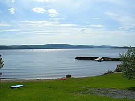
374:Couché de soleil sur le Lac Kénogami
218:décharge des Lac de la Petite Pêche
16:For the community in Ontario, see
14:
776:"The Quebec History Encyclopedia"
728:Commission de toponymie du Québec
495:and the former municipalities of
875:Lakes of Saguenay–Lac-Saint-Jean
743:
85:
78:
55:
48:
34:
412:, into which it drains via the
332:
324:
316:
313:57 km (22 sq mi)
308:
300:
292:
686:Main buildings around the lake
1:
885:Geography of Saguenay, Quebec
700:barrage de Portage-des-Roches
630:Épiphane Bay and Cascouia Bay
566:Moncouche bay (outlet of the
534:barrage de Portage-des-Roches
297:27.24 km (16.93 mi)
248:décharge du lac à Pierre-Guby
107:
462:Laurentides Wildlife Reserve
525:This lake has two outlets:
305:6.87 km (4.27 mi)
256:décharge du lac de la Ligne
901:
362:not a well-defined measure
221:North Shore (Cascouia Bay)
15:
714:where it merges with the
359:
250:Petite rivière aux Sables
235:ruisseau du Pont Flottant
42:
33:
503:now part of the city of
389:region of south-central
337:150 m (490 ft)
321:102 m (335 ft)
225:décharge du lac Charnois
585:Cabland du Chaland bay,
420:and Aux-Sables Rivers.
387:Saguenay–Lac-Saint-Jean
231:décharge du lac Culotte
229:décharge du lac Leclerc
227:décharge du lac Lésigny
129:Saguenay–Lac-Saint-Jean
716:Saint Lawrence estuary
667:Around Jean-Guy Island
404:It is situated in the
399:Kenogami Lake, Ontario
375:
254:décharge du lac Warren
246:décharge du lac à Jean
233:décharge du lac Décène
208:décharge du lac Gilles
18:Kenogami Lake, Ontario
694:Price retirees center
653:Saint-Édouard Island,
373:
252:ruisseau Jean-Dechène
162:48.32667°N 71.37611°W
880:Reservoirs in Quebec
846:. 12 September 2016.
576:Pointe aux Bouleaux,
425:Laurentian Highlands
410:Saint Lawrence River
406:Laurentian Highlands
691:Saint-Cyriac Chapel
433:Hébertville station
354:Hébertville station
201:rivière Simoncouche
167:48.32667; -71.37611
158: /
778:. marianopolis.edu
662:notch of the Curé,
616:Pointe aux Sables,
591:Pointe du Caribou,
573:the Pier-à-Chabot,
540:rivière aux Sables
512:Portage-des-Roches
376:
273:Rivière-aux-Sables
99:Show map of Canada
69:Show map of Quebec
752:
604:points to Harvey,
568:Simoncouche River
368:
367:
334:Surface elevation
210:ruisseau McDonald
892:
859:
854:
848:
847:
840:
829:
828:
826:
825:
819:
813:. Archived from
812:
804:
798:
793:
787:
786:
784:
783:
772:
750:Lakes portal
748:
747:
746:
741:
704:Chicoutimi River
638:Pointe de Sable,
563:Villa Marie bay,
552:Chicoutimi River
530:Chicoutimi River
360:Shore length is
269:Chicoutimi River
264:
263:Primary outflows
191:
173:
172:
170:
169:
168:
163:
159:
156:
155:
154:
151:
141:
100:
89:
88:
82:
70:
59:
58:
52:
38:
26:
900:
899:
895:
894:
893:
891:
890:
889:
865:
864:
863:
862:
855:
851:
842:
841:
832:
823:
821:
817:
810:
806:
805:
801:
794:
790:
781:
779:
774:
773:
766:
761:
744:
742:
736:
724:
681:Voisine Island.
647:bay to Richard,
635:bay at Simon's,
588:Finnigan point,
458:
282: countries
255:
253:
251:
249:
247:
245:
243:
241:
236:
234:
232:
230:
228:
226:
224:
219:
217:
215:rivière Pikauba
213:
212:ruisseau Patrie
211:
209:
207:
203:
199:
190:Primary inflows
166:
164:
160:
157:
152:
149:
147:
145:
144:
104:
103:
102:
101:
98:
97:
96:
95:
94:
90:
73:
72:
71:
68:
67:
66:
65:
64:
60:
24:
21:
12:
11:
5:
898:
896:
888:
887:
882:
877:
867:
866:
861:
860:
849:
830:
799:
788:
763:
762:
760:
757:
756:
755:
735:
732:
723:
720:
708:Saguenay River
696:
695:
692:
683:
682:
679:
676:
673:
664:
663:
660:
657:
654:
651:
650:Lac à Jean bay
648:
645:
642:
639:
636:
627:
626:
623:
622:Chouinard Bay,
620:
617:
614:
611:
608:
607:Epiphanes bay,
605:
602:
601:point Raphaël,
593:
592:
589:
586:
583:
580:
577:
574:
571:
564:
548:
547:
537:
457:
454:
414:Saguenay River
366:
365:
357:
356:
347:
343:
342:
339:
338:
335:
331:
330:
327:
323:
322:
319:
315:
314:
311:
307:
306:
303:
299:
298:
295:
291:
290:
287:
286:
283:
276:
275:
266:
258:
257:
205:rivière Cyriac
193:
185:
184:
181:
175:
174:
142:
136:
135:
110:
106:
105:
92:
91:
84:
83:
77:
76:
75:
74:
62:
61:
54:
53:
47:
46:
45:
44:
43:
40:
39:
31:
30:
22:
13:
10:
9:
6:
4:
3:
2:
897:
886:
883:
881:
878:
876:
873:
872:
870:
858:
853:
850:
845:
839:
837:
835:
831:
820:on 2020-10-27
816:
809:
803:
800:
797:
792:
789:
777:
771:
769:
765:
758:
754:
753:
751:
738:
737:
733:
731:
729:
721:
719:
717:
713:
709:
705:
701:
693:
690:
689:
688:
687:
680:
678:green island,
677:
675:Neighbor Bay,
674:
672:Green Island,
671:
670:
669:
668:
661:
658:
655:
652:
649:
646:
643:
640:
637:
634:
633:
632:
631:
625:Théophile bay
624:
621:
618:
615:
613:bay at Cadie,
612:
609:
606:
603:
600:
599:
598:
597:
590:
587:
584:
581:
579:McDonald tip,
578:
575:
572:
569:
565:
562:
561:
560:
559:
555:
553:
545:
541:
538:
535:
531:
528:
527:
526:
523:
521:
517:
513:
508:
506:
502:
498:
494:
490:
485:
483:
479:
475:
471:
467:
463:
455:
453:
450:
447:
445:
441:
436:
434:
430:
426:
421:
419:
415:
411:
407:
402:
400:
396:
392:
388:
384:
380:
379:Kenogami lake
372:
363:
358:
355:
351:
348:
344:
340:
336:
328:
320:
312:
304:
296:
288:
284:
281:
277:
274:
270:
267:
265:
259:
239:
222:
216:
206:
202:
197:
194:
192:
186:
182:
180:
176:
171:
143:
137:
134:
130:
126:
122:
118:
114:
111:
93:Kenogami lake
81:
63:Kenogami lake
51:
41:
37:
32:
29:Kenogami lake
27:
19:
852:
822:. Retrieved
815:the original
802:
791:
780:. Retrieved
740:
739:
725:
697:
685:
684:
666:
665:
629:
628:
619:bay Gélinas,
595:
594:
557:
556:
549:
524:
520:Pibrac-Ouest
509:
501:Lac-Kénogami
486:
459:
451:
448:
437:
429:Lac-Kénogami
422:
416:through the
403:
378:
377:
350:Lac-Kénogami
326:Shore length
310:Surface area
237:
220:
195:
117:Lac-Ministuk
656:Dufour bay,
644:Clover Bay,
610:Dufour bay,
596:North Shore
558:South Shore
544:Pibrac West
489:Hébertville
474:aux Écorces
464:(by rivers
346:Settlements
294:Max. length
238:North Shore
196:South shore
165: /
140:Coordinates
125:Hébertville
869:Categories
824:2019-12-21
782:2008-08-13
759:References
659:Gagné bay,
641:Camp lake,
516:Pibrac-Est
497:Laterrière
482:Aux Sables
478:Chicoutimi
418:Chicoutimi
381:is a long
318:Max. depth
302:Max. width
153:71°22′34″W
150:48°19′36″N
712:Tadoussac
698:From the
456:Geography
444:Jonquière
440:route 175
329:catchment
734:See also
722:Toponymy
505:Saguenay
493:Larouche
183:Dam lake
121:Larouche
113:Saguenay
109:Location
466:Pikauba
385:in the
470:Cyriac
431:, and
395:Canada
391:Quebec
285:Canada
133:Quebec
818:(PDF)
811:(PDF)
280:Basin
546:dam.
518:and
499:and
480:and
472:and
383:lake
271:and
179:Type
554:):
871::
833:^
767:^
730:.
718:.
570:),
514:,
507:.
491:,
484:.
468:,
435:.
401:.
393:,
352:,
131:,
127:,
123:/
119:/
115:/
827:.
785:.
536:;
364:.
240::
223::
198::
20:.
Text is available under the Creative Commons Attribution-ShareAlike License. Additional terms may apply.