42:
61:
572:
961:
1021:
561:
418:
517:
629:
749:
677:
1002:
606:
399:
372:
842:
526:
88:
415:
445:
1031:
687:
556:
804:
702:
799:
551:
510:
173:
1041:
877:
769:
682:
122:
It was first designated as an AONB in July 1968 and covers 878 square km (326 square miles). The AONB's highest point is
344:
995:
754:
922:
389:
362:
896:
764:
503:
252:
222:
112:
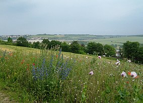
1036:
857:
169:
908:
217:
1026:
988:
819:
718:
162:
108:
50:
711:
242:
41:
789:
736:
697:
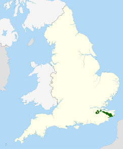
662:
654:
621:
598:
588:
119:, a prominent sandstone escarpment which lies south of the chalk escarpment of the North Downs.
867:
784:
725:
634:
441:
395:
368:
298:
142:
135:
60:
972:
435:
172:
have been adopted by 14 per cent of villages within its boundaries, going on to form part of
267:
198:
872:
774:
744:
538:
294:
176:, recognising the character of the historic landscape and distinctiveness of settlements.
158:
154:
116:
882:
794:
667:
639:
611:
546:
462:
257:
207:
157:
and reappearing within the Parc
Naturel Régional des Caps et Marais d’Opale in France.
46:
1015:
837:
827:
580:
422:
302:
272:
188:
779:
644:
262:
237:
232:
131:
127:
495:
571:
345:"Kent Downs Area of Outstanding Natural Beauty (AONB) Management Plan 2021-2026"
212:
146:
96:
17:
902:
847:
809:
277:
247:
227:
937:
924:
126:, at 250m above sea level, and its boundaries include three main rivers: the
832:
759:
672:
487:
306:
282:
202:
123:
201: – highest point in Kent at 251 metres (823 ft); near
960:
530:
150:
388:
Gallent, Nick; Juntti, Meri; Kidd, Sue; Shaw, Dave (14 January 2008).
104:
100:
161:
lies to the south east, separated by a distance of just over 2km at
192:
968:
145:
adjoins the Kent Downs AONB, and includes a continuation of the
92:
74:
499:
49:, Medway. In June, these 'unimproved' meadows are covered with
437:
The UK's County Tops: Reaching the top of 91 historic counties
325:
976:
856:
818:
735:
653:
620:
597:
579:
537:
149:which runs through the Kent Downs, stretching from
70:
34:
27:
1022:Areas of Outstanding Natural Beauty in England
297:runs through the full length of the AONB, the
191: – a dry valley north-west of
996:
511:
301:passes through the east of the AONB, and the
8:
364:Understanding Historic Building Conservation
95:, England. They are the eastern half of the
1003:
989:
518:
504:
496:
31:
65:Location of the Kent Downs AONB in the UK
750:Cranborne Chase and West Wiltshire Downs
678:Cranborne Chase and West Wiltshire Downs
184:Among the named parts of the Downs are:
318:
168:As part of the management of the AONB,
562:Suffolk & Essex Coast & Heaths
361:Forsyth, Michael (4 September 2013).
7:
957:
955:
465:. The Mountains of England and Wales
416:walks/rides available in this Valley
339:
337:
335:
333:
69:
111:, including a small section of the
975:. You can help Knowledge (XXG) by
89:Area of Outstanding Natural Beauty
25:
959:
570:
59:
40:
174:Supplementary Planning Guidance
391:Introduction to Rural Planning
1:
115:. The AONB also includes the
1058:
954:
488:Kent Downs photo group on
897:South Downs National Park
891:
568:
367:. John Wiley & Sons.
253:Lullingstone Country Park
170:Village Design Statements
113:London Borough of Bromley
58:
39:
903:New Forest National Park
440:. Cicerone. p. 32.
1032:Protected areas of Kent
461:Simon Edwardes (2001).
147:North Downs chalk ridge
51:chalk grassland flowers
971:location article is a
630:Arnside and Silverdale
463:"Historic County Tops"
326:The Kent Downs website
719:South Hampshire Coast
163:Bough Beech Reservoir
109:White Cliffs of Dover
99:and stretch from the
1042:Kent geography stubs
607:Northumberland Coast
434:Muir, Jonny (2011).
934: /
527:National Landscapes
243:Hollingbourne Downs
790:North Wessex Downs
698:North Wessex Downs
663:Chichester Harbour
589:Lincolnshire Wolds
984:
983:
917:
916:
868:Forest of Bowland
785:North Devon Coast
635:Forest of Bowland
401:978-1-134-08634-4
374:978-1-118-80684-5
299:Stour Valley Walk
143:Surrey Hills AONB
81:
80:
16:(Redirected from
1049:
1005:
998:
991:
963:
956:
949:
948:
946:
945:
944:
939:
935:
932:
931:
930:
927:
843:Shropshire Hills
574:
520:
513:
506:
497:
475:
474:
472:
470:
458:
452:
451:
431:
425:
412:
406:
405:
385:
379:
378:
358:
352:
351:
349:
341:
328:
323:
305:to the south of
268:Summerhouse Hill
63:
44:
32:
21:
1057:
1056:
1052:
1051:
1050:
1048:
1047:
1046:
1037:Chalk landforms
1012:
1011:
1010:
1009:
952:
942:
940:
936:
933:
928:
925:
923:
921:
920:
918:
913:
887:
873:Howardian Hills
859:
852:
814:
775:Isles of Scilly
745:Blackdown Hills
731:
649:
616:
593:
575:
566:
539:East of England
533:
524:
484:
479:
478:
468:
466:
460:
459:
455:
448:
433:
432:
428:
413:
409:
402:
387:
386:
382:
375:
360:
359:
355:
347:
343:
342:
331:
324:
320:
315:
295:North Downs Way
291:
182:
159:High Weald AONB
155:English Channel
117:Greensand Ridge
107:borders to the
66:
54:
28:
23:
22:
18:Kent Downs AONB
15:
12:
11:
5:
1055:
1053:
1045:
1044:
1039:
1034:
1029:
1024:
1014:
1013:
1008:
1007:
1000:
993:
985:
982:
981:
964:
938:51.29°N 0.58°E
915:
914:
912:
911:
905:
899:
892:
889:
888:
886:
885:
883:North Pennines
880:
875:
870:
864:
862:
854:
853:
851:
850:
845:
840:
835:
830:
824:
822:
816:
815:
813:
812:
807:
802:
797:
795:Quantock Hills
792:
787:
782:
777:
772:
767:
762:
757:
752:
747:
741:
739:
733:
732:
730:
729:
722:
715:
712:East Hampshire
706:
705:
700:
695:
690:
685:
680:
675:
670:
665:
659:
657:
651:
650:
648:
647:
642:
640:North Pennines
637:
632:
626:
624:
618:
617:
615:
614:
612:North Pennines
609:
603:
601:
595:
594:
592:
591:
585:
583:
577:
576:
569:
567:
565:
564:
559:
554:
549:
543:
541:
535:
534:
525:
523:
522:
515:
508:
500:
494:
493:
483:
482:External links
480:
477:
476:
453:
446:
426:
421:2007-05-02 at
407:
400:
380:
373:
353:
329:
317:
316:
314:
311:
290:
287:
286:
285:
280:
275:
270:
265:
260:
258:Ranscombe Farm
255:
250:
245:
240:
235:
230:
225:
223:Chartham Downs
220:
215:
210:
208:Blue Bell Hill
205:
196:
181:
178:
79:
78:
72:
68:
67:
64:
56:
55:
47:Ranscombe Farm
45:
37:
36:
26:
24:
14:
13:
10:
9:
6:
4:
3:
2:
1054:
1043:
1040:
1038:
1035:
1033:
1030:
1028:
1027:Hills of Kent
1025:
1023:
1020:
1019:
1017:
1006:
1001:
999:
994:
992:
987:
986:
980:
978:
974:
970:
965:
962:
958:
953:
950:
947:
910:
906:
904:
900:
898:
894:
893:
890:
884:
881:
879:
876:
874:
871:
869:
866:
865:
863:
861:
858:Yorkshire and
855:
849:
846:
844:
841:
839:
838:Malvern Hills
836:
834:
831:
829:
828:Cannock Chase
826:
825:
823:
821:
820:West Midlands
817:
811:
808:
806:
803:
801:
798:
796:
793:
791:
788:
786:
783:
781:
778:
776:
773:
771:
768:
766:
763:
761:
758:
756:
753:
751:
748:
746:
743:
742:
740:
738:
734:
728:
727:
723:
721:
720:
716:
714:
713:
708:
707:
704:
701:
699:
696:
694:
691:
689:
688:Isle of Wight
686:
684:
681:
679:
676:
674:
671:
669:
666:
664:
661:
660:
658:
656:
652:
646:
643:
641:
638:
636:
633:
631:
628:
627:
625:
623:
619:
613:
610:
608:
605:
604:
602:
600:
596:
590:
587:
586:
584:
582:
581:East Midlands
578:
573:
563:
560:
558:
557:Norfolk Coast
555:
553:
550:
548:
545:
544:
542:
540:
536:
532:
528:
521:
516:
514:
509:
507:
502:
501:
498:
492:
491:
486:
485:
481:
464:
457:
454:
449:
447:9781849655538
443:
439:
438:
430:
427:
424:
423:archive.today
420:
417:
411:
408:
403:
397:
394:. Routledge.
393:
392:
384:
381:
376:
370:
366:
365:
357:
354:
346:
340:
338:
336:
334:
330:
327:
322:
319:
312:
310:
308:
304:
303:Greensand Way
300:
296:
288:
284:
281:
279:
276:
274:
273:Tolsford Hill
271:
269:
266:
264:
261:
259:
256:
254:
251:
249:
246:
244:
241:
239:
236:
234:
231:
229:
226:
224:
221:
219:
216:
214:
211:
209:
206:
204:
200:
199:Betsom's Hill
197:
194:
190:
189:Alkham Valley
187:
186:
185:
179:
177:
175:
171:
166:
164:
160:
156:
152:
148:
144:
141:To the west,
139:
137:
133:
129:
125:
120:
118:
114:
110:
106:
102:
98:
94:
90:
86:
76:
73:
62:
57:
52:
48:
43:
38:
33:
30:
19:
977:expanding it
966:
951:
919:
901:Now part of
895:Now part of
805:Tamar Valley
780:Mendip Hills
726:Sussex Downs
724:
717:
710:
703:Surrey Hills
692:
645:Solway Coast
489:
467:. Retrieved
456:
436:
429:
410:
390:
383:
363:
356:
321:
292:
263:Samphire Hoe
238:Elham Valley
233:Detling Hill
183:
167:
140:
121:
84:
82:
29:
943:51.29; 0.58
941: /
800:South Devon
552:Dedham Vale
218:Castle Hill
213:Burham Down
97:North Downs
1016:Categories
907:Partly in
878:Nidderdale
860:the Humber
848:Wye Valley
810:Wye Valley
770:East Devon
737:South West
693:Kent Downs
683:High Weald
655:South East
622:North West
599:North East
313:References
278:Torry Hill
248:Knole Park
228:Denge Wood
124:Toy's Hill
91:(AONB) in
85:Kent Downs
35:Kent Downs
833:Cotswolds
760:Cotswolds
673:Cotswolds
668:Chilterns
547:Chilterns
307:Sevenoaks
283:Wye Downs
203:Westerham
77:, England
755:Cornwall
709:Former:
469:20 April
419:Archived
71:Location
926:51°17′N
531:England
289:Walking
153:to the
151:Farnham
929:0°35′E
765:Dorset
490:Flickr
444:
398:
371:
132:Medway
128:Darent
105:Surrey
101:London
87:is an
967:This
909:Wales
348:(PDF)
193:Dover
180:Areas
136:Stour
973:stub
969:Kent
471:2014
442:ISBN
396:ISBN
369:ISBN
293:The
134:and
93:Kent
83:The
75:Kent
529:in
1018::
332:^
309:.
165:.
138:.
130:,
1004:e
997:t
990:v
979:.
519:e
512:t
505:v
473:.
450:.
414:*
404:.
377:.
350:.
195:;
103:/
53:.
20:)
Text is available under the Creative Commons Attribution-ShareAlike License. Additional terms may apply.