155:
244:
232:
45:
256:
29:
275:
52:
220:, date from between 700 and 1100 CE. Design elements include snakes, lizards, deer, and amorphous images. The petroglyphs are considered to be heavily weathered, and in August 2010 vandals caused extensive damage by painting huge letters on them with "silvery white paint." The petroglyphs have since been restored, but the damage is still evident.
209:, and can be accessed on foot by a short, unpaved pathway known as Keyhole Sink Trail. Archaeological research suggests that not many people actually lived in Keyhole Sink, and that it was mainly used as a sort of sacred rest stop for hunters and as a place for clan initiations. Surrounding the site for a radius of fifteen miles are remnants of
231:
431:
436:
288:
421:
389:
416:
243:
44:
255:
107:
356:
312:
426:
145:
333:
100:
202:
89:
206:
385:
174:
386:"Kaibab National Forest – Vandalized Keyhole Sink Petroglyph Panel Receives Restoration Work"
28:
140:
364:
308:
280:
154:
410:
182:
270:
201:
Keyhole Sink, formerly called Box Canyon, is a few miles east of
Williams off
122:
109:
210:
190:
186:
178:
170:
93:
237:
The
Keyhole Sink Petroglyphs, as they appeared before being vandalized
217:
166:
153:
185:, which were created about 1,000 years ago by the ancient
351:
349:
139:
99:
85:
80:
72:
21:
216:The petroglyphs, which were carved into volcanic
334:"Kaibab National Forest – Keyhole Sink Trail"
16:Canyon in the Kaibab National Forest, Arizona
8:
158:Water flowing into Keyhole Sink in winter.
18:
300:
227:
432:Landforms of Coconino County, Arizona
7:
51:
437:History of Coconino County, Arizona
181:. The canyon is best known for its
249:The petroglyphs during restoration
14:
357:"Petroglyph Book – Key Hole Sink"
261:The petroglyphs after restoration
273:
254:
242:
230:
50:
43:
27:
422:Archaeological sites in Arizona
392:from the original on 2014-02-27
315:from the original on 2014-02-22
1:
417:Canyons and gorges of Arizona
76:7,024 ft (2,141 m)
33:A waterfall in Keyhole Sink.
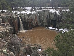
193:that flow into the canyon.
453:
189:people, and the seasonal
38:
26:
427:Petroglyphs in Arizona
361:Claude M. Shawbell III
207:Kaibab National Forest
159:
123:35.27000°N 112.01389°W
157:
128:35.27000; -112.01389
148:Sitgreaves Mountain
119: /
309:"Keyhole Sink, AZ"
169:in the shape of a
160:
152:
151:
444:
401:
400:
398:
397:
382:
376:
375:
373:
372:
363:. Archived from
353:
344:
343:
341:
340:
330:
324:
323:
321:
320:
305:
283:
278:
277:
276:
258:
246:
234:
134:
133:
131:
130:
129:
124:
120:
117:
116:
115:
112:
54:
53:
47:
31:
19:
452:
451:
447:
446:
445:
443:
442:
441:
407:
406:
405:
404:
395:
393:
384:
383:
379:
370:
368:
355:
354:
347:
338:
336:
332:
331:
327:
318:
316:
307:
306:
302:
297:
289:Sycamore Canyon
279:
274:
272:
269:
262:
259:
250:
247:
238:
235:
226:
199:
127:
125:
121:
118:
113:
110:
108:
106:
105:
90:Coconino County
73:Floor elevation
68:
67:
66:
65:
62:
61:
60:
59:
55:
34:
17:
12:
11:
5:
450:
448:
440:
439:
434:
429:
424:
419:
409:
408:
403:
402:
377:
345:
325:
299:
298:
296:
293:
292:
291:
285:
284:
281:Arizona portal
268:
265:
264:
263:
260:
253:
251:
248:
241:
239:
236:
229:
225:
222:
198:
195:
150:
149:
143:
137:
136:
103:
97:
96:
87:
83:
82:
78:
77:
74:
70:
69:
63:
57:
56:
49:
48:
42:
41:
40:
39:
36:
35:
32:
24:
23:
15:
13:
10:
9:
6:
4:
3:
2:
449:
438:
435:
433:
430:
428:
425:
423:
420:
418:
415:
414:
412:
391:
387:
381:
378:
367:on 2014-02-22
366:
362:
358:
352:
350:
346:
335:
329:
326:
314:
310:
304:
301:
294:
290:
287:
286:
282:
271:
266:
257:
252:
245:
240:
233:
228:
223:
221:
219:
214:
213:foundations.
212:
208:
204:
196:
194:
192:
188:
184:
180:
176:
172:
168:
164:
156:
147:
144:
142:
138:
132:
104:
102:
98:
95:
94:Arizona, U.S.
91:
88:
84:
79:
75:
71:
46:
37:
30:
25:
20:
394:. Retrieved
380:
369:. Retrieved
365:the original
360:
337:. Retrieved
328:
317:. Retrieved
303:
215:
200:
163:Keyhole Sink
162:
161:
58:Keyhole Sink
22:Keyhole Sink
197:Archaeology
183:petroglyphs
126: /
114:112°00′50″W
101:Coordinates
411:Categories
396:2014-02-14
371:2014-02-14
339:2014-02-14
319:2014-02-14
295:References
191:waterfalls
111:35°16′12″N
211:pit house
81:Geography
390:Archived
313:Archived
267:See also
203:Route 66
187:Cohonina
175:Williams
141:Topo map
86:Location
224:Gallery
179:Arizona
171:keyhole
135:
218:basalt
167:canyon
173:near
165:is a
146:USGS
64:none
205:in
413::
388:.
359:.
348:^
311:.
177:,
92:,
399:.
374:.
342:.
322:.
Text is available under the Creative Commons Attribution-ShareAlike License. Additional terms may apply.