72:
56:
79:
251:
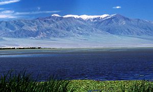
The main lake is Khar-Us Nuur ("Black water lake"), 70 km at its longest extent. Khar-Us is fed by the Khovd Gol (River), which enters in a delta on the west side. In the north of the 1,852 km lake is a large island, Agbash ("White Head"), with an area of 274 km. Immediately east of Khar-Us
232:
are bordered by marshes and reed-beds that are an important breeding sport for birds, over 200 species of which have been identified in the park. Mount
Jargalant is on the southern shore of Khar-Us. This park is distinct from
264:, with an elevation of 3,796 metres (12,454 ft). The park is surrounded by semi-arid desert steppe. The lakes, once part of a larger single lake 5,000 years ago, are fed by rivers from the surrounding
293:. At least one month averages below 0 °C (32 °F). Precipitation in the area averages 122 mm/year. The lakes are frozen for half the year (November to April). The park is situated in the
508:
563:
588:
358:
71:
501:
481:
644:
583:
289:). This climate is characteristic of steppe climates intermediary between desert humid climates, and typically have precipitation is above
124:
649:
618:
494:
533:
517:
338:
538:
456:
283:
294:
608:
528:
41:
613:
322:
260:(300 km) to the southeast. The first two lakes are freshwater, the third is saline. On the southern edge of Khar-Us is
598:
568:
543:
234:
639:
573:
548:
329:) were introduced to the area for fur production; they have grown in number and place pressure on the reed beds.
202:
603:
359:"Capacity And Financial Need Assessment of Protected Areas Located in the Altai Sayan Ecoregion of Mongolia"
317:(Pelecanus crispus) (formerly breeding in the park, but lately only passing through), and the vulnerable
321:(Anser cygnoides). There are three species of endemic fish, including the Narrow-headed Altai osman (
553:
383:
261:
220:. It covers a chain of three large lakes in the Great Lakes Basin of western Mongolia. The lakes,
578:
326:
290:
193:
29:
314:
310:
286:
278:
257:
253:
229:
225:
160:
265:
431:
213:
98:
633:
593:
45:
246:
221:
112:
55:
164:
408:
318:
306:
486:
139:
126:
217:
102:
430:
Kottek, M.; Grieser, J.; Beck, C.; Rudolf, B.; Rubel, F. (2006).
237:, another large lake in the region, but 60 km to the north.
490:
482:
Park borders, Khar-Us Nuur
National Park, ProtectedPlanet.net
432:"World Map of Koppen-Geiger Climate Classification Updated"
256:("Black Lake", 565 km), which is connected by a canal with
183:
Ministry of
Environment and Green Development of Mongolia
207:
179:
171:
155:
118:
108:
94:
21:
78:
502:
8:
313:(Oxyura leucocephala), the near-threatened
509:
495:
487:
457:"Dataset - Koppen climate classifications"
209:Khar Us nuuriin baigaliin cogcolbort gazar
18:
16:National park in Khovd Province, Mongolia
403:
401:
198:Хар Ус нуурын байгалийн цогцолборт газар
350:
309:(reeds). Birds include the endangered
7:
93:
339:List of national parks of Mongolia
14:
77:
70:
54:
295:Great Lakes Basin desert steppe
170:
107:
1:
323:Oreoleuciscus angusticephalus
284:Köppen climate classification
589:Khorgo-Terkhiin Tsagaan Nuur
409:"Khar Us Nuur National Park"
384:"Khar-Us Nuur National Park"
645:Landforms of Khovd Province
437:. Gebrüder Borntraeger 2006
325:). in the 1960s, muskrat (
276:The climate of the area is
235:Khyargas Nuur National Park
208:
666:
650:National parks of Mongolia
518:National parks of Mongolia
244:
190:Khar Us Nuur National Park
524:
197:
65:
53:
39:
33:
26:
22:Har Us Nuur National Park
386:. Birdlife International
305:The marshes are largely
212:) is a national park in
279:Cold semi-arid climate
619:Ulaagchinii Khar Nuur
272:Climate and ecoregion
534:Bulgan Gol-Ikh Ongog
27:(Also: Khar-Us Nuur)
411:. Ramsar Convention
307:Phragmites communis
180:Governing body
136: /
539:Gobi Gurvansaikhan
327:Ondatra zibethicus
291:evapotranspiration
262:Jargalant Mountain
60:Jargalant Mountain
627:
626:
315:Dalmatian pelican
311:White-headed duck
206:
187:
186:
161:square kilometres
109:Nearest city
657:
640:IUCN Category II
609:Tarvagatai Nuruu
529:Altai Tavan Bogd
511:
504:
497:
488:
469:
468:
466:
464:
453:
447:
446:
444:
442:
436:
427:
421:
420:
418:
416:
405:
396:
395:
393:
391:
380:
374:
373:
371:
369:
363:
355:
211:
201:
199:
151:
150:
148:
147:
146:
141:
137:
134:
133:
132:
129:
86:Location of Park
81:
80:
74:
58:
35:
19:
665:
664:
660:
659:
658:
656:
655:
654:
630:
629:
628:
623:
614:Tsambagarav Uul
520:
515:
478:
473:
472:
462:
460:
455:
454:
450:
440:
438:
434:
429:
428:
424:
414:
412:
407:
406:
399:
389:
387:
382:
381:
377:
367:
365:
361:
357:
356:
352:
347:
335:
303:
301:Flora and fauna
274:
266:Altai Mountains
249:
243:
144:
142:
138:
135:
130:
127:
125:
123:
122:
90:
89:
88:
87:
84:
83:
82:
61:
49:
28:
17:
12:
11:
5:
663:
661:
653:
652:
647:
642:
632:
631:
625:
624:
622:
621:
616:
611:
606:
601:
599:Munkhkhairkhan
596:
591:
586:
581:
576:
571:
566:
561:
556:
551:
546:
541:
536:
531:
525:
522:
521:
516:
514:
513:
506:
499:
491:
485:
484:
477:
476:External links
474:
471:
470:
448:
422:
397:
375:
364:. WWF-Mongolia
349:
348:
346:
343:
342:
341:
334:
331:
302:
299:
273:
270:
245:Main article:
242:
239:
214:Khovd Province
185:
184:
181:
177:
176:
173:
169:
168:
157:
153:
152:
140:48.3°N 92.74°E
120:
116:
115:
110:
106:
105:
99:Khovd Province
96:
92:
91:
85:
76:
75:
69:
68:
67:
66:
63:
62:
59:
51:
50:
40:
37:
36:
24:
23:
15:
13:
10:
9:
6:
4:
3:
2:
662:
651:
648:
646:
643:
641:
638:
637:
635:
620:
617:
615:
612:
610:
607:
605:
602:
600:
597:
595:
594:Khyargas Nuur
592:
590:
587:
585:
582:
580:
579:Lake Khövsgöl
577:
575:
572:
570:
569:Khangai Nuruu
567:
565:
562:
560:
557:
555:
552:
550:
547:
545:
544:Gorkhi-Terelj
542:
540:
537:
535:
532:
530:
527:
526:
523:
519:
512:
507:
505:
500:
498:
493:
492:
489:
483:
480:
479:
475:
463:September 14,
458:
452:
449:
441:September 14,
433:
426:
423:
410:
404:
402:
398:
385:
379:
376:
360:
354:
351:
344:
340:
337:
336:
332:
330:
328:
324:
320:
316:
312:
308:
300:
298:
296:
292:
288:
285:
281:
280:
271:
269:
267:
263:
259:
255:
248:
240:
238:
236:
231:
227:
223:
219:
215:
210:
204:
195:
191:
182:
178:
174:
166:
162:
158:
154:
149:
121:
117:
114:
111:
104:
100:
97:
73:
64:
57:
52:
47:
46:national park
43:
42:IUCN category
38:
31:
25:
20:
584:Khan Khentii
559:Khar-Us Nuur
558:
461:. Retrieved
459:. World Bank
451:
439:. Retrieved
425:
413:. Retrieved
388:. Retrieved
378:
366:. Retrieved
353:
304:
277:
275:
250:
247:Khar-Us Nuur
222:Khar-Us Nuur
189:
188:
163:(3,283
574:Khogno Khan
564:Khan-Khokhi
297:ecoregion.
258:Dörgön Lake
230:Dörgön Lake
172:Established
145:48.3; 92.74
143: /
119:Coordinates
34:Хар Ус Нуур
634:Categories
549:Gun-Galuut
345:References
319:Swan goose
241:Topography
165:sq mi
604:Onon-Balj
415:April 25,
390:April 25,
368:April 25,
254:Khar Lake
226:Khar Lake
203:romanized
194:Mongolian
30:Mongolian
333:See also
218:Mongolia
103:Mongolia
95:Location
205::
131:92°44′E
128:48°18′N
554:Hustai
159:8,503
435:(PDF)
362:(PDF)
287:(BSk)
113:Khovd
465:2019
443:2019
417:2020
392:2020
370:2020
228:and
175:1997
156:Area
44:II (
252:is
636::
400:^
268:.
224:,
216:,
200:,
196::
101:,
32::
510:e
503:t
496:v
467:.
445:.
419:.
394:.
372:.
282:(
192:(
167:)
48:)
Text is available under the Creative Commons Attribution-ShareAlike License. Additional terms may apply.