52:
961:
69:
1091:
102:
1221:
949:
973:
181:
985:
109:
76:
588:
The elevations of Khumbu
Pasanglhamu is not equal, it starts from 2000m and ends at 8848m thus the climate in the region can be divided into four climate zones owing to the gradual rise in altitude. The climatic zones include a forested lower zone, a zone of alpine scrub, the upper alpine zone which
530:
Khumbu
Pasanglhamu is situated at coordinates 27.74° N 86.73° E Latitude and longitude. It is on northernmost part of Province, which is highest altitude land on Earth, part of higher Himalayas. Geographical condition of Khumbu Pasanglhamu is very difficult. It is the highest elevated land of the
531:
world. The minimum elevation of the region is 1,900 metres (6,200 ft), whereas the maximum elevation is 8,848 metres (29,029 ft). The total area of the rural municipality is 1,539.11 square kilometres (594.25 sq mi), thus it is the second largest
589:
includes upper limit of vegetation growth, and the Arctic zone thus the temperature and weather conditions vary at different altitudes or zones. The upper zones are snow-capped mountains which is too cold and the lower zone's valleys are some less cold.
1600:
1300:
1016:
51:
141:
1605:
510:. "Solukhumbu" is a combination of two words; "Solu" and "Khumbu". Solu is lower part, while Khumbu is upper part of Solukhumbu District. The "Pasanglhamu" word is taken from
1595:
1293:
1173:
68:
1286:
960:
472:
101:
1166:
484:
1459:
1359:
1336:
1318:
1229:
1202:
1419:
1063:
1109:
1514:
1590:
1159:
433:
1585:
1559:
1499:
1489:
448:
and area of 1,539.11 square kilometres (594.25 sq mi). The admin centre of this gaunpalika is that of the
1414:
972:
1529:
1494:
1469:
359:
173:
1399:
17:
948:
268:
1394:
1262:
1220:
1193:
1182:
511:
503:
476:
409:
210:
1067:
544:
205:
193:
984:
1037:
1012:
1564:
445:
1429:
444:
were incorporated while creating it. It has the total population of 9,133 according to the
1374:
480:
397:
1524:
1504:
1310:
536:
413:
198:
1579:
1474:
1409:
1237:
1210:
854:
515:
460:
425:
241:
1434:
1278:
1242:
540:
468:
449:
441:
375:
369:
135:
1519:
1509:
1252:
1134:
1539:
1484:
1479:
1369:
1326:
1267:
562:
532:
405:
351:
42:
156:
143:
1554:
1534:
1449:
1444:
1247:
582:
347:
342:
585:, Forche, Pangboche, Phiriche etc. are the human settlement in the region.
1549:
1439:
1424:
1379:
578:
456:
421:
1404:
1389:
1344:
569:, Thamserku etc. are the mountains located in this region. Kharikhola,
558:
1151:
385:
1349:
1257:
574:
566:
554:
550:
519:
507:
464:
437:
429:
1544:
1384:
570:
488:
417:
186:
1282:
1155:
594:
Climate data for Khumbu
Pasanglhamu (Chaurikharka) (1982-2012)
251:
Executive office of Khumbu
Pasanglhamu Rural Municipality
56:
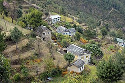
A small settlement near
Kharikhola, Khumbu Pasanglhamu
479:. Solukhumbu was a district out of six districts of
1458:
1358:
1335:
1317:
1228:
1201:
1110:"Everest Travel guide – Solu Khumbu trekking guide"
381:
368:
358:
341:
333:
325:
320:
312:
304:
296:
288:
283:
275:
263:
255:
247:
237:
232:
224:
216:
204:
192:
172:
30:
1601:Rural municipalities of Nepal established in 2017
1092:"खुम्बु पासाङल्हामु गाउँपालिकाको संक्षिप्त परिचय"
1038:"Khumbu Pasanglahmu Rural municipality in Nepal"
1294:
1167:
8:
1606:Rural municipalities in Solukhumbu District
514:, who was first Nepalese woman who climbed
1301:
1287:
1279:
1174:
1160:
1152:
108:
75:
27:
292:1,539.11 km (594.25 sq mi)
276: • Chief Administrative Officer
1086:
1084:
592:
1004:
944:
380:
367:
357:
340:
319:
311:
303:
282:
231:
223:
171:
132:
60:
48:
1596:Rural municipalities in Koshi Province
1064:"744 new local units come into effect"
483:. Sagarmatha was a zone (division) of
332:
324:
295:
287:
274:
262:
254:
246:
236:
215:
203:
191:
7:
471:were all separate local level body (
404:) is one of 7 rural municipalities (
25:Gaunpalika in Province No. 1, Nepal
14:
1219:
983:
971:
959:
947:
179:
107:
100:
74:
67:
50:
1096:www.khumbupasanglhamumun.gov.np
1013:"List of Local bodies of Nepal"
939:Landmarks of Khumbu Pasanglhamu
1:
473:Village development committee
402:खुम्बु पासाङल्हामु गाउँपालिका
308:8,848 m (29,029 ft)
264: • Vice-chairperson
35:खुम्बु पासाङल्हामु गाउँपालिका
1460:Largest Rural municipalities
316:1,900 m (6,200 ft)
783:Mean daily minimum °C (°F)
643:Mean daily maximum °C (°F)
1622:
926:
485:Eastern development region
121:Khumbu Pasanglhamu (Nepal)
91:Show map of Koshi Province
88:Location in Province No. 1
15:
1217:
1189:
852:
782:
712:
642:
637:
634:
631:
628:
625:
622:
619:
616:
613:
610:
607:
604:
601:
598:
401:
279:Mr.Mohan Prasad Chapagain
133:
61:
49:
40:
259:Mr. Mingma Chhiri Sherpa
256: • Chairperson
1337:Sub-metropolitan cities
1114:www.explorehimalaya.com
506:, which name also bear
18:Khumbu (disambiguation)
1360:Largest municipalities
1135:"Climate:Chaurikharka"
337:5.8/km (15/sq mi)
305:Highest elevation
267:Mrs.Tasilhamu Sherpa (
1042:www.citypopulation.de
543:which is situated in
526:Geography and Climate
313:Lowest elevation
1230:Rural Municipalities
334: • Density
16:For other uses, see
1591:Solukhumbu District
1420:Pathari Shanischare
1319:Metropolitan cities
1263:Khumbu Pasang Lhamu
1183:Solukhumbu District
713:Daily mean °C (°F)
595:
573:, Phskding, Manju,
512:Pasang Lhamu Sherpa
504:Solukhumbu District
477:Solukhumbu District
410:Solukhumbu district
211:Solukhumbu District
153: /
1586:Khumbu Pasanglhamu
1309:Municipalities of
1068:The Kathmandu Post
593:
545:Taplejung District
518:, she hailed from
500:Khumbu Pasanglhamu
394:Khumbu Pasanglhamu
326: • Total
289: • Total
115:Khumbu Pasanglhamu
82:Khumbu Pasanglhamu
32:Khumbu Pasanglhamu
1573:
1572:
1276:
1275:
934:
933:
446:2011 Nepal census
391:
390:
297: • Rank
248: • Body
238: • Type
134:Coordinates (
124:Show map of Nepal
1613:
1303:
1296:
1289:
1280:
1223:
1176:
1169:
1162:
1153:
1146:
1145:
1143:
1141:
1131:
1125:
1124:
1122:
1120:
1106:
1100:
1099:
1088:
1079:
1078:
1076:
1074:
1060:
1054:
1053:
1051:
1049:
1044:. 8 October 2017
1034:
1028:
1027:
1025:
1023:
1009:
990:Khumjung Village
987:
975:
966:Mount Ama Dablam
963:
951:
929:Climate-data.org
596:
403:
386:Official website
185:
183:
182:
168:
167:
165:
164:
163:
158:
154:
151:
150:
149:
146:
125:
111:
110:
104:
92:
78:
77:
71:
54:
28:
1621:
1620:
1616:
1615:
1614:
1612:
1611:
1610:
1576:
1575:
1574:
1569:
1462:(by population)
1461:
1454:
1375:Sundar Haraicha
1362:(by population)
1361:
1354:
1331:
1313:
1307:
1277:
1272:
1224:
1215:
1197:
1185:
1180:
1150:
1149:
1139:
1137:
1133:
1132:
1128:
1118:
1116:
1108:
1107:
1103:
1090:
1089:
1082:
1072:
1070:
1062:
1061:
1057:
1047:
1045:
1036:
1035:
1031:
1021:
1019:
1011:
1010:
1006:
1001:
996:
995:
994:
991:
988:
979:
976:
967:
964:
955:
952:
941:
940:
935:
921:
916:
911:
906:
901:
896:
891:
886:
881:
876:
871:
866:
861:
847:
842:
837:
832:
827:
822:
817:
812:
807:
802:
797:
792:
787:
777:
772:
767:
762:
757:
752:
747:
742:
737:
732:
727:
722:
717:
707:
702:
697:
692:
687:
682:
677:
672:
667:
662:
657:
652:
647:
528:
497:
481:Sagarmatha Zone
180:
178:
161:
159:
157:27.74°N 86.73°E
155:
152:
147:
144:
142:
140:
139:
129:
128:
127:
126:
123:
122:
119:
118:
117:
116:
112:
95:
94:
93:
90:
89:
86:
85:
84:
83:
79:
57:
45:
36:
33:
26:
21:
12:
11:
5:
1619:
1617:
1609:
1608:
1603:
1598:
1593:
1588:
1578:
1577:
1571:
1570:
1568:
1567:
1562:
1557:
1552:
1547:
1542:
1537:
1532:
1527:
1522:
1517:
1512:
1507:
1502:
1497:
1492:
1487:
1482:
1477:
1472:
1466:
1464:
1456:
1455:
1453:
1452:
1447:
1442:
1437:
1432:
1427:
1422:
1417:
1412:
1407:
1402:
1397:
1392:
1387:
1382:
1377:
1372:
1366:
1364:
1356:
1355:
1353:
1352:
1347:
1341:
1339:
1333:
1332:
1330:
1329:
1323:
1321:
1315:
1314:
1311:Koshi Province
1308:
1306:
1305:
1298:
1291:
1283:
1274:
1273:
1271:
1270:
1265:
1260:
1255:
1250:
1245:
1240:
1234:
1232:
1226:
1225:
1218:
1216:
1214:
1213:
1207:
1205:
1199:
1198:
1190:
1187:
1186:
1181:
1179:
1178:
1171:
1164:
1156:
1148:
1147:
1126:
1101:
1080:
1055:
1029:
1003:
1002:
1000:
997:
993:
992:
989:
982:
980:
977:
970:
968:
965:
958:
956:
953:
946:
943:
942:
938:
937:
936:
932:
931:
924:
923:
918:
913:
908:
903:
898:
893:
888:
883:
878:
873:
868:
863:
858:
850:
849:
844:
839:
834:
829:
824:
819:
814:
809:
804:
799:
794:
789:
784:
780:
779:
774:
769:
764:
759:
754:
749:
744:
739:
734:
729:
724:
719:
714:
710:
709:
704:
699:
694:
689:
684:
679:
674:
669:
664:
659:
654:
649:
644:
640:
639:
636:
633:
630:
627:
624:
621:
618:
615:
612:
609:
606:
603:
600:
591:
537:Province No. 1
527:
524:
502:is located in
496:
493:
414:Province No. 1
389:
388:
383:
379:
378:
372:
366:
365:
362:
356:
355:
345:
339:
338:
335:
331:
330:
327:
323:
322:
318:
317:
314:
310:
309:
306:
302:
301:
298:
294:
293:
290:
286:
285:
281:
280:
277:
273:
272:
265:
261:
260:
257:
253:
252:
249:
245:
244:
239:
235:
234:
230:
229:
226:
222:
221:
218:
214:
213:
208:
202:
201:
199:Province No. 1
196:
190:
189:
176:
170:
169:
131:
130:
120:
114:
113:
106:
105:
99:
98:
97:
96:
87:
81:
80:
73:
72:
66:
65:
64:
63:
62:
59:
58:
55:
47:
46:
41:
38:
37:
34:
31:
24:
13:
10:
9:
6:
4:
3:
2:
1618:
1607:
1604:
1602:
1599:
1597:
1594:
1592:
1589:
1587:
1584:
1583:
1581:
1566:
1563:
1561:
1558:
1556:
1553:
1551:
1548:
1546:
1543:
1541:
1538:
1536:
1533:
1531:
1528:
1526:
1523:
1521:
1518:
1516:
1513:
1511:
1508:
1506:
1503:
1501:
1498:
1496:
1493:
1491:
1488:
1486:
1483:
1481:
1478:
1476:
1475:Buddha Shanti
1473:
1471:
1468:
1467:
1465:
1463:
1457:
1451:
1448:
1446:
1443:
1441:
1438:
1436:
1433:
1431:
1428:
1426:
1423:
1421:
1418:
1416:
1415:Shivasatakshi
1413:
1411:
1408:
1406:
1403:
1401:
1398:
1396:
1393:
1391:
1388:
1386:
1383:
1381:
1378:
1376:
1373:
1371:
1368:
1367:
1365:
1363:
1357:
1351:
1348:
1346:
1343:
1342:
1340:
1338:
1334:
1328:
1325:
1324:
1322:
1320:
1316:
1312:
1304:
1299:
1297:
1292:
1290:
1285:
1284:
1281:
1269:
1266:
1264:
1261:
1259:
1256:
1254:
1251:
1249:
1246:
1244:
1241:
1239:
1238:Dudhakaushika
1236:
1235:
1233:
1231:
1227:
1222:
1212:
1211:Solududhkunda
1209:
1208:
1206:
1204:
1200:
1196:
1195:
1191:Headquarter:
1188:
1184:
1177:
1172:
1170:
1165:
1163:
1158:
1157:
1154:
1136:
1130:
1127:
1115:
1111:
1105:
1102:
1098:. 5 May 2018.
1097:
1093:
1087:
1085:
1081:
1069:
1065:
1059:
1056:
1043:
1039:
1033:
1030:
1018:
1014:
1008:
1005:
998:
986:
981:
978:Lukla Airport
974:
969:
962:
957:
950:
945:
930:
925:
919:
914:
909:
904:
899:
894:
889:
884:
879:
874:
869:
864:
859:
856:
855:precipitation
851:
845:
840:
835:
830:
825:
820:
815:
810:
805:
800:
795:
790:
785:
781:
775:
770:
765:
760:
755:
750:
745:
740:
735:
730:
725:
720:
715:
711:
705:
700:
695:
690:
685:
680:
675:
670:
665:
660:
655:
650:
645:
641:
597:
590:
586:
584:
580:
576:
572:
568:
564:
560:
556:
552:
548:
546:
542:
538:
535:(by area) of
534:
525:
523:
521:
517:
516:Mount Everest
513:
509:
505:
501:
494:
492:
490:
486:
482:
478:
474:
470:
466:
462:
458:
453:
451:
447:
443:
439:
435:
432:(1,5,7–9 No.
431:
427:
423:
419:
415:
411:
407:
399:
395:
387:
384:
377:
373:
371:
363:
361:
353:
349:
346:
344:
336:
328:
315:
307:
299:
291:
278:
270:
266:
258:
250:
243:
242:Rural council
240:
228:12 March 2017
227:
219:
212:
209:
207:
200:
197:
195:
188:
177:
175:
166:
137:
103:
70:
53:
44:
39:
29:
23:
19:
1243:Necha Salyan
1203:Municipality
1192:
1138:. Retrieved
1129:
1117:. Retrieved
1113:
1104:
1095:
1071:. Retrieved
1058:
1046:. Retrieved
1041:
1032:
1020:. Retrieved
1007:
954:Namche Bazar
928:
857:mm (inches)
587:
549:
541:Phaktanglung
529:
499:
498:
469:Chaurikharka
455:Previously,
454:
450:Chaurikharka
442:Chaurikharka
393:
392:
376:Chaurikharka
162:27.74; 86.73
136:Chaurikharka
22:
1520:Kachankawal
1515:Kanepokhari
1510:Dhanpalthan
1253:Maha Kulung
300:5th (Nepal)
225:Established
160: /
1580:Categories
1540:Barhadashi
1485:Harinagara
1480:Budi Ganga
1400:Arjundhara
1370:Mechinagar
1327:Biratnagar
1268:Likhu Pike
999:References
581:, Khunde,
563:Ama Dablam
533:Gaunpalika
406:Gaunpalika
374:Office of
352:Nepal Time
321:Population
233:Government
43:Gaunpalika
1565:Miklajung
1555:Gaurigunj
1535:Dewangunj
1450:Gauradaha
1445:Ratuwamai
1430:Bhadrapur
1248:Dudhkoshi
583:Tengboche
495:Etymology
360:Area code
343:Time zone
1560:Kerabari
1550:Gramthan
1500:Katahari
1490:Bhokraha
1440:Ramdhuni
1425:Urlabari
1380:Birtamod
1073:15 March
1048:12 March
927:Source:
853:Average
579:Khumjung
522:region.
457:Khumjung
422:Khumjung
348:UTC+5:45
206:District
194:Province
1410:Inaruwa
1405:Belbari
1390:Triyuga
1345:Itahari
1194:Salleri
1140:25 June
1119:26 June
922:(78.1)
902:(11.3)
897:(18.9)
892:(21.9)
887:(11.9)
848:(41.9)
843:(30.6)
838:(35.4)
833:(44.1)
828:(50.4)
823:(52.5)
818:(53.2)
813:(51.6)
808:(46.2)
803:(42.4)
798:(36.7)
793:(31.6)
788:(28.6)
778:(50.8)
773:(40.8)
768:(45.7)
763:(53.2)
758:(57.4)
753:(59.7)
748:(59.7)
738:(55.6)
733:(52.7)
723:(41.2)
718:(38.7)
708:(59.8)
703:(51.3)
698:(55.9)
693:(62.4)
688:(64.6)
683:(66.9)
678:(66.4)
673:(66.4)
668:(65.1)
663:(63.1)
658:(56.3)
653:(50.9)
648:(48.7)
559:Cho Oyu
382:Website
364:+977-38
174:Country
148:86°44′E
145:27°44′N
1505:Jahada
1435:Duhabi
1395:Baraha
1350:Dharan
1258:Sotang
1022:2 June
1017:MoFALD
917:(0.4)
912:(0.5)
907:(3.5)
882:(4.2)
877:(2.4)
872:(1.3)
867:(1.2)
862:(0.6)
599:Month
575:Namche
567:Pumori
555:Nuptse
551:Lhotse
539:after
520:Khumbu
508:Khumbu
465:Jubing
461:Namche
440:) and
438:Jubing
430:Jubing
428:&
426:Namche
398:Nepali
184:
1545:Barju
1530:Jhapa
1525:Gadhi
1495:Koshi
1470:Kamal
1385:Damak
920:1,982
743:(59)
728:(46)
638:Year
571:Lukla
489:Nepal
475:) of
434:Wards
418:Nepal
408:) in
329:8,989
217:Wards
187:Nepal
1142:2018
1121:2018
1075:2017
1050:2018
1024:2017
841:−0.8
826:10.2
821:11.4
816:11.8
811:10.9
791:−0.2
786:−1.9
776:10.5
761:11.8
756:14.1
751:15.4
746:15.4
736:13.1
731:11.5
706:15.5
701:10.7
696:13.3
691:16.9
686:18.1
681:19.4
676:19.1
671:19.1
666:18.4
661:17.3
656:13.5
651:10.5
635:Dec
632:Nov
629:Oct
626:Sep
623:Aug
620:Jul
617:Jun
614:May
611:Apr
608:Mar
605:Feb
602:Jan
467:and
284:Area
900:288
895:479
890:555
885:301
880:107
846:5.5
836:1.9
831:6.7
806:7.9
801:5.8
796:2.6
771:4.9
766:7.6
721:5.1
716:3.7
646:9.3
487:of
436:of
416:of
412:of
269:NCP
138:):
1582::
1112:.
1094:.
1083:^
1066:.
1040:.
1015:.
915:10
910:12
905:90
875:60
870:34
865:30
860:16
741:15
577:,
565:,
561:,
557:,
553:,
547:.
491:.
463:,
459:,
452:.
424:,
420:.
400::
370:HQ
1302:e
1295:t
1288:v
1175:e
1168:t
1161:v
1144:.
1123:.
1077:.
1052:.
1026:.
726:8
396:(
354:)
350:(
271:)
220:5
20:.
Text is available under the Creative Commons Attribution-ShareAlike License. Additional terms may apply.