54:
586:
79:
115:
42:
122:
86:
53:
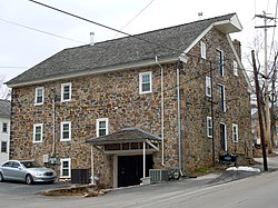
339:, Kimberton developed around a tavern; in this case, the tavern was called Chrisman's. In 1796, the Chrisman's Mill began operating, drawing activity to the tiny village. It operated until 1938 and is currently the town's post office.
1580:
418:
922:
727:
524:
1585:
465:
443:
807:
857:
692:
867:
852:
782:
777:
902:
892:
1527:
837:
150:
78:
1299:
772:
517:
1099:
114:
1385:
1144:
1314:
932:
737:
1345:
1319:
1149:
942:
912:
747:
712:
962:
862:
832:
797:
762:
510:
422:
952:
947:
937:
907:
882:
752:
742:
722:
707:
312:
211:
350:
957:
877:
812:
802:
757:
41:
927:
787:
732:
702:
977:
872:
822:
817:
1229:
1089:
917:
842:
717:
567:
394:
248:
502:
1219:
1189:
972:
847:
767:
659:
1430:
897:
887:
792:
1204:
1129:
827:
1476:
1405:
1400:
629:
534:
402:
316:
292:
201:
59:
1550:
1420:
1330:
1169:
1124:
697:
1491:
1450:
1445:
1390:
1365:
1350:
1284:
1209:
1139:
1038:
1028:
1017:
669:
654:
556:
1512:
1435:
1425:
1325:
1309:
1274:
1264:
1254:
1174:
1011:
664:
624:
614:
575:
1522:
1465:
1460:
1415:
1375:
1370:
1289:
1234:
1194:
1179:
1104:
1079:
674:
649:
287:
335:
Originally settled during the late 18th it remained unnamed until 1817. Like many surrounding villages in the
1005:
1496:
1481:
1470:
1340:
1294:
1259:
1134:
1094:
1064:
1049:
987:
684:
308:
32:
1517:
1440:
1304:
1269:
1184:
1119:
1069:
619:
609:
596:
1501:
1455:
1410:
1335:
1279:
1244:
1239:
1214:
1199:
1114:
1022:
634:
390:
269:
1557:
1486:
1380:
1360:
1355:
1249:
1224:
1059:
995:
644:
639:
604:
397:
258:
1506:
1159:
1109:
1074:
1054:
1044:
1033:
304:
1000:
1395:
1541:‡This populated place also has portions in an adjacent county or counties †Former borough
408:
1574:
414:
336:
320:
99:
63:
549:
365:
352:
165:
152:
239:
324:
492:
265:
244:
482:
506:
497:
584:
487:
1581:
Unincorporated communities in
Chester County, Pennsylvania
18:
1536:
1158:
986:
683:
595:
566:
286:
276:
255:
238:
230:
225:
217:
207:
197:
189:
181:
23:
378:(40.130N, -75.572W). The elevation is 207 feet.
121:
85:
518:
8:
381:In 2020, Kimberton had a population of 568.
411:, artist, educator, and spirituality author
134:Kimberton, Pennsylvania (the United States)
1586:Unincorporated communities in Pennsylvania
525:
511:
503:
20:
435:
275:
237:
224:
216:
180:
145:
70:
50:
38:
423:University of Pennsylvania Law School
285:
254:
229:
206:
196:
188:
7:
46:Chrisman's Mill, now the post office
533:Municipalities and communities of
14:
405:, educator, reformer, and author
120:
113:
84:
77:
52:
40:
62:(top) and of Chester County in
468:. United States Census Bureau.
1:
446:. United States Census Bureau
137:Show map of the United States
536:Chester County, Pennsylvania
403:Esther J. Trimble Lippincott
337:Commonwealth of Pennsylvania
60:Chester County, Pennsylvania
1602:
343:Geography and demographics
1546:
582:
547:
146:
98:Location of Kimberton in
71:
58:Location of Kimberton in
51:
39:
30:
488:Kimberton Waldorf School
347:Kimberton is located at
305:unincorporated community
104:Show map of Pennsylvania
466:"Census Population API"
444:"Census Population API"
395:United States President
309:census-designated place
221:207 ft (63 m)
128:Kimberton, Pennsylvania
92:Kimberton, Pennsylvania
33:Census-designated place
25:Kimberton, Pennsylvania
589:
483:Kimberton Fire Company
313:East Pikeland Township
588:
493:Kimberton Whole Foods
419:Supreme Court justice
391:John S. D. Eisenhower
366:40.13056°N 75.57222°W
323:, United States. The
257: • Summer (
166:40.13056°N 75.57222°W
1559:United States portal
398:Dwight D. Eisenhower
1552:Pennsylvania portal
371:40.13056; -75.57222
362: /
311:that is located in
171:40.13056; -75.57222
162: /
1230:Darlington Corners
1090:Lincoln University
1023:Cheyney University
590:
231: • Total
1568:
1567:
660:South Coatesville
298:
297:
1593:
1560:
1553:
1431:Nantmeal Village
1396:Longwood Gardens
933:West Marlborough
923:West Fallowfield
738:East Marlborough
728:East Fallowfield
587:
559:
552:
542:
537:
527:
520:
513:
504:
470:
469:
462:
456:
455:
453:
451:
440:
393:, son of former
377:
376:
374:
373:
372:
367:
363:
360:
359:
358:
355:
262:
177:
176:
174:
173:
172:
167:
163:
160:
159:
158:
155:
138:
124:
123:
117:
105:
88:
87:
81:
56:
44:
21:
1601:
1600:
1596:
1595:
1594:
1592:
1591:
1590:
1571:
1570:
1569:
1564:
1558:
1551:
1542:
1532:
1205:Chester Springs
1161:
1154:
1130:South Pottstown
982:
943:West Nottingham
913:West Brandywine
748:East Nottingham
713:East Brandywine
679:
591:
585:
580:
562:
557:
550:
543:
540:
535:
531:
479:
474:
473:
464:
463:
459:
449:
447:
442:
441:
437:
432:
387:
370:
368:
364:
361:
356:
353:
351:
349:
348:
345:
333:
282:
256:
170:
168:
164:
161:
156:
153:
151:
149:
148:
142:
141:
140:
139:
136:
135:
132:
131:
130:
129:
125:
108:
107:
106:
103:
102:
96:
95:
94:
93:
89:
67:
47:
35:
26:
19:
12:
11:
5:
1599:
1597:
1589:
1588:
1583:
1573:
1572:
1566:
1565:
1563:
1562:
1555:
1547:
1544:
1543:
1540:
1538:
1534:
1533:
1531:
1530:
1528:Yellow Springs
1525:
1520:
1515:
1510:
1504:
1499:
1494:
1489:
1484:
1479:
1477:Strickersville
1474:
1468:
1463:
1458:
1453:
1448:
1443:
1438:
1433:
1428:
1423:
1418:
1413:
1408:
1406:Ludwigs Corner
1403:
1401:Lower Hopewell
1398:
1393:
1388:
1383:
1378:
1373:
1368:
1363:
1358:
1353:
1348:
1343:
1338:
1333:
1328:
1323:
1317:
1312:
1307:
1302:
1297:
1292:
1287:
1282:
1277:
1272:
1267:
1262:
1257:
1252:
1247:
1242:
1237:
1232:
1227:
1222:
1217:
1212:
1207:
1202:
1197:
1192:
1187:
1182:
1177:
1172:
1166:
1164:
1156:
1155:
1153:
1152:
1147:
1142:
1137:
1132:
1127:
1122:
1117:
1112:
1107:
1102:
1097:
1092:
1087:
1082:
1077:
1072:
1067:
1062:
1057:
1052:
1047:
1042:
1036:
1031:
1026:
1020:
1015:
1009:
1003:
998:
992:
990:
984:
983:
981:
980:
975:
970:
969:
968:
963:West Whiteland
960:
955:
950:
945:
940:
935:
930:
925:
920:
915:
910:
905:
900:
895:
890:
885:
880:
875:
870:
865:
863:South Coventry
860:
855:
850:
845:
840:
835:
833:North Coventry
830:
825:
820:
815:
810:
805:
800:
798:London Britain
795:
790:
785:
780:
775:
770:
765:
763:East Whiteland
760:
755:
750:
745:
740:
735:
730:
725:
720:
715:
710:
705:
700:
695:
689:
687:
681:
680:
678:
677:
672:
667:
662:
657:
652:
647:
642:
637:
632:
630:Kennett Square
627:
622:
617:
612:
607:
601:
599:
593:
592:
583:
581:
579:
578:
572:
570:
564:
563:
548:
545:
544:
532:
530:
529:
522:
515:
507:
501:
500:
495:
490:
485:
478:
477:External links
475:
472:
471:
457:
434:
433:
431:
428:
427:
426:
412:
409:M. C. Richards
406:
400:
386:
385:Notable people
383:
344:
341:
332:
329:
317:Chester County
296:
295:
290:
284:
283:
280:
278:
274:
273:
263:
253:
252:
242:
236:
235:
232:
228:
227:
223:
222:
219:
215:
214:
209:
205:
204:
199:
195:
194:
191:
187:
186:
183:
179:
178:
144:
143:
133:
127:
126:
119:
118:
112:
111:
110:
109:
97:
91:
90:
83:
82:
76:
75:
74:
73:
72:
69:
68:
57:
49:
48:
45:
37:
36:
31:
28:
27:
24:
17:
13:
10:
9:
6:
4:
3:
2:
1598:
1587:
1584:
1582:
1579:
1578:
1576:
1561:
1556:
1554:
1549:
1548:
1545:
1539:
1535:
1529:
1526:
1524:
1521:
1519:
1516:
1514:
1511:
1508:
1505:
1503:
1500:
1498:
1495:
1493:
1490:
1488:
1485:
1483:
1480:
1478:
1475:
1472:
1469:
1467:
1464:
1462:
1459:
1457:
1454:
1452:
1449:
1447:
1444:
1442:
1439:
1437:
1434:
1432:
1429:
1427:
1424:
1422:
1421:Milford Mills
1419:
1417:
1414:
1412:
1409:
1407:
1404:
1402:
1399:
1397:
1394:
1392:
1389:
1387:
1384:
1382:
1379:
1377:
1374:
1372:
1369:
1367:
1364:
1362:
1359:
1357:
1354:
1352:
1349:
1347:
1344:
1342:
1339:
1337:
1334:
1332:
1331:Humphreyville
1329:
1327:
1324:
1321:
1318:
1316:
1313:
1311:
1308:
1306:
1303:
1301:
1298:
1296:
1293:
1291:
1288:
1286:
1283:
1281:
1278:
1276:
1273:
1271:
1268:
1266:
1263:
1261:
1258:
1256:
1253:
1251:
1248:
1246:
1243:
1241:
1238:
1236:
1233:
1231:
1228:
1226:
1223:
1221:
1220:Coventryville
1218:
1216:
1213:
1211:
1208:
1206:
1203:
1201:
1198:
1196:
1193:
1191:
1190:Byers Station
1188:
1186:
1183:
1181:
1178:
1176:
1173:
1171:
1170:Birchrunville
1168:
1167:
1165:
1163:
1157:
1151:
1148:
1146:
1143:
1141:
1138:
1136:
1133:
1131:
1128:
1126:
1125:Sadsburyville
1123:
1121:
1118:
1116:
1113:
1111:
1108:
1106:
1103:
1101:
1098:
1096:
1093:
1091:
1088:
1086:
1083:
1081:
1078:
1076:
1073:
1071:
1068:
1066:
1063:
1061:
1058:
1056:
1053:
1051:
1048:
1046:
1043:
1040:
1037:
1035:
1032:
1030:
1027:
1024:
1021:
1019:
1016:
1013:
1010:
1007:
1004:
1002:
999:
997:
994:
993:
991:
989:
985:
979:
976:
974:
971:
966:
965:
964:
961:
959:
956:
954:
953:West Sadsbury
951:
949:
948:West Pikeland
946:
944:
941:
939:
938:West Nantmeal
936:
934:
931:
929:
926:
924:
921:
919:
916:
914:
911:
909:
908:West Bradford
906:
904:
901:
899:
896:
894:
891:
889:
886:
884:
883:Upper Uwchlan
881:
879:
876:
874:
871:
869:
866:
864:
861:
859:
856:
854:
851:
849:
846:
844:
841:
839:
836:
834:
831:
829:
826:
824:
821:
819:
816:
814:
811:
809:
806:
804:
801:
799:
796:
794:
791:
789:
786:
784:
781:
779:
776:
774:
771:
769:
766:
764:
761:
759:
756:
754:
753:East Pikeland
751:
749:
746:
744:
743:East Nantmeal
741:
739:
736:
734:
731:
729:
726:
724:
723:East Coventry
721:
719:
716:
714:
711:
709:
708:East Bradford
706:
704:
701:
699:
696:
694:
691:
690:
688:
686:
682:
676:
673:
671:
668:
666:
663:
661:
658:
656:
653:
651:
648:
646:
643:
641:
638:
636:
633:
631:
628:
626:
623:
621:
618:
616:
613:
611:
608:
606:
603:
602:
600:
598:
594:
577:
574:
573:
571:
569:
565:
561:
560:
553:
546:
541:United States
538:
528:
523:
521:
516:
514:
509:
508:
505:
499:
498:Kimberton CSA
496:
494:
491:
489:
486:
484:
481:
480:
476:
467:
461:
458:
445:
439:
436:
429:
424:
420:
416:
413:
410:
407:
404:
401:
399:
396:
392:
389:
388:
384:
382:
379:
375:
342:
340:
338:
330:
328:
326:
322:
318:
314:
310:
306:
302:
294:
291:
289:
279:
271:
267:
264:
260:
250:
246:
243:
241:
233:
220:
213:
212:East Pikeland
210:
203:
200:
192:
185:United States
184:
175:
147:Coordinates:
116:
101:
80:
65:
61:
55:
43:
34:
29:
22:
16:
1492:Valley Forge
1446:Russellville
1391:London Grove
1366:Kemblesville
1351:Jennersville
1300:Hickory Hill
1285:Harmonyville
1210:Chesterville
1140:Toughkenamon
1084:
1039:Dilworthtown
1029:Cochranville
1018:Chesterbrook
958:West Vincent
878:Upper Oxford
813:Lower Oxford
803:London Grove
758:East Vincent
670:West Chester
655:Phoenixville
558:West Chester
555:
460:
448:. Retrieved
438:
415:Owen Roberts
380:
346:
334:
321:Pennsylvania
300:
299:
288:Area code(s)
193:Pennsylvania
100:Pennsylvania
64:Pennsylvania
15:
1513:West Goshen
1436:Parker Ford
1426:Mortonville
1326:Howellville
1310:Hinsonville
1275:Goshenville
1265:Faggs Manor
1255:Embreeville
1175:Black Horse
1162:communities
1100:Marshallton
1012:Chadds Ford
928:West Goshen
808:Londonderry
788:Honey Brook
733:East Goshen
703:Charlestown
665:Spring City
625:Honey Brook
615:Downingtown
576:Coatesville
551:County seat
450:October 12,
369: /
169: /
1575:Categories
1523:Willowdale
1466:Steelville
1461:Springdell
1451:St. Peters
1416:Mendenhall
1386:Lewisville
1376:Landenberg
1371:Knauertown
1290:Hayesville
1235:Daylesford
1195:Cedarville
1180:Brandamore
1145:Unionville
1105:Nottingham
1080:Kenilworth
978:Willistown
873:Tredyffrin
858:Schuylkill
823:New London
818:New Garden
693:Birmingham
675:West Grove
650:Parkesburg
430:References
357:75°34′20″W
354:40°07′50″N
327:is 19442.
226:Population
157:75°34′20″W
154:40°07′50″N
1537:Footnotes
1497:Wagontown
1482:Sugartown
1471:Strafford
1341:Ironsides
1315:Homeville
1295:Hephzibah
1260:Ercildoun
1135:Thorndale
1095:Lionville
1085:Kimberton
1065:Glenmoore
1050:Eagleview
1006:Cambridge
918:West Caln
868:Thornbury
843:Pennsbury
718:East Caln
685:Townships
301:Kimberton
240:Time zone
218:Elevation
1518:Whitford
1441:Pocopson
1346:Isabella
1320:Hopewell
1305:Hiestand
1270:Glenloch
1185:Bucktown
1150:Westwood
1120:Pughtown
1070:Hamorton
973:Westtown
967:Morstein
853:Sadsbury
848:Pocopson
783:Highland
778:Franklin
768:Easttown
620:Elverson
610:Avondale
597:Boroughs
325:Zip Code
277:ZIP Code
208:Township
1502:Warwick
1456:Siousca
1411:Lyndell
1336:Icedale
1280:Hallman
1245:Doe Run
1240:Devault
1215:Compass
1200:Chatham
1115:Pomeroy
903:Warwick
898:Wallace
888:Uwchlan
793:Kennett
635:Malvern
331:History
202:Chester
182:Country
66:(below)
1487:Suplee
1381:Lenape
1361:Kelton
1356:Kaolin
1250:Dorlan
1225:Cromby
1060:Frazer
996:Berwyn
893:Valley
828:Newlin
645:Oxford
640:Modena
605:Atglen
303:is an
198:County
1507:Wayne
1160:Other
1110:Paoli
1075:Hayti
1055:Exton
1045:Eagle
1034:Devon
281:19442
266:UTC-4
245:UTC-5
190:State
1001:Caln
988:CDPs
838:Penn
698:Caln
568:City
452:2022
425:dean
421:and
307:and
773:Elk
315:in
293:610
270:EDT
259:DST
249:EST
234:568
1577::
554::
539:,
417:,
319:,
1509:‡
1473:‡
1322:†
1041:‡
1025:‡
1014:‡
1008:‡
526:e
519:t
512:v
454:.
272:)
268:(
261:)
251:)
247:(
Text is available under the Creative Commons Attribution-ShareAlike License. Additional terms may apply.