57:
379:
738:
686:
304:
935:
870:
733:
609:
332:
314:
278:
243:
211:
39:
254:
232:
78:
64:
534:
King
Georges Road was re-gazetted to become part of Main Road 200 (continuing north along Wiley Avenue, Roberts Road, Centenary and Homebush Bay Drives), subsuming the southern half of Main Road 315 (its northern half along Punchbowl Road, was made part of Main Road 549, and from Stathfield along The
526:
who had died the previous
February. The southern end of Main Road 315 between Hurstville and Blakeville was later re-aligned to follow the entire length of King Georges Road (and terminate at Princes Highway some distance south than its previous intersection at Woniora Road) on 11 November 1964.
1047:
An Act to amend the Main Roads Act, 1924-1927; to confer certain further powers upon the Main Roads Board; to amend the Local
Government Act, 1919, and certain other Acts; to validate certain payments and other matters; and for purposes connected
530:
King
Georges Road was initially designated to become part of a major north–south metropolitan arterial route in 1964, when the route incorporating other existing local arterial roads from Mona Vale to Blakehurst were designated Ring Road 3.
1212:
1188:
An Act to make provision with respect to the roads of New South Wales; to repeal the State Roads Act 1986, the Crown and Other Roads Act 1990 and certain other enactments; and for other purposes.
1325:
1269:
542:
updated road classifications and the way they could be declared within New South Wales. Under this act, King
Georges Road retains its declaration as part of Main Road 200.
963:
467:). Main Road 315 was declared on 19 February 1929, from the intersection with Wiley Avenue and Punchbowl Road along Wiley Avenue, Canary Road and Belmore Road to
1219:
138:
105:
1025:
An Act to provide for the better construction, maintenance, and financing of main roads; to provide for developmental roads; to constitute a Main Roads Board
56:
1318:
839:
1191:
1028:
479:, and continuing north along Punchbowl Road, The Boulevarde, Concord Road, to Great Western Highway in Strathfield); with the passing of the
545:
King
Georges Road was allocated part of Ring Road 3 in 1964, before it was replaced with State Route 33 in 1974, then re-designated part of
1311:
1051:
639:
1637:
1282:
1164:
1118:
1088:
1001:
720:
499:
483:
to provide for additional declarations of State
Highways and Trunk Roads, this was amended to Main Road 315 on 8 April 1929.
432:
362:
456:
1602:
1541:
1277:
710:
582:
96:
1531:
885:
859:
847:
806:
701:
668:
648:
620:
595:
511:
476:
468:
440:
416:
370:
342:
288:
1356:
881:
823:
802:
789:
749:
697:
693:
672:
635:
624:
616:
587:
549:
3 in April 1993. With the conversion to the newer alphanumeric system in 2013, Metroad 3 was replaced by route A3.
503:
424:
366:
358:
1521:
745:
435:, the road narrows to a four-lane, single-carriageway road before eventually terminating at an intersection with
1793:
1486:
1481:
1426:
1406:
877:
819:
591:
519:
1401:
1366:
939:
793:
774:
1551:
1411:
1376:
1139:
660:
1762:
1737:
1642:
1536:
1501:
1491:
1461:
1431:
1371:
1361:
1185:
762:
714:
459:
provided for the declaration of Main Roads, roads partially funded by the State government through the
1244:
1747:
1682:
1627:
1572:
1416:
741:
428:
317:
1022:
378:
1702:
1692:
1577:
1556:
1526:
1506:
1476:
1471:
1466:
1717:
1652:
1612:
1456:
1386:
1303:
1752:
1677:
1657:
1632:
1396:
1208:
464:
38:
1044:
1757:
1732:
1707:
1667:
1446:
1436:
1381:
460:
934:
1727:
1712:
1587:
1441:
1391:
1339:
1195:
1055:
1032:
873:
472:
436:
336:
29:
522:
and
Princes Highway in Blakehurst on 24 September 1952, presumably in honour of the late
395:
is a 9.0-kilometre-long (5.6 mi) major suburban arterial road through south-western
1722:
1687:
1672:
1647:
1617:
1607:
1592:
1546:
1511:
1348:
1156:
1110:
1080:
993:
753:
523:
194:
415:
King
Georges Road commences at the intersection of Wiley Avenue and Punchbowl Road in
1787:
1772:
1697:
1582:
1451:
419:
and heads in a southeasterly direction as a six-lane, dual-carriageway road, meeting
1767:
1662:
1496:
914:
689:
420:
307:
204:
253:
1622:
1516:
1421:
968:
612:
404:
387:
282:
1163:. No. 7. National Library of Australia. 22 January 1993. pp. 223–30.
1117:. No. 140. National Library of Australia. 11 December 1964. p. 4007.
1597:
1087:. No. 215. National Library of Australia. 17 October 1952. p. 3718.
153:
140:
120:
107:
1742:
903:
400:
1000:. No. 37. National Library of Australia. 15 March 1929. p. 1275.
546:
535:
Boulevard, was replaced by part of Main Road 668), on 22 January 1993.
1335:
396:
1307:
1213:"Schedule of Classified Roads and Unclassified Regional Roads"
867:
606:
730:
1070:, First edition, 1934. The Australia Guide Book Co. Ltd.
1281:. Government of New South Wales. 2012. Archived from
1565:
1347:
354:
349:
326:
295:
272:
267:
221:
203:
193:
185:
177:
172:
95:
23:
1161:Government Gazette of the State of New South Wales
1115:Government Gazette of the State of New South Wales
1085:Government Gazette of the State of New South Wales
998:Government Gazette of the State of New South Wales
889:
628:
471:(and continuing south along Woniora Road to meet
1068:Gregory's Street Directory of Sydney and Suburbs
1218:. Government of New South Wales. Archived from
757:
1319:
988:
986:
560:
8:
490:between Punchbowl Road and Canterbury Road,
629:Route A3 continues north along Wiley Avenue
494:between Canterbury Road and Beverly Hills,
1326:
1312:
1304:
556:
37:
20:
377:
958:
956:
954:
950:
890:Southern terminus of road and route A3
1270:"Road number and name changes in NSW"
857:
851:
837:
831:
817:
811:
787:
781:
772:
766:
724:
683:
677:
658:
652:
633:
600:
77:
63:
7:
481:Main Roads (Amendment) Act of 1929
403:. It is a constituent part of the
14:
933:
868:
736:
731:
684:
607:
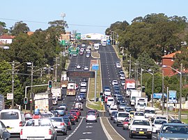
382:King Georges Road, Beverly Hills
330:
312:
302:
276:
252:
241:
230:
209:
76:
62:
55:
1167:from the original on 4 May 2023
1121:from the original on 4 May 2023
1091:from the original on 4 May 2023
1004:from the original on 4 May 2023
1:
1278:Roads & Maritime Services
788:Stoney Creek Road –
457:Parliament of New South Wales
1603:Burnt Bridge Creek Deviation
518:, between Punchbowl Road in
46:King Georges Road, Roselands
1111:"Main Roads Act, 1924-1963"
1081:"Main Roads Act, 1924-1951"
994:"Main Roads Act, 1924-1927"
940:Australian Roads portal
1810:
1186:State of New South Wales,
1045:State of New South Wales,
1023:State of New South Wales,
634:Punchbowl Road –
385:
1146:. Retrieved 16 June 2013.
894:
863:
858:Stuart Street –
854:
846:
834:
827:
814:
801:
797:
784:
769:
761:
727:
719:
709:
705:
680:
667:
655:
647:
643:
603:
586:
581:
576:
573:
570:
567:
564:
559:
189:9.0 km (5.6 mi)
50:
45:
36:
16:Road in Sydney, Australia
910:
899:
840:South Coast railway line
154:33.987885°S 151.111722°E
121:33.917494°S 151.065112°E
818:Forest Road –
775:East Hills railway line
1194:11 August 2022 at the
1054:12 August 2022 at the
1031:11 August 2022 at the
661:Bankstown railway line
510:between Penshurst and
453:Main Roads Act of 1924
383:
159:-33.987885; 151.111722
126:-33.917494; 151.065112
1643:Great Western Highway
381:
1748:Southern Cross Drive
1628:General Holmes Drive
711:Canterbury-Bankstown
583:Canterbury-Bankstown
486:Previously known as
166: (Southeast end)
133: (Northwest end)
1703:Old South Head Road
1693:New South Head Road
1245:"Metroad 3 History"
964:"King Georges Road"
553:Major intersections
538:The passing of the
451:The passing of the
173:General information
150: /
117: /
1718:Pennant Hills Road
1653:Henry Lawson Drive
1613:Cumberland Highway
1387:Castlereagh Street
384:
343:Blakehurst, Sydney
289:Wiley Park, Sydney
1781:
1780:
1753:Syd Einfeld Drive
1678:King Georges Road
1658:The Horsley Drive
1633:Gore Hill Freeway
1225:on 25 August 2022
1209:Transport for NSW
1157:"State Roads Act"
925:
924:
692:(A34) –
640:Strathfield South
540:Roads Act of 1993
516:King Georges Road
514:, it was renamed
465:Transport for NSW
427:. After crossing
393:King Georges Road
376:
375:
25:King Georges Road
1801:
1758:Taren Point Road
1733:Prospect Highway
1708:Old Windsor Road
1668:James Ruse Drive
1638:Great North Road
1487:Macquarie Street
1482:Liverpool Street
1447:Grosvenor Street
1437:Glebe Point Road
1427:Elizabeth Street
1407:Cleveland Street
1328:
1321:
1314:
1305:
1298:
1297:
1295:
1293:
1288:on 25 March 2016
1287:
1274:
1266:
1260:
1259:
1257:
1255:
1241:
1235:
1234:
1232:
1230:
1224:
1217:
1205:
1199:
1198:10 November 1924
1183:
1177:
1176:
1174:
1172:
1153:
1147:
1140:Sydney Ring Road
1137:
1131:
1130:
1128:
1126:
1107:
1101:
1100:
1098:
1096:
1077:
1071:
1065:
1059:
1042:
1036:
1035:10 November 1924
1020:
1014:
1013:
1011:
1009:
990:
981:
980:
978:
976:
960:
938:
937:
918:
911:
906:
900:
876:(A1) –
872:
871:
744:(M5) –
740:
739:
735:
734:
688:
687:
611:
610:
562:
557:
461:Main Roads Board
345:
334:
333:
316:
315:
306:
305:
291:
280:
279:
260:
256:
249:
245:
244:
238:
234:
233:
217:
213:
212:
165:
164:
162:
161:
160:
155:
151:
148:
147:
146:
143:
132:
131:
129:
128:
127:
122:
118:
115:
114:
113:
110:
80:
79:
66:
65:
59:
41:
21:
1809:
1808:
1804:
1803:
1802:
1800:
1799:
1798:
1794:Sydney Metroads
1784:
1783:
1782:
1777:
1728:Princes Highway
1713:Parramatta Road
1588:Barrenjoey Road
1561:
1542:Victoria Street
1442:Goulburn Street
1402:Clarence Street
1392:Chalmers Street
1367:Bathurst Street
1343:
1340:New South Wales
1332:
1302:
1301:
1291:
1289:
1285:
1272:
1268:
1267:
1263:
1253:
1251:
1243:
1242:
1238:
1228:
1226:
1222:
1215:
1211:(August 2022).
1207:
1206:
1202:
1196:Wayback Machine
1184:
1180:
1170:
1168:
1155:
1154:
1150:
1138:
1134:
1124:
1122:
1109:
1108:
1104:
1094:
1092:
1079:
1078:
1074:
1066:
1062:
1056:Wayback Machine
1043:
1039:
1033:Wayback Machine
1021:
1017:
1007:
1005:
992:
991:
984:
974:
972:
962:
961:
952:
947:
932:
930:
921:
913:
909:
902:
898:
874:Princes Highway
869:
737:
732:
690:Canterbury Road
685:
608:
555:
473:Princes Highway
449:
437:Princes Highway
421:Canterbury Road
413:
390:
341:
340:
337:Princes Highway
331:
322:
313:
308:Canterbury Road
303:
287:
286:
277:
268:Major junctions
263:
258:
247:
246:State Route 33
242:
236:
231:
223:
215:
210:
205:Route number(s)
158:
156:
152:
149:
144:
141:
139:
137:
136:
125:
123:
119:
116:
111:
108:
106:
104:
103:
91:
90:
89:
88:
87:
86:
85:
81:
73:
72:
71:
67:
32:
30:New South Wales
27:
26:
17:
12:
11:
5:
1807:
1805:
1797:
1796:
1786:
1785:
1779:
1778:
1776:
1775:
1770:
1765:
1760:
1755:
1750:
1745:
1740:
1735:
1730:
1725:
1723:Pittwater Road
1720:
1715:
1710:
1705:
1700:
1695:
1690:
1688:Lane Cove Road
1685:
1680:
1675:
1673:Jeffrey Street
1670:
1665:
1660:
1655:
1650:
1648:Heathcote Road
1645:
1640:
1635:
1630:
1625:
1620:
1618:Darling Street
1615:
1610:
1608:City West Link
1605:
1600:
1595:
1593:Blacktown Road
1590:
1585:
1580:
1575:
1569:
1567:
1566:Suburban roads
1563:
1562:
1560:
1559:
1554:
1552:William Street
1549:
1547:Whitlam Square
1544:
1539:
1534:
1532:Stanley Street
1529:
1524:
1522:Queen's Square
1519:
1514:
1512:Phillip Street
1509:
1504:
1499:
1494:
1489:
1484:
1479:
1474:
1469:
1464:
1459:
1454:
1449:
1444:
1439:
1434:
1429:
1424:
1419:
1414:
1412:College Street
1409:
1404:
1399:
1394:
1389:
1384:
1379:
1377:Bayswater Road
1374:
1369:
1364:
1359:
1353:
1351:
1349:City of Sydney
1345:
1344:
1333:
1331:
1330:
1323:
1316:
1308:
1300:
1299:
1261:
1236:
1200:
1178:
1148:
1132:
1102:
1072:
1060:
1037:
1015:
982:
949:
948:
946:
943:
929:
926:
923:
922:
920:
919:
907:
895:
892:
891:
888:
865:
864:
862:
856:
853:
850:
844:
843:
836:
833:
829:
828:
826:
816:
813:
810:
799:
798:
796:
786:
783:
779:
778:
771:
768:
765:
759:
758:
756:
754:Sydney Airport
729:
726:
723:
718:
707:
706:
704:
682:
679:
676:
665:
664:
657:
654:
651:
645:
644:
642:
631:
630:
627:
605:
602:
599:
585:
579:
578:
575:
572:
569:
566:
563:
554:
551:
524:King George VI
496:Dumbleton Road
448:
445:
412:
409:
386:Main article:
374:
373:
356:
352:
351:
347:
346:
328:
324:
323:
321:
320:
310:
299:
297:
293:
292:
274:
270:
269:
265:
264:
262:
261:
250:
239:
227:
225:
219:
218:
216:(2013–present)
207:
201:
200:
197:
191:
190:
187:
183:
182:
179:
175:
174:
170:
169:
168:
167:
134:
99:
93:
92:
83:
82:
75:
74:
69:
68:
61:
60:
54:
53:
52:
51:
48:
47:
43:
42:
34:
33:
28:
24:
15:
13:
10:
9:
6:
4:
3:
2:
1806:
1795:
1792:
1791:
1789:
1774:
1773:Wolseley Road
1771:
1769:
1766:
1764:
1763:Victoria Road
1761:
1759:
1756:
1754:
1751:
1749:
1746:
1744:
1741:
1739:
1738:Richmond Road
1736:
1734:
1731:
1729:
1726:
1724:
1721:
1719:
1716:
1714:
1711:
1709:
1706:
1704:
1701:
1699:
1698:Norton Street
1696:
1694:
1691:
1689:
1686:
1684:
1681:
1679:
1676:
1674:
1671:
1669:
1666:
1664:
1661:
1659:
1656:
1654:
1651:
1649:
1646:
1644:
1641:
1639:
1636:
1634:
1631:
1629:
1626:
1624:
1621:
1619:
1616:
1614:
1611:
1609:
1606:
1604:
1601:
1599:
1596:
1594:
1591:
1589:
1586:
1584:
1583:Bangor Bypass
1581:
1579:
1576:
1574:
1571:
1570:
1568:
1564:
1558:
1555:
1553:
1550:
1548:
1545:
1543:
1540:
1538:
1537:Sussex Street
1535:
1533:
1530:
1528:
1525:
1523:
1520:
1518:
1515:
1513:
1510:
1508:
1505:
1503:
1502:Oxford Street
1500:
1498:
1495:
1493:
1492:Market Street
1490:
1488:
1485:
1483:
1480:
1478:
1475:
1473:
1470:
1468:
1465:
1463:
1462:Hunter Street
1460:
1458:
1455:
1453:
1452:Harris Street
1450:
1448:
1445:
1443:
1440:
1438:
1435:
1433:
1432:George Street
1430:
1428:
1425:
1423:
1420:
1418:
1415:
1413:
1410:
1408:
1405:
1403:
1400:
1398:
1395:
1393:
1390:
1388:
1385:
1383:
1380:
1378:
1375:
1373:
1372:Bridge Street
1370:
1368:
1365:
1363:
1362:Alfred Street
1360:
1358:
1357:Albion Street
1355:
1354:
1352:
1350:
1346:
1341:
1337:
1329:
1324:
1322:
1317:
1315:
1310:
1309:
1306:
1284:
1280:
1279:
1271:
1265:
1262:
1250:
1246:
1240:
1237:
1221:
1214:
1210:
1204:
1201:
1197:
1193:
1190:
1189:
1182:
1179:
1166:
1162:
1158:
1152:
1149:
1145:
1141:
1136:
1133:
1120:
1116:
1112:
1106:
1103:
1090:
1086:
1082:
1076:
1073:
1069:
1064:
1061:
1057:
1053:
1050:
1049:
1041:
1038:
1034:
1030:
1027:
1026:
1019:
1016:
1003:
999:
995:
989:
987:
983:
971:
970:
965:
959:
957:
955:
951:
944:
942:
941:
936:
927:
916:
908:
905:
897:
896:
893:
887:
883:
879:
875:
866:
861:
849:
845:
842:
841:
830:
825:
821:
808:
804:
800:
795:
791:
780:
777:
776:
764:
763:Georges River
760:
755:
751:
747:
743:
722:
721:Beverly Hills
716:
715:Georges River
712:
708:
703:
699:
695:
691:
674:
670:
666:
663:
662:
650:
646:
641:
637:
632:
626:
622:
618:
614:
597:
593:
589:
584:
580:
558:
552:
550:
548:
543:
541:
536:
532:
528:
525:
521:
517:
513:
509:
505:
501:
500:Beverly Hills
497:
493:
492:Canary's Road
489:
484:
482:
478:
474:
470:
466:
462:
458:
454:
446:
444:
442:
438:
434:
433:Beverly Hills
430:
426:
422:
418:
410:
408:
406:
402:
398:
394:
389:
380:
372:
368:
364:
363:Beverly Hills
360:
357:
355:Major suburbs
353:
348:
344:
339:
338:
329:
327:Southeast end
325:
319:
311:
309:
301:
300:
298:
294:
290:
285:
284:
275:
273:Northwest end
271:
266:
255:
251:
240:
229:
228:
226:
220:
208:
206:
202:
199:February 1929
198:
196:
192:
188:
184:
180:
176:
171:
163:
135:
130:
102:
101:
100:
98:
94:
84:Southeast end
70:Northwest end
58:
49:
44:
40:
35:
31:
22:
19:
1768:Windsor Road
1663:Hume Highway
1573:Anzac Parade
1497:Martin Place
1417:Crown Street
1290:. Retrieved
1283:the original
1276:
1264:
1252:. Retrieved
1248:
1239:
1227:. Retrieved
1220:the original
1203:
1187:
1181:
1169:. Retrieved
1160:
1151:
1143:
1135:
1123:. Retrieved
1114:
1105:
1093:. Retrieved
1084:
1075:
1067:
1063:
1058:8 April 1929
1046:
1040:
1024:
1018:
1006:. Retrieved
997:
973:. Retrieved
967:
931:
912:
901:
838:
773:
659:
615: –
613:Wiley Avenue
574:Destinations
544:
539:
537:
533:
529:
515:
508:Belmore Road
507:
495:
491:
487:
485:
480:
455:through the
452:
450:
414:
392:
391:
335:
283:Wiley Avenue
281:
257:Ring Road 3
224:route number
18:
1683:King Street
1623:Epping Road
1557:York Street
1527:Rowe Street
1517:Pitt Street
1507:Park Street
1477:Lime Street
1472:King Street
1467:Kent Street
1422:Eddy Avenue
1342:, Australia
1334:Streets of
969:Google Maps
742:M5 Motorway
488:Wiley's Ave
429:M5 Motorway
388:A3 (Sydney)
350:Location(s)
318:M5 Motorway
259:(1964–1974)
248:(1974–1993)
237:(1993–2013)
157: /
145:151°06′42″E
124: /
112:151°03′54″E
97:Coordinates
1598:Bondi Road
1578:Appian Way
1457:Hay Street
1292:7 November
1048:therewith.
945:References
917:transition
886:Wollongong
860:Blakehurst
848:Blakehurst
807:Hurstville
702:Canterbury
669:Wiley Park
649:Wiley Park
621:North Ryde
596:Wiley Park
512:Blakehurst
477:Blakehurst
469:Hurstville
441:Blakehurst
417:Wiley Park
371:Hurstville
235:Metroad 3
142:33°59′16″S
109:33°55′03″S
1743:Ryde Road
1397:City Road
882:Heathcote
824:Arncliffe
803:Penshurst
790:Peakhurst
750:Liverpool
698:Punchbowl
694:Liverpool
673:Roselands
636:Punchbowl
625:Mona Vale
617:Greenacre
588:Punchbowl
504:Penshurst
425:Roselands
401:Australia
367:Penshurst
359:Roselands
1788:Category
1382:Broadway
1229:1 August
1192:Archived
1165:Archived
1119:Archived
1089:Archived
1052:Archived
1029:Archived
1002:Archived
928:See also
809:boundary
746:Prestons
717:boundary
675:boundary
598:tripoint
565:Location
498:between
195:Gazetted
1254:16 June
1249:Ozroads
1144:Ozroads
966:(Map).
878:Newtown
820:Lugarno
592:Lakemba
547:Metroad
520:Lakemba
463:(later
447:History
407:route.
1336:Sydney
904:Tolled
794:Bexley
506:, and
397:Sydney
296:
222:Former
186:Length
1286:(PDF)
1273:(PDF)
1223:(PDF)
1216:(PDF)
1171:4 May
1125:4 May
1095:4 May
1008:4 May
975:8 May
915:Route
577:Notes
411:Route
1294:2016
1256:2013
1231:2022
1173:2023
1127:2023
1097:2023
1010:2023
977:2023
681:0.93
656:0.37
502:and
181:Road
178:Type
855:5.6
852:9.0
835:3.7
832:6.0
815:3.6
812:5.8
785:2.7
782:4.3
770:2.4
767:3.8
728:1.9
725:3.1
678:1.5
653:0.6
604:0.0
601:0.0
561:LGA
475:at
439:at
431:at
423:at
214:A3
1790::
1338:,
1275:.
1247:.
1159:.
1142:,
1113:.
1083:.
996:.
985:^
953:^
884:,
880:,
822:,
792:,
752:,
748:,
700:,
696:,
638:,
623:,
619:,
571:mi
568:km
443:.
405:A3
399:,
369:,
365:,
361:,
1327:e
1320:t
1313:v
1296:.
1258:.
1233:.
1175:.
1129:.
1099:.
1012:.
979:.
805:–
713:–
671:–
594:–
590:–
Text is available under the Creative Commons Attribution-ShareAlike License. Additional terms may apply.