30:
387:
22:
109:, which means "waterfall". Both upper and lower Kisdon Force can be negotiated by canoeists, although a high degree of skill and experience is needed. The upper falls are rated Grade IV whilst the lower falls are rated more difficult at Grade V.
136:
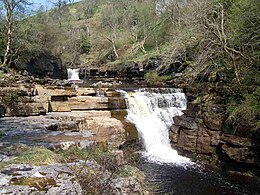
grow profusely in the area. The falls can be easily visited by a riverside path from Keld. However, care should be taken since the stones around the falls are often wet and slippery. Visitor numbers to the falls are swollen by walkers along the
275:
221:
459:
268:
66:
420:
113:
311:
261:
150:
371:
301:
86:
386:
61:
232:
112:
The falls drop 10 metres (33 ft) over two cascades and are surrounded by Kisdon Force Woods, a
401:
464:
98:
195:
170:
366:
133:
29:
376:
321:
82:
74:
57:
53:
341:
94:
73:
Kisdon Force is one of several waterfalls on the Swale in the Keld area: the others are
361:
356:
296:
453:
351:
336:
306:
78:
331:
326:
316:
121:
406:
138:
45:
435:
422:
49:
41:
253:
21:
125:
117:
116:
covering an area of 38 hectares, which consists of mixed broad-leaved
90:
129:
28:
20:
257:
97:. The falls in this area are termed "forces" after the
171:"Guide to the River Swale (Hoggarths Bridge to Muker)"
85:. All occur where the river cuts a gorge through the
394:
289:
141:, a long-distance footpath that passes the falls.
60:, 500 metres downstream from the small hamlet of
33:Kisdon Force in August 2006 after a night of rain
196:"Kisdon Force, Keld, Swaledale, Yorkshire Dales"
269:
52:, England. The falls are situated within the
8:
276:
262:
254:
162:
222:"SSSI Information: Kisdon Force Woods"
16:Waterfall in North Yorkshire, England
7:
114:Site of Special Scientific Interest
14:
231:. Natural England. Archived from
200:Waterfalls of the Yorkshire Dales
385:
1:
460:Waterfalls of North Yorkshire
151:List of waterfalls of England
54:Yorkshire Dales National Park
132:dominating. In the spring,
481:
383:
202:. James Paul Photography
284:Waterfalls of Yorkshire
175:The UK Rivers Guidebook
87:Carboniferous Limestone
34:
26:
89:between the hills of
32:
24:
432: /
436:54.4041°N 2.1575°W
64:at grid reference
35:
27:
415:
414:
56:in the county of
472:
447:
446:
444:
443:
442:
441:54.4041; -2.1575
437:
433:
430:
429:
428:
425:
389:
278:
271:
264:
255:
248:
247:
245:
243:
237:
226:
218:
212:
211:
209:
207:
192:
186:
185:
183:
181:
167:
69:
480:
479:
475:
474:
473:
471:
470:
469:
450:
449:
440:
438:
434:
431:
426:
423:
421:
419:
418:
416:
411:
390:
381:
290:North Yorkshire
285:
282:
252:
251:
241:
239:
235:
229:Natural England
224:
220:
219:
215:
205:
203:
194:
193:
189:
179:
177:
169:
168:
164:
159:
147:
83:Wain Wath Force
75:East Gill Force
65:
58:North Yorkshire
40:is a series of
17:
12:
11:
5:
478:
476:
468:
467:
462:
452:
451:
413:
412:
410:
409:
404:
398:
396:
395:West Yorkshire
392:
391:
384:
382:
380:
379:
374:
369:
364:
362:Scaleber Force
359:
354:
349:
344:
339:
334:
329:
324:
319:
314:
312:Cauldron Falls
309:
304:
302:Beezeley Falls
299:
293:
291:
287:
286:
283:
281:
280:
273:
266:
258:
250:
249:
238:on 4 June 2011
213:
187:
161:
160:
158:
155:
154:
153:
146:
143:
15:
13:
10:
9:
6:
4:
3:
2:
477:
466:
463:
461:
458:
457:
455:
448:
445:
408:
405:
403:
400:
399:
397:
393:
388:
378:
375:
373:
370:
368:
365:
363:
360:
358:
355:
353:
352:Mallyan Spout
350:
348:
345:
343:
340:
338:
335:
333:
330:
328:
325:
323:
320:
318:
315:
313:
310:
308:
305:
303:
300:
298:
295:
294:
292:
288:
279:
274:
272:
267:
265:
260:
259:
256:
234:
230:
223:
217:
214:
201:
197:
191:
188:
176:
172:
166:
163:
156:
152:
149:
148:
144:
142:
140:
135:
131:
127:
123:
119:
115:
110:
108:
104:
100:
96:
92:
88:
84:
80:
79:Catrake Force
76:
71:
68:
63:
59:
55:
51:
47:
43:
39:
31:
23:
19:
417:
346:
342:Janet's Foss
332:Gordale Scar
327:Falling Foss
240:. Retrieved
233:the original
228:
216:
204:. Retrieved
199:
190:
178:. Retrieved
174:
165:
111:
106:
102:
95:Rogan's Seat
72:
38:Kisdon Force
37:
36:
25:Kisdon Force
18:
439: /
139:Pennine Way
46:River Swale
454:Categories
424:54°24′15″N
407:Goit Stock
367:Stainforth
157:References
42:waterfalls
465:Swaledale
427:2°09′27″W
377:Wain Wath
322:East Gill
242:20 August
206:20 August
180:20 August
134:primroses
50:Swaledale
372:Thornton
357:Richmond
297:Aysgarth
145:See also
126:wych elm
118:woodland
67:NY898010
337:Hardraw
307:Catrake
44:on the
402:Brontë
347:Kisdon
317:Cotter
91:Kisdon
236:(PDF)
225:(PDF)
130:rowan
120:with
101:word
99:Norse
244:2009
208:2009
182:2009
128:and
107:foss
103:fors
93:and
81:and
62:Keld
122:ash
105:or
70:.
48:in
456::
227:.
198:.
173:.
124:,
77:,
277:e
270:t
263:v
246:.
210:.
184:.
Text is available under the Creative Commons Attribution-ShareAlike License. Additional terms may apply.