37:
404:
244:. It was situated on the north side of the B6351 approximately 1/4 mile from the village centre. The station closed to passengers on 22 September 1930 and to goods traffic on 30 March 1953, which was earlier than the northern part of the branch (in 1965). The station consisted of one passenger platform, as well as a
73:
445:
111:
479:
474:
248:
for local freight. The bridge crossing the
College Burn, a short way west of the station was damaged in floods in 1948, along with a bridge that was washed away near Mindrum.
469:
464:
499:
438:
489:
431:
484:
241:
148:
36:
494:
158:
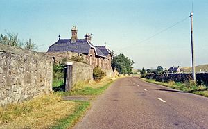
274:(track since removed) can be clearly seen to the west and east of the station. Much of this is now used for farming purposes.
403:
105:
316:
225:
55:
363:
271:
383:
263:
The original signal box also remains, now converted into a storage shed. There is also a prefabricated
245:
411:
415:
375:
229:
257:
59:
458:
291:
264:
88:
75:
419:
267:
and shed in the grounds of the
Station Master's house.
260:'s house are still in existence as private dwellings.
16:
Disused railway station in
Kirknewton, Northumberland
192:
184:
169:
164:
154:
144:
139:
131:
126:
118:
104:
67:
51:
46:
23:
480:Railway stations in Great Britain closed in 1930
475:Railway stations in Great Britain opened in 1887
256:Both the station building itself and the former
240:The station opened on 5 September 1887 by the
439:
8:
470:Former North Eastern Railway (UK) stations
465:Disused railway stations in Northumberland
446:
432:
35:
20:
500:North East England railway station stubs
342:
283:
410:This article on a railway station in
7:
400:
398:
228:, England from 1887 to 1953 on the
418:. You can help Knowledge (XXG) by
14:
490:1953 disestablishments in England
402:
321:www.northumberlandgazette.co.uk
41:The site of the station in 1991
485:1887 establishments in England
292:"Disused Stations: Kirknewton"
1:
317:"Glendale, History Society"
516:
495:Kirknewton, Northumberland
397:
226:Kirknewton, Northumberland
222:Kirknewton railway station
170:5 September 1887
382:
374:
362:
215:
211:
207:
34:
388:Line and station closed
368:Line and station closed
193:30 March 1953
224:served the village of
242:North Eastern Railway
149:North Eastern Railway
188:Closed to passengers
85: /
47:General information
412:North East England
358:Following station
346:Preceding station
270:The course of the
89:55.5674°N 2.1442°W
427:
426:
393:
392:
389:
369:
352:Disused railways
219:
218:
203:Closed completely
185:22 September 1930
127:Other information
507:
448:
441:
434:
406:
399:
387:
367:
343:
332:
331:
329:
327:
313:
307:
306:
304:
302:
296:Disused Stations
288:
246:marshalling yard
200:
198:
177:
175:
145:Original company
114:
100:
99:
97:
96:
95:
94:55.5674; -2.1442
90:
86:
83:
82:
81:
78:
39:
21:
515:
514:
510:
509:
508:
506:
505:
504:
455:
454:
453:
452:
395:
386:
376:Cornhill Branch
366:
341:
336:
335:
325:
323:
315:
314:
310:
300:
298:
290:
289:
285:
280:
254:
238:
230:Cornhill Branch
196:
194:
173:
171:
110:
93:
91:
87:
84:
79:
76:
74:
72:
71:
62:
42:
30:
29:
28:
17:
12:
11:
5:
513:
511:
503:
502:
497:
492:
487:
482:
477:
472:
467:
457:
456:
451:
450:
443:
436:
428:
425:
424:
407:
391:
390:
381:
378:
373:
370:
360:
359:
356:
353:
350:
347:
340:
339:External links
337:
334:
333:
308:
282:
281:
279:
276:
258:Station Master
253:
250:
237:
234:
217:
216:
213:
212:
209:
208:
205:
204:
201:
190:
189:
186:
182:
181:
178:
167:
166:
162:
161:
156:
152:
151:
146:
142:
141:
137:
136:
133:
129:
128:
124:
123:
120:
116:
115:
108:
106:Grid reference
102:
101:
69:
65:
64:
60:Northumberland
53:
49:
48:
44:
43:
40:
32:
31:
26:
25:
24:
15:
13:
10:
9:
6:
4:
3:
2:
512:
501:
498:
496:
493:
491:
488:
486:
483:
481:
478:
476:
473:
471:
468:
466:
463:
462:
460:
449:
444:
442:
437:
435:
430:
429:
423:
421:
417:
413:
408:
405:
401:
396:
385:
379:
377:
371:
365:
361:
357:
354:
351:
348:
345:
344:
338:
322:
318:
312:
309:
297:
293:
287:
284:
277:
275:
273:
272:permanent way
268:
266:
261:
259:
251:
249:
247:
243:
235:
233:
231:
227:
223:
214:
210:
206:
202:
191:
187:
183:
179:
168:
163:
160:
157:
155:Post-grouping
153:
150:
147:
143:
138:
134:
130:
125:
121:
117:
113:
109:
107:
103:
98:
70:
66:
61:
57:
54:
50:
45:
38:
33:
22:
19:
420:expanding it
409:
394:
324:. Retrieved
320:
311:
299:. Retrieved
295:
286:
269:
262:
255:
239:
221:
220:
18:
92: /
68:Coordinates
459:Categories
278:References
265:Nissen Hut
197:1953-03-30
174:1887-09-05
77:55°34′03″N
56:Kirknewton
27:Kirknewton
165:Key dates
119:Platforms
80:2°08′39″W
112:NT910304
52:Location
380:
372:
364:Mindrum
355:
349:
301:2 March
236:History
195: (
172: (
140:History
135:Disused
63:England
326:6 June
180:Opened
132:Status
414:is a
384:Akeld
252:Today
416:stub
328:2019
303:2018
159:LNER
461::
319:.
294:.
232:.
58:,
447:e
440:t
433:v
422:.
330:.
305:.
199:)
176:)
122:1
Text is available under the Creative Commons Attribution-ShareAlike License. Additional terms may apply.