77:
60:
400:
110:
392:
117:
84:
462:
connection between
Knarvik and Bergen (Knarvik – Steinestø), which historically transported cars and people between the two places was in use up until the completion of the Nordhordland Bridge. That ferry connection was at one time carrying more vehicles than any other car ferry connection in
415:
highway runs straight through the village dividing it into two major parts. The northern part is where the large shopping mall is located while the southern part is still in its original state with scattered buildings and shops.
443:
In recent years population and traffic have increased creating demand for an upgrade of the infrastructure. Rush hour traffic is an increasingly common sight.
76:
59:
145:
223:
575:
570:
420:
307:
109:
362:
187:
427:
was completed in 2014 to serve the growing community. Before its completion, residents had to travel up to
384:
of 1,688 inhabitants per square kilometre (4,370/sq mi). This makes it the largest settlement in the
535:
334:
286:
296:
408:
455:
447:
399:
211:
412:
381:
338:
228:
199:
507:
489:
493:
451:
428:
349:. The village is located on the mainland, about 20 km (12 mi) straight north of
424:
192:
564:
419:
Knarvik has several kindergartens, a junior high school, and a regional high school (
366:
350:
32:
380:
The 3.48-square-kilometre (860-acre) village has a population (2019) of 5,875 and a
385:
358:
216:
374:
370:
303:
282:
160:
147:
432:
277:
28:
391:
342:
204:
17:
464:
346:
180:
511:
459:
411:, the largest shopping centre in Nordhordland with 61 stores. The
398:
390:
354:
494:"Urban settlements. Population and area, by municipality"
539:
435:, located about 4 km (2.5 mi) to the north.
314:
293:
276:
268:
260:
255:
247:
239:
234:
222:
210:
198:
186:
176:
43:
423:) with more than 1,000 students. The newly built
407:The centre of the village is the site of the
8:
40:
476:
313:
275:
254:
246:
233:
175:
140:
68:
56:
530:
528:
484:
482:
480:
292:
267:
259:
238:
221:
209:
197:
185:
7:
373:(heading northwest). The village of
377:lies immediately north of Knarvik.
243:3.48 km (1.34 sq mi)
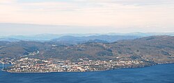
64:View of the village (looking north)
25:
446:Today, Knarvik is connected with
38:Village in Western Norway, Norway
115:
108:
82:
75:
58:
116:
83:
1:
369:(heading southwest), and the
272:1,688/km (4,370/sq mi)
592:
421:Knarvik vidaregåande skule
403:Knarvik videregåande skule
395:Amfi Knarvik shopping mall
353:at the confluence of four
26:
141:
69:
57:
50:
454:(finished 1982) and the
27:Not to be confused with
388:district of Vestland.
251:38 m (125 ft)
96:Location of the village
490:Statistisk sentralbyrå
404:
396:
536:Store norske leksikon
458:(finished 1994). The
450:to the south via the
402:
394:
365:(heading southeast),
335:administrative centre
295: • Summer (
576:Alver (municipality)
571:Villages in Vestland
269: • Density
161:60.54528°N 5.28194°E
99:Show map of Vestland
456:Nordhordland Bridge
448:Bergen Municipality
157: /
492:(1 January 2019).
431:in the village of
413:European route E39
405:
397:
382:population density
339:Alver Municipality
261: • Total
240: • Total
229:Alver Municipality
132:Show map of Norway
324:
323:
166:60.54528; 5.28194
16:(Redirected from
583:
552:
551:
549:
547:
532:
523:
522:
520:
518:
510:(in Norwegian).
504:
498:
497:
486:
452:Hagelsund Bridge
429:Alversund Church
361:(heading east),
300:
172:
171:
169:
168:
167:
162:
158:
155:
154:
153:
150:
133:
129:Knarvik (Norway)
119:
118:
112:
100:
86:
85:
79:
62:
41:
21:
591:
590:
586:
585:
584:
582:
581:
580:
561:
560:
558:
556:
555:
545:
543:
534:
533:
526:
516:
514:
506:
505:
501:
488:
487:
478:
473:
441:
320:
294:
165:
163:
159:
156:
151:
148:
146:
144:
143:
137:
136:
135:
134:
131:
130:
127:
126:
125:
124:
120:
103:
102:
101:
98:
97:
94:
93:
92:
91:
87:
65:
53:
46:
39:
36:
23:
22:
15:
12:
11:
5:
589:
587:
579:
578:
573:
563:
562:
554:
553:
542:(in Norwegian)
524:
499:
475:
474:
472:
469:
440:
439:Transportation
437:
425:Knarvik Church
409:Knarvik Senter
322:
321:
318:
316:
312:
311:
301:
291:
290:
280:
274:
273:
270:
266:
265:
262:
258:
257:
253:
252:
249:
245:
244:
241:
237:
236:
232:
231:
226:
220:
219:
214:
208:
207:
202:
196:
195:
193:Western Norway
190:
184:
183:
178:
174:
173:
139:
138:
128:
122:
121:
114:
113:
107:
106:
105:
104:
95:
89:
88:
81:
80:
74:
73:
72:
71:
70:
67:
66:
63:
55:
54:
51:
48:
47:
44:
37:
24:
14:
13:
10:
9:
6:
4:
3:
2:
588:
577:
574:
572:
569:
568:
566:
559:
541:
537:
531:
529:
525:
513:
509:
503:
500:
495:
491:
485:
483:
481:
477:
470:
468:
466:
461:
457:
453:
449:
444:
438:
436:
434:
430:
426:
422:
417:
414:
410:
401:
393:
389:
387:
383:
378:
376:
372:
368:
367:Salhusfjorden
364:
360:
356:
352:
348:
344:
340:
336:
332:
328:
319:5914 Isdalstø
317:
309:
305:
302:
298:
288:
284:
281:
279:
271:
263:
250:
242:
230:
227:
225:
218:
215:
213:
206:
203:
201:
194:
191:
189:
182:
179:
170:
142:Coordinates:
111:
78:
61:
49:
42:
34:
33:Narvik (town)
30:
19:
557:
544:. Retrieved
515:. Retrieved
502:
445:
442:
418:
406:
386:Nordhordland
379:
359:Osterfjorden
330:
326:
325:
224:Municipality
217:Nordhordland
164: /
565:Categories
471:References
371:Radfjorden
363:Sørfjorden
256:Population
152:05°16′55″E
149:60°32′43″N
540:"Knarvik"
508:"Knarvik"
460:car ferry
433:Alversund
333:) is the
331:Knarrviki
315:Post Code
304:UTC+02:00
283:UTC+01:00
278:Time zone
248:Elevation
29:Knarrevik
18:Knarrviki
546:24 March
517:24 March
375:Isdalstø
345:county,
343:Vestland
212:District
205:Vestland
327:Knarvik
177:Country
123:Knarvik
90:Knarvik
52:Village
45:Knarvik
465:Norway
355:fjords
351:Bergen
347:Norway
200:County
188:Region
181:Norway
512:yr.no
264:5,875
548:2014
519:2014
329:(or
308:CEST
235:Area
357::
341:in
337:of
297:DST
287:CET
31:or
567::
538:.
527:^
479:^
467:.
550:.
521:.
496:.
310:)
306:(
299:)
289:)
285:(
35:.
20:)
Text is available under the Creative Commons Attribution-ShareAlike License. Additional terms may apply.