1887:
was under construction, Shigekata fought with his younger brother, Noriyuki. Shigekata injured one of the key warlords, Yoshihiro, and made the
Shimadzu troops retreat. In 1568, Shigekata who was as the representative of Ito and Hongo who was from Shimadzu sat down in post-war negotiations in Obi. Shigekata achieved pledging two things, Shimadzu troops retreating and ceding of Obi territory. Since then Shigekata was known as a man with great intelligence and bravery. In 1572, at the Kizakibaru-no-Tatakai, or the Battle of Kizakibaru, Shigekata fought with Ito where he died. Shegekata's head was sent to Ichirinji Temple, which was his family temple. There is a five-story pagoda which is engraved the word, which says "Ryushitsukuko". They say that this pagoda is the one for Mera Shigekata, who was also known as Chikugo-no-Kami.
1709:. On his way back to Kyoto, he stopped by Hinamori, nearby Kobayashi city. At that time, the hills surrounding the Mt. Idenoyama were said to have housed the royal family, and there was a beautiful lady called Izumihime. Izumihime poured tea made with the spring water from Idenoyama to the Emperor. The cup of tea made him comforted and healed the tiredness of the battle. The emperor and Izumihime grew warm affection one day. The time of return came and the Emperor departed for Kyoto. It is said that she mourned herself in the pond and turned into a snake as a guardian angel. Even now, the Benzaiten Festival is held every April to celebrate Mizugami-sama, and there is still a stone that is connected to the grave of Izumihime next to the cemetery in Oidemizu district. Excerpt of the legendary "Izumihime Monogatari"
1902:
down and wait ( meaning buse) to the two different sides in advance, then the left squad attacks ( meaning tsuri) pretending to be defeated. The best spearman, Masaie boldly turned back, and was one on one fight against
Shimazu Hyogo-no-Kami (Yoshihiro). At the moment when Masaie made a deadly blow to Yoshihiro, the spear missed the target because Yoshihiro's horse broke its front knee. During that time Masaie was surrounded and killed by Shimadzu. They say that the place where this one on one battle took place is today's Kayumochida area. The tomb of Yunokizaki Tango-no-Kami remains in the northwest, and a stone monument was built in honor of the martial arts, and is still carefully protected. The tomb is located slightly off Kayumochida the Old Battlefield Ruins, which is designated by Kobayashi city.
1753:(female) descended from Takama-no-Hara, heaven, to Takachiho-no-Mine. There is a halberd placed upside down on the peak of Takachiho-no-Mine, this is called Ama-no-Sakahoko, or the halberd of the heaven. It is said, that Izanagi-no-Mikoto and Izanami-no-Mikoto placed the Ama-no-Sakahoko on the peak of Takachiho-no-Mine, and mixed the earth to create the country. The origin of "Kirishima" is based on the theory that, if you look into this area from afar, Kirishima Mountain range looks like an island floating in the sea of fog. Or, it is said that when the Tenson-Korin, the fog was very thick and they could hardly see surroundings. As soon as they sowed the rice ears brought from Takama-no-Hara, the fog soon cleared. Or, there is also a theory that the volcanic plume was regarded as fog.
1822:(now Ishigori river) surrounds the west, north and east of this Kobayashi castle, forming like a natural moat, and the southern part faces cliffs of shirasu soil, which is volcanic ash soil making it difficult to climb. The Kobayashi castle was protected by the natural hazards that cannot be easily reached to the castle. At first it was called Mitsuyama Castle or Minoyama Castle, however there was another castle called the same for Kitahara, so Ito's castle was renamed Kobayashi Castle since it was in Kobayashi Village. At present, it is a privately owned land. There are markers, such as the indicator of the Honmaru, the main bailey, but most of part is covered with grove of mixed trees.
114:
1720:
erosion by rivers. There is a 17.5-meter-high phallic-shaped yang stone (male stone), and beside it is a 5.5-meter-periphery-shaped gylinite (female stone). Since ancient times, it has been worshiped as the god of marriage, child treasure and prayer for safe delivery. However, it became widely known as a sightseeing spot after a new road was constructed in 1917 (until then, there was no other way to the ridge). In 1950, Kobayashi
Municipal "Hamanoseso Ryokan" was opened, and since then, the "Inyoseki Festival" is held every September. In April 1929, Noguchi Ujo, a poet, visited this Inyoseki and composed a poem, which is on a monument erected in 1951.
442:, including Mt. Karakuni (1,700 meters), Mt. Shinmoedake (1421 meters), Mt. Imori (1,344 meters), Mt. Nakadake (1,332 meters), Mt. Yadake (1,132 meters), and Mt. Takachiho (1,132 meters). Ohataike, a crater lake, is included in the city limits. The Ikoma Plateau (elevation 540 meters) is located at the northern foot of the Kirishima Mountain Range. In the central and southern part of the city, the Kobayashi Basin is formed by the collapse of a caldera, and the northern part of the Kobayashi Basin contains the central urban area of the city, and because of the volcanic nature of the geography, there are many
98:
534:) with hot, humid summers and cool winters. The average annual temperature in Kobayashi is 16.3 °C (61.3 °F). The average annual rainfall is 2,774.1 mm (109.22 in) with June as the wettest month. The temperatures are highest on average in August, at around 26.4 °C (79.5 °F), and lowest in January, at around 5.8 °C (42.4 °F). The highest temperature ever recorded in Kobayashi was 38.3 °C (100.9 °F) on 18 August 2020; the coldest temperature ever recorded was −8.7 °C (16.3 °F) on 25 January 2016.
51:
2184:
76:
1619:
1609:
1599:
66:
1731:
of
Takachiho-no-Mine (1,574m above sea level). It is an active volcano that repeats eruptions since its history was recorded (volcanic activation is ranked B by the Japan Meteorological Agency), and active volcanic activity has continued particularly at Shinmoe-dake and Ohachi. Those mountains have been selected as volcanoes that need to be monitored and an observation system for volcanic disaster prevention by the Volcanic Eruption Prediction Council has been established.
370:
1800:
unexpected resistance. When
Shimazu Yoshihiro, who had been waiting for the Ito army at Iino Castle, received the report, he immediately sent his troops to Kizakibaru, and on May 4, the troops went into a fierce battle. The battle ended with a major victory for Shimadzu, and the defeated Ito quickly declined, and Shimadzu began to rule over Himuka-no-Kuni. This is The Battle of Kizakibaru, which was later called "The Battle of Okehazama" in Kyushu.
1589:
1558:
1876:
the next year, but in 1602, he was killed by
Shimadzu Tadatsune on the way to Kyoto. According to Professor Yamamoto from Historiographical Institute at the University of Tokyo, for Shimadzu, there was no choice to kill his vassals, Ijuin Tadasane, who was a key person of opposition. Here in his tomb, there is a memorial tower, which was built for Ijuin Tadasane.
1804:
warlord Godai
Tomoyasu/Shozaemon built a five-story pagoda to comfort the spirits of Ito troops, and in 1817, the lord of Kobayashi built a monument and engraved the sentence "Look at the old days of today". The mound is a historic site designated by Miyazaki prefecture. Location; 160-2 Magata, Kobayashi, Miyazaki (located on a hill behind Kobayashi High School)
2117:
121:
1472:, the area was incorporated into Kagoshima Prefecture, but was later transferred to Miyazaki Prefecture. The village of Kobayashi was established on May 1, 1889, with the creation of the modern municipalities system. It was raised to town status on December 25, 1912, and to city status on April 1, 1950.
1799:
Ito
Yoshisuke was a daimyo who ruled most of the Himuka-no-Kuni. On May 3, 1572, he with around 3,000 troops attacked Kakuto Castle, protected by Shimadzu's vassal, Kawakami Tadatomo, from Minoyama (Kobayashi), the front base. However, the Ito army retreats to Kizakibaru (Iino, Ebino-city) once after
1684:
One of the spring waters of the
Kirishima Mountains, abundant water flow of 1 ton per second flows into the largest reservoir in Kobayashi, Idenoyama Pond. Idenoyama Pond was created by the Satsuma Domain in 1614 for irrigation water, and around this area a large number of flora and fauna inhabit. In
1901:
In 1572, he joined the
Kizakibaru-no-Tatakai, or the Battle of Kizakibaru. However, his general Ito was routed because of the trap called "Tsuri-no-Buse" by their enemy, Shimadzu. Tsuri-no-Buse were tactics in a field battle. The entire army is divided into three squads, two of which are hide or lay
1886:
Mera Shigekata was a warlord, serving Ito, the Daimyo of Himuka-no-Kuni, and Shigekata also was the lord of Suki Castle. Mera Shigekata was ordered to build Kobayashi castle by Ito, this castle was by the border of neighboring state, Satsuma. In 1566, Shimadzu troops attacked Kobayashi castle, which
1860:
They say that the place where this one on one battle took place is today's Kayumochida area. The tomb of Yunokizaki Tango-no-Kami remains in the northwest, and a stone monument was built in honor of the martial arts, and is still carefully protected. Kayumochida the Old Battlefield Ruins is where is
1875:
However, in 1599, Ijuin Tadamune, the father was killed by Shimadzu Tadatsune because the father was too proud of his power. The son, Ijuin Tadasane was standing in his castle, Tsuno Castle, and decided to break ranks with Shimadzu. This is called Shonai-no-Ran, the Shonai Rebellion. He surrendered
1871:
Ijuin Tadasane was a warlord, serving Shimadzu like his father, Ijuin Tadamune. In 1597, Toyotomi Hideyoshi commanded the invasion to Korea. Father and son, Ijuin Tadasane, went to war as the Shimadzu troops. In 1598 in the Shisen-no-Tatakai, the Battle at Shisen, it is said that 7,000 of Shimadzu
1833:
Suki Castle is a collective term. It has Hidaki castle at the foot, Araki castle on the middle, then Matsuo / Tsurumaru castle at the summit as a Honmaru, the main bailey. Matsuo Castle is surrounded by cliffs and only a part of the southwest is a steep slope. At present there are markers that mark
1730:
Kirishimayama Mountain is a collective term for volcanic groups near the border between Miyazaki and Kagoshima prefectures in southern Kyushu. Also called Kirishima Volcanoes, they form a mountain mass between and around the highest peak of Karakuni-dake (1,700m above sea level) and the sacred peak
1675:
Idenoyama Park is located in south west from center of Kobayashi city. This park has a pond where the water source is from Idenoyama mountain, and its spring water is selected as Japan's 100 remarkable waters. This is the home place of the Firefly Festival every May. Features a freshwater aquarium,
1856:
In 1572, the troops of Ito were chased by their enemy Shimadzu at the Kizakibaru-no-Tatakai, or the battle of Kizakibaru. The best spearman, Yunokizaki Tango-no-Kami (Masaie) boldly turned back, and had a one on one fight against Shimazu Hyogo-no-Kami (Yoshihiro). At the moment when Masaie made a
1803:
Of the more than 500 Ito troops who died in the battle of Kizakibaru, more than 200 main ones, such as General Ito Kagamori/Sukeyasu, were buried in Magata-Inba-Zuka, and this tomb was later called Ito-zuka. They are just memorial towers, there are no bodies under them. The descendants of Shimazu
1917:
Crossing the bridge leads to a view of this waterfall cluster. The falls are named after a legend which tells of a cruel stepmother who took her six-year-old stepdaughter to the falls to murder her. However, the child had tied their sashes together without the stepmother realizing, and when the
1719:
Inyoseki is a couple rock in the Homanose river which is located in east part of Kobayashi city. You can find them in the downstream of Sannomiyakyo Gorge. The volcanic activity that was activated about 1.8 million years ago, deposited a large amount of volcanic ash and lava, which was formed by
1845:
The Castle is surrounded by the Jonoshita river and a cliff, which forms a natural barrier. Initially, it was thought that the castle had Honmaru, the main bailey, in the west and Ninomaru, the second bailey, in the east, but later investigation revealed those were opposite. The Nojiri Honjo,
1846:
Honmaru, was at the east and the Nojiri Shinjo, Ninomaru, which was later built in the west. So, this castle was actually a paired castle. Currently it is a farmland, but only the remains on the Nojiri Shinjo side. This well is a Cultural Property designated by Nojiri Town.
437:
to the southwestern. Kobayashi is the largest municipality in the Nishimoro region, and as it is located almost in the center of the Nishimoro region, it plays a central role in industry and economy. The southwestern part of the city lies in the northeastern part of the
1787:
Kagura at midnight. When Kirishima Jingu was relocated to its current location, many people are said to have heard Kagura, sounds that should not be heard at midnight. Originally, Kagura involved songs and dances that were dedicated to the
1685:
late May to early June, it is a great habitat of Genji fireflies. There is a promenade so you can walk by the pond and enjoy the fireflies dancing. At the adjacent Miyazaki Prefectural Fisheries Experimental Station Kobayashi Branch,
1542:
Kobayashi has 14 public elementary schools and ten public junior high schools operated by the city, and two public high schools operated by the Miyazaki Prefectural Board of Education. There is also one private high school.
1780:
Mitarashigawa, or Mitarashi river. A river that dries out in winter and a lot of water comes out around May. It is said, that it contains the water of Manai brought from Takama-no-Hara when Tenson-Korin, or when the gods
1765:
Makazu-no-Tane, or seeds without sowing rice may grow on the mountains. This is attributed to the species brought from Takama-no-Hara, or heaven, when the Tenson-Korin; two gods descendant to Kirishima mountain in ancient
1769:
Moji Iwa, or character rock on the west side of Kirishima Shrine, there is a large rock of 10 cubic meters. You will find some Sanskrit characters are engraved on the inside despite the small gaps that are difficult to
1897:
Yunokizaki Masaie was a warlord, serving Ito, the Daimyo of Himuka-no-Kuni, and Mas the load of Yunokizaki Castle. Masaie was a master of spears and was declared as "the best spear-man in Nisshu (Himuka-no-Kuni)."
1956:
Winter Festival: Late November/Early December. Features annual Christmas Lights Display at Kobayashi Station. The lights were designed by students of the local technical school, now Kobayashi Shuho High School.
1773:
Kame Ishi, or turtle rock on the old approach to Kirishima Shrine, there is a rock that looks exactly like a turtle. It is said, that a turtle that has broken his promise to God and was then turned into a
1817:
In 1566, Ito Yoshisuke commanded Mera Shigekata, the lord of Suki castle, to build a castle to defend against the Shimazu, the daimyo of Satsuma and as a front-line base for the Iino Castle attack. The
1510:
city council of 19 members. Kobayashi, together with the town of Takaharu, contributes two members to the Miyazaki Prefectural Assembly. In terms of national politics, the city is part of the
1701:
The inhabitants, who lived in the mountains of Kuma-gun in Higo, Kurino, Yokokawa, Hyokiyama, and Soo-gun in Osumi, defeated the court and did not donate their annual tribute to the court.
1705:
visited the Kyushu region to subdue them. He departed from Kyoto, passed through Nagato and Toyokuni, then at Hyuga, he established Takaya-no-miya (near Saito) to fight the
1784:
Ryodogawa, or Ryodo river. A river that flows only from June to September. The river flows twice at intervals of several days and is called the Ryodo, meaning twice river.
113:
2016:
1857:
deadly blow to Yoshihiro, the spear missed the target because Yoshihiro's horse broke its front knee. During that time Masaie was surrounded and killed by Shimadzu.
2046:
1830:
Suki Castle was one of the Forty-eight Castles of Ito on a hill in the plains. It is also known as Tsurumaru Castle. Currently, Shiroyama Park nearby Sukimuland.
97:
2183:
1693:
has been commercialized in cooperation with the private sector. There is a restaurant where you can taste river fish such as carp trout, and sturgeon.
145:
2438:
2419:
50:
1814:
Kobayashi Castle was a castle on a hill in the plains. It is also known as Mitsuyama Castle or Minoyama Castle. Currently, Shiroyama Park.
425:
Kobayashi is located in the southwestern part of Miyazaki Prefecture, about 60 kilometers west-northwest of the prefectural capital at
2286:
2173:
1842:
Nojiri Castle is one of the Forty-eight Castles of Ito on a hill in the plains. It is located in Kobayashi city, former Nojiri Town.
1515:
1123:
Per Japanese census data, the population of Kobayashi in 2020 is 43,670 people. Kobayashi has been conducting censuses since 1920.
75:
2087:
2379:
1645:
At an elevation of 540 m (1,770 ft), the plateau offers a view of the city from its magnificent flower garden with the
1491:
1480:
528:
281:
2330:
2303:
1530:
The economy of Kobayashi is based on agriculture and forestry, as well as seasonal tourism. Kobayashi is famous for producing
1637:
A fertility shrine a which people pray to conceive children. The site has a natural rock formation that resembles a phallus.
2151:
2121:
2391:
1460:
which developed around this castle became the core of modern Kobayashi. The Shimazu continued to rule the area as part of
2443:
1575:
65:
2052:
2022:
1469:
1109:
1932:
Sakura Festival: Late March-Early April. Features flower viewing and local events in locations all over Kobayashi.
1777:
Kazaana, or wind hole. There is a rock with a hole where the wind blows out on the old approach to Kirishima Shrine.
323:
2201:
524:
286:
1622:
1612:
1602:
1592:
185:
1646:
2342:
1872:
troops defeated 37,000 Korean troops. Since then the name of Shimadzu was feared through Korea, even China.
1571:
473:
2166:
1561:
1511:
2347:
2211:
1657:
Home of the Firefly Festival every May. Features a freshwater aquarium, restaurants specializing in
512:
506:
434:
197:
1909:
Featuring a cliff which is 32 m (105 ft) high and stretching 60 m (200 ft) wide.
2406:
2357:
2318:
2187:
489:
468:
430:
402:
265:
202:
1426:
as it was the location of a military settlement on the frontier of the Yamato Kingdom against the
2401:
2384:
2367:
2362:
2308:
2296:
2260:
1972:
1966:
483:
478:
414:
2240:
369:
2352:
2250:
2159:
1419:
1062:
500:
417:
of 75 persons per km. The total area of the city is 562.95 km (217.36 sq mi).
2396:
2335:
2323:
2313:
1487:
1451:
495:
1761:
People say that a hermit lives in the Kirishima. Below are The Seven Wonders of Kirishima:
2372:
2270:
2235:
2219:
2196:
458:
439:
426:
398:
41:
2091:
1476:
1461:
1439:
353:
333:
2141:
2432:
2291:
2255:
1702:
1519:
1503:
1427:
941:
463:
2075:
1447:
1435:
1456:
1978:
1819:
1649:
at its back. October is Cosmos season while April/May feature Icelandic poppies.
1443:
1423:
443:
357:
1999:
1565:
1507:
1465:
1431:
410:
261:
160:
147:
1676:
restaurants specializing in carp dishes, and a beautiful lakefront scenery.
1557:
256:
2116:
1686:
2265:
1750:
1746:
446:. The Iwase River flows from east to west through the Kobayashi Basin.
343:
541:
Climate data for Kobayashi (2000−2020 normals, extremes 2000−present)
1741:
1706:
1690:
1442:, after considerable turmoil, the area came under the control of the
190:
298:
2129:
1430:
further south. Miyama Castle was completed around the time of the
406:
368:
1745:, this mountain was the place of Tenson-korin; a couple of gods,
1918:
stepmother pushed the girl over, they both fell to their deaths.
1658:
1531:
1286:
1144:
2155:
1483:) was merged into Kobayashi, roughly doubling the city's size.
1454:
in 1572, who established a stronghold at Kobayashi Castle. The
1281:
1139:
1689:
has been successfully hatched using spring water, and its
1935:
Firefly Festival at Idenoyama Park: Late May-Late June
409:. As of 1 May 2023, the city had an estimated
1506:
form of government with a directly elected mayor and a
1666:
Idenoyama Spring Water (Japan's 100 remarkable waters)
2279:
2228:
2210:
349:
339:
329:
319:
292:
280:
272:
255:
247:
239:
234:
226:
221:
213:
208:
196:
184:
176:
21:
1438:, and the area came to be called "Miyama". In the
276:Hosono 300, Kobayashi-shi, Miyazaki-ken 886-8501
388:
382:
28:
2167:
8:
1126:
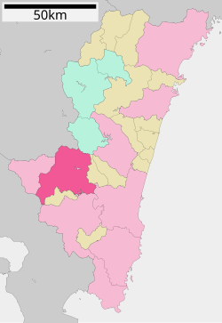
102:Location of Kobayashi in Miyazaki Prefecture
1671:Idenoyama mountain freshwater fish aquarium
2174:
2160:
2152:
2041:
2039:
1941:Suki City Fireforks Festival: Mid-August
1938:Water Festival: First Saturday of August
1556:
1418:The area of Kobayashi was part of ancient
1125:
537:
18:
2011:
2009:
2071:
2069:
1944:Suki Chestnut Festival: Late September
1661:dishes, and beautiful lakefront scenery.
1991:
1914:Suki Suspension Bridge and Mamako Falls
314:
291:
279:
271:
254:
233:
230:562.95 km (217.36 sq mi)
220:
207:
175:
140:
106:
87:
59:
47:
2420:List of mergers in Miyazaki Prefecture
1422:and was called "Hinamori" (夷守) in the
413:of 42,139 in 19144 households, and a
1852:Kayumochida the Old Battlefield Ruins
348:
338:
328:
318:
246:
238:
225:
212:
195:
183:
94:
7:
2000:"Kobayashi City official statistics"
1947:Inyoseki Festival: Late September
1950:Harvest Festival: Early November
1494:) was also merged into Kobayashi.
1475:On March 20, 2006, the village of
90:Interactive map outlining Miyazaki
14:
120:
2182:
2115:
1953:Autumn Festival: Late November
1893:Tomb of Yunokizaki Tango-no-Kami
1617:
1607:
1597:
1587:
217:Masahiro Higo (since April 2010)
119:
112:
96:
74:
64:
49:
2142:Kobayashi City official website
2130:Kobayashi City official website
2076:Kobayashi population statistics
1969:, governor of the Bank of Japan
1486:On March 23, 2010, the town of
1446:. The Itō were defeated by the
1407:Kobayashi population statistics
1861:designated by Kobayashi city.
1:
2439:Cities in Miyazaki Prefecture
1961:Notable people from Kobayashi
529:Köppen climate classification
1882:Tomb of Mera Chikugo-no-Kami
1470:abolition of the han system
1110:Japan Meteorological Agency
1014:Average precipitation days
800:Mean daily minimum °C (°F)
660:Mean daily maximum °C (°F)
389:
2460:
1867:The Tomb of Ijuin Tadasane
1680:Overview of Idenoyama Park
1130:
1107:
540:
450:Neighboring municipalities
324:White-bellied green pigeon
2417:
2194:
1834:the spots of the castle.
1406:
1157:—
1060:
1013:
939:
869:
799:
729:
659:
589:
584:
581:
578:
575:
572:
569:
566:
563:
560:
557:
554:
551:
548:
545:
525:humid subtropical climate
383:
363:
315:
310:
306:
141:
107:
95:
88:
60:
48:
39:
29:
2287:Higashimorokata District
2047:
2017:
1647:Kirishima Mountain Range
1593:Higashikyushu Expressway
440:Kirishima Mountain Range
25:
1623:National Route 268
1613:National Route 265
1603:National Route 221
55:Cosmos in Ikoma Plateau
2380:Nishimorokata District
2088:"市町村合併情報 宮崎県 <国土地理協会>"
1492:Nishimorokata District
1481:Nishimorokata District
433:to the northeast, and
374:
251:75/km (190/sq mi)
161:31.99667°N 130.97250°E
2331:Kitamorokata District
2304:Higashiusuki District
2048:観測史上1~10位の値(年間を通じての値)
2002:(in Japanese). Japan.
1512:Miyazaki 1st district
1127:Historical population
372:
16:City in Kyushu, Japan
2124:at Wikimedia Commons
1468:. In 1871, with the
590:Record high °C (°F)
507:Kagoshima Prefecture
454:Miyazaki Prefecture
435:Kagoshima Prefecture
248: • Density
2444:Kobayashi, Miyazaki
2392:Nishiusuki District
2188:Miyazaki Prefecture
2122:Kobayashi, Miyazaki
1128:
870:Record low °C (°F)
730:Daily mean °C (°F)
490:Kumamoto Prefecture
431:Kumamoto Prefecture
403:Miyazaki Prefecture
373:Kobayashi city hall
166:31.99667; 130.97250
157: /
2018:気象庁 / 平年値(年・月ごとの値)
1973:Toshifumi Kosehira
1967:Teiichiro Morinaga
1726:Kirishima Mountain
1464:to the end of the
1434:at the end of the
415:population density
375:
240: • Total
227: • Total
214: • Mayor
2426:
2425:
2205:
2120:Media related to
1739:According to the
1629:Local attractions
1411:
1410:
1402:
1401:
1271:
1270:
1115:
1114:
367:
366:
273:City hall address
133:Location in Japan
2451:
2199:
2186:
2176:
2169:
2162:
2153:
2148:
2145:
2144:
2136:
2133:
2132:
2119:
2103:
2102:
2100:
2099:
2090:. Archived from
2084:
2078:
2073:
2064:
2063:
2061:
2059:
2043:
2034:
2033:
2031:
2029:
2013:
2004:
2003:
1996:
1810:Kobayashi Castle
1621:
1620:
1611:
1610:
1601:
1600:
1591:
1590:
1560:
1502:Kobayashi has a
1452:Satsuma Province
1288:
1283:
1275:
1274:
1146:
1141:
1133:
1132:
1129:
1017:
538:
523:Kobayashi has a
396:
395:
392:
386:
385:
302:
301:
299:Official website
172:
171:
169:
168:
167:
162:
158:
155:
154:
153:
150:
123:
122:
116:
100:
78:
68:
53:
34:
33:
32:
31:
19:
2459:
2458:
2454:
2453:
2452:
2450:
2449:
2448:
2429:
2428:
2427:
2422:
2413:
2275:
2224:
2206:
2190:
2180:
2146:
2140:
2139:
2134:
2128:
2127:
2112:
2107:
2106:
2097:
2095:
2086:
2085:
2081:
2074:
2067:
2057:
2055:
2049:
2045:
2044:
2037:
2027:
2025:
2019:
2015:
2014:
2007:
1998:
1997:
1993:
1988:
1963:
1930:
1925:
1906:Sannomiya Gorge
1631:
1618:
1608:
1598:
1588:
1584:
1572:Nishi Kobayashi
1554:
1549:
1540:
1528:
1500:
1416:
1121:
1116:
1015:
1008:
1003:
998:
993:
988:
983:
978:
973:
968:
963:
958:
953:
948:
934:
929:
924:
919:
914:
909:
904:
899:
894:
889:
884:
879:
874:
864:
859:
854:
849:
844:
839:
834:
829:
824:
819:
814:
809:
804:
794:
789:
784:
779:
774:
769:
764:
759:
754:
749:
744:
739:
734:
724:
719:
714:
709:
704:
699:
694:
689:
684:
679:
674:
669:
664:
654:
649:
644:
639:
634:
629:
624:
619:
614:
609:
604:
599:
594:
521:
452:
423:
393:
380:
297:
296:
165:
163:
159:
156:
151:
148:
146:
144:
143:
137:
136:
135:
134:
131:
130:
129:
128:
124:
103:
91:
84:
83:
82:
81:
72:
71:
56:
44:
35:
27:
26:
24:
17:
12:
11:
5:
2457:
2455:
2447:
2446:
2441:
2431:
2430:
2424:
2423:
2418:
2415:
2414:
2412:
2411:
2410:
2409:
2404:
2399:
2389:
2388:
2387:
2377:
2376:
2375:
2370:
2365:
2360:
2355:
2350:
2340:
2339:
2338:
2328:
2327:
2326:
2321:
2316:
2311:
2301:
2300:
2299:
2294:
2283:
2281:
2277:
2276:
2274:
2273:
2268:
2263:
2258:
2253:
2248:
2243:
2238:
2232:
2230:
2226:
2225:
2223:
2222:
2216:
2214:
2208:
2207:
2195:
2192:
2191:
2181:
2179:
2178:
2171:
2164:
2156:
2150:
2149:
2137:
2125:
2111:
2110:External links
2108:
2105:
2104:
2079:
2065:
2035:
2005:
1990:
1989:
1987:
1984:
1983:
1982:
1976:
1970:
1962:
1959:
1929:
1926:
1924:
1921:
1920:
1919:
1915:
1911:
1910:
1907:
1895:
1894:
1891:
1884:
1883:
1880:
1869:
1868:
1865:
1854:
1853:
1850:
1840:
1839:
1828:
1827:
1812:
1811:
1808:
1797:
1796:
1793:
1790:
1789:
1785:
1782:
1778:
1775:
1771:
1767:
1728:
1727:
1724:
1717:
1716:
1713:
1663:
1662:
1655:
1654:Idenoyama Park
1651:
1650:
1643:
1639:
1638:
1635:
1630:
1627:
1626:
1625:
1615:
1605:
1595:
1583:
1580:
1579:
1578:
1553:
1550:
1548:
1547:Transportation
1545:
1539:
1536:
1527:
1524:
1499:
1496:
1462:Satsuma Domain
1440:Sengoku period
1420:Hyūga Province
1415:
1412:
1409:
1408:
1404:
1403:
1400:
1399:
1396:
1393:
1389:
1388:
1385:
1382:
1378:
1377:
1374:
1371:
1367:
1366:
1363:
1360:
1356:
1355:
1352:
1349:
1345:
1344:
1341:
1338:
1334:
1333:
1330:
1327:
1323:
1322:
1319:
1316:
1312:
1311:
1308:
1305:
1301:
1300:
1297:
1294:
1290:
1289:
1284:
1279:
1272:
1269:
1268:
1265:
1262:
1258:
1257:
1254:
1251:
1247:
1246:
1243:
1240:
1236:
1235:
1232:
1229:
1225:
1224:
1221:
1218:
1214:
1213:
1210:
1207:
1203:
1202:
1199:
1196:
1192:
1191:
1188:
1185:
1181:
1180:
1177:
1174:
1170:
1169:
1166:
1163:
1159:
1158:
1155:
1152:
1148:
1147:
1142:
1137:
1120:
1117:
1113:
1112:
1105:
1104:
1101:
1098:
1095:
1092:
1089:
1086:
1083:
1080:
1077:
1074:
1071:
1068:
1065:
1063:sunshine hours
1058:
1057:
1054:
1051:
1048:
1045:
1042:
1039:
1036:
1033:
1030:
1027:
1024:
1021:
1018:
1011:
1010:
1005:
1000:
995:
990:
985:
980:
975:
970:
965:
960:
955:
950:
945:
937:
936:
931:
926:
921:
916:
911:
906:
901:
896:
891:
886:
881:
876:
871:
867:
866:
861:
856:
851:
846:
841:
836:
831:
826:
821:
816:
811:
806:
801:
797:
796:
791:
786:
781:
776:
771:
766:
761:
756:
751:
746:
741:
736:
731:
727:
726:
721:
716:
711:
706:
701:
696:
691:
686:
681:
676:
671:
666:
661:
657:
656:
651:
646:
641:
636:
631:
626:
621:
616:
611:
606:
601:
596:
591:
587:
586:
583:
580:
577:
574:
571:
568:
565:
562:
559:
556:
553:
550:
547:
543:
542:
536:
520:
517:
516:
515:
504:
503:
498:
487:
486:
481:
476:
471:
466:
461:
451:
448:
422:
419:
365:
364:
361:
360:
354:Cherry blossom
351:
347:
346:
341:
337:
336:
331:
327:
326:
321:
317:
316:
313:
312:
308:
307:
304:
303:
294:
290:
289:
284:
278:
277:
274:
270:
269:
259:
253:
252:
249:
245:
244:
241:
237:
236:
232:
231:
228:
224:
223:
219:
218:
215:
211:
210:
206:
205:
200:
194:
193:
188:
182:
181:
178:
174:
173:
139:
138:
132:
126:
125:
118:
117:
111:
110:
109:
108:
105:
104:
101:
93:
92:
89:
86:
85:
79:
73:
69:
63:
62:
61:
58:
57:
54:
46:
45:
40:
37:
36:
22:
15:
13:
10:
9:
6:
4:
3:
2:
2456:
2445:
2442:
2440:
2437:
2436:
2434:
2421:
2416:
2408:
2405:
2403:
2400:
2398:
2395:
2394:
2393:
2390:
2386:
2383:
2382:
2381:
2378:
2374:
2371:
2369:
2366:
2364:
2361:
2359:
2356:
2354:
2351:
2349:
2346:
2345:
2344:
2343:Koyu District
2341:
2337:
2334:
2333:
2332:
2329:
2325:
2322:
2320:
2317:
2315:
2312:
2310:
2307:
2306:
2305:
2302:
2298:
2295:
2293:
2290:
2289:
2288:
2285:
2284:
2282:
2278:
2272:
2269:
2267:
2264:
2262:
2259:
2257:
2254:
2252:
2249:
2247:
2244:
2242:
2239:
2237:
2234:
2233:
2231:
2227:
2221:
2218:
2217:
2215:
2213:
2209:
2203:
2198:
2193:
2189:
2185:
2177:
2172:
2170:
2165:
2163:
2158:
2157:
2154:
2143:
2138:
2135:(in Japanese)
2131:
2126:
2123:
2118:
2114:
2113:
2109:
2094:on 2007-06-29
2093:
2089:
2083:
2080:
2077:
2072:
2070:
2066:
2054:
2050:
2042:
2040:
2036:
2024:
2020:
2012:
2010:
2006:
2001:
1995:
1992:
1985:
1980:
1977:
1974:
1971:
1968:
1965:
1964:
1960:
1958:
1954:
1951:
1948:
1945:
1942:
1939:
1936:
1933:
1927:
1922:
1916:
1913:
1912:
1908:
1905:
1904:
1903:
1899:
1892:
1890:
1889:
1888:
1881:
1879:
1878:
1877:
1873:
1866:
1864:
1863:
1862:
1858:
1851:
1849:
1848:
1847:
1843:
1838:Nojiri Castle
1837:
1836:
1835:
1831:
1825:
1824:
1823:
1821:
1815:
1809:
1807:
1806:
1805:
1801:
1794:
1792:
1791:
1786:
1783:
1779:
1776:
1772:
1768:
1764:
1763:
1762:
1759:
1758:
1754:
1752:
1748:
1744:
1743:
1737:
1736:
1732:
1725:
1723:
1722:
1721:
1715:Inyoseki Rock
1714:
1712:
1711:
1710:
1708:
1704:
1703:Emperor Keiko
1699:
1698:
1694:
1692:
1688:
1682:
1681:
1677:
1673:
1672:
1668:
1667:
1660:
1656:
1653:
1652:
1648:
1644:
1642:Ikoma Plateau
1641:
1640:
1636:
1633:
1632:
1628:
1624:
1616:
1614:
1606:
1604:
1596:
1594:
1586:
1585:
1581:
1577:
1573:
1570:
1569:
1568:
1567:
1563:
1559:
1551:
1546:
1544:
1537:
1535:
1533:
1525:
1523:
1521:
1520:Diet of Japan
1517:
1513:
1509:
1505:
1504:mayor-council
1497:
1495:
1493:
1489:
1484:
1482:
1478:
1473:
1471:
1467:
1463:
1459:
1458:
1453:
1449:
1445:
1441:
1437:
1433:
1429:
1428:Hayato people
1425:
1421:
1413:
1405:
1397:
1394:
1391:
1390:
1386:
1383:
1380:
1379:
1375:
1372:
1369:
1368:
1364:
1361:
1358:
1357:
1353:
1350:
1347:
1346:
1342:
1339:
1336:
1335:
1331:
1328:
1325:
1324:
1320:
1317:
1314:
1313:
1309:
1306:
1303:
1302:
1298:
1295:
1292:
1291:
1285:
1280:
1277:
1276:
1273:
1266:
1263:
1260:
1259:
1255:
1252:
1249:
1248:
1244:
1241:
1238:
1237:
1233:
1230:
1227:
1226:
1222:
1219:
1216:
1215:
1211:
1208:
1205:
1204:
1200:
1197:
1194:
1193:
1189:
1186:
1183:
1182:
1178:
1175:
1172:
1171:
1167:
1164:
1161:
1160:
1156:
1153:
1150:
1149:
1143:
1138:
1135:
1134:
1131:
1124:
1118:
1111:
1106:
1102:
1099:
1096:
1093:
1090:
1087:
1084:
1081:
1078:
1075:
1072:
1069:
1066:
1064:
1061:Mean monthly
1059:
1055:
1052:
1049:
1046:
1043:
1040:
1037:
1034:
1031:
1028:
1025:
1022:
1019:
1012:
1006:
1001:
996:
991:
986:
981:
976:
971:
966:
961:
956:
951:
946:
943:
942:precipitation
938:
932:
927:
922:
917:
912:
907:
902:
897:
892:
887:
882:
877:
872:
868:
862:
857:
852:
847:
842:
837:
832:
827:
822:
817:
812:
807:
802:
798:
792:
787:
782:
777:
772:
767:
762:
757:
752:
747:
742:
737:
732:
728:
722:
717:
712:
707:
702:
697:
692:
687:
682:
677:
672:
667:
662:
658:
652:
647:
642:
637:
632:
627:
622:
617:
612:
607:
602:
597:
592:
588:
544:
539:
535:
533:
530:
526:
518:
514:
511:
510:
509:
508:
502:
499:
497:
494:
493:
492:
491:
485:
482:
480:
477:
475:
472:
470:
467:
465:
462:
460:
457:
456:
455:
449:
447:
445:
441:
436:
432:
429:. It borders
428:
420:
418:
416:
412:
408:
404:
400:
391:
390:Kobayashi-shi
379:
371:
362:
359:
355:
352:
345:
342:
335:
332:
325:
322:
309:
305:
300:
295:
288:
285:
283:
275:
267:
263:
260:
258:
250:
242:
229:
216:
204:
201:
199:
192:
189:
187:
179:
170:
142:Coordinates:
115:
99:
77:
67:
52:
43:
38:
20:
2245:
2147:(in English)
2096:. Retrieved
2092:the original
2082:
2056:. Retrieved
2026:. Retrieved
1994:
1975:, politician
1955:
1952:
1949:
1946:
1943:
1940:
1937:
1934:
1931:
1900:
1896:
1885:
1874:
1870:
1859:
1855:
1844:
1841:
1832:
1829:
1816:
1813:
1802:
1798:
1760:
1756:
1755:
1740:
1738:
1734:
1733:
1729:
1718:
1700:
1696:
1695:
1683:
1679:
1678:
1674:
1670:
1669:
1665:
1664:
1555:
1541:
1529:
1501:
1485:
1474:
1455:
1448:Shimazu clan
1436:Heian period
1417:
1122:
1119:Demographics
944:mm (inches)
531:
522:
505:
488:
453:
424:
377:
376:
1979:Keiko Saito
1826:Suki Castle
1820:Iwase river
1749:(male) and
1516:lower house
1490:(also from
1424:Nara period
444:hot springs
401:located in
358:Abies firma
164: /
152:130°58′21″E
2433:Categories
2348:Kawaminami
2256:Miyakonojō
2098:2008-09-13
1986:References
1781:descended.
1566:Kitto Line
1508:unicameral
1498:Government
1466:Edo Period
1432:Genpei War
1016:(≥ 1.0 mm)
474:Miyakonojō
411:population
235:Population
209:Government
198:Prefecture
149:31°59′48″N
2407:Takachiho
2358:Nishimera
2319:Morotsuka
2280:Districts
2246:Kobayashi
2212:Core city
2058:April 22,
2028:April 22,
1981:, actress
1928:Festivals
1697:Mythology
1576:Kobayashi
1562:JR Kyushu
1538:Education
1457:jōkamachi
1009:(109.22)
513:Kirishima
469:Nishimera
421:Geography
378:Kobayashi
262:UTC+09:00
257:Time zone
127:Kobayashi
23:Kobayashi
2402:Hinokage
2385:Takaharu
2368:Takanabe
2363:Shintomi
2309:Kadogawa
2297:Kunitomi
2261:Nichinan
2220:Miyazaki
2197:Miyazaki
1795:Ito-zuka
1788:deities.
1757:Folklore
1687:sturgeon
1634:Inyoseki
1582:Highways
1552:Railways
1444:Itō clan
1108:Source:
1103:1,999.8
989:(12.05)
984:(10.10)
979:(18.65)
974:(23.89)
940:Average
655:(100.9)
630:(100.9)
484:Takaharu
479:Miyazaki
427:Miyazaki
203:Miyazaki
2266:Nobeoka
2251:Kushima
2202:capital
1923:Culture
1751:Izanami
1747:Izanagi
1735:History
1526:Economy
1518:of the
1514:of the
1414:History
1007:2,774.1
1004:(3.93)
999:(4.36)
994:(5.39)
969:(8.92)
964:(7.18)
959:(6.50)
954:(5.22)
949:(3.04)
935:(16.3)
930:(24.4)
925:(30.4)
920:(39.6)
915:(51.6)
910:(63.1)
905:(61.9)
900:(52.5)
895:(40.8)
890:(30.6)
885:(27.0)
880:(19.6)
875:(16.3)
865:(53.7)
860:(38.3)
855:(47.7)
850:(57.9)
845:(67.8)
840:(73.2)
835:(72.5)
830:(65.5)
825:(58.3)
820:(49.6)
815:(41.4)
810:(37.0)
805:(35.1)
795:(61.3)
790:(45.9)
785:(55.8)
780:(65.8)
775:(74.5)
770:(79.5)
765:(78.8)
760:(71.8)
755:(66.7)
750:(59.0)
745:(50.5)
740:(45.3)
735:(42.4)
725:(70.7)
720:(54.5)
715:(64.8)
710:(75.2)
705:(83.7)
700:(89.1)
695:(87.8)
690:(79.7)
685:(76.8)
680:(69.6)
675:(60.8)
670:(54.9)
665:(50.9)
650:(72.7)
645:(81.0)
640:(91.8)
635:(96.6)
625:(97.9)
620:(94.6)
615:(92.5)
610:(86.0)
605:(79.5)
600:(73.4)
595:(72.5)
519:Climate
501:Asagiri
344:Firefly
311:Symbols
293:Website
282:Climate
177:Country
2397:Gokase
2336:Mimata
2324:Shiiba
2314:Misato
2229:Cities
1770:reach.
1766:times.
1742:Kojiki
1707:Kumaso
1691:caviar
1488:Nojiri
1479:(from
1395:43,670
1384:46,221
1373:48,294
1362:49,820
1351:51,697
1340:52,828
1329:53,480
1318:53,753
1307:52,762
1296:51,037
1267:−10.1%
1264:52,415
1253:58,298
1242:62,505
1231:63,686
1220:59,664
1212:+30.3%
1209:56,459
1198:43,332
1187:42,065
1179:+11.8%
1176:40,144
1165:35,913
1154:33,489
1100:157.7
1097:155.9
1094:175.7
1091:155.0
1088:186.5
1085:175.3
1082:110.0
1079:178.9
1076:187.9
1073:194.2
1070:156.1
1067:162.2
1056:129.4
546:Month
496:Taragi
340:Insect
334:Cosmos
330:Flower
243:42,139
191:Kyushu
186:Region
80:Emblem
2373:Tsuno
2271:Saito
2241:Hyūga
2236:Ebino
1774:rock.
1532:pears
1398:−5.5%
1392:2020
1387:−4.3%
1381:2015
1376:−3.1%
1370:2010
1365:−3.6%
1359:2005
1354:−2.1%
1348:2000
1343:−1.2%
1337:1995
1332:−0.5%
1326:1990
1321:+1.9%
1315:1985
1310:+3.4%
1304:1980
1299:−2.6%
1293:1975
1261:1970
1256:−6.7%
1250:1965
1245:−1.9%
1239:1960
1234:+6.7%
1228:1955
1223:+5.7%
1217:1950
1206:1945
1201:+3.0%
1195:1940
1190:+4.8%
1184:1935
1173:1930
1168:+7.2%
1162:1925
1151:1920
1044:12.6
1041:12.6
1038:14.8
1035:16.9
1032:10.1
1029:10.4
1026:11.0
997:110.7
992:136.9
987:306.1
982:256.6
977:473.8
972:606.7
967:226.5
962:182.3
957:165.2
952:132.7
585:Year
459:Ebino
407:Japan
397:is a
180:Japan
2353:Kijō
2060:2022
2030:2022
1659:carp
1477:Suki
1282:Pop.
1278:Year
1140:Pop.
1136:Year
1053:7.3
1050:8.4
1047:8.1
1023:9.7
1020:7.5
1002:99.8
947:77.1
933:−8.7
928:−4.2
923:−0.9
913:10.9
908:17.3
903:16.6
898:11.4
888:−0.8
883:−2.8
878:−6.9
873:−8.7
863:12.0
848:14.4
843:19.9
838:22.9
833:22.5
828:18.6
823:14.6
793:16.3
783:13.2
778:18.8
773:23.6
768:26.4
763:26.0
758:22.1
753:19.3
748:15.0
743:10.3
723:21.5
718:12.5
713:18.2
708:24.0
703:28.7
698:31.7
693:31.0
688:26.5
683:24.9
678:20.9
673:16.0
668:12.7
663:10.5
653:38.3
648:22.6
643:27.2
638:33.2
633:35.9
628:38.3
623:36.6
618:34.8
613:33.6
608:30.0
603:26.4
598:23.0
593:22.5
582:Dec
579:Nov
576:Oct
573:Sep
570:Aug
567:Jul
564:Jun
561:May
558:Apr
555:Mar
552:Feb
549:Jan
399:city
350:Tree
320:Bird
222:Area
70:Flag
42:City
2292:Aya
2053:JMA
2023:JMA
1564:-
1450:of
918:4.2
893:4.9
858:3.5
853:8.7
818:9.8
813:5.2
808:2.8
803:1.7
788:7.7
738:7.4
733:5.8
532:Cfa
464:Aya
384:小林市
287:Cfa
266:JST
30:小林市
2435::
2068:^
2051:.
2038:^
2021:.
2008:^
1574:-
1534:.
1522:.
1287:±%
1145:±%
405:,
387:,
356:,
2204:)
2200:(
2175:e
2168:t
2161:v
2101:.
2062:.
2032:.
527:(
394:)
381:(
268:)
264:(
Text is available under the Creative Commons Attribution-ShareAlike License. Additional terms may apply.