385:
409:
373:
98:
81:
397:
131:
204:
66:
242:
41:
56:
772:
796:
223:
563:
138:
105:
349:
The village was first mentioned in 1508 as Wigher ter Tille. Kootstertille means bridge near the village of Kooten (=little houses) which was built in 1571. The settlement quickly outgrew Kooten, and both were officially merged in 1959 as
Koostertille. In 1840, it was home to 132 people. The
637:
601:
594:
408:
384:
97:
837:
587:
234:
80:
372:
166:
295:
861:
361:
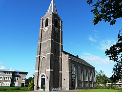
started to attract industry. In the late 1930s, the canal was diverted and a little harbour was created which further stimulated development.
307:
130:
866:
396:
737:
830:
742:
747:
65:
752:
215:
823:
491:
55:
567:
40:
757:
351:
856:
775:
322:
356:
807:
350:
Protestant church was built in 1883. Its location along the canal which is nowadays called
438:
712:
702:
687:
668:
850:
610:
330:
246:
241:
636:
507:
653:
720:
658:
338:
208:
203:
625:
181:
168:
803:
692:
533:
334:
227:
222:
795:
562:
672:
663:
697:
677:
645:
466:
579:
583:
574:
811:
730:
711:
644:
617:
306:
294:
286:
278:
273:
265:
257:
252:
233:
214:
197:
21:
341:. It had a population of around 2500 in 2017.
831:
595:
8:
838:
824:
602:
588:
580:
18:
425:
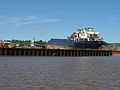
414:Sunrise being scrapped in Kootstertille
368:
293:
272:
264:
251:
196:
161:
89:
77:
49:
37:
433:
431:
429:
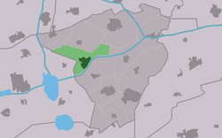
85:Location in Achtkarspelen municipality
508:"Kootstertille - (geografische naam)"
305:
285:
277:
256:
232:
213:
137:
104:
7:
792:
790:
439:"Kerncijfers wijken en buurten 2021"
261:7.80 km (3.01 sq mi)
810:. You can help Knowledge (XXG) by
14:
16:Village in Friesland, Netherlands
794:
771:
770:
635:
561:
407:
395:
383:
371:
240:
221:
202:
136:
129:
103:
96:
79:
64:
54:
39:
473:(in Dutch). Het Waterschapshuis
471:Actueel Hoogtebestand Nederland
575:website gemeente Achtkarspelen
1:
862:Populated places in Friesland
443:Central Bureau of Statistics
150:Kootstertille (Netherlands)
117:Location in the Netherlands
883:
789:
867:Friesland geography stubs
766:
633:
467:"Postcodetool for 9288AA"
162:
90:
78:
50:
38:
31:
269:0.7 m (2.3 ft)
738:Church of Augustinusga
290:310/km (810/sq mi)
153:Show map of Netherlands
806:location article is a
352:Prinses Margrietkanaal
326:
743:Church of Buitenpost
618:Administrative centre
570:at Wikimedia Commons
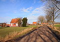
378:Farm in Kootstertille
120:Show map of Friesland
402:Former dairy factory
287: • Density
748:Church of Drogeham
390:Little houses/farms
333:in the province of
178: /
753:Church of Twijzel
329:) is a village in
279: • Total
258: • Total
819:
818:
784:
783:
566:Media related to
316:
315:
874:
840:
833:
826:
798:
791:
774:
773:
639:
604:
597:
590:
581:
565:
550:
549:
547:
545:
530:
524:
523:
521:
519:
504:
498:
497:
494:- Achtkarspelen
489:
483:
482:
480:
478:
463:
457:
456:
451:
449:
435:
411:
399:
387:
375:
360:
245:
244:
226:
225:
207:
206:
193:
192:
190:
189:
188:
183:
182:53.217°N 6.100°E
179:
176:
175:
174:
171:
154:
140:
139:
133:
121:
107:
106:
100:
83:
68:
58:
43:
19:
882:
881:
877:
876:
875:
873:
872:
871:
847:
846:
845:
844:
787:
785:
780:
762:
726:
707:
640:
631:
613:
608:
559:
554:
553:
543:
541:
534:"Kootstertille"
532:
531:
527:
517:
515:
506:
505:
501:
495:
490:
486:
476:
474:
465:
464:
460:
447:
445:
437:
436:
427:
422:
415:
412:
403:
400:
391:
388:
379:
376:
367:
354:
347:
302:
239:
220:
201:
186:
184:
180:
177:
172:
169:
167:
165:
164:
158:
157:
156:
155:
152:
151:
148:
147:
146:
145:
141:
124:
123:
122:
119:
118:
115:
114:
113:
112:
108:
86:
74:
73:
72:
71:
62:
61:
46:
45:Benedict Church
34:
27:
24:
17:
12:
11:
5:
880:
878:
870:
869:
864:
859:
849:
848:
843:
842:
835:
828:
820:
817:
816:
799:
782:
781:
779:
778:
767:
764:
763:
761:
760:
755:
750:
745:
740:
734:
732:
728:
727:
725:
724:
717:
715:
709:
708:
706:
705:
703:Twijzelerheide
700:
695:
690:
688:Surhuisterveen
685:
680:
675:
669:Gerkesklooster
666:
661:
656:
650:
648:
642:
641:
634:
632:
630:
629:
621:
619:
615:
614:
609:
607:
606:
599:
592:
584:
578:
577:
558:
557:External links
555:
552:
551:
525:
512:Etymologiebank
499:
484:
458:
424:
423:
421:
418:
417:
416:
413:
406:
404:
401:
394:
392:
389:
382:
380:
377:
370:
366:
363:
346:
343:
314:
313:
310:
304:
303:
300:
298:
292:
291:
288:
284:
283:
280:
276:
275:
271:
270:
267:
263:
262:
259:
255:
254:
250:
249:
237:
231:
230:
218:
212:
211:
199:
195:
194:
160:
159:
149:
143:
142:
135:
134:
128:
127:
126:
125:
116:
110:
109:
102:
101:
95:
94:
93:
92:
91:
88:
87:
84:
76:
75:
69:
63:
59:
53:
52:
51:
48:
47:
44:
36:
35:
32:
29:
28:
25:
22:
15:
13:
10:
9:
6:
4:
3:
2:
879:
868:
865:
863:
860:
858:
857:Achtkarspelen
855:
854:
852:
841:
836:
834:
829:
827:
822:
821:
815:
813:
809:
805:
800:
797:
793:
788:
777:
769:
768:
765:
759:
756:
754:
751:
749:
746:
744:
741:
739:
736:
735:
733:
729:
722:
719:
718:
716:
714:
710:
704:
701:
699:
696:
694:
691:
689:
686:
684:
683:Kootstertille
681:
679:
676:
674:
670:
667:
665:
662:
660:
657:
655:
652:
651:
649:
647:
643:
638:
628:
627:
623:
622:
620:
616:
612:
611:Achtkarspelen
605:
600:
598:
593:
591:
586:
585:
582:
576:
573:
572:
571:
569:
568:Kootstertille
564:
556:
539:
535:
529:
526:
513:
509:
503:
500:
493:
488:
485:
472:
468:
462:
459:
455:
444:
440:
434:
432:
430:
426:
419:
410:
405:
398:
393:
386:
381:
374:
369:
364:
362:
358:
353:
344:
342:
340:
336:
332:
331:Achtkarspelen
328:
327:Koatstertille
324:
320:
319:Kootstertille
311:
309:
299:
297:
289:
281:
268:
260:
248:
247:Achtkarspelen
243:
238:
236:
229:
224:
219:
217:
210:
205:
200:
191:
187:53.217; 6.100
163:Coordinates:
144:Kootstertille
132:
111:Kootstertille
99:
82:
67:
57:
42:
30:
26:Koatstertille
23:Kootstertille
20:
812:expanding it
801:
786:
682:
654:Augustinusga
624:
560:
542:. Retrieved
538:Plaatsengids
537:
528:
516:. Retrieved
511:
502:
487:
475:. Retrieved
470:
461:
453:
446:. Retrieved
442:
348:
323:West Frisian
318:
317:
308:Dialing code
235:Municipality
70:Coat of arms
723:(partially)
659:Boelenslaan
454:two entries
355: [
339:Netherlands
296:Postal code
209:Netherlands
185: /
851:Categories
626:Buitenpost
540:(in Dutch)
514:(in Dutch)
496:(in Dutch)
420:References
274:Population
804:Friesland
731:Landmarks
693:Surhuizum
335:Friesland
266:Elevation
228:Friesland
776:Category
758:De Mûnts
721:Kûkherne
673:Stroobos
664:Drogeham
646:Villages
544:29 March
518:29 March
492:Villages
477:29 March
448:29 March
216:Province
713:Hamlets
698:Twijzel
678:Harkema
365:Gallery
345:History
198:Country
170:53°13′N
33:Village
337:, the
173:6°06′E
802:This
359:]
282:2,425
808:stub
546:2022
520:2022
479:2022
450:2022
312:0512
301:9288
253:Area
60:Flag
853::
536:.
510:.
469:.
452:.
441:.
428:^
357:nl
325::
839:e
832:t
825:v
814:.
671:-
603:e
596:t
589:v
548:.
522:.
481:.
321:(
Text is available under the Creative Commons Attribution-ShareAlike License. Additional terms may apply.