170:
206:
194:
182:
104:
20:
320:
169:
380:
205:
193:
281:
181:
361:
62:, and as a whole complex with fortifications on the Hungarian side of the Danube it is the biggest fortification in former
400:
390:
395:
91:
354:
63:
76:
103:
274:
UNESCO: System of
Fortifications at the Confluence of the Rivers Danube and Váh in Komárno - Komárom
385:
141:
347:
155:
247:"System of Fortifications at the Confluence of the Rivers Danube and Váh in Komárno - Komárom"
47:
331:
225:
19:
374:
327:
124:
35:
273:
246:
58:
rivers. The fortification system of town Komárno is the biggest fortification in
131:
43:
39:
296:
283:
319:
59:
110:
City fortifications (with 16 large bastions and interconnecting walls):
149:
31:
135:
80:
51:
84:
55:
102:
18:
335:
121:
Váh bridge-head on the left bank of Váh (and Danube).
355:
8:
362:
348:
237:
165:
28:Komárno - Komárom fortification system
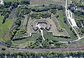
152:meaning "star" in Hungarian language)
7:
316:
314:
90:Old Fortress strengthened after the
381:Buildings and structures in Komárno
334:. You can help Knowledge (XXG) by
14:
318:
204:
192:
180:
168:
245:Centre, UNESCO World Heritage.
175:Ferdinand Gate of Old Fortress
46:(they were one town until the
1:
97:New Fortress built from 1658.
251:UNESCO World Heritage Centre
211:Barrack of the New Fortress
50:) on the banks of both the
38:in and around the towns of
417:
313:
107:Entrance of Fort Monostor
16:Fortification in Slovakia
199:Fort Igmánd from the sky
64:Austro-Hungarian Empire
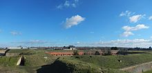
23:Old Fortress in Komárno
326:This military base or
108:
30:is a system of forts,
24:
134:on the right bank of
106:
79:at the confluence of
22:
401:Fortification stubs
297:47.7533°N 18.1375°E
293: /
77:Fortress of Komárno
109:
25:
391:Forts in Slovakia
343:
342:
48:treaty of Trianon
408:
396:Forts in Hungary
364:
357:
350:
322:
315:
308:
307:
305:
304:
303:
302:47.7533; 18.1375
298:
294:
291:
290:
289:
286:
261:
260:
258:
257:
242:
208:
196:
184:
172:
416:
415:
411:
410:
409:
407:
406:
405:
371:
370:
369:
368:
311:
301:
299:
295:
292:
287:
284:
282:
280:
279:
270:
265:
264:
255:
253:
244:
243:
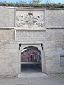
239:
234:
222:
216:
212:
209:
200:
197:
188:
185:
176:
173:
164:
128:(Fort Sandberg)
92:Mongol Invasion
72:
17:
12:
11:
5:
414:
412:
404:
403:
398:
393:
388:
383:
373:
372:
367:
366:
359:
352:
344:
341:
340:
323:
277:
276:
269:
268:External links
266:
263:
262:
236:
235:
233:
230:
229:
228:
221:
218:
214:
213:
210:
203:
201:
198:
191:
189:
186:
179:
177:
174:
167:
163:
160:
159:
158:
153:
139:
122:
119:
118:
117:
114:
113:Palatinus Line
100:
99:
98:
95:
71:
68:
36:fortifications
15:
13:
10:
9:
6:
4:
3:
2:
413:
402:
399:
397:
394:
392:
389:
387:
384:
382:
379:
378:
376:
365:
360:
358:
353:
351:
346:
345:
339:
337:
333:
330:article is a
329:
328:fortification
324:
321:
317:
312:
309:
306:
275:
272:
271:
267:
252:
248:
241:
238:
231:
227:
226:Klapka Induló
224:
223:
219:
217:
207:
202:
195:
190:
183:
178:
171:
166:
161:
157:
154:
151:
147:
146:the Star Fort
143:
140:
137:
133:
129:
126:
125:Fort Monostor
123:
120:
115:
112:
111:
105:
101:
96:
93:
89:
88:
86:
82:
78:
74:
73:
69:
67:
65:
61:
57:
53:
49:
45:
41:
37:
33:
29:
21:
336:expanding it
325:
310:
278:
254:. Retrieved
250:
240:
215:
187:Fort Csillag
145:
142:Fort Csillag
127:
75:The central
27:
26:
300: /
156:Fort Igmánd
375:Categories
288:18°08′15″E
285:47°45′12″N
256:2024-06-26
232:References
70:Components
220:See also
162:Pictures
116:Váh Line
94:in 1242.
87:rivers:
60:Slovakia
32:bastions
386:Komárom
150:csillag
132:Komárom
44:Komárom
40:Komárno
136:Danube
81:Danube
52:Danube
34:, and
332:stub
83:and
54:and
42:and
130:in
85:Váh
56:Váh
377::
249:.
148:,
66:.
363:e
356:t
349:v
338:.
259:.
144:(
138:.
Text is available under the Creative Commons Attribution-ShareAlike License. Additional terms may apply.