198:
26:
183:
228:
213:
197:
130:
Due to its length and altitude, Kom–Emine counts among Europe's longest uninterrupted high-mountain trails; it is
Bulgaria's longest, oldest and most famous hiking trail. Kom–Emine forms part of the wider
164:, who was unable to embark on the hike before his assassination. The first mass through-hike was done in 1953 and the first winter crossing on ski followed in 1961. Bulgarian extreme runner
153:
and around 30 mountain huts provide accommodation to hikers. Summer is the preferred season to walk Kom–Emine, though the lowest, eastern parts of the trail can get uncomfortably hot.
297:
146:(2,376 m (7,795 ft)), which is also the highest summit of the Balkan Mountains. In total, around 100 individual peaks are either summited or circumvented.
227:
441:
347:
182:
431:
436:
328:
168:
holds the record for the fastest crossing of Kom–Emine. In August 2018, he completed the route in 4 days, 8 hours 37 minutes .
132:
31:
401:
212:
138:
The trail's average elevation is 735 m (2,411 ft). The middle section, Kom–Emine's highest, coincides with the
204:
139:
426:
120:
25:
376:
165:
149:
Typically, the Kom–Emine hike takes 20 to 25 days to complete. The route is marked by white-red-white
157:
96:
161:
88:
324:
104:
50:
142:
and regularly rises above 2,000 m (6,600 ft). The highest point of the trail is
160:, though a route along the entire Balkan Mountains had already been conceived by writer
420:
405:
150:
119:, Kom–Emine continues east for some 650 km (400 mi) until it reaches the
233:
218:
143:
124:
75:
64:
272:
237:
188:
156:
The trail was first successfully traversed in 1933 by the hiking pioneer
112:
100:
54:
348:"Bulgarian Mountain Runner Sets New Record on Completing Kom-Emine Hike"
108:
116:
203:
Kom–Emine follows the main ridge of the Balkan
Mountains within the
115:(2,016 m (6,614 ft)) in the west near the border with
410:
71:
60:
46:
38:
18:
298:"International Hiking Trail E3 – Kom – Emine"
273:"European Long Distance Walking Paths in Bulgaria"
292:
290:
342:
340:
30:Kom–Emine forms the Bulgarian section of the
8:
266:
264:
262:
260:
258:
103:. The route follows the main ridge of the
370:
368:
107:, which bisect the country and give the
254:
178:
15:
323:(in Bulgarian). Домино. p. 293.
7:
14:
442:1930s establishments in Bulgaria
377:"От връх Ком до нос Емине (Е-3)"
226:
211:
196:
181:
24:
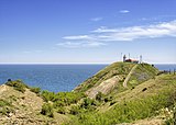
240:at Kom–Emine's eastern terminus
191:at Kom–Emine's western terminus
411:Website dedicated to Kom–Emine
379:(in Bulgarian). Planinite.info
300:. Central Balkan National Park
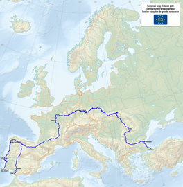
133:E3 European long distance path
67:, 2,376 m (7,795 ft)
32:E3 European long distance path
1:
432:European long-distance paths
205:Central Balkan National Park
140:Central Balkan National Park
271:Grancharov, Lyuben (2011).
221:, Kom–Emine's highest point
458:
375:Новаков, Красимир (2008).
437:Hiking trails in Bulgaria
319:Цветанов, Момчил (2014).
121:Bulgarian Black Sea Coast
92:
78:, 61 m (200 ft)
42:650 km (404 mi)
23:
275:. Hiking Guide Bulgaria
111:its name. Beginning at
95:) is a high-mountain
402:Kom–Emine route map
321:Българските планини
97:long-distance trail
162:Aleko Konstantinov
93:„Ком – Емине“
82:
81:
449:
427:Balkan mountains
389:
388:
386:
384:
372:
363:
362:
360:
358:
344:
335:
334:
316:
310:
309:
307:
305:
294:
285:
284:
282:
280:
268:
230:
215:
200:
185:
166:Bozhidar Antonov
109:Balkan Peninsula
105:Balkan Mountains
94:
51:Balkan Mountains
28:
16:
457:
456:
452:
451:
450:
448:
447:
446:
417:
416:
398:
393:
392:
382:
380:
374:
373:
366:
356:
354:
346:
345:
338:
331:
318:
317:
313:
303:
301:
296:
295:
288:
278:
276:
270:
269:
256:
251:
246:
245:
244:
241:
231:
222:
216:
207:
201:
192:
186:
174:
158:Pavel Deliradev
34:
12:
11:
5:
455:
453:
445:
444:
439:
434:
429:
419:
418:
415:
414:
413:(in Bulgarian)
408:
397:
396:External links
394:
391:
390:
364:
336:
329:
311:
286:
253:
252:
250:
247:
243:
242:
232:
225:
223:
217:
210:
208:
202:
195:
193:
187:
180:
177:
176:
175:
173:
170:
151:paint markings
80:
79:
73:
69:
68:
62:
58:
57:
48:
44:
43:
40:
36:
35:
29:
21:
20:
13:
10:
9:
6:
4:
3:
2:
454:
443:
440:
438:
435:
433:
430:
428:
425:
424:
422:
412:
409:
407:
406:OpenStreetMap
403:
400:
399:
395:
378:
371:
369:
365:
353:
349:
343:
341:
337:
332:
330:9789546512499
326:
322:
315:
312:
299:
293:
291:
287:
274:
267:
265:
263:
261:
259:
255:
248:
239:
235:
229:
224:
220:
214:
209:
206:
199:
194:
190:
184:
179:
171:
169:
167:
163:
159:
154:
152:
147:
145:
141:
136:
134:
128:
126:
122:
118:
114:
110:
106:
102:
98:
90:
86:
77:
74:
70:
66:
63:
61:Highest point
59:
56:
52:
49:
45:
41:
37:
33:
27:
22:
17:
381:. Retrieved
355:. Retrieved
352:Novinite.com
351:
320:
314:
302:. Retrieved
277:. Retrieved
155:
148:
137:
129:
84:
83:
72:Lowest point
383:15 February
357:15 February
304:15 February
279:15 February
421:Categories
249:References
234:Cape Emine
219:Botev Peak
144:Botev Peak
125:Cape Emine
76:Cape Emine
65:Botev Peak
238:Black Sea
89:Bulgarian
85:Kom–Emine
19:Kom–Emine
236:and the
189:Kom Peak
113:Kom Peak
101:Bulgaria
55:Bulgaria
47:Location
172:Gallery
327:
117:Serbia
39:Length
385:2016
359:2016
325:ISBN
306:2016
281:2016
404:at
123:at
99:in
423::
367:^
350:.
339:^
289:^
257:^
135:.
127:.
91::
53:,
387:.
361:.
333:.
308:.
283:.
87:(
Text is available under the Creative Commons Attribution-ShareAlike License. Additional terms may apply.