78:
66:
94:
51:
430:
950:
802:
587:
575:
599:
611:
101:
335:
410:
base that does not allow the formation of surface water flows such as rivers and streams, the water instead forms flows in underground rivers that sometimes rise to the surface in the
77:
125:
844:
65:
768:
1160:
888:
790:
756:
884:
868:
864:
1079:
93:
738:
904:
282:
384:
1125:
50:
825:
341:
373:
914:
369:
783:
874:
377:
1043:
976:
924:
716:
345:
244:
220:
41:
586:
574:
526:
357:
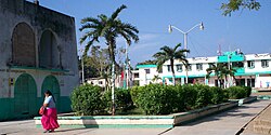
754:
INEGI. Instituto
Nacional de Estadística y Geografía. Censo de Población y Vivienda 1995, 2000, 2005, 2010.
17:
858:
776:
184:
834:
938:
753:
426:), as well as 81 unpopulated localities. The largest localities (cities, towns, and villages) are:
388:
361:
934:
598:
429:
365:
986:
981:
949:
403:, Lázaro Cárdenas is entirely flat with a gentle slope towards the sea, so from west to east.
400:
1084:
971:
928:
610:
356:, which was founded on 10 October 1859. Its borders are, to the west, the municipalities of
328:
167:
760:
742:
720:
735:
918:
898:
450:
353:
194:
1154:
552:
1120:
878:
807:
801:
349:
172:
1110:
1007:
1002:
1063:
1023:
263:
140:
127:
1135:
1115:
1033:
407:
273:
848:
1105:
908:
816:
179:
854:
838:
640:
414:. Lakes and cenotes are the major bodies of water in the municipality.
1130:
1100:
1053:
468:
411:
160:
713:
305:
1058:
1048:
1038:
428:
290:
278:
1028:
772:
635:
691:
Source: INEGI Instituto
Nacional de Estadística y Geografía
406:
Like the rest of the peninsula's surface, the land has a
422:
The municipality is made up of 82 populated localities (
1093:
1072:
1016:
995:
964:
957:
824:
300:
289:
272:
261:
253:
242:
237:
229:
218:
213:
205:
200:
190:
178:
166:
156:
32:
784:
8:
626:
731:
729:
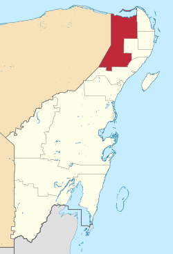
82:Location of Lázaro Cárdenas in Quintana Roo
961:
791:
777:
769:
709:
707:
625:
436:
29:
18:Lázaro Cárdenas Municipality, Quintana Roo
703:
570:
299:
288:
271:
236:
228:
212:
199:
189:
155:
120:
100:
86:
74:
59:
47:
327:
260:
252:
241:
225:3,881 km (1,498 sq mi)
217:
204:
177:
165:
7:
433:Map of Lazaro Cardenas, Municipality
368:, to the east the municipalities of
352:. Its municipal seat is the town of
27:Municipality in Quintana Roo, Mexico
1080:Arrecifes de Cozumel National Park
25:
948:
800:
609:
597:
585:
573:
206: • Municipal President
99:
92:
76:
64:
49:
714:El municipio de Lázaro Cárdenas
1161:Municipalities of Quintana Roo
1:
1177:
329:[ˈlasaɾoˈkaɾðenas]
55:Kantunil Kin central plaza
946:
814:
736:2010 census tables: INEGI
690:
653:—
121:
87:
75:
60:
48:
39:
977:Sistema Nohoch Nah Chich
385:Lázaro Cárdenas del Río
869:Felipe Carrillo Puerto
865:Felipe Carrillo Puerto
434:
257:7.5/km (19/sq mi)
233:20 m (70 ft)
113:Location within Mexico
859:San Miguel de Cozumel
627:Historical population
432:
342:eleven municipalities
283:Eastern Standard Time
254: • Density
628:
391:from 1934 to 1940.
389:President of Mexico
376:, and to the south
137: /
958:Places of interest
889:José María Morelos
885:José María Morelos
759:2013-09-28 at the
741:2013-05-02 at the
719:2008-02-14 at the
562:Total municipality
435:
383:It is named after
1148:
1147:
1144:
1143:
987:Sistema Sac Actun
982:Sistema Ox Bel Ha
695:
694:
569:
568:
401:Yucatan Peninsula
399:Like most of the
344:that make up the
318:
317:
209:Clementino Angulo
141:21.100°N 87.483°W
16:(Redirected from
1168:
1085:Banco Chinchorro
972:Sistema Dos Ojos
962:
952:
929:Playa del Carmen
805:
804:
793:
786:
779:
770:
763:
751:
745:
733:
724:
711:
642:
637:
629:
613:
601:
592:Nuevo Valladolid
589:
580:Ignacio Zaragoza
577:
486:Nuevo Valladolid
460:Ignacio Zaragoza
437:
364:in the state of
340:) is one of the
339:
338:
337:
331:
326:
314:
311:
309:
307:
152:
151:
149:
148:
147:
142:
138:
135:
134:
133:
130:
103:
102:
96:
80:
68:
53:
30:
21:
1176:
1175:
1171:
1170:
1169:
1167:
1166:
1165:
1151:
1150:
1149:
1140:
1089:
1068:
1012:
991:
953:
944:
905:Othón P. Blanco
895:Lázaro Cárdenas
820:
810:
799:
797:
767:
766:
761:Wayback Machine
752:
748:
743:Wayback Machine
734:
727:
721:Wayback Machine
712:
705:
700:
624:
617:
614:
605:
602:
593:
590:
581:
578:
444:
420:
397:
334:
333:
332:
324:
321:Lázaro Cárdenas
308:.lazarocardenas
304:
185:Lázaro Cárdenas
146:21.100; -87.483
145:
143:
139:
136:
131:
128:
126:
124:
123:
117:
116:
115:
114:
111:
110:
109:
108:
107:Lázaro Cárdenas
104:
83:
71:
70:
69:
56:
44:
35:
34:Lázaro Cárdenas
28:
23:
22:
15:
12:
11:
5:
1174:
1172:
1164:
1163:
1153:
1152:
1146:
1145:
1142:
1141:
1139:
1138:
1133:
1128:
1123:
1118:
1113:
1108:
1103:
1097:
1095:
1091:
1090:
1088:
1087:
1082:
1076:
1074:
1070:
1069:
1067:
1066:
1061:
1056:
1051:
1046:
1041:
1036:
1031:
1026:
1020:
1018:
1014:
1013:
1011:
1010:
1005:
999:
997:
993:
992:
990:
989:
984:
979:
974:
968:
966:
959:
955:
954:
947:
945:
943:
942:
932:
922:
919:Puerto Morelos
915:Puerto Morelos
912:
902:
892:
882:
872:
862:
852:
842:
831:
829:
826:Municipalities
822:
821:
815:
812:
811:
798:
796:
795:
788:
781:
773:
765:
764:
746:
725:
723:Official Site.
702:
701:
699:
696:
693:
692:
688:
687:
684:
681:
677:
676:
673:
670:
666:
665:
662:
659:
655:
654:
651:
648:
644:
643:
638:
633:
623:
620:
619:
618:
615:
608:
606:
603:
596:
594:
591:
584:
582:
579:
572:
567:
566:
563:
559:
558:
555:
549:
548:
545:
541:
540:
537:
533:
532:
529:
523:
522:
519:
515:
514:
511:
507:
506:
503:
499:
498:
495:
491:
490:
487:
483:
482:
479:
475:
474:
471:
465:
464:
461:
457:
456:
453:
447:
446:
445:(2010 Census)
441:
419:
416:
396:
393:
316:
315:
302:
298:
297:
294:
287:
286:
276:
270:
269:
266:
259:
258:
255:
251:
250:
247:
240:
239:
235:
234:
231:
227:
226:
223:
216:
215:
211:
210:
207:
203:
202:
198:
197:
192:
191:Municipal seat
188:
187:
182:
176:
175:
170:
164:
163:
158:
154:
153:
119:
118:
112:
106:
105:
98:
97:
91:
90:
89:
88:
85:
84:
81:
73:
72:
63:
62:
61:
58:
57:
54:
46:
45:
40:
37:
36:
33:
26:
24:
14:
13:
10:
9:
6:
4:
3:
2:
1173:
1162:
1159:
1158:
1156:
1137:
1134:
1132:
1129:
1127:
1124:
1122:
1119:
1117:
1114:
1112:
1109:
1107:
1104:
1102:
1099:
1098:
1096:
1092:
1086:
1083:
1081:
1078:
1077:
1075:
1071:
1065:
1062:
1060:
1057:
1055:
1052:
1050:
1047:
1045:
1042:
1040:
1037:
1035:
1032:
1030:
1027:
1025:
1022:
1021:
1019:
1015:
1009:
1006:
1004:
1001:
1000:
998:
994:
988:
985:
983:
980:
978:
975:
973:
970:
969:
967:
963:
960:
956:
951:
940:
936:
933:
930:
926:
923:
920:
916:
913:
910:
906:
903:
900:
896:
893:
890:
886:
883:
880:
876:
873:
870:
866:
863:
860:
856:
853:
850:
846:
845:Benito Juárez
843:
840:
836:
833:
832:
830:
827:
823:
818:
813:
809:
803:
794:
789:
787:
782:
780:
775:
774:
771:
762:
758:
755:
750:
747:
744:
740:
737:
732:
730:
726:
722:
718:
715:
710:
708:
704:
697:
689:
685:
682:
679:
678:
674:
671:
668:
667:
663:
660:
657:
656:
652:
649:
646:
645:
639:
634:
631:
630:
621:
612:
607:
600:
595:
588:
583:
576:
571:
564:
561:
560:
556:
554:
553:Nuevo Durango
551:
550:
546:
543:
542:
538:
536:San Francisco
535:
534:
530:
528:
525:
524:
520:
517:
516:
512:
509:
508:
504:
501:
500:
496:
493:
492:
488:
485:
484:
480:
477:
476:
472:
470:
467:
466:
462:
459:
458:
454:
452:
449:
448:
442:
439:
438:
431:
427:
425:
417:
415:
413:
409:
404:
402:
394:
392:
390:
386:
381:
379:
375:
374:Benito Juárez
371:
367:
363:
359:
355:
351:
347:
346:Mexican state
343:
336:
330:
322:
313:
303:
295:
292:
284:
280:
277:
275:
267:
265:
262: •
256:
248:
246:
243: •
232:
224:
222:
219: •
208:
196:
193:
186:
183:
181:
174:
171:
169:
162:
159:
150:
122:Coordinates:
95:
79:
67:
52:
43:
38:
31:
19:
1121:Riviera Maya
1044:San Gervasio
894:
879:Isla Mujeres
875:Isla Mujeres
808:Quintana Roo
749:
622:Demographics
423:
421:
405:
398:
382:
370:Isla Mujeres
350:Quintana Roo
320:
319:
245:Municipality
221:Municipality
173:Quintana Roo
42:Municipality
1111:Punta Allen
1008:Isla Holbox
1003:Isla Contoy
925:Solidaridad
899:Kantunilkín
604:Nuevo X-Can
451:Kantunilkín
424:localidades
418:Communities
378:Solidaridad
354:Kantunilkín
195:Kantunilkín
144: /
1126:Sian Kaʼan
1024:Chacchoben
1017:Maya sites
698:References
494:Nuevo Xcán
443:Population
238:Population
201:Government
1136:Yum Balam
1116:Punta Sur
1034:Kohunlich
819:(capital)
806:State of
616:El Tintal
544:El Cedral
527:Solferino
510:San Ángel
502:El Tintal
408:limestone
395:Geography
274:Time zone
230:Elevation
180:Named for
1155:Category
1106:Mahahual
909:Chetumal
817:Chetumal
757:Archived
739:Archived
717:Archived
518:El Ideal
478:Chiquilá
387:who was
325:Spanish:
1064:Yo'okop
996:Islands
855:Cozumel
839:Bacalar
835:Bacalar
828:(seats)
641:±% p.a.
565:25,333
412:cenotes
366:Yucatán
358:Tizimín
301:Website
157:Country
132:87°29′W
129:21°06′N
1131:Xcalak
1101:Akumal
1054:Xcaret
849:Cancún
686:+2.46%
683:25,333
675:+1.91%
672:22,434
664:+2.20%
661:20,411
650:18,307
513:1,041
505:1,074
497:1,130
489:1,294
481:1,466
473:1,486
469:Holbox
463:2,213
455:7,150
362:Chemax
249:29,171
161:Mexico
1094:Other
1073:Reefs
1059:Xelha
1049:Tulum
1039:Muyil
965:Caves
939:Tulum
935:Tulum
680:2010
669:2005
658:2000
647:1995
296:23007
291:INEGI
279:UTC-5
268:7,150
264:Urban
168:State
1029:Coba
636:Pop.
632:Year
557:225
547:752
539:767
531:799
521:818
440:Name
372:and
360:and
310:.gob
293:Code
214:Area
348:of
312:.mx
306:www
1157::
728:^
706:^
380:.
941:)
937:(
931:)
927:(
921:)
917:(
911:)
907:(
901:)
897:(
891:)
887:(
881:)
877:(
871:)
867:(
861:)
857:(
851:)
847:(
841:)
837:(
792:e
785:t
778:v
323:(
285:)
281:(
20:)
Text is available under the Creative Commons Attribution-ShareAlike License. Additional terms may apply.