49:
643:
67:
523:
135:
285:
74:
312:, and in 1796 most of the abbey's surrounding property was confiscated by the Prussian government. In 1807, the village was regained by Poles and included within the short-lived
459:
Rozporządzenie
Prezydenta Rzeczypospolitej polskiej z dnia 17 czerwca 2009 r. w sprawie uznania za pomnik historii "Zespół dawnego opactwa cysterskiego w Lądzie nad Wartą"
353:
95:
684:
617:
708:
489:
607:
703:
557:
361:
340:
562:
597:
592:
552:
445:
677:
327:, Poland regained independence and control of the village, and from 1921 the abbey has been operated and maintained by the
371:
66:
482:
226:
547:
670:
48:
587:
512:
309:
265:
234:
152:
348:
522:
423:
127:
542:
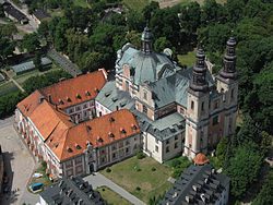
300:. Founded about 1150 one kilometer south of the village center, it is one of the seven daughter houses of the
475:
336:
387:
328:
147:
408:"Central Statistical Office (GUS) - TERYT (National Register of Territorial Land Apportionment Journal)"
205:
458:
215:
343:(World War II), at the turn of 1939 and 1940, the occupiers imprisoned arrested Polish priests from
612:
407:
305:
304:. Its major buildings date from the 16th and 17th centuries. In 1793 the village was annexed by
642:
317:
650:
567:
383:
261:
164:
427:
366:
313:
301:
249:
537:
344:
654:
577:
498:
257:
176:
697:
622:
442:
Był rok 1939. Operacja niemieckiej policji bezpieczeństwa w Polsce. Intelligenzaktion
332:
268:, in west-central Poland. It lies approximately 12 kilometres (7 mi) south of
297:
53:
324:
293:
110:
97:
602:
196:
273:
269:
582:
284:
253:
222:
201:
159:
140:
420:
17:
283:
171:
471:
467:
316:. Following the duchy's dissolution in 1815, Ląd fell to the
272:
and 71 km (44 mi) east of the regional capital
658:
320:, and in 1819 the Cistercian monastery was dissolved.
530:
505:
370:), as designated on 1 July 2009 and tracked by the
233:
212:
195:
187:
182:
170:
158:
146:
126:
32:
347:in the abbey, and afterwards deported them to the
354:Nazi persecution of the Catholic Church in Poland
339:served there as a tutor in the 1920s. During the
360:The abbey is one of Poland's official national
678:
483:
27:Village in Greater Poland Voivodeship, Poland
8:
685:
671:
490:
476:
468:
29:
399:
232:
194:
181:
125:
90:
59:
45:
386:467 passes through Ląd and the Polish
211:
186:
169:
157:
145:
7:
639:
637:
390:runs nearby, north of the village.
461:, Dz. U., 2009, vol. 104, No. 861
256:in the administrative district of
25:
421:http://www.lad.pl/lad_deutsch.pdf
372:National Heritage Board of Poland
292:The village is the location of a
641:
521:
351:, where most of them died (see:
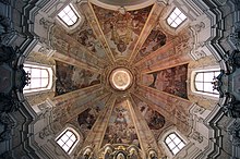
288:Interior of the monastery church
248:
133:
72:
65:
47:
1:
709:Słupca County geography stubs
657:. You can help Knowledge by
341:German occupation of Poland
73:
725:
636:
440:Wardzyńska, Maria (2009).
310:Second Partition of Poland
266:Greater Poland Voivodeship
704:Villages in Słupca County
519:
349:Dachau concentration camp
91:
60:
46:
39:
410:(in Polish). 2008-06-01.
337:Kazimierz Wojciechowski
653:location article is a
329:Salesians of Don Bosco
289:
444:(in Polish). Warsaw:
287:
214: • Summer (
235:Vehicle registration
107: /
426:2013-12-02 at the
362:Historic Monuments
290:
188: • Total
666:
665:
631:
630:
430:(German language)
318:Russian Partition
243:
242:
111:52.200°N 17.900°E
16:(Redirected from
716:
687:
680:
673:
645:
638:
613:Sługocin-Kolonia
568:Jaroszyn-Kolonia
525:
492:
485:
478:
469:
462:
456:
450:
449:
437:
431:
418:
412:
411:
404:
384:Voivodeship road
280:Cistercian Abbey
251:
219:
139:
137:
136:
122:
121:
119:
118:
117:
112:
108:
105:
104:
103:
100:
76:
75:
69:
51:
30:
21:
724:
723:
719:
718:
717:
715:
714:
713:
694:
693:
692:
691:
634:
632:
627:
543:Ciążeń-Holendry
526:
517:
501:
496:
466:
465:
457:
453:
439:
438:
434:
428:Wayback Machine
419:
415:
406:
405:
401:
396:
380:
367:Pomnik historii
314:Duchy of Warsaw
302:Altenberg Abbey
296:monastery, the
282:
213:
134:
132:
115:
113:
109:
106:
101:
98:
96:
94:
93:
87:
86:
85:
84:
83:
82:
81:
77:
56:
42:
35:
28:
23:
22:
15:
12:
11:
5:
722:
720:
712:
711:
706:
696:
695:
690:
689:
682:
675:
667:
664:
663:
646:
629:
628:
626:
625:
620:
615:
610:
605:
600:
595:
590:
585:
580:
575:
570:
565:
560:
555:
550:
545:
540:
534:
532:
531:Other villages
528:
527:
520:
518:
516:
515:
509:
507:
503:
502:
497:
495:
494:
487:
480:
472:
464:
463:
451:
448:. p. 209.
432:
413:
398:
397:
395:
392:
379:
376:
281:
278:
241:
240:
237:
231:
230:
220:
210:
209:
199:
193:
192:
189:
185:
184:
180:
179:
174:
168:
167:
162:
156:
155:
153:Greater Poland
150:
144:
143:
130:
124:
123:
116:52.200; 17.900
89:
88:
79:
78:
71:
70:
64:
63:
62:
61:
58:
57:
52:
44:
43:
40:
37:
36:
33:
26:
24:
14:
13:
10:
9:
6:
4:
3:
2:
721:
710:
707:
705:
702:
701:
699:
688:
683:
681:
676:
674:
669:
668:
662:
660:
656:
652:
651:Słupca County
647:
644:
640:
635:
624:
623:Wola Koszucka
621:
619:
616:
614:
611:
609:
606:
604:
601:
599:
596:
594:
591:
589:
586:
584:
581:
579:
576:
574:
571:
569:
566:
564:
561:
559:
556:
554:
551:
549:
546:
544:
541:
539:
536:
535:
533:
529:
524:
514:
511:
510:
508:
504:
500:
493:
488:
486:
481:
479:
474:
473:
470:
460:
455:
452:
447:
443:
436:
433:
429:
425:
422:
417:
414:
409:
403:
400:
393:
391:
389:
385:
377:
375:
373:
369:
368:
363:
358:
356:
355:
350:
346:
342:
338:
334:
331:. The Polish
330:
326:
321:
319:
315:
311:
307:
303:
299:
295:
286:
279:
277:
275:
271:
267:
263:
262:Słupca County
259:
255:
250:
247:
238:
236:
228:
224:
221:
217:
207:
203:
200:
198:
190:
178:
175:
173:
166:
163:
161:
154:
151:
149:
142:
131:
129:
120:
92:Coordinates:
68:
55:
50:
38:
31:
19:
659:expanding it
648:
633:
572:
454:
441:
435:
416:
402:
381:
365:
359:
352:
333:World War II
322:
291:
245:
244:
578:Ląd-Kolonia
499:Gmina Lądek
388:A2 motorway
325:World War I
258:Gmina Lądek
148:Voivodeship
114: /
698:Categories
394:References
323:Following
294:Cistercian
183:Population
603:Samarzewo
558:Dziedzice
378:Transport
345:Włocławek
298:Ląd Abbey
260:, within
197:Time zone
54:Ląd Abbey
618:Wacławów
608:Sługocin
588:Piotrowo
583:Nakielec
563:Jaroszyn
424:Archived
593:Policko
548:Dąbrowa
335:martyr
308:in the
306:Prussia
254:village
128:Country
102:17°54′E
99:52°12′N
41:Village
553:Dolany
538:Ciążeń
274:Poznań
270:Słupca
165:Słupca
160:County
141:Poland
138:
649:This
598:Ratyń
513:Lądek
252:is a
223:UTC+2
202:UTC+1
177:Lądek
172:Gmina
655:stub
506:Seat
382:The
227:CEST
573:Ląd
446:IPN
357:).
246:Ląd
239:PSL
216:DST
206:CET
80:Ląd
34:Ląd
18:Ląd
700::
374:.
276:.
264:,
191:60
686:e
679:t
672:v
661:.
491:e
484:t
477:v
364:(
229:)
225:(
218:)
208:)
204:(
20:)
Text is available under the Creative Commons Attribution-ShareAlike License. Additional terms may apply.