118:
158:
125:
151:
487:
473:), causing them to drop their moisture in the form of rain or snow onto the Cascades. As a result, Luahna Peak experiences high precipitation, especially during the winter months in the form of snowfall which feeds its glaciers. During winter months, weather is usually cloudy, but due to high pressure systems over the Pacific Ocean that intensify during summer months, there is often little or no cloud cover during the summer with optimum weather for climbing Luahna from July through September.
446:
705:
722:
697:
680:
29:
428:
period dating back over two million years ago, glaciation advancing and retreating repeatedly scoured the landscape leaving deposits of rock debris. The U-shaped cross section of the river valleys is a result of recent glaciation.
386:. Geological events occurring many years ago created the diverse topography and drastic elevation changes over the Cascade Range leading to various climate differences.
769:
636:
507:
117:
73:
764:
150:
449:
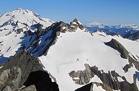
Luahna Peak from High Pass. True summit and Pilz
Glacier on left; Luahna's northwest summit (aka "Chalangin Peak") and Butterfly Glacier on right
784:
437:
in combination with glaciation have been the dominant processes which have created the tall peaks and deep valleys of the North
Cascades area.
322:
state. The true summit is 8,445 feet in elevation, and the northwest subpeak is 8,369 feet. The mountain is situated in Chelan County, in the
366:
of the summit was made on August 13, 1911, by Rodney Glisan, H.H. Prouty, Winthrop Stone, C.W. Whittlesey, all of whom were members of the
629:
502:
335:
245:
622:
736:
351:
66:
741:
327:
666:
330:
which is 1.04 mi (1.67 km) to the southeast, and Luahna lies 6.95 mi (11.18 km) southeast of
323:
205:
779:
410:
319:
311:
215:
195:
774:
56:
567:
Beckey, Fred W. Cascade Alpine Guide, Climbing and High Routes. Seattle, WA: Mountaineers Books, 2008.
394:
406:
389:
The history of the formation of the
Cascade Mountains dates back millions of years ago to the late
260:
656:
462:
454:
343:
731:
673:
492:
445:
470:
434:
359:
240:
466:
418:
383:
355:
347:
315:
229:
222:
758:
458:
398:
379:
307:
233:
689:
661:
363:
339:
331:
287:
277:
614:
711:
425:
536:
482:
294:
88:
75:
609:
603:
28:
430:
414:
402:
367:
378:
The North
Cascades features some of the most rugged topography in the
390:
265:
46:
618:
326:. Luahna Peak is the second highest in the Dakobed Range after
461:
originating in the
Pacific Ocean travel northeast toward the
608:
Luahna Peak's NW peak (aka "Chalangin Peak") aerial photo:
563:
561:
559:
557:
346:
stretching across the northern slope. Precipitation
286:
276:
271:
259:
254:
239:
221:
211:
201:
191:
183:
104:
65:
55:
45:
40:
21:
405:persisted. In addition, small fragments of the
338:lies to the southeast of the summit, with the
630:
16:Mountain in Washington (state), United States
8:
579:
577:
575:
573:
508:List of mountain peaks of Washington (state)
382:with craggy peaks, spires, ridges, and deep
637:
623:
615:
586:The Natural History of Puget Sound Country
18:
444:
519:
469:, they are forced upward by the peaks (
457:climate zone of western North America.
770:Mountains of Chelan County, Washington
7:
652:
531:
529:
527:
525:
523:
33:Luahna Peak seen from Clark Mountain
157:
124:
35:(Glacier Peak in upper left corner)
14:
588:. University of Washington Press.
720:
703:
695:
678:
485:
156:
149:
123:
116:
27:
765:Mountains of Washington (state)
503:Geography of the North Cascades
306:is an 8,445-foot (2,574-metre)
645:Places adjacent to Luahna Peak
453:Luahna Peak is located in the
350:from the peak drains into the
140:Show map of Washington (state)
1:
785:North American 2000 m summits
721:
679:
173:Show map of the United States
170:Location in the United States
704:
696:
421:about 50 million years ago.
51:8,445 ft (2,574 m)
584:Kruckeberg, Arthur (1991).
801:
602:Luahna Peak aerial photo:
358:, both tributaries of the
650:
537:"Luahna Peak, Washington"
465:. As fronts approach the
403:volcanic igneous activity
324:Wenatchee National Forest
109:
26:
310:mountain located in the
61:810 ft (247 m)
411:continental lithosphere
312:Glacier Peak Wilderness
216:Glacier Peak Wilderness
450:
137:Location in Washington
89:48.06056°N 120.98500°W
448:
395:North American Plate
94:48.06056; -120.98500
212:Protected area
85: /
451:
336:Richardson Glacier
297:and glacier travel
41:Highest point
752:
751:
747:
746:
657:Butterfly Glacier
463:Cascade Mountains
455:marine west coast
344:Butterfly Glacier
301:
300:
792:
732:Indian Head Peak
724:
723:
707:
706:
699:
698:
682:
681:
674:Tenpeak Mountain
653:
639:
632:
625:
616:
590:
589:
581:
568:
565:
552:
551:
549:
547:
533:
495:
493:Mountains portal
490:
489:
488:
393:Epoch. With the
290:
225:
174:
160:
159:
153:
141:
127:
126:
120:
100:
99:
97:
96:
95:
90:
86:
83:
82:
81:
78:
31:
19:
800:
799:
795:
794:
793:
791:
790:
789:
755:
754:
753:
748:
708:
646:
643:
599:
594:
593:
583:
582:
571:
566:
555:
545:
543:
535:
534:
521:
516:
499:
498:
491:
486:
484:
479:
471:orographic lift
443:
397:overriding the
384:glacial valleys
376:
360:Wenatchee River
288:
232:
223:
179:
178:
177:
176:
175:
172:
171:
168:
167:
166:
165:
161:
144:
143:
142:
139:
138:
135:
134:
133:
132:
128:
93:
91:
87:
84:
79:
76:
74:
72:
71:
36:
34:
17:
12:
11:
5:
798:
796:
788:
787:
782:
780:North Cascades
777:
772:
767:
757:
756:
750:
749:
745:
744:
742:Clark Mountain
739:
734:
728:
727:
725:
718:
715:
714:
709:
694:
692:
686:
685:
683:
676:
670:
669:
664:
659:
651:
648:
647:
644:
642:
641:
634:
627:
619:
613:
612:
606:
598:
597:External links
595:
592:
591:
569:
553:
541:Peakbagger.com
518:
517:
515:
512:
511:
510:
505:
497:
496:
481:
480:
478:
475:
467:North Cascades
459:Weather fronts
442:
439:
419:North Cascades
401:, episodes of
375:
372:
356:Napeequa River
328:Clark Mountain
316:North Cascades
299:
298:
292:
284:
283:
280:
274:
273:
269:
268:
263:
257:
256:
252:
251:
249:Clark Mountain
243:
237:
236:
230:North Cascades
227:
219:
218:
213:
209:
208:
203:
199:
198:
193:
189:
188:
185:
181:
180:
169:
163:
162:
155:
154:
148:
147:
146:
145:
136:
130:
129:
122:
121:
115:
114:
113:
112:
111:
110:
107:
106:
102:
101:
69:
63:
62:
59:
53:
52:
49:
43:
42:
38:
37:
32:
24:
23:
15:
13:
10:
9:
6:
4:
3:
2:
797:
786:
783:
781:
778:
776:
775:Cascade Range
773:
771:
768:
766:
763:
762:
760:
743:
740:
738:
735:
733:
730:
729:
726:
719:
717:
716:
713:
710:
702:
693:
691:
688:
687:
684:
677:
675:
672:
671:
668:
667:Buck Mountain
665:
663:
660:
658:
655:
654:
649:
640:
635:
633:
628:
626:
621:
620:
617:
611:
607:
605:
601:
600:
596:
587:
580:
578:
576:
574:
570:
564:
562:
560:
558:
554:
542:
538:
532:
530:
528:
526:
524:
520:
513:
509:
506:
504:
501:
500:
494:
483:
476:
474:
472:
468:
464:
460:
456:
447:
440:
438:
436:
432:
427:
422:
420:
416:
412:
408:
404:
400:
399:Pacific Plate
396:
392:
387:
385:
381:
380:Cascade Range
373:
371:
369:
365:
361:
357:
353:
349:
345:
341:
337:
333:
329:
325:
321:
317:
313:
309:
308:double summit
305:
296:
293:
291:
289:Easiest route
285:
281:
279:
275:
270:
267:
264:
262:
258:
253:
250:
247:
244:
242:
238:
235:
234:Cascade Range
231:
228:
226:
220:
217:
214:
210:
207:
204:
200:
197:
194:
190:
187:United States
186:
182:
152:
119:
108:
103:
98:
70:
68:
64:
60:
58:
54:
50:
48:
44:
39:
30:
25:
20:
700:
690:Kololo Peaks
662:Pilz Glacier
585:
544:. Retrieved
540:
452:
423:
417:created the
388:
377:
364:first ascent
340:Pilz Glacier
332:Glacier Peak
303:
302:
278:First ascent
261:Type of rock
248:
224:Parent range
737:White River
712:Brahma Peak
701:Luahna Peak
426:Pleistocene
424:During the
352:White River
304:Luahna Peak
164:Luahna Peak
131:Luahna Peak
92: /
80:120°59′06″W
67:Coordinates
22:Luahna Peak
759:Categories
514:References
320:Washington
295:Scrambling
196:Washington
77:48°03′38″N
57:Prominence
546:April 17,
105:Geography
47:Elevation
477:See also
435:faulting
415:terranes
272:Climbing
241:Topo map
441:Climate
413:called
407:oceanic
374:Geology
368:Mazamas
314:of the
255:Geology
184:Country
431:Uplift
391:Eocene
362:. The
348:runoff
334:. The
266:Schist
206:Chelan
202:County
610:PBase
604:PBase
192:State
548:2019
433:and
409:and
354:and
342:and
282:1911
246:USGS
318:in
761::
572:^
556:^
539:.
522:^
370:.
638:e
631:t
624:v
550:.
Text is available under the Creative Commons Attribution-ShareAlike License. Additional terms may apply.