1218:
responsible for raising and collecting local taxes and the budgets of the council are audited and submitted every year after the annual budget. The elected members of the council do not draw salaries, but are paid allowances from the council. Luapula is a predominantly rural province and there are no city or municipal councils. The government stipulates 63 different functions for the councils with the majority of them being infrastructure management and local administration. Councils are mandated to maintain each of their community centres, zoos, local parks, drainage system, playgrounds, cemeteries, caravan sites, libraries, museums and art galleries. They also work along with specific government departments to help in agriculture, conservation of natural resources, postal service, establishing and maintaining hospitals, schools and colleges. The councils prepare schemes that encourage community participation.
1227:
275:
904:, Luapula Province had a population of 991,927 which accounted for 7.57 per cent of the total Zambian population of 13,092,666. There were 488,589 males and 503,338 females, making the sex ratio to 1,030 for every 1,000 males, compared to the national average of 1,028. The literacy rate stood at 62.60 per cent against a national average of 70.2 per cent. The rural population constituted 80.39 per cent, while the urban population was 19.61 per cent. The total area of the province was 50,567 km (19,524 sq mi) and the population density was 19.60 per km. The population density during
56:
1049:(IMF) paper on Poverty Reduction in Zambia published in 2007, there were 360 basic government schools, 18 high schools, one teacher training college and one trade training college as of 2000. The employment levels in the province remained low, decreasing from 14.3 per cent in 1990 to 8.1 in 2000. The unemployment rate was six per cent and the general unemployment rate for youth stood at 14 per cent as of 2008. The province had 30 doctors as of 2005. There were 407
920:(TFR) was 7.3, complete birth rate was 6.5, crude birth rate was 39.0, child women population at birth was 835, general fertility rate was 172, gross reproduction rate was 2.7 and net reproduction rate was 1.8. The total labour force constituted 58.60 per cent of the total population. Out of the labour force, 66.2 per cent were men and 51.7 per cent women. The annual growth rate of labour force was 1.9 per cent.
2131:
74:
1042:
57,966.31 ha (143,237.9 acres) which constituted 3.06 per cent of the total area cultivated in Zambia. The net production stood at 150,029 metric tonnes, which formed 3.68 per cent of the total agricultural production in the country. Sweet potato was the major crop in the province with 11,356 metric tonnes, constituting 7.56 per cent of the national output.
1217:
The administrative staff of the council is selected based on the Local
Government Service Commission from within or outside the district. The office of the provincial government is located in each of the district headquarters and has provincial local government officers and auditors. Each council is
911:
The decadal population growth of the province was 2.50 per cent. The median age in the province at the time of marriage was 20.3. The average household size was 4.9, with the families headed by females being 4.0 and 5.4 for families headed by men. The total eligible voters in the province was 65.40
310:
appointed traditional Chiefs of the region as
District Governors or members of the powerful UNIP central committee. The practice was seen similar to colonial rule when local leaders were drafted to political domain. Mwata Kazambe was appointed the District Governor for the province by the President
298:
for many years, running from an 1894 treaty into the late 1960s. The province has a long history of opposing colonial rule through militancy. From the 1950s, there were revolutionary groups that supported the Anti
Federationist African National Congress. Post independence, the province was the base
930:
is a condition where the victims do not have any pigment in their skin, hair or eyes. The total population in the province with the condition stood at 2,278. The life expectancy at birth stood at 45 compared to the national average of 51. Luapula is one of the poorest provinces in Zambia with 80.5
265:
highway known informally as the Zambia Way. The province is bordered along the
Luapula River, through Lake Mweru and to its north by DR Congo. Around 80.5 per cent of the population of Luapula is accounted as poor in 2010 census, making it the poorest of all provinces in Zambia. It has eight major
1161:
Provincial administration is set up purely for administrative purposes. The province is headed by a minister appointed by the
President and there are ministries of central government for each province. The administrative head of the province is the Permanent Secretary, appointed by the President.
1041:
highway, known as the Zambia Way. Though rich in natural resources, the province is one of the backward districts in the country. As of 2004, 79 per cent of the population was poor against a national average of 68. The total area of crops planted during the year 2014 in the province was
1289:. It is seen as a cultural reunion of the tribe to preserve their rituals and traditions. Other festivals celebrated in the province are the Malaila Ceremony, the festival of death of evil lion, the Musubilwa Mpemba Ceremony, and the Ubwilile traditional ceremony.
1280:
Mutukumbo festival is the major festival celebrated in the province in
Luapala Valley. It is held annually during July and attracts around 20,000 people, including the President of Zambia. The event involves enacting the migration of
1214:. All the district headquarters are the same as the district names. There are twelve councils in the province, each of which is headed by an elected representative, called councilor. Each councilor holds office for three years.
416:. Around 40 per cent of Luapula is covered with water and there are a number of rivers and lakes. It has eight attractions in waterfalls, wildlife and cultural heritage. Major mineral deposits found in the province are
1057:-related death as of 2010. The province has around 700 km (430 mi) of paved roads as of 2007. They connect the different districts to the capital, along with 2,000 km (1,200 mi) of unpaved roads.
931:
per cent of the population accounted as poor and 64.9 as extremely poor as of 2010, compared to 73.9 and 53.5 per cent in 2006. Among all provinces, Luapula recorded the highest TFR of 7.3, and also the highest
229:
is one of the widely spoken languages in the province. The major economic activities are agriculture and fishing, with cassava being the major crop. Mutomboko ceremony is the most important festival celebrated.
1024:
As per the report of agricultural statistics of 2014 published by the
Central Statistical Office of Zambia, the major economic activity in the province was fishing. The chief artery of the province is the
2066:
1488:
175:
266:
attractions of the country among its waterfalls, wildlife and cultural heritage. Major mineral deposits found in the province are manganese, lime, copper and precious metals.
1740:
1836:(Report). Division for Public Administration and Development Management (DPADM), Department of Economic and Social Affairs (DESA), United Nations. 2004. p. 7.
1226:
2119:
1261:
located 85 km (53 mi) from
Kawambwa boma are the major water falls in the province. Other major picnic areas in the Province are the Samfya Beach in
1045:
As of 2004, the province had 527 basic schools, 20 high schools. The number of school children out of school in ages between 7 and 15 stood at 527. As per the
55:
2073:
1495:
1162:
There is a Deputy
Permanent Secretary, heads of government departments and civil servants at the provincial level. Luapula Province is divided into twelve
1277:
are the major wildlife areas in the province. Lake Mweru, Luapula River, Lake
Bangweulu and its wetlands have exotic bird life, aquatic animals and fish.
325:. The province was the least affected among all areas in the country during the 1991 famine. Agriculture suffered in the region on account of removal of
1837:
1869:
1988:
303:(UNIP) militants. Laupula has constant migration of labour from DR Congo and also from nearby Copperbelt Province. During the 1980s, the then
1938:
1285:
and conquest of the valley by the chiefs of the tribe during historic times. Kwanga festival is held in the October by the Njumba tribe in
1455:
2857:
1512:
318:
300:
2112:
2056:
2035:
1771:
210:
295:
2604:
322:
2097:
1808:
1736:
2901:
2105:
1270:
1046:
274:
2084:
2896:
2672:
2531:
393:
206:, the Province had a population of 1,519,478, which accounted for 7.72 per cent of the total Zambian population.
2025:
2760:
2274:
2143:
1692:
397:
66:
2521:
278:
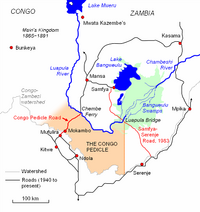
Map showing the Congo Pedicle relative to the borders formed by the Luapula River and Congo-Zambezi watershed.
163:
1830:
1254:
239:
2400:
2219:
2171:
1191:
1034:
380:
The province borders along DR Congo and it extends along the northern and eastern banks of the river from
369:
258:
1862:
1476:
1258:
243:
2700:
2501:
2410:
2046:
1992:
1199:
1714:
2715:
2380:
1494:(Report). Lusaka: Central Statistical Office, Republic of Zambia. 1970. pp. A6–7. Archived from
1175:
917:
392:
of the DR Congo, which sticks into neighbouring Zambia, divides it into two lobes. It is bordered by
326:
349:
2745:
2680:
2652:
2647:
2496:
2307:
2297:
2244:
2211:
2201:
2135:
1163:
905:
901:
385:
321:(MMD), who went on to become the President of Zambia in 1991, obtained majority mandate during the
304:
213:(DR Congo) and domestically extends along the northern and eastern banks of the Luapula river from
203:
191:
46:
2833:
2778:
2710:
2627:
2574:
2559:
2420:
2327:
2229:
1515:(Report). Lusaka: Central Statistical Office, Republic of Zambia. 2003. p. 6. Archived from
1409:
1274:
1242:
1238:
1207:
1942:
1916:
2803:
2740:
2720:
2685:
2642:
2637:
2617:
2579:
2486:
2478:
2443:
2390:
2259:
2239:
2224:
2161:
2156:
2151:
2052:
2031:
1451:
1246:
1183:
314:
1329:
2838:
2828:
2823:
2818:
2730:
2662:
2657:
2632:
2622:
2612:
2564:
2539:
2516:
2506:
2468:
2458:
2448:
2405:
2385:
2375:
2342:
2322:
2302:
2292:
2282:
2254:
2249:
2196:
1894:
1401:
1266:
1195:
1179:
1171:
932:
389:
283:
1516:
1454:. Norway: Norwegian Meteorological Institute and Norwegian Broadcasting Corporation. 2007.
2813:
2808:
2793:
2788:
2783:
2768:
2705:
2695:
2584:
2549:
2544:
2463:
2435:
2425:
2415:
2370:
2337:
2332:
2317:
2312:
2191:
2186:
2181:
1282:
1250:
1211:
1203:
1167:
421:
235:
1767:
1392:
Griffiths, Ieuan (July 1986). "The Scramble for Africa: Inherited Political Boundaries".
1253:
in Mansa, Mumbotuta Waterfalls in the confluence of Mumbotuta streams and Luapula River,
384:
to Lake Mweru, including waters and islands of those lakes. Congo Pedicle, the southeast
17:
2843:
2798:
2773:
2750:
2735:
2725:
2690:
2594:
2589:
2569:
2554:
2511:
2491:
2453:
2395:
2352:
2347:
2287:
2264:
2234:
2176:
2166:
1262:
1234:
1187:
923:
381:
307:
231:
226:
214:
2072:(Report). Lusaka: Central Statistical Office, Republic of Zambia. 2012. Archived from
2890:
1030:
695:
405:
365:
361:
341:
333:
254:
199:
195:
89:
1053:
incidences for every 1,000 people in the province as of 2005, and there were 5,209
913:
413:
344:
is located between the province and the industrial and commercial heartland of the
222:
194:
located in the northern part of the country. Luapula Province is named after the
348:. The issues in transportation was partly resolved with the construction of the
1305:
1330:"Luapula (Province, Zambia) - Population Statistics, Charts, Map and Location"
345:
337:
218:
2872:
2859:
2024:
Gould, Jeremy (2002). "Zambia:contesting Democracy". In Laakso, Liisa (ed.).
1038:
417:
409:
262:
151:
927:
1050:
357:
287:
1413:
1286:
1026:
425:
401:
353:
291:
250:
187:
156:
79:
2010:
1405:
1868:(Report). Common Wealth Local Government Forum. pp. 218–220.
1770:. Zambia Data Portal, Central statistical Office of Zambia. 2011.
1225:
400:
on the southeastern side. The major towns in the province include
1054:
799:
2101:
926:
was the most spoken language with 71.30 per cent speaking it.
360:
road, and being further alleviated by the construction of the
794:
2013:
Chilundika Fired from the Provincial Minister position
1477:
Clima Data.org - Clima Data for Mansa from 1991 to 2021
282:
In the 19th century, the valley was dominated by the
1306:"Sub-national HDI - Area Database - Global Data Lab"
2759:
2671:
2603:
2530:
2477:
2434:
2361:
2273:
2210:
2142:
162:
150:
142:
134:
129:
121:
116:
108:
100:
95:
85:
65:
37:
1245:in Kawambwa district, Kabwelume Waterfalls on the
1080:Agriculture, Forestry & Fishing (by Industry)
935:(IMR) of 100 deaths per 1,000 births as of 2010.
2067:Summary report for the 2010 Census of population
1513:Summary report for the 2000 Census of population
225:, who are also the major tribe in the country.
209:The province has an international border along
1739:. Central Statistical Office of Zambia. 2016.
2113:
1693:"AIDS and HIV statistics of Laupula Province"
8:
2087:(Report). International Monetary Fund. 2007.
1991:. Zambia Tourism Board. 2011. Archived from
1941:. Zambia Tourism Board. 2011. Archived from
1831:Zambia Public administration Country profile
1811:. Central Statistical Office of Zambia. 2008
1717:. Central Statistical Office of Zambia. 2011
1695:. Central Statistical Office of Zambia. 2011
785:
329:and rural credit schemes during the 1990s.
2120:
2106:
2098:
1064:
942:
784:
431:
34:
1791:
1789:
1452:"Weather statistics for Luapula (Zambia)"
1269:, and the Nchelemge Beach in Lake Mweru.
290:. The boundaries of the province between
2085:Zambia: Poverty Reduction Strategy Paper
2030:. James Currey Publishers. p. 314.
273:
249:The chief artery of the province is the
1762:
1760:
1758:
1737:"Agriculture statistics of Zambia 2014"
1297:
916:of the province was 7.70 per cent. The
161:
149:
128:
125:50,567 km (19,524 sq mi)
115:
94:
84:
64:
52:
1489:Census of population and housing, 1969
60:Luapula Province showing its districts
1863:The local government system in Zambia
1543:
1541:
1528:
1526:
1351:
1349:
141:
133:
120:
107:
99:
7:
1939:"National parks in Luapala province"
1875:from the original on 18 October 2016
1743:from the original on 19 October 2016
1458:from the original on 20 October 2016
1112:Financial & Insurance activities
368:, which is also the headquarters of
1843:from the original on 4 January 2017
332:The province is bordered along the
2048:Zambia: Life in an African Country
435:Climate data for Luapula (Zambia)
340:and to its north by DR Congo. The
319:Movement for Multi-Party Democracy
301:United National Independence Party
25:
2011:https://www.times.co.zm/?p=126297
364:. The capital of the province is
2129:
1989:"Ceremonies in Luapala province"
1975:
1963:
1895:"Waterfalls in Luapala province"
1774:from the original on 10 May 2017
1426:
1355:
211:Democratic Republic of the Congo
109: • Provincial Minister
72:
54:
2027:Multi-party elections in Africa
946:HIV infected & AIDS deaths
221:. The province is inhabited by
1265:, the shores of Lake Mweru in
1088:Community, Social and Personal
112:Derricky Chilundika (Formerly)
1:
2045:Mwakikagile, Godfrey (2010).
1917:"Beaches in Luapala province"
1919:. Zambia Tourism Board. 2011
1897:. Zambia Tourism Board. 2011
1152:Wholesale & Retail Trade
939:Economy and utility services
1796:International Monetary Fund
1679:
1667:
1655:
1643:
1631:
1619:
1607:
1595:
1583:
1571:
1559:
1547:
1532:
1439:International Monetary Fund
1271:Lusenga Plain National Park
1104:Electricity, Gas, and water
1047:International Monetary Fund
624:Mean daily minimum °C (°F)
554:Mean daily maximum °C (°F)
246:are the major water falls.
2918:
1379:
1367:
1144:Transportation and Storage
772:
767:
434:
1715:"AIDS and HIV statistics"
945:
882:
812:—
693:
623:
553:
483:
478:
475:
472:
469:
466:
463:
460:
457:
454:
451:
448:
445:
442:
439:
104:Provincial Administration
53:
44:
1795:
1438:
1394:The Geographical Journal
396:on the eastern side and
238:, Mumbotuta Waterfalls,
18:Luapula Province, Zambia
1074:% of working population
2605:North-Western Province
1231:
1136:Mining & Quarrying
1120:Hotels and Restaurants
428:and precious metals.
327:agricultural subsidies
279:
1809:"Labour force survey"
1334:www.citypopulation.de
1310:hdi.globaldatalab.org
1255:Kundabwika Waterfalls
1229:
1200:Mwansabombwe District
933:infant mortality rate
786:Historical population
277:
240:Kundabwika Waterfalls
146:30/km (78/sq mi)
2051:. New Africa Press.
1176:Chifunabuli District
918:total fertility rate
484:Record high °C (°F)
143: • Density
2902:Provinces of Zambia
2869: /
2212:Copperbelt Province
2136:Districts of Zambia
1259:Chilongo Waterfalls
1222:Culture and tourism
906:2000 Zambian census
902:2010 Zambian census
787:
244:Chilongo Waterfalls
204:2022 Zambian census
198:and its capital is
1995:on 20 October 2016
1945:on 20 October 2016
1275:Bangweulu Wetlands
1239:Mporokoso District
1232:
1208:Nchelenge District
311:during the 1980s.
294:and DR Congo were
280:
135: • Total
122: • Total
32:Province in Zambia
29:Province of Zambia
2873:11.000°S 29.000°E
2852:
2851:
2673:Southern Province
2532:Northern Province
2479:Muchinga Province
1247:Kalungwishi River
1243:Ntumbacushi Falls
1184:Kawambwa District
1159:
1158:
1022:
1021:
914:unemployment rate
898:
897:
777:
776:
394:Northern Province
315:Frederick Chiluba
181:
180:
101: • Type
16:(Redirected from
2909:
2897:Luapula Province
2884:
2883:
2881:
2880:
2879:
2874:
2870:
2867:
2866:
2865:
2862:
2761:Western Province
2363:Luapula Province
2275:Eastern Province
2144:Central Province
2134:
2133:
2132:
2122:
2115:
2108:
2099:
2088:
2080:
2078:
2071:
2062:
2041:
2005:
2004:
2002:
2000:
1985:
1979:
1976:Mwakikagile 2010
1973:
1967:
1964:Mwakikagile 2010
1961:
1955:
1954:
1952:
1950:
1935:
1929:
1928:
1926:
1924:
1913:
1907:
1906:
1904:
1902:
1891:
1885:
1884:
1882:
1880:
1874:
1867:
1859:
1853:
1852:
1850:
1848:
1842:
1835:
1827:
1821:
1820:
1818:
1816:
1805:
1799:
1793:
1784:
1783:
1781:
1779:
1764:
1753:
1752:
1750:
1748:
1733:
1727:
1726:
1724:
1722:
1711:
1705:
1704:
1702:
1700:
1689:
1683:
1677:
1671:
1665:
1659:
1653:
1647:
1641:
1635:
1629:
1623:
1617:
1611:
1605:
1599:
1593:
1587:
1581:
1575:
1569:
1563:
1557:
1551:
1545:
1536:
1530:
1521:
1520:
1509:
1503:
1502:
1500:
1493:
1485:
1479:
1474:
1468:
1467:
1465:
1463:
1448:
1442:
1436:
1430:
1427:Mwakikagile 2010
1424:
1418:
1417:
1389:
1383:
1377:
1371:
1365:
1359:
1356:Mwakikagile 2010
1353:
1344:
1343:
1341:
1340:
1326:
1320:
1319:
1317:
1316:
1302:
1267:Chienge District
1196:Milenge District
1180:Chipili District
1172:Chiengi District
1065:
943:
908:stood at 19.60.
801:
796:
788:
432:
398:Central Province
390:Katanga Province
317:, the leader of
284:Kingdom of Lunda
184:Luapula Province
173:
78:
76:
75:
58:
35:
21:
2917:
2916:
2912:
2911:
2910:
2908:
2907:
2906:
2887:
2886:
2878:-11.000; 29.000
2877:
2875:
2871:
2868:
2863:
2860:
2858:
2856:
2855:
2853:
2848:
2755:
2667:
2599:
2526:
2473:
2436:Lusaka Province
2430:
2357:
2269:
2206:
2138:
2130:
2128:
2126:
2096:
2091:
2083:
2076:
2069:
2065:
2059:
2044:
2038:
2023:
2019:
2008:
1998:
1996:
1987:
1986:
1982:
1974:
1970:
1962:
1958:
1948:
1946:
1937:
1936:
1932:
1922:
1920:
1915:
1914:
1910:
1900:
1898:
1893:
1892:
1888:
1878:
1876:
1872:
1865:
1861:
1860:
1856:
1846:
1844:
1840:
1833:
1829:
1828:
1824:
1814:
1812:
1807:
1806:
1802:
1794:
1787:
1777:
1775:
1766:
1765:
1756:
1746:
1744:
1735:
1734:
1730:
1720:
1718:
1713:
1712:
1708:
1698:
1696:
1691:
1690:
1686:
1678:
1674:
1666:
1662:
1654:
1650:
1642:
1638:
1630:
1626:
1618:
1614:
1606:
1602:
1594:
1590:
1582:
1578:
1570:
1566:
1558:
1554:
1546:
1539:
1531:
1524:
1511:
1510:
1506:
1498:
1491:
1487:
1486:
1482:
1475:
1471:
1461:
1459:
1450:
1449:
1445:
1437:
1433:
1425:
1421:
1391:
1390:
1386:
1378:
1374:
1366:
1362:
1354:
1347:
1338:
1336:
1328:
1327:
1323:
1314:
1312:
1304:
1303:
1299:
1295:
1251:Mumbuluma Falls
1224:
1212:Samfya District
1204:Mwense District
1168:Chembe District
1063:
941:
783:
778:
762:
757:
752:
747:
742:
737:
732:
727:
722:
717:
712:
707:
702:
688:
683:
678:
673:
668:
663:
658:
653:
648:
643:
638:
633:
628:
618:
613:
608:
603:
598:
593:
588:
583:
578:
573:
568:
563:
558:
548:
543:
538:
533:
528:
523:
518:
513:
508:
503:
498:
493:
488:
378:
272:
236:Mumbuluma Falls
171:
170:
73:
71:
61:
49:
40:
33:
30:
23:
22:
15:
12:
11:
5:
2915:
2913:
2905:
2904:
2899:
2889:
2888:
2850:
2849:
2847:
2846:
2841:
2836:
2831:
2826:
2821:
2816:
2811:
2806:
2801:
2796:
2791:
2786:
2781:
2776:
2771:
2765:
2763:
2757:
2756:
2754:
2753:
2748:
2743:
2738:
2733:
2728:
2723:
2718:
2713:
2708:
2703:
2698:
2693:
2688:
2683:
2677:
2675:
2669:
2668:
2666:
2665:
2660:
2655:
2650:
2645:
2640:
2635:
2630:
2625:
2620:
2615:
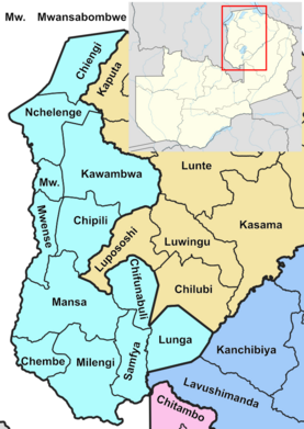
2609:
2607:
2601:
2600:
2598:
2597:
2592:
2587:
2582:
2577:
2572:
2567:
2562:
2557:
2552:
2547:
2542:
2536:
2534:
2528:
2527:
2525:
2524:
2519:
2514:
2509:
2504:
2499:
2494:
2489:
2483:
2481:
2475:
2474:
2472:
2471:
2466:
2461:
2456:
2451:
2446:
2440:
2438:
2432:
2431:
2429:
2428:
2423:
2418:
2413:
2408:
2403:
2398:
2393:
2388:
2383:
2378:
2373:
2367:
2365:
2359:
2358:
2356:
2355:
2350:
2345:
2340:
2335:
2330:
2325:
2320:
2315:
2310:
2305:
2300:
2295:
2290:
2285:
2279:
2277:
2271:
2270:
2268:
2267:
2262:
2257:
2252:
2247:
2242:
2237:
2232:
2227:
2222:
2216:
2214:
2208:
2207:
2205:
2204:
2199:
2194:
2189:
2184:
2179:
2174:
2169:
2164:
2159:
2154:
2148:
2146:
2140:
2139:
2127:
2125:
2124:
2117:
2110:
2102:
2095:
2094:External links
2092:
2090:
2089:
2081:
2079:on 2015-10-26.
2063:
2057:
2042:
2036:
2020:
2018:
2015:
2007:
2006:
1980:
1968:
1956:
1930:
1908:
1886:
1854:
1822:
1800:
1785:
1754:
1728:
1706:
1684:
1672:
1660:
1648:
1636:
1624:
1612:
1600:
1588:
1576:
1564:
1552:
1537:
1522:
1519:on 2016-10-14.
1504:
1501:on 2015-10-26.
1480:
1469:
1443:
1431:
1419:
1406:10.2307/634762
1400:(2): 204–216.
1384:
1372:
1360:
1345:
1321:
1296:
1294:
1291:
1263:Lake Bangweulu
1235:Lumangwe Falls
1230:Lumangwe falls
1223:
1220:
1192:Mansa District
1188:Lunga District
1157:
1156:
1153:
1149:
1148:
1145:
1141:
1140:
1137:
1133:
1132:
1129:
1125:
1124:
1121:
1117:
1116:
1113:
1109:
1108:
1105:
1101:
1100:
1097:
1093:
1092:
1089:
1085:
1084:
1081:
1077:
1076:
1071:
1062:
1061:Administration
1059:
1020:
1019:
1016:
1013:
1009:
1008:
1005:
1002:
998:
997:
994:
991:
987:
986:
983:
980:
976:
975:
972:
969:
965:
964:
959:
954:
948:
947:
940:
937:
912:per cent. The
896:
895:
894:
893:
890:
887:
880:
879:
876:
873:
869:
868:
865:
862:
858:
857:
854:
851:
847:
846:
843:
840:
836:
835:
832:
829:
825:
824:
821:
818:
814:
813:
810:
807:
803:
802:
797:
792:
782:
779:
775:
774:
770:
769:
765:
764:
759:
754:
749:
744:
739:
734:
729:
724:
719:
714:
709:
704:
699:
691:
690:
685:
680:
675:
670:
665:
660:
655:
650:
645:
640:
635:
630:
625:
621:
620:
615:
610:
605:
600:
595:
590:
585:
580:
575:
570:
565:
560:
555:
551:
550:
545:
540:
535:
530:
525:
520:
515:
510:
505:
500:
495:
490:
485:
481:
480:
477:
474:
471:
468:
465:
462:
459:
456:
453:
450:
447:
444:
441:
437:
436:
430:
382:Lake Bangweulu
377:
374:
370:Mansa district
350:Luapula Bridge
323:1991 elections
308:Kenneth Kaunda
271:
268:
232:Lumangwe Falls
215:Lake Bangweulu
179:
178:
167:
160:
159:
154:
148:
147:
144:
140:
139:
136:
132:
131:
127:
126:
123:
119:
118:
114:
113:
110:
106:
105:
102:
98:
97:
93:
92:
87:
83:
82:
69:
63:
62:
59:
51:
50:
45:
42:
41:
38:
31:
28:
24:
14:
13:
10:
9:
6:
4:
3:
2:
2914:
2903:
2900:
2898:
2895:
2894:
2892:
2885:
2882:
2845:
2842:
2840:
2837:
2835:
2832:
2830:
2827:
2825:
2822:
2820:
2817:
2815:
2812:
2810:
2807:
2805:
2802:
2800:
2797:
2795:
2792:
2790:
2787:
2785:
2782:
2780:
2777:
2775:
2772:
2770:
2767:
2766:
2764:
2762:
2758:
2752:
2749:
2747:
2744:
2742:
2739:
2737:
2734:
2732:
2729:
2727:
2724:
2722:
2719:
2717:
2714:
2712:
2709:
2707:
2704:
2702:
2699:
2697:
2694:
2692:
2689:
2687:
2684:
2682:
2679:
2678:
2676:
2674:
2670:
2664:
2661:
2659:
2656:
2654:
2651:
2649:
2646:
2644:
2641:
2639:
2636:
2634:
2631:
2629:
2626:
2624:
2621:
2619:
2616:
2614:
2611:
2610:
2608:
2606:
2602:
2596:
2593:
2591:
2588:
2586:
2583:
2581:
2578:
2576:
2573:
2571:
2568:
2566:
2563:
2561:
2558:
2556:
2553:
2551:
2548:
2546:
2543:
2541:
2538:
2537:
2535:
2533:
2529:
2523:
2522:Shiwa Ng'andu
2520:
2518:
2515:
2513:
2510:
2508:
2505:
2503:
2500:
2498:
2495:
2493:
2490:
2488:
2485:
2484:
2482:
2480:
2476:
2470:
2467:
2465:
2462:
2460:
2457:
2455:
2452:
2450:
2447:
2445:
2442:
2441:
2439:
2437:
2433:
2427:
2424:
2422:
2419:
2417:
2414:
2412:
2409:
2407:
2404:
2402:
2399:
2397:
2394:
2392:
2389:
2387:
2384:
2382:
2379:
2377:
2374:
2372:
2369:
2368:
2366:
2364:
2360:
2354:
2351:
2349:
2346:
2344:
2341:
2339:
2336:
2334:
2331:
2329:
2326:
2324:
2321:
2319:
2316:
2314:
2311:
2309:
2306:
2304:
2301:
2299:
2296:
2294:
2291:
2289:
2286:
2284:
2281:
2280:
2278:
2276:
2272:
2266:
2263:
2261:
2258:
2256:
2253:
2251:
2248:
2246:
2243:
2241:
2238:
2236:
2233:
2231:
2228:
2226:
2223:
2221:
2220:Chililabombwe
2218:
2217:
2215:
2213:
2209:
2203:
2200:
2198:
2195:
2193:
2190:
2188:
2185:
2183:
2180:
2178:
2175:
2173:
2172:Kapiri Mposhi
2170:
2168:
2165:
2163:
2160:
2158:
2155:
2153:
2150:
2149:
2147:
2145:
2141:
2137:
2123:
2118:
2116:
2111:
2109:
2104:
2103:
2100:
2093:
2086:
2082:
2075:
2068:
2064:
2060:
2058:9789987160112
2054:
2050:
2049:
2043:
2039:
2037:9780852558430
2033:
2029:
2028:
2022:
2021:
2016:
2014:
2012:
1994:
1990:
1984:
1981:
1977:
1972:
1969:
1965:
1960:
1957:
1944:
1940:
1934:
1931:
1918:
1912:
1909:
1896:
1890:
1887:
1871:
1864:
1858:
1855:
1839:
1832:
1826:
1823:
1810:
1804:
1801:
1797:
1792:
1790:
1786:
1773:
1769:
1763:
1761:
1759:
1755:
1742:
1738:
1732:
1729:
1716:
1710:
1707:
1694:
1688:
1685:
1681:
1676:
1673:
1669:
1664:
1661:
1657:
1652:
1649:
1645:
1640:
1637:
1633:
1628:
1625:
1621:
1616:
1613:
1609:
1604:
1601:
1597:
1592:
1589:
1585:
1580:
1577:
1573:
1568:
1565:
1561:
1556:
1553:
1549:
1544:
1542:
1538:
1534:
1529:
1527:
1523:
1518:
1514:
1508:
1505:
1497:
1490:
1484:
1481:
1478:
1473:
1470:
1457:
1453:
1447:
1444:
1440:
1435:
1432:
1428:
1423:
1420:
1415:
1411:
1407:
1403:
1399:
1395:
1388:
1385:
1381:
1376:
1373:
1369:
1364:
1361:
1357:
1352:
1350:
1346:
1335:
1331:
1325:
1322:
1311:
1307:
1301:
1298:
1292:
1290:
1288:
1284:
1278:
1276:
1272:
1268:
1264:
1260:
1256:
1252:
1248:
1244:
1240:
1236:
1228:
1221:
1219:
1215:
1213:
1209:
1205:
1201:
1197:
1193:
1189:
1185:
1181:
1177:
1173:
1169:
1165:
1154:
1151:
1150:
1146:
1143:
1142:
1138:
1135:
1134:
1130:
1128:Manufacturing
1127:
1126:
1122:
1119:
1118:
1114:
1111:
1110:
1106:
1103:
1102:
1098:
1095:
1094:
1090:
1087:
1086:
1082:
1079:
1078:
1075:
1072:
1070:
1067:
1066:
1060:
1058:
1056:
1052:
1048:
1043:
1040:
1036:
1032:
1028:
1017:
1014:
1011:
1010:
1006:
1003:
1000:
999:
995:
992:
989:
988:
984:
981:
978:
977:
973:
970:
967:
966:
963:
960:
958:
955:
953:
950:
949:
944:
938:
936:
934:
929:
925:
921:
919:
915:
909:
907:
903:
891:
888:
885:
884:
881:
877:
874:
871:
870:
866:
863:
860:
859:
855:
852:
849:
848:
844:
841:
838:
837:
833:
830:
827:
826:
822:
819:
816:
815:
811:
808:
805:
804:
798:
793:
790:
789:
780:
771:
766:
760:
755:
750:
745:
740:
735:
730:
725:
720:
715:
710:
705:
700:
697:
696:precipitation
692:
686:
681:
676:
671:
666:
661:
656:
651:
646:
641:
636:
631:
626:
622:
616:
611:
606:
601:
596:
591:
586:
581:
576:
571:
566:
561:
556:
552:
546:
541:
536:
531:
526:
521:
516:
511:
506:
501:
496:
491:
486:
482:
438:
433:
429:
427:
423:
419:
415:
411:
407:
403:
399:
395:
391:
387:
383:
375:
373:
371:
367:
363:
362:Chembe Bridge
359:
355:
351:
347:
343:
342:Congo Pedicle
339:
335:
334:Luapula River
330:
328:
324:
320:
316:
312:
309:
306:
302:
297:
293:
289:
285:
276:
269:
267:
264:
260:
256:
252:
247:
245:
241:
237:
233:
228:
224:
220:
216:
212:
207:
205:
202:. As per the
201:
197:
196:Luapula River
193:
189:
185:
177:
168:
165:
158:
155:
153:
145:
137:
124:
111:
103:
91:
88:
81:
70:
68:
57:
48:
43:
36:
27:
19:
2854:
2701:Itezhi-Tezhi
2502:Lavushimanda
2411:Mwansabombwe
2362:
2074:the original
2047:
2026:
2009:
1997:. Retrieved
1993:the original
1983:
1971:
1959:
1947:. Retrieved
1943:the original
1933:
1921:. Retrieved
1911:
1899:. Retrieved
1889:
1877:. Retrieved
1857:
1845:. Retrieved
1825:
1813:. Retrieved
1803:
1798:2007, p. 336
1776:. Retrieved
1768:"Atlas Home"
1745:. Retrieved
1731:
1719:. Retrieved
1709:
1697:. Retrieved
1687:
1675:
1663:
1651:
1639:
1627:
1615:
1603:
1591:
1579:
1567:
1555:
1517:the original
1507:
1496:the original
1483:
1472:
1460:. Retrieved
1446:
1441:2007, p. 335
1434:
1422:
1397:
1393:
1387:
1375:
1363:
1337:. Retrieved
1333:
1324:
1313:. Retrieved
1309:
1300:
1279:
1233:
1216:
1160:
1096:Construction
1073:
1068:
1044:
1035:Mwansabombwe
1023:
961:
957:HIV infected
956:
951:
922:
910:
899:
781:Demographics
698:mm (inches)
414:Mwansabombwe
379:
331:
313:
281:
259:Mwansabombwe
248:
208:
183:
182:
26:
2876: /
2716:Livingstone
2381:Chifunabuli
1680:Census 2012
1668:Census 2012
1656:Census 2012
1644:Census 2012
1632:Census 2012
1620:Census 2012
1608:Census 2012
1596:Census 2012
1584:Census 2012
1574:, pp. 12–13
1572:Census 2012
1560:Census 2012
1548:Census 2012
1533:Census 2012
1237:located in
962:AIDS deaths
900:As per the
773:Source 2:
768:Source 1:
2891:Categories
2746:Sinazongwe
2681:Chikankata
2653:Mwinilunga
2648:Mushindano
2497:Kanchibiya
2308:Kasenengwa
2298:Chipangali
2245:Lufwanyama
2202:Shibuyunji
2017:References
1999:19 October
1966:, p. 68–69
1949:19 October
1923:19 October
1901:19 October
1879:16 October
1847:16 October
1778:16 October
1747:17 October
1462:20 October
1380:Gould 2002
1368:Gould 2002
1339:2024-01-28
1315:2018-09-13
1283:Luba Lunda
1069:Profession
889:1980–2000:
346:Copperbelt
338:Lake Mweru
336:, through
219:Lake Mweru
186:is one of
130:Population
96:Government
2834:Shangombo
2779:Limulunga
2711:Kazungula
2628:Kalumbila
2575:Mporokoso
2560:Lupososhi
2421:Nchelenge
2328:Lusangazi
2230:Kalulushi
1166:, namely
1164:districts
1039:Nchelenge
883:Sources:
875:1,519,478
418:manganese
410:Nchelenge
376:Geography
305:President
286:of Mwata
263:Nchelenge
192:provinces
152:Time zone
138:1,519,478
2804:Mulobezi
2741:Siavonga
2721:Mazabuka
2686:Chirundu
2643:Mufumbwe
2638:Manyinga
2618:Ikelenge
2580:Mpulungu
2487:Chinsali
2444:Chilanga
2391:Kawambwa
2260:Mufulira
2240:Luanshya
2225:Chingola
2162:Chitambo
2157:Chisamba
2152:Chibombo
1870:Archived
1838:Archived
1815:9 August
1772:Archived
1741:Archived
1721:9 August
1699:9 August
1456:Archived
1382:, p. 314
1370:, p. 321
928:Albinism
886:1964–69:
694:Average
352:and the
299:for the
296:disputed
47:Province
2864:29°00′E
2861:11°00′S
2839:Sikongo
2829:Sesheke
2824:Senanga
2819:Nkeyema
2731:Namwala
2663:Zambezi
2658:Solwezi
2633:Kasempa
2623:Kabompo
2613:Chavuma
2565:Luwingu
2540:Chilubi
2517:Nakonde
2507:Mafinga
2469:Rufunsa
2459:Luangwa
2449:Chongwe
2406:Milenge
2386:Chipili
2376:Chiengi
2343:Petauke
2323:Lundazi
2303:Chipata
2293:Chasefu
2283:Chadiza
2255:Mpongwe
2250:Masaiti
2197:Serenje
1978:, p. 83
1682:, p. 49
1670:, p. 41
1658:, p. 74
1646:, p. 78
1634:, p. 99
1622:, p. 93
1610:, p. 44
1598:, p. 21
1586:, p. 19
1562:, p. 17
1550:, p. 24
1429:, p. 70
1358:, p. 68
1051:Malaria
864:991,927
853:775,353
842:750,542
834:+116.9%
831:728,775
820:336,000
809:357,000
763:(43.1)
703:(10.1)
689:(47.5)
684:(62.2)
679:(62.4)
674:(61.0)
669:(56.3)
664:(50.7)
659:(47.5)
654:(48.4)
649:(54.1)
644:(59.7)
639:(61.9)
634:(62.2)
629:(62.2)
619:(73.8)
614:(69.4)
609:(72.0)
604:(73.8)
599:(71.2)
594:(65.5)
589:(61.9)
584:(61.7)
579:(65.8)
574:(69.1)
569:(69.6)
564:(69.6)
559:(69.4)
549:(88.2)
544:(80.8)
539:(84.6)
534:(88.2)
529:(86.7)
524:(81.1)
519:(77.4)
514:(77.4)
509:(80.1)
504:(81.1)
499:(81.3)
494:(81.1)
489:(80.8)
388:of the
386:salient
358:Serenje
288:Kazembe
270:History
190:'s ten
86:Capital
67:Country
39:Luapula
2814:Nalolo
2809:Mwandi
2794:Mitete
2789:Lukulu
2784:Luampa
2769:Kalabo
2706:Kalomo
2696:Gwembe
2585:Mungwi
2550:Kasama
2545:Kaputa
2464:Lusaka
2426:Samfya
2416:Mwense
2371:Chembe
2338:Nyimba
2333:Mambwe
2318:Lumezi
2313:Katete
2192:Ngabwe
2187:Mumbwa
2182:Mkushi
2055:
2034:
1535:, p. 7
1414:634762
1412:
1287:Samfya
1083:10.50
1027:Samfya
1018:5,209
1015:51,211
1007:5,131
1004:49,798
996:3,682
993:46,293
985:1,478
982:32,447
878:+53.2%
867:+27.9%
758:(9.7)
753:(5.1)
748:(0.7)
743:(0.0)
723:(0.1)
718:(1.8)
713:(6.9)
708:(8.6)
440:Month
426:copper
402:Samfya
354:Samfya
292:Zambia
251:Samfya
188:Zambia
166:(2018)
80:Zambia
77:
2844:Sioma
2799:Mongu
2774:Kaoma
2751:Zimba
2736:Pemba
2726:Monze
2691:Choma
2595:Senga
2590:Nsama
2570:Mbala
2555:Lunte
2512:Mpika
2492:Isoka
2454:Kafue
2401:Mansa
2396:Lunga
2353:Vubwi
2348:Sinda
2288:Chama
2265:Ndola
2235:Kitwe
2177:Luano
2167:Kabwe
2077:(PDF)
2070:(PDF)
1873:(PDF)
1866:(PDF)
1841:(PDF)
1834:(PDF)
1499:(PDF)
1492:(PDF)
1410:JSTOR
1293:Notes
1155:4.80
1147:3.20
1139:0.90
1131:4.30
1123:1.40
1115:2.40
1107:0.00
1099:3.10
1091:3.10
1031:Mansa
971:6,971
924:Bemba
892:2010:
856:+3.3%
845:+3.0%
823:−5.9%
761:1,095
479:Year
406:Mansa
366:Mansa
255:Mansa
227:Bemba
223:Lunda
200:Mansa
169:0.520
157:UTC+2
90:Mansa
2053:ISBN
2032:ISBN
2001:2016
1951:2016
1925:2016
1903:2016
1881:2016
1849:2016
1817:2017
1780:2016
1749:2016
1723:2017
1701:2017
1464:2016
1273:and
1210:and
1055:AIDS
1012:2010
1001:2005
990:2000
979:1995
974:198
968:1990
952:Year
872:2022
861:2010
850:2000
839:1990
828:1980
817:1969
806:1964
795:Pop.
791:Year
738:(0)
733:(0)
728:(0)
682:16.8
677:16.9
672:16.1
667:13.5
662:10.4
647:12.3
642:15.4
637:16.6
632:16.8
627:16.8
617:23.2
612:20.8
607:22.2
602:23.2
597:21.8
592:18.6
587:16.6
582:16.5
577:18.8
572:20.6
567:20.9
562:20.9
557:20.8
547:31.2
542:27.1
537:29.2
532:31.2
527:30.4
522:27.3
517:25.2
512:25.2
507:26.7
502:27.3
497:27.4
492:27.3
487:27.1
476:Dec
473:Nov
470:Oct
467:Sep
464:Aug
461:Jul
458:Jun
455:May
452:Apr
449:Mar
446:Feb
443:Jan
422:lime
412:and
242:and
117:Area
1402:doi
1398:152
756:246
751:129
711:176
706:219
701:256
687:8.6
657:8.6
652:9.1
217:to
176:8th
172:low
164:HDI
2893::
1788:^
1757:^
1540:^
1525:^
1408:.
1396:.
1348:^
1332:.
1308:.
1257:,
1249:,
1241:,
1206:,
1202:,
1198:,
1194:,
1190:,
1186:,
1182:,
1178:,
1174:,
1170:,
800:±%
746:19
716:46
424:,
420:,
408:,
404:,
372:.
234:,
174:·
2121:e
2114:t
2107:v
2061:.
2040:.
2003:.
1953:.
1927:.
1905:.
1883:.
1851:.
1819:.
1782:.
1751:.
1725:.
1703:.
1466:.
1416:.
1404::
1342:.
1318:.
1037:-
1033:-
1029:-
741:1
736:0
731:0
726:0
721:3
356:-
261:-
257:-
253:-
20:)
Text is available under the Creative Commons Attribution-ShareAlike License. Additional terms may apply.