902:
45:
73:
103:
1095:
110:
80:
471:
34.1% of the population was under the age of 18, 2.4% from 18 to 24, 22.0% from 25 to 44, 19.5% from 45 to 64, and 22.0% who were 65 years of age or older. The median age was 36.8 years. For every 100 females, there were 70.8 males. For every 100 females ages 18 and older, there were 80.0 males.
467:
Of the 15 households, 20.0% had children under the age of 18; 46.7% were married couples living together; 6.7% had a female householder with no spouse or partner present. 40.0% of households consisted of individuals and 20.0% had someone living alone who was 65 years of age or older. The average
407:
counted 41 people, 15 households, and 9 families in Ludell. The population density was 108.8 per square mile (42.0/km). There were 31 housing units at an average density of 82.2 per square mile (31.7/km). The racial makeup was 92.68% (38)
1155:
1136:
57:
346:
67744. The first post office in Ludell was established in 1876. From the years 1876 until 1881, the post office was called either Danube, Kelso, or Prag for some time.
830:
1165:
524:
282:
135:
1160:
1129:
823:
577:
515:
292:
49:
44:
544:
102:
1122:
758:
1170:
816:
520:
441:
421:
798:
733:
708:
72:
808:
429:
270:
449:
637:
191:
663:
565:
404:
380:
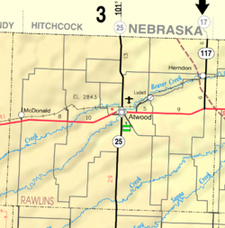
323:
167:
510:
913:
307:
35:
1102:
840:
802:
786:
603:
481:
457:
311:
196:
53:
1065:
453:
1072:
461:
243:
931:
437:
409:
994:
417:
395:
989:
974:
969:
964:
682:
413:
233:
1106:
581:
959:
941:
891:
540:
425:
1004:
984:
886:
694:
445:
638:"US Census Bureau, Table DP1: PROFILE OF GENERAL POPULATION AND HOUSING CHARACTERISTICS"
1019:
1009:
999:
881:
862:
327:
1149:
979:
433:
319:
275:
172:
734:"US Census Bureau, Table P2: HISPANIC OR LATINO, AND NOT HISPANIC OR LATINO BY RACE"
1094:
855:
339:
951:
179:
150:
137:
224:
343:
258:
326:, the population was 41. It is 5.5 miles (8.9 km) northeast of
315:
184:
250:
229:
901:
873:
812:
900:
468:
household size was 2.1 and the average family size was 2.1.
759:"US Census Bureau, Table S1101: HOUSEHOLDS AND FAMILIES"
1110:
535:
533:
1018:
950:
930:
912:
872:
291:
281:
269:
257:
240:
223:
215:
210:
202:
190:
178:
166:
26:
1156:Census-designated places in Rawlins County, Kansas
16:Unincorporated community in Rawlins County, Kansas
1130:
824:
604:"US Census Bureau, Table P16: HOUSEHOLD TYPE"
464:of any race was 2.44% (1) of the population.
8:
580:. Kansas Historical Society. Archived from
1137:
1123:
831:
817:
809:
787:List of books about Rawlins County, Kansas
353:
23:
905:Map of Kansas highlighting Rawlins County
541:"Profile of Ludell, Kansas (CDP) in 2020"
525:United States Department of the Interior
493:
280:
256:
222:
209:
201:
165:
130:
64:
690:
680:
505:
503:
501:
499:
497:
373:
547:from the original on December 1, 2021
290:
268:
239:
214:
189:
177:
41:
7:
1166:Populated places established in 1876
1091:
1089:
632:
630:
628:
626:
624:
516:Geographic Names Information System
1109:. You can help Knowledge (XXG) by
839:Municipalities and communities of
709:"US Census Bureau, Table P1: RACE"
363:
14:
1101:This article about a location in
1093:
578:"Kansas Post Offices, 1828-1961"
108:
101:
78:
71:
43:
543:. United States Census Bureau.
521:United States Geological Survey
109:
79:
1:
1161:1876 establishments in Kansas
122:Show map of the United States
21:CDP in Kansas, United States
480:The community is served by
1187:
1088:
784:
206:2,782 ft (848 m)
1061:
898:
853:
405:2020 United States census
394:
379:
372:
367:
362:
359:
131:
65:
42:
33:
484:public school district.
308:census-designated place
1171:Kansas geography stubs
1103:Rawlins County, Kansas
906:
842:Rawlins County, Kansas
482:Rawlins County USD 105
151:39.85556°N 100.96000°W
904:
797:Rawlins County maps:
452:, and 4.88% (2) from
396:U.S. Decennial Census
355:Historical population
242: • Summer (
1074:United States portal
156:39.85556; -100.96000
662:Bureau, US Census.
356:
147: /
907:
693:has generic name (
584:on October 9, 2013
418:non-Hispanic white
354:
216: • Total
92:Show map of Kansas
1118:
1117:
1083:
1082:
664:"Gazetteer Files"
454:two or more races
448:, 2.44% (1) from
414:European American
401:
400:
301:
300:
1178:
1139:
1132:
1125:
1097:
1090:
1075:
1068:
903:
865:
858:
848:
843:
833:
826:
819:
810:
774:
773:
771:
769:
755:
749:
748:
746:
744:
730:
724:
723:
721:
719:
705:
699:
698:
692:
688:
686:
678:
676:
674:
659:
653:
652:
650:
648:
634:
619:
618:
616:
614:
600:
594:
593:
591:
589:
574:
568:
563:
557:
556:
554:
552:
537:
528:
527:
511:"Ludell, Kansas"
507:
442:Pacific Islander
426:African-American
375:
370:
365:
357:
247:
162:
161:
159:
158:
157:
152:
148:
145:
144:
143:
140:
123:
112:
111:
105:
93:
82:
81:
75:
47:
24:
1186:
1185:
1181:
1180:
1179:
1177:
1176:
1175:
1146:
1145:
1144:
1143:
1086:
1084:
1079:
1073:
1066:
1057:
1014:
946:
933:
926:
908:
896:
868:
863:
856:
849:
846:
841:
837:
794:
789:
783:
781:Further reading
778:
777:
767:
765:
763:data.census.gov
757:
756:
752:
742:
740:
738:data.census.gov
732:
731:
727:
717:
715:
713:data.census.gov
707:
706:
702:
689:
679:
672:
670:
661:
660:
656:
646:
644:
642:data.census.gov
636:
635:
622:
612:
610:
608:data.census.gov
602:
601:
597:
587:
585:
576:
575:
571:
566:ZIP Code Lookup
564:
560:
550:
548:
539:
538:
531:
509:
508:
495:
490:
478:
446:Native Hawaiian
430:Native American
368:
352:
336:
265:
241:
155:
153:
149:
146:
141:
138:
136:
134:
133:
127:
126:
125:
124:
121:
120:
119:
118:
117:
113:
96:
95:
94:
91:
90:
89:
88:
87:
83:
61:
38:
29:
22:
17:
12:
11:
5:
1184:
1182:
1174:
1173:
1168:
1163:
1158:
1148:
1147:
1142:
1141:
1134:
1127:
1119:
1116:
1115:
1098:
1081:
1080:
1078:
1077:
1070:
1062:
1059:
1058:
1056:
1055:
1052:
1049:
1046:
1043:
1040:
1037:
1034:
1031:
1028:
1024:
1022:
1016:
1015:
1013:
1012:
1007:
1002:
997:
992:
987:
982:
977:
972:
967:
962:
956:
954:
948:
947:
945:
944:
938:
936:
932:Unincorporated
928:
927:
925:
924:
918:
916:
910:
909:
899:
897:
895:
894:
889:
884:
878:
876:
870:
869:
854:
851:
850:
838:
836:
835:
828:
821:
813:
807:
806:
793:
792:External links
790:
782:
779:
776:
775:
750:
725:
700:
654:
620:
595:
569:
558:
529:
492:
491:
489:
486:
477:
474:
399:
398:
392:
391:
388:
386:
383:
377:
376:
371:
366:
361:
351:
348:
335:
332:
312:Rawlins County
299:
298:
295:
289:
288:
285:
279:
278:
273:
267:
266:
263:
261:
255:
254:
248:
238:
237:
227:
221:
220:
217:
213:
212:
208:
207:
204:
200:
199:
194:
188:
187:
182:
176:
175:
170:
164:
163:
129:
128:
115:
114:
107:
106:
100:
99:
98:
97:
85:
84:
77:
76:
70:
69:
68:
67:
66:
63:
62:
54:Rawlins County
48:
40:
39:
34:
31:
30:
28:Ludell, Kansas
27:
20:
15:
13:
10:
9:
6:
4:
3:
2:
1183:
1172:
1169:
1167:
1164:
1162:
1159:
1157:
1154:
1153:
1151:
1140:
1135:
1133:
1128:
1126:
1121:
1120:
1114:
1112:
1108:
1104:
1099:
1096:
1092:
1087:
1076:
1071:
1069:
1067:Kansas portal
1064:
1063:
1060:
1053:
1050:
1047:
1044:
1041:
1038:
1035:
1032:
1029:
1026:
1025:
1023:
1021:
1017:
1011:
1008:
1006:
1003:
1001:
998:
996:
993:
991:
988:
986:
983:
981:
978:
976:
973:
971:
968:
966:
963:
961:
958:
957:
955:
953:
949:
943:
940:
939:
937:
935:
929:
923:
920:
919:
917:
915:
911:
893:
890:
888:
885:
883:
880:
879:
877:
875:
871:
867:
866:
859:
852:
847:United States
844:
834:
829:
827:
822:
820:
815:
814:
811:
804:
800:
796:
795:
791:
788:
780:
764:
760:
754:
751:
739:
735:
729:
726:
714:
710:
704:
701:
696:
684:
669:
665:
658:
655:
643:
639:
633:
631:
629:
627:
625:
621:
609:
605:
599:
596:
583:
579:
573:
570:
567:
562:
559:
546:
542:
536:
534:
530:
526:
522:
518:
517:
512:
506:
504:
502:
500:
498:
494:
487:
485:
483:
475:
473:
469:
465:
463:
459:
455:
451:
447:
443:
439:
435:
434:Alaska Native
431:
427:
423:
419:
415:
411:
406:
397:
393:
389:
387:
384:
382:
378:
358:
349:
347:
345:
341:
338:Ludell has a
333:
331:
329:
325:
322:. As of the
321:
320:United States
317:
313:
309:
305:
296:
294:
286:
284:
277:
274:
272:
262:
260:
252:
249:
245:
235:
231:
228:
226:
218:
205:
198:
195:
193:
186:
183:
181:
174:
173:United States
171:
169:
160:
132:Coordinates:
104:
74:
59:
55:
51:
46:
37:
32:
25:
19:
1111:expanding it
1100:
1085:
921:
861:
766:. Retrieved
762:
753:
741:. Retrieved
737:
728:
716:. Retrieved
712:
703:
673:December 30,
671:. Retrieved
667:
657:
645:. Retrieved
641:
611:. Retrieved
607:
598:
586:. Retrieved
582:the original
572:
561:
551:November 30,
549:. Retrieved
514:
479:
470:
466:
420:), 0.0% (0)
402:
350:Demographics
337:
303:
302:
18:
952:Ghost towns
857:County seat
768:January 16,
743:January 16,
718:January 16,
691:|last=
647:January 16,
613:January 16,
450:other races
440:, 0.0% (0)
436:, 0.0% (0)
428:, 0.0% (0)
340:post office
324:2020 census
154: /
142:100°57′36″W
1150:Categories
995:Greshamton
785:See also:
668:Census.gov
488:References
211:Population
139:39°51′20″N
1042:Jefferson
1036:Driftwood
1020:Townships
990:Gladstone
975:Burntwood
970:Beaverton
965:Beardsley
934:community
476:Education
310:(CDP) in
283:FIPS code
271:Area code
225:Time zone
203:Elevation
1051:Rocewood
1027:Achilles
960:Achilles
942:Blakeman
892:McDonald
803:Historic
683:cite web
588:June 22,
545:Archived
458:Hispanic
416:(92.68%
344:ZIP code
287:20-43175
259:ZIP code
1005:Rawlins
985:Chardon
887:Herndon
799:Current
334:History
293:GNIS ID
197:Rawlins
168:Country
52:map of
1048:Mirage
1045:Ludell
1033:Center
1030:Atwood
1010:Rotate
1000:Mirage
922:Ludell
882:Atwood
874:Cities
864:Atwood
805:, KDOT
462:Latino
360:Census
328:Atwood
316:Kansas
304:Ludell
297:470997
192:County
185:Kansas
116:Ludell
86:Ludell
58:legend
1105:is a
1054:Union
980:Celia
438:Asian
422:black
410:white
342:with
306:is a
264:67744
253:(CDT)
251:UTC-5
230:UTC-6
180:State
1107:stub
1039:Herl
770:2024
745:2024
720:2024
695:help
675:2023
649:2024
615:2024
590:2014
553:2021
403:The
381:2020
369:Note
364:Pop.
50:KDOT
914:CDP
460:or
444:or
432:or
424:or
412:or
276:785
244:DST
234:CST
36:CDP
1152::
860::
845:,
801:,
761:.
736:.
711:.
687::
685:}}
681:{{
666:.
640:.
623:^
606:.
532:^
523:,
519:,
513:,
496:^
456:.
385:41
374:%±
330:.
318:,
314:,
219:41
1138:e
1131:t
1124:v
1113:.
832:e
825:t
818:v
772:.
747:.
722:.
697:)
677:.
651:.
617:.
592:.
555:.
390:—
246:)
236:)
232:(
60:)
56:(
Text is available under the Creative Commons Attribution-ShareAlike License. Additional terms may apply.