47:
734:
255:
248:
63:
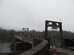
322:. The river is approximately 800 feet wide at this point. One span of it was carried away in the flood of 1903. That section of the bridge was rebuilt as a steel span. The bridge was used until 1946. In 1949, a new bridge was built on the piers of the original, but it was built only for foot traffic so that the people of Lumberville could have access to the
70:
306:
The Black Bass Hotel was built in the early 1740s. It had many names over the years including Wall's Tavern, The
Lumberville Hotel, Temple Bar, and The Rising Sun. It fell into decline in the late 19th century, until it was purchased in 1949 by Herbert (Herbie) Ward. He revived the business and ran
307:
it until his death 54 years later. The property was purchased by Jack
Thompson, owner of the Thompson auto dealerships in Doylestown, in 2008 and underwent a major refurbishment in 2009. Thompson died in December 2020. His family continues to operate the inn and restaurant.
1442:
1248:
435:"Solebury Township Bucks County Pennsylvania, a Short History of the Township and a Report on Township Officers and Affairs", by John Richardson, Offset Service Company, Philadelphia, 1958.
295:
officer and Bucks County sheriff. He acquired 15 acres of land in 1775 and established two saw mills, a general store, and a school for surveyors. As such, it was originally named
561:
1447:
902:
862:
842:
887:
817:
772:
852:
892:
867:
832:
822:
471:
1358:
1313:
1268:
1263:
930:
792:
91:
1141:
877:
812:
554:
422:
1374:
652:
1348:
1197:
872:
807:
330:
62:
1283:
1131:
897:
787:
524:
388:
46:
667:
547:
413:
235:
827:
1369:
1045:
882:
837:
777:
752:
157:
1010:
847:
762:
145:
940:
857:
802:
757:
418:
269:
162:
539:
1364:
797:
767:
1278:
1050:
782:
713:
647:
384:
311:
17:
1318:
1237:
1005:
985:
970:
955:
228:
288:
1412:
1293:
1222:
1146:
1090:
975:
925:
1227:
1156:
1085:
1070:
995:
960:
697:
692:
687:
571:
292:
150:
1379:
1343:
1308:
1258:
1172:
1161:
1126:
935:
657:
1353:
1298:
1182:
1080:
1075:
1065:
1015:
702:
682:
632:
622:
593:
223:
123:
408:
1303:
1288:
1273:
1166:
1100:
980:
965:
950:
920:
912:
744:
718:
642:
371:
303:. The mills changed hands frequently over the next century and were ultimately abandoned in the late 1800s.
254:
247:
333:
runs along the river between
Lumberville and the river. Lumberville was the location of Lock #12, a set of
1389:
1338:
1328:
1202:
1192:
1110:
1055:
1020:
990:
677:
662:
617:
604:
334:
319:
273:
1384:
1232:
1217:
1207:
1187:
1151:
1136:
1115:
1095:
1000:
945:
723:
707:
672:
637:
612:
529:
342:
323:
277:
1419:
1333:
1323:
1177:
1120:
1105:
1040:
627:
364:
338:
196:
1060:
1030:
1243:
1212:
354:
186:
497:
472:"Family, friends mourning loss of prominent Doylestown businessmen Thompson, Rutherford"
315:
265:
1436:
326:
commuter passenger service in Raven Rock. The rail service was discontinued in 1952.
138:
586:
358:
133:
106:
93:
177:
1403:‡This populated place also has portions in an adjacent county or counties
281:
211:
445:
253:
246:
203:
182:
519:
543:
732:
1443:
Unincorporated communities in Bucks County, Pennsylvania
345:. The lock house was washed away in the flood of 1955.
25:
337:
to raise and lower the barges that travelled between
272:, United States. It is located seven miles north of
1398:
1029:
911:
743:
603:
234:
222:
210:
193:
176:
168:
156:
144:
132:
122:
30:
361:were married in Lumberville on September 1, 1946
370:From 1839 to 1840, Lumberville was the home of
555:
8:
16:For a second Lumberville, Pennsylvania, see
331:Delaware Division of the Pennsylvania Canal
1448:Unincorporated communities in Pennsylvania
562:
548:
540:
27:
423:United States Department of the Interior
400:
233:
209:
175:
167:
121:
86:
55:
43:
520:"National Register Information System"
500:. Binder & Kelly. pp. 384–385
221:
192:
155:
143:
131:
7:
525:National Register of Historic Places
389:National Register of Historic Places
414:Geographic Names Information System
69:
570:Municipalities and communities of
14:
68:
61:
45:
419:United States Geological Survey
270:Solebury Township, Pennsylvania
1:
496:Hotchkin, Rev. S. F. (1892).
385:Lumberville Historic District
18:Port Providence, Pennsylvania
931:Brittany Farms-The Highlands
498:"The York Road, Old and New"
287:The village was settled by
1464:
573:Bucks County, Pennsylvania
476:Bucks County Courier Times
15:
1408:
730:
584:
87:
56:
44:
37:
32:Lumberville, Pennsylvania
39:Unincorporated community
372:John Greenleaf Whittier
172:102 ft (31 m)
1249:Loux Corner (Hilltown)
737:
320:Raven Rock, New Jersey
276:and is situated along
258:
251:
736:
530:National Park Service
367:, 19th century artist
343:Bristol, Pennsylvania
324:Pennsylvania Railroad
314:was built across the
257:
250:
195: • Summer (
107:40.40667°N 75.03806°W
1421:United States portal
365:Martin Johnson Heade
264:is a village on the
51:House in Lumberville
1414:Pennsylvania portal
1370:Washington Crossing
289:Colonel George Wall
112:40.40667; -75.03806
103: /
1011:Warminster Heights
738:
387:was listed on the
259:
252:
1430:
1429:
941:Cornwells Heights
878:Upper Southampton
813:Lower Southampton
293:Revolutionary War
245:
244:
1455:
1422:
1415:
1365:Upper Black Eddy
735:
596:
589:
579:
574:
564:
557:
550:
541:
534:
533:
516:
510:
509:
507:
505:
493:
487:
486:
484:
482:
470:English, Chris.
467:
461:
460:
458:
456:
450:Black Bass Hotel
442:
436:
433:
427:
426:
405:
312:a covered bridge
297:Wall's Saw Mills
229:215, 267 and 445
200:
118:
117:
115:
114:
113:
108:
104:
101:
100:
99:
96:
72:
71:
65:
49:
28:
1463:
1462:
1458:
1457:
1456:
1454:
1453:
1452:
1433:
1432:
1431:
1426:
1420:
1413:
1404:
1394:
1314:Pleasant Valley
1279:Neshaminy Falls
1051:Applebachsville
1032:
1025:
907:
873:Upper Makefield
808:Lower Makefield
739:
733:
728:
714:Trumbauersville
648:Langhorne Manor
599:
594:
587:
580:
577:
572:
568:
538:
537:
532:. July 9, 2010.
518:
517:
513:
503:
501:
495:
494:
490:
480:
478:
469:
468:
464:
454:
452:
444:
443:
439:
434:
430:
407:
406:
402:
397:
381:
351:
218:
194:
111:
109:
105:
102:
97:
94:
92:
90:
89:
83:
82:
81:
80:
79:
78:
77:
73:
52:
40:
33:
26:
21:
12:
11:
5:
1461:
1459:
1451:
1450:
1445:
1435:
1434:
1428:
1427:
1425:
1424:
1417:
1409:
1406:
1405:
1402:
1400:
1396:
1395:
1393:
1392:
1387:
1382:
1377:
1372:
1367:
1362:
1356:
1351:
1346:
1341:
1336:
1331:
1326:
1321:
1319:Point Pleasant
1316:
1311:
1306:
1301:
1296:
1291:
1286:
1281:
1276:
1271:
1269:Mount Pleasant
1266:
1264:Mechanicsville
1261:
1256:
1251:
1246:
1241:
1238:Line Lexington
1235:
1230:
1225:
1220:
1215:
1210:
1205:
1200:
1195:
1190:
1185:
1180:
1175:
1170:
1164:
1159:
1154:
1149:
1144:
1139:
1134:
1129:
1124:
1118:
1113:
1108:
1103:
1098:
1093:
1088:
1083:
1078:
1073:
1068:
1063:
1058:
1053:
1048:
1043:
1037:
1035:
1031:Unincorporated
1027:
1026:
1024:
1023:
1018:
1013:
1008:
1006:Village Shires
1003:
998:
993:
988:
986:Plumsteadville
983:
978:
973:
971:Milford Square
968:
963:
958:
956:Fairless Hills
953:
948:
943:
938:
933:
928:
923:
917:
915:
909:
908:
906:
905:
900:
895:
890:
885:
880:
875:
870:
865:
860:
855:
850:
845:
840:
835:
830:
825:
820:
815:
810:
805:
800:
795:
790:
785:
780:
775:
770:
765:
760:
755:
749:
747:
741:
740:
731:
729:
727:
726:
721:
716:
711:
705:
700:
695:
690:
685:
680:
675:
670:
665:
660:
655:
650:
645:
640:
635:
630:
625:
620:
615:
609:
607:
601:
600:
585:
582:
581:
569:
567:
566:
559:
552:
544:
536:
535:
511:
488:
462:
437:
428:
399:
398:
396:
393:
380:
377:
376:
375:
368:
362:
350:
349:Notable people
347:
316:Delaware River
266:Delaware River
243:
242:
239:
232:
231:
226:
220:
219:
216:
214:
208:
207:
201:
191:
190:
180:
174:
173:
170:
166:
165:
160:
154:
153:
148:
142:
141:
136:
130:
129:
126:
120:
119:
85:
84:
75:
74:
67:
66:
60:
59:
58:
57:
54:
53:
50:
42:
41:
38:
35:
34:
31:
24:
13:
10:
9:
6:
4:
3:
2:
1460:
1449:
1446:
1444:
1441:
1440:
1438:
1423:
1418:
1416:
1411:
1410:
1407:
1401:
1397:
1391:
1388:
1386:
1383:
1381:
1378:
1376:
1373:
1371:
1368:
1366:
1363:
1360:
1357:
1355:
1352:
1350:
1347:
1345:
1342:
1340:
1337:
1335:
1332:
1330:
1327:
1325:
1322:
1320:
1317:
1315:
1312:
1310:
1307:
1305:
1302:
1300:
1297:
1295:
1294:Oxford Valley
1292:
1290:
1287:
1285:
1282:
1280:
1277:
1275:
1272:
1270:
1267:
1265:
1262:
1260:
1257:
1255:
1252:
1250:
1247:
1245:
1242:
1239:
1236:
1234:
1231:
1229:
1226:
1224:
1223:Kintnersville
1221:
1219:
1216:
1214:
1211:
1209:
1206:
1204:
1201:
1199:
1196:
1194:
1191:
1189:
1186:
1184:
1181:
1179:
1176:
1174:
1171:
1168:
1165:
1163:
1160:
1158:
1155:
1153:
1150:
1148:
1147:Fountainville
1145:
1143:
1140:
1138:
1135:
1133:
1130:
1128:
1125:
1122:
1119:
1117:
1114:
1112:
1109:
1107:
1104:
1102:
1099:
1097:
1094:
1092:
1091:Centre Bridge
1089:
1087:
1084:
1082:
1079:
1077:
1074:
1072:
1069:
1067:
1064:
1062:
1059:
1057:
1054:
1052:
1049:
1047:
1044:
1042:
1039:
1038:
1036:
1034:
1028:
1022:
1019:
1017:
1014:
1012:
1009:
1007:
1004:
1002:
999:
997:
994:
992:
989:
987:
984:
982:
979:
977:
976:Newtown Grant
974:
972:
969:
967:
964:
962:
959:
957:
954:
952:
949:
947:
944:
942:
939:
937:
934:
932:
929:
927:
926:Blooming Glen
924:
922:
919:
918:
916:
914:
910:
904:
901:
899:
898:West Rockhill
896:
894:
891:
889:
886:
884:
881:
879:
876:
874:
871:
869:
866:
864:
861:
859:
856:
854:
851:
849:
846:
844:
841:
839:
836:
834:
831:
829:
826:
824:
821:
819:
816:
814:
811:
809:
806:
804:
801:
799:
796:
794:
791:
789:
788:East Rockhill
786:
784:
781:
779:
776:
774:
771:
769:
766:
764:
761:
759:
756:
754:
751:
750:
748:
746:
742:
725:
722:
720:
717:
715:
712:
709:
706:
704:
701:
699:
696:
694:
691:
689:
686:
684:
681:
679:
676:
674:
671:
669:
666:
664:
661:
659:
656:
654:
651:
649:
646:
644:
641:
639:
636:
634:
631:
629:
626:
624:
621:
619:
616:
614:
611:
610:
608:
606:
602:
598:
597:
590:
583:
578:United States
575:
565:
560:
558:
553:
551:
546:
545:
542:
531:
527:
526:
521:
515:
512:
499:
492:
489:
477:
473:
466:
463:
451:
447:
441:
438:
432:
429:
424:
420:
416:
415:
410:
409:"Lumberville"
404:
401:
394:
392:
390:
386:
379:Historic site
378:
373:
369:
366:
363:
360:
356:
353:
352:
348:
346:
344:
340:
336:
332:
327:
325:
321:
317:
313:
308:
304:
302:
301:Walls Landing
298:
294:
290:
285:
283:
279:
275:
271:
267:
263:
256:
249:
240:
237:
230:
227:
225:
215:
213:
205:
202:
198:
188:
187:Eastern (EST)
184:
181:
179:
171:
164:
161:
159:
152:
149:
147:
140:
137:
135:
128:United States
127:
125:
116:
88:Coordinates:
64:
48:
36:
29:
23:
19:
1253:
1228:Kulps Corner
1157:Gallows Hill
1142:Forest Grove
1086:Carversville
1071:Brick Tavern
996:Spinnerstown
961:Feasterville
698:Sellersville
693:Riegelsville
688:Richlandtown
592:
523:
514:
502:. Retrieved
491:
479:. Retrieved
475:
465:
453:. Retrieved
449:
440:
431:
412:
403:
382:
328:
309:
305:
300:
296:
286:
261:
260:
224:Area code(s)
139:Pennsylvania
22:
1380:Wrightstown
1375:White Horse
1344:Southampton
1309:Pipersville
1259:Maple Beach
1254:Lumberville
1173:Hagersville
1162:Gardenville
1127:Fallsington
1033:communities
936:Churchville
903:Wrightstown
863:Springfield
843:Northampton
828:New Britain
658:New Britain
653:Morrisville
588:County seat
359:Julia Child
262:Lumberville
110: /
76:Lumberville
1437:Categories
1359:Unionville
1354:Uhlerstown
1349:Springtown
1299:Penns Park
1198:Hinkletown
1183:Hartsville
1081:Bucksville
1076:Buckingham
1066:Bedminster
1016:Woodbourne
888:Warrington
883:Warminster
838:Nockamixon
818:Middletown
778:Doylestown
773:Buckingham
753:Bedminster
703:Silverdale
683:Quakertown
633:Hulmeville
623:Doylestown
595:Doylestown
395:References
284:is 18933.
278:River Road
238:feature ID
98:75°02′17″W
95:40°24′24″N
1399:Footnotes
1304:Pineville
1289:Ottsville
1274:Neshaminy
1167:Geryville
1101:Dolington
966:Levittown
951:Eddington
921:Andalusia
848:Plumstead
763:Bridgeton
745:Townships
719:Tullytown
643:Langhorne
446:"History"
391:in 1984.
310:In 1835,
178:Time zone
169:Elevation
1390:Zionhill
1339:Solebury
1329:Rushland
1284:Newville
1203:Holicong
1193:Hilltown
1132:Ferndale
1111:Elephant
1056:Aquetong
1021:Woodside
991:Richboro
981:Parkland
858:Solebury
853:Richland
803:Hilltown
758:Bensalem
678:Perkasie
663:New Hope
618:Chalfont
605:Boroughs
504:April 6,
455:July 10,
282:ZIP Code
274:New Hope
212:ZIP Code
163:Solebury
158:Township
1385:Wycombe
1233:Lahaska
1218:Jamison
1208:Holland
1188:Highton
1152:Furlong
1137:Finland
1116:Erwinna
1096:Danboro
1001:Trevose
946:Croydon
893:Warwick
868:Tinicum
833:Newtown
823:Milford
798:Haycock
768:Bristol
724:Yardley
708:Telford
673:Penndel
668:Newtown
638:Ivyland
613:Bristol
481:July 8,
241:1180077
124:Country
1334:Shelly
1324:Revere
1178:Harrow
1121:Eureka
1106:Durham
1041:Almont
783:Durham
628:Dublin
339:Easton
280:. Its
146:County
1061:Argus
1046:Amity
793:Falls
335:locks
217:18933
206:(EDT)
204:UTC-4
183:UTC-5
151:Bucks
134:State
1244:Lodi
1213:Hood
913:CDPs
506:2014
483:2021
457:2021
383:The
357:and
355:Paul
341:and
329:The
299:and
291:, a
236:GNIS
318:to
268:in
197:DST
1439::
591::
576:,
528:.
522:.
474:.
448:.
421:,
417:.
411:.
1361:‡
1240:‡
1169:‡
1123:‡
710:‡
563:e
556:t
549:v
508:.
485:.
459:.
425:.
374:.
199:)
189:)
185:(
20:.
Text is available under the Creative Commons Attribution-ShareAlike License. Additional terms may apply.