191:
229:
88:
20:
305:
207:
of the southeastern part, a wall was therefore built that divided the harbor into two parts and acted as a barrier. Although the sheltered part of the harbor held out longer than the rest of the basin, it too was eventually filled in by sediment. Due to that, from the 12th to 13th centuries the
153:), just south of the Fifth Military Gate, passed under the walls and entered the city. At that point a tower, now known as "Sulukule," meaning "water tower", protected the river. The creek continued its course inside the walls, in a valley made fertile by the watercourse, named for that reason
293:
sector, the final attack in the creek valley. In anticipation of this, the sultan set up his tent in the high ground to the left of the Lycus. His plan succeeded, and it was from a breach between the Gate of St. Romanus and the Fifth
Military Gate, on the right bank of the stream, that the
202:
Although the water regime of the watercourse was stream-like, and thus with little water for most of the year, the heavy rains that fell especially in
February brought a lot of dirt into the stream, which flowed into the west and northwest parts of the harbor. To prevent the
315:
The valley remained sparsely inhabited and cultivated with gardens until
Istanbul's explosive population increase, but then the area under vegetable gardens began to decline until it disappeared in the late twentieth century. In the period 1956–1957 a new road, the
274:) fell from his horse and died. Ancient Ottoman maps of the city show that the lower course of the creek, south of the Lips monastery, had become a subterranean waterway. There are hints that these works were done during the Byzantine period.
190:
98:
The Lycus, which was six kilometers long, was the only drainage channel for the walled city. The maximum width of the valley it formed was 3.5 km and occupied one-third of the area of
259:, but it was a favored place for the settlement of Greek Orthodox monasteries: famous were those of Dios and Ikasia (or Cassia), Cocorobion and
228:
650:
195:
384:
285:
in Greek, was lower than the surrounding heights, and because of that was the weakest of the entire defensive circle. The
Ottoman sultan
385:"Bayrampasa (Lykos) Deresi Havzası ve Ağzındaki Yenikapı (Theodosius Limanı) Limanı Kıyı Alanındaki (Marmara Denizi) Değişim Süreçleri"
324:), was built directly over the riverbed, which was then covered over. The Lycus was briefly uncovered during the construction of the
719:
698:
676:
169:. There it turned abruptly southward, touching the heights of Avretpazar, running just before its mouth through a plain called
87:
740:
134:
745:
668:
638:
565:
289:
was fully aware of this, and in fact the plan of the siege included, after the wearing down of the walls in the
108:
Its springs are located in the heights of the Topçular neighborhood, in the northern part of the present-day
750:
612:
278:
142:
129:
125:
755:
416:
298:
249:
184:
76:
41:
63:(today's Istanbul), which was important for historical reasons. The only waterway present within the
643:
Bildlexikon zur
Topographie Istanbuls: Byzantion, Konstantinupolis, Istanbul bis zum Beginn d. 17 Jh
212:
caused by the creek gradually caused the harbor to disappear, creating in its place the area called
325:
616:
329:
715:
694:
672:
646:
388:
260:
162:
150:
19:
256:
158:
117:
99:
52:
689:(2001). "The shoreline of Constantinople in the fourth century". In Nevra Necipoğlu (ed.).
176:
23:
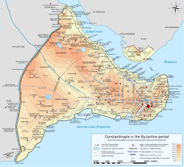
Map of
Byzantine Constantinople. The Lycus runs through the city from northwest to south
710:
Decker, Michael; Nicholson, Oliver (2018). "Roman and post-Roman hunting and hawking".
295:
180:
171:
130:
seventh hill of the city (located to the west) from the third, fourth, fifth, and sixth
102:
60:
32:
534:
734:
626:
264:
146:
109:
91:
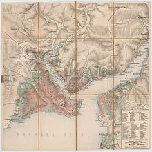
Constantinople map from 1860 to 1870 with the Lycus Valley in evidence within the
232:
The Lycus valley at the
Theodosian walls looking north at the end of 19th century
686:
660:
166:
466:
618:
Byzantine
Constantinople: The Walls of the City and Adjoining Historical Sites
290:
286:
245:
209:
204:
304:
175:("white palace" in Turkish), perhaps after a building inhabited by Empress
220:, which was used for vegetable cultivation until relatively recent times.
237:
145:
between the gates of
Carisius and St. Romanus (corresponding to modern
113:
179:
in the early ninth century. The watercourse finally flowed into the
263:. In 450, while hunting in the valley near Constantinople, Emperor
303:
241:
227:
189:
92:
86:
64:
691:
244:
and later then due to sea level rise a body of water, hosted a
132:. Administratively, it marked the boundary between the twelfth
16:
Stream that is now vaulted over that flowed in Constantinople
633:(in French). Paris: Institut Français d'Etudes Byzantines.
467:"Aqueducts and the Water Supply System of Constantinople"
281:
which crossed the valley in the north of the city, named
248:
settlement, and eventually the area became the Byzantine
75:) avenue. The creek valley played a crucial role in the
566:"The final siege and fall of Constantinople (1453)"
46:
161:) by Turks. It headed southeast, passing south of
255:The Lycus valley was never much inhabited in the
138:(located to the west) and the rest of the city.
59:) is a stream, now vaulted over, that flowed in
183:at the Harbour of Theodosius, also called the
112:district, about 3.5 km northwest of the
8:
387:(in Turkish). 3 August 2010. Archived from
67:, it was covered in the 1950s to build the
128:. Geographically, the creek separated the
452:
450:
194:The Lycus valley near the walls with the
559:
557:
555:
520:
518:
440:
438:
328:, which connects the city center to the
18:
712:The Oxford Dictionary of Late Antiquity
487:
485:
483:
379:
377:
375:
373:
371:
341:
311:, the avenue which covers the Lycus bed
621:. London, United Kingdom: John Murray.
417:"Tarih çınarı eski İstanbul'u anlattı"
361:
359:
357:
355:
353:
351:
349:
347:
345:
198:in the background in an 1836 engraving
411:
409:
407:
7:
714:. Oxford: Oxford University Press.
14:
645:(in German). Tübingen: Wasmuth.
301:on the morning of May 29, 1453.
269:
1:
509:Decker and Nicholson (2018),
322:Adnan Menderes Vatan Caddesi
73:Adnan Menderes Vatan Caddesi
500:Müller-Wiener (1977), p. 22
423:(in Turkish). 18 March 2010
47:
772:
669:W. W. Norton & Company
36:
631:Constantinople Byzantine
613:van Millingen, Alexander
639:Müller-Wiener, Wolfgang
143:walls of Constantinople
456:Janin (1950), p. 47-48
312:
309:Adnan Menderes Caddesi
233:
199:
196:Mihrimah Sultan Mosque
185:Harbour of Eleutherios
141:The Lycus reached the
121:
95:
77:Fall of Constantinople
56:
24:
741:Geography of Istanbul
570:Büyük İstanbul Tarihi
307:
250:harbour of Theodosius
231:
193:
90:
22:
598:Freely (1991) p. 257
589:Freely (1991) p. 279
539:The Byzantine Legacy
491:Janin (1950), p. 219
444:Freely (1991) p. 215
391:on 12 December 2015.
93:historical peninsula
665:Blue Guide Istanbul
564:Feridun M. Emecen.
524:Mango (2001), p. 20
401:Janin (1950), p. 62
365:Janin (1950), p. 12
299:penetrated the city
116:(Adrianople) Gate (
535:"Theodosian Walls"
313:
234:
200:
96:
25:
693:. Leiden: Brill.
652:978-3-8030-1022-3
157:("new garden" in
57:Bayrampaşa Deresi
45:
763:
746:Rivers of Turkey
725:
704:
682:
656:
634:
622:
599:
596:
590:
587:
581:
580:
578:
576:
561:
550:
549:
547:
545:
531:
525:
522:
513:
507:
501:
498:
492:
489:
478:
477:
475:
473:
463:
457:
454:
445:
442:
433:
432:
430:
428:
413:
402:
399:
393:
392:
381:
366:
363:
273:
271:
257:Byzantine period
236:The area of its
165:and reached the
126:Theodosian walls
50:
40:
38:
771:
770:
766:
765:
764:
762:
761:
760:
731:
730:
722:
709:
701:
685:
679:
659:
653:
637:
625:
611:
608:
603:
602:
597:
593:
588:
584:
574:
572:
563:
562:
553:
543:
541:
533:
532:
528:
523:
516:
508:
504:
499:
495:
490:
481:
471:
469:
465:
464:
460:
455:
448:
443:
436:
426:
424:
415:
414:
405:
400:
396:
383:
382:
369:
364:
343:
338:
330:Atatürk Airport
277:The section of
268:
240:, originally a
226:
85:
51:, lit. "wolf";
17:
12:
11:
5:
769:
767:
759:
758:
753:
751:Constantinople
748:
743:
733:
732:
727:
726:
720:
706:
705:
699:
683:
677:
667:(3 ed.).
657:
651:
635:
627:Janin, Raymond
623:
607:
604:
601:
600:
591:
582:
551:
526:
514:
502:
493:
479:
458:
446:
434:
403:
394:
367:
340:
339:
337:
334:
326:M1 subway line
279:the city walls
272: 402–450
225:
222:
181:Sea of Marmara
163:Lips Monastery
103:Constantinople
84:
81:
61:Constantinople
15:
13:
10:
9:
6:
4:
3:
2:
768:
757:
756:Former rivers
754:
752:
749:
747:
744:
742:
739:
738:
736:
729:
723:
721:9780198662778
717:
713:
708:
707:
702:
700:90-04-11625-7
696:
692:
688:
684:
680:
678:0-393-30728-X
674:
670:
666:
662:
658:
654:
648:
644:
640:
636:
632:
628:
624:
620:
619:
614:
610:
609:
605:
595:
592:
586:
583:
571:
567:
560:
558:
556:
552:
540:
536:
530:
527:
521:
519:
515:
512:
506:
503:
497:
494:
488:
486:
484:
480:
468:
462:
459:
453:
451:
447:
441:
439:
435:
422:
418:
412:
410:
408:
404:
398:
395:
390:
386:
380:
378:
376:
374:
372:
368:
362:
360:
358:
356:
354:
352:
350:
348:
346:
342:
335:
333:
331:
327:
323:
319:
318:Vatan Caddesi
310:
306:
302:
300:
297:
292:
288:
284:
280:
275:
266:
265:Theodosius II
262:
258:
253:
251:
247:
243:
239:
230:
223:
221:
219:
215:
211:
206:
197:
192:
188:
186:
182:
178:
174:
173:
168:
164:
160:
156:
152:
148:
144:
139:
137:
136:
131:
127:
123:
122:Edirne Kapişi
119:
115:
111:
106:
104:
101:
94:
89:
82:
80:
78:
74:
70:
69:Vatan Caddesi
66:
62:
58:
54:
49:
43:
34:
30:
21:
728:
711:
690:
687:Mango, Cyril
664:
661:Freely, John
642:
630:
617:
594:
585:
573:. Retrieved
569:
542:. Retrieved
538:
529:
510:
505:
496:
470:. Retrieved
461:
425:. Retrieved
420:
397:
389:the original
321:
317:
314:
308:
283:Mesoteichion
282:
276:
254:
235:
218:Langabostanı
217:
213:
201:
170:
154:
140:
133:
107:
97:
72:
68:
28:
26:
167:Forum Bovis
65:walled city
735:Categories
291:Blachernae
205:silting up
147:Edirnekapı
110:Bayrampaşa
287:Mehmet II
246:Neolithic
210:siltation
155:Yenibahce
124:) of the
100:Byzantine
79:in 1453.
42:romanized
663:(1991).
641:(1977).
629:(1950).
615:(1899).
511:sub voce
427:28 April
421:Hürriyet
296:Ottomans
606:Sources
238:estuary
224:History
172:Aksaray
159:Turkish
151:Topkapı
118:Turkish
53:Turkish
44::
718:
697:
675:
649:
575:27 May
544:27 May
472:23 May
214:Vlanga
114:Edirne
83:Course
336:Notes
320:(now
242:marsh
177:Irene
135:regio
71:(now
48:Lykos
37:Λύκος
33:Greek
29:Lycus
716:ISBN
695:ISBN
673:ISBN
647:ISBN
577:2024
546:2024
474:2024
429:2024
261:Lips
149:and
27:The
216:or
737::
671:.
568:.
554:^
537:.
517:^
482:^
449:^
437:^
419:.
406:^
370:^
344:^
332:.
270:r.
252:.
187:.
120::
105:.
55::
39:,
35::
724:.
703:.
681:.
655:.
579:.
548:.
476:.
431:.
267:(
31:(
Text is available under the Creative Commons Attribution-ShareAlike License. Additional terms may apply.