315:). Services inevitably became concentrated at the Aulac exit, where the PEI route branches, and LaPlanche Street's economy began to fade. Various bridges and sections of LaPlanche Street were dismantled and the street was divided into three disconnected segments. The Sackville segment (Bridge Street) remains vital, while Aulac and Amherst's host numerous dilapidated shops, plants and motels, and serve the fringe economy and culture of the two communities, masking the centuries of history for which it was stage.
329:
208:
378:
248:
167:
88:
17:
275:
Co., Malleable Iron Co., McLean
Milling Co., Oxford Worsted Co., Hewson Woolen Mills, Eastern Pants Co., M. Shane & Co., News Publishing Co., and E. Biden & Sons. As more advanced industrial centres developed elsewhere, LaPlanche's industry fell into disuse. In the 1960s it was replaced by a
190:
of 400 men stormed the fort in 1776. The
British successfully defended and thus ensured loyalty to the British throne for Nova Scotia during the revolution. In the decades to follow Amherst, Sackville and Aulac (LaPlanche Street's midpoint) would be populated by waves of English-speaking settlers,
263:) was Amherst's old industrial park immediately before its downtown. The LaPlanche industrial park manufactured railway passenger and freight cars, boilers, engines, automobile parts and generator plants and was home to the
397:
Aulac Ridge: The site of Aulac, NB and Fort Beauséjour – Fort
Cumberland. Formerly Beauséjour Ridge. Between Fort Lawrence Ridge and Aulac Ridge is Tongue's Island, the former seat of the Acadian Government.
223:, the ship railway would have been one of the most impressive engineering feats of its day. The railway would use two steam locomotives to transport small cargo and passenger ships between the upper
303:
The 1960s saw the Trans-Canada
Highway system being upgraded to four-lane expressways. This included a new route between Sackville and Amherst running roughly parallel to LaPlanche Street (
644:
634:
639:
629:
291:(Sackville), Eva's Place (Aulac), and The Hampton Diner (Fort Lawrence). Nova Scotia built its Tourist Welcome Centre on LaPlanche Street in Fort Lawrence, placing it
496:
196:
135:, just west of Amherst, NS) was built by British troops on LaPlanche Street to defend the border of Nova Scotia. In response, the French built
111:. This would eventually extend into the principal route between Continental Acadia (New Brunswick) and (then) Peninsular Acadia (Nova Scotia).
374:. The isthmus is made up of the Tantramar Marshes, at sea level, and four ridges that emerge from the Bay of Fundy and rise north-easterly:
545:
255:
Both
Sackville and Amherst would develop into industrial towns. On the western end of LaPlanche Street (now called Bridge Street,
523:
231:, with the potential to reduce the 800 kilometre journey-by-sea around Nova Scotia to a mere 24 kilometres. It ran between
144:
64:
155:. Recognizing its superiority, the British burned their own Fort Lawrence and moved into Fort Beauséjour, renaming it
232:
179:
128:
76:
183:
72:
288:
268:
156:
312:
304:
256:
431:
239:
on the, Northumberland Strait. In 1891, federal funding was withdrawn and the project never saw fruition.
216:
56:
570:
590:
367:
355:
260:
228:
148:
287:, LaPlanche hosted many tourist-oriented businesses. It sustained three diners famous in local memory:
453:
443:
371:
337:
284:
277:
264:
236:
192:
108:
40:
565:
508:
391:
308:
68:
487:
Ernest Clarke, The siege of Fort
Cumberland, 1776, McGill Queen's University Press, 1995. pp. 215-
438:
136:
417:
351:
44:
609:
472:
448:
272:
132:
549:
527:
400:
Sackville Ridge: Site of
Sackville, NB on its eastern edge and Dorchester, NB on its west.
152:
542:
328:
170:
The southern dock of the
Chignecto Ship Railway, on the Missaguash River, Fort Lawrence
160:
623:
359:
220:
175:
124:
52:
32:
520:
259:) was Sackville's downtown core. On the eastern end (still called LaPlanche Street,
207:
363:
224:
104:
48:
28:
377:
247:
423:
404:
387:
166:
100:
119:
As the major throughway between two rival colonies, British Nova Scotia and
87:
473:
History: Fort Beauséjour – Fort
Cumberland National Historic Site of Canada
386:
Fort
Lawrence Ridge: The site of Amherst, NS and the historic location of
16:
342:
LaPlanche Street traverses the low-lying, southern edge of the Chignecto
96:
581:
343:
187:
347:
120:
60:
36:
283:
As the major throughway between mainland Canada and Nova Scotia and
427:
376:
358:
to Amherst, Nova Scotia and has as its two oceanic boundaries the
346:, which connects Nova Scotia with New Brunswick and thus mainland
327:
246:
206:
165:
140:
107:" and describes a plank-bridge route over what is now also called
91:
Fort Beauséjour - Fort Cumberland National Historic Site of Canada
86:
15:
600:
509:
The Chignecto Ship Railway: a 19th century engineering innovation
511:." Canadian Journal of Civil Engineering 19, 1 (1992): 164-177.
613:
215:
La Planche Street would also serve as the southern end of the
595:
University of New Brunswick Archives and Special Collections
211:
Maleable Iron Works, LaPlanche Street, Amherst, Nova Scotia
426:
that stretched 10 km inland from the Chignecto Bay.
430:
by the Acadians, they are now fertile hay fields and a
574:
67:, the key battle between the two colonies during the
123:, early LaPlanche was guarded by two forts. In 1750
163:began in Beaubassin immediately after this battle.
552:, by W. C. Milner. "Cumberland Regional Library."
434:. The marshes are drained by four tidal rivers:
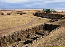
20:A view from LaPlanche Street near Sackville, NB
151:, Fort Beauséjour fell to the British, led by
127:(located in the present-day community called
8:
407:; between Petitcodiac and Memramcook Rivers.
582:Marshland: Records of Life on the Tantramar
55:. Historically, it hosted the key forts of
645:Historic trails and roads in New Brunswick
635:Roads in Westmorland County, New Brunswick
568:. A project researching LaPlanche Street.
332:An historic map of the Chignecto Isthmus.
640:Historic trails and roads in Nova Scotia
630:Roads in Cumberland County, Nova Scotia
497:Migration from Yorkshire to Nova Scotia
465:
276:newer, smaller industrial park on the
219:- had it been completed. Designed by
99:, the Tantramar community was called
7:
390:, Acadia's second settlement (after
610:Diner's Era Ends: The Hampton Diner
586:Mount Allison University Archives.
477:Parks Canada, Government of Canada
27:is the historic connector between
14:
605:Sackville, New Brunswick, Canada.
422:The Tantramar Marshes were once
147:(1755), the opening mark of the
394:), and Britain's Fort Lawrence.
295:the east and west-bound lanes.
95:When originally settled by the
1:
350:. The Isthmus runs from the
532:Cumberland Regional Library
251:The historic Hampton Diner.
153:Lieutenant-Colonel Monckton
661:
591:The Chignecto Ship Railway
415:
403:Memramcook Ridge: Site of
335:
233:Fort Lawrence, Nova Scotia
180:American Revolutionary War
77:American Revolutionary War
184:Battle of Fort Cumberland
145:Battle of Fort Beauséjour
139:on Beauséjour ridge (now
73:Battle of Fort Cumberland
65:Battle of Fort Beauséjour
601:Tantramar Heritage Trust
575:Mount Allison University
566:The Lost Highway Project
269:Canadian Car and Foundry
103:. La Planche means "the
43:, LaPlanche crosses the
313:New Brunswick Highway 2
305:Nova Scotia Highway 104
235:, outside Amherst, and
521:The History of Amherst
432:National Wildlife Area
382:
333:
252:
217:Chignecto Ship Railway
212:
171:
92:
57:peninsular Nova Scotia
21:
381:The Missaguash River.
380:
368:Northumberland Strait
362:, a sub-basin of the
356:Dieppe, New Brunswick
331:
250:
229:Northumberland Strait
210:
169:
149:French and Indian War
90:
19:
543:History of Chignecto
372:Gulf of St. Lawrence
338:Isthmus of Chignecto
285:Prince Edward Island
278:Trans-Canada Highway
265:Rhodes Curry Company
193:New England Planters
182:to Nova Scotia with
41:Isthmus of Chignecto
530:by J. A. Blanche.
309:Nova Scotia Trunk 2
178:tried to bring the
174:Two decades later,
614:Amherst Daily News
548:2009-05-22 at the
526:2009-05-22 at the
383:
334:
253:
213:
197:Yorkshire settlers
172:
93:
63:and witnessed the
22:
418:Tantramar Marshes
412:Tantramar Marshes
352:Petitcodiac River
324:Chignecto Isthmus
45:Tantramar Marshes
39:. Located on the
652:
553:
540:
534:
518:
512:
505:
499:
494:
488:
485:
479:
470:
449:Missaguash River
370:, an arm of the
273:Robb Engineering
133:Missaguash River
69:Seven Years' War
59:and continental
25:LaPlanche Street
660:
659:
655:
654:
653:
651:
650:
649:
620:
619:
562:
557:
556:
550:Wayback Machine
541:
537:
528:Wayback Machine
519:
515:
506:
502:
495:
491:
486:
482:
471:
467:
462:
454:Tantramar River
444:LaPlanche River
420:
414:
340:
326:
321:
301:
245:
205:
186:. Eddy and his
157:Fort Cumberland
143:Ridge). In the
137:Fort Beauséjour
117:
109:Laplanche River
85:
12:
11:
5:
658:
656:
648:
647:
642:
637:
632:
622:
621:
618:
617:
607:
598:
588:
579:
561:
560:External links
558:
555:
554:
535:
513:
507:Ircha M. C., "
500:
489:
480:
464:
463:
461:
458:
457:
456:
451:
446:
441:
416:Main article:
413:
410:
409:
408:
401:
398:
395:
336:Main article:
325:
322:
320:
317:
300:
297:
289:Mel's Tea Room
244:
241:
204:
201:
161:Great Upheaval
116:
113:
84:
81:
13:
10:
9:
6:
4:
3:
2:
657:
646:
643:
641:
638:
636:
633:
631:
628:
627:
625:
615:
611:
608:
606:
602:
599:
596:
592:
589:
587:
583:
580:
577:
576:
572:
567:
564:
563:
559:
551:
547:
544:
539:
536:
533:
529:
525:
522:
517:
514:
510:
504:
501:
498:
493:
490:
484:
481:
478:
474:
469:
466:
459:
455:
452:
450:
447:
445:
442:
440:
437:
436:
435:
433:
429:
425:
419:
411:
406:
402:
399:
396:
393:
389:
385:
384:
379:
375:
373:
369:
365:
361:
360:Chignecto Bay
357:
353:
349:
345:
339:
330:
323:
318:
316:
314:
310:
306:
298:
296:
294:
290:
286:
281:
279:
274:
270:
266:
262:
258:
249:
242:
240:
238:
234:
230:
226:
222:
221:Henry Ketchum
218:
209:
202:
200:
198:
194:
189:
185:
181:
177:
176:Jonathan Eddy
168:
164:
162:
158:
154:
150:
146:
142:
138:
134:
130:
129:Fort Lawrence
126:
125:Fort Lawrence
122:
114:
112:
110:
106:
102:
98:
89:
82:
80:
78:
74:
70:
66:
62:
58:
54:
53:Sackville, NB
50:
46:
42:
38:
34:
33:New Brunswick
30:
26:
18:
604:
594:
585:
569:
538:
531:
516:
503:
492:
483:
476:
468:
424:salt marshes
421:
364:Bay of Fundy
341:
302:
292:
282:
261:NS Route 204
257:NB Route 106
254:
225:Bay of Fundy
214:
173:
159:. Acadia's
118:
94:
24:
23:
612:. From the
439:Aulac River
191:namely the
49:Amherst, NS
29:Nova Scotia
624:Categories
460:References
405:Memramcook
392:Port Royal
388:Beaubassin
366:, and the
101:Beaubassin
71:, and the
319:Geography
546:Archived
524:Archived
311:meeting
227:and the
195:and the
97:Acadians
47:between
344:Isthmus
293:between
237:Tidnish
188:militia
131:on the
83:History
75:of the
571:CHARTS
348:Canada
267:, the
121:Acadia
61:Acadia
37:Canada
428:Diked
271:Co.,
243:1900s
203:1800s
141:Aulac
115:1700s
105:plank
51:and
31:and
603:.
593:.
584:.
475:.
354:in
299:Now
626::
573:,
280:.
199:.
79:.
35:,
616:.
597:.
578:.
307:-
Text is available under the Creative Commons Attribution-ShareAlike License. Additional terms may apply.