65:
1155:
42:
118:
138:
687:
living together, 12.1% had a female householder with no husband present, 7.3% had a male householder with no wife present, and 41.2% were non-families. 31.5% of all households were made up of individuals, and 14.5% had someone living alone who was 65 years of age or older. The average household size
735:
In the village, the population was spread out, with 23.9% under the age of 18, 7.1% from 18 to 24, 31.9% from 25 to 44, 17.5% from 45 to 64, and 19.6% who were 65 years of age or older. The median age was 38 years. For every 100 females, there were 87.4 males. For every 100 females age 18 and over,
731:
living together, 9.1% had a female householder with no husband present, and 32.6% were non-families. 24.2% of all households were made up of individuals, and 18.9% had someone living alone who was 65 years of age or older. The average household size was 2.47 and the average family size was 2.92.
691:
The median age in the village was 39.1 years. 20.4% of residents were under the age of 18; 9.1% were between the ages of 18 and 24; 27.8% were from 25 to 44; 24% were from 45 to 64; and 18.8% were 65 years of age or older. The gender makeup of the village was 51.0% male and 49.0% female.
64:
739:
The median income for a household in the village was $ 36,250, and the median income for a family was $ 42,000. Males had a median income of $ 31,953 versus $ 19,167 for females. The
660:
was 873.8 inhabitants per square mile (337.4/km). There were 172 housing units at an average density of 409.5 per square mile (158.1/km). The racial makeup of the village was 97.5%
708:
was 778.8 people per square mile (299.7/km). There were 139 housing units at an average density of 332.0 per square mile (127.8/km). The racial makeup of the village was 97.55%
373:, the village has a total area of 0.43 square miles (1.11 km), of which, 0.42 square miles (1.09 km) of it is land and 0.01 square miles (0.03 km) is water.
1082:
1545:
935:
1000:
274:
960:
A History of the Origin of the Place Names
Connected with the Chicago & North Western and Chicago, St. Paul, Minneapolis & Omaha Railways
78:
1075:
41:
1302:
284:
1347:
1297:
1262:
1352:
1277:
338:
1416:
1322:
1287:
803:
237:
1292:
1068:
832:
782:
1550:
1332:
665:
1060:
974:
721:
327:
A post office called La Valle has been in operation since 1856. La Valle is derived from the French meaning "the valley".
150:
1491:
1342:
756:
1327:
1004:
978:
914:
861:
713:
370:
1317:
1312:
1143:
760:
316:
1426:
1385:
1307:
1257:
1219:
602:
587:
572:
557:
542:
527:
512:
497:
482:
467:
452:
437:
422:
407:
312:
1515:
1209:
262:
110:
1372:
1239:
1234:
1224:
727:
There were 132 households, out of which 28.0% had children under the age of 18 living with them, 53.8% were
1456:
1446:
1189:
1092:
673:
300:
155:
1008:
1431:
1406:
1199:
1194:
683:
There were 165 households, of which 29.1% had children under the age of 18 living with them, 39.4% were
885:
636:
The economy of the village of La Valle is largely driven by tourism and the lake communities at nearby
1522:
1380:
1282:
1229:
1173:
1138:
677:
247:
50:
46:
743:
for the village was $ 16,823. None of the families and 3.1% of the population were living below the
1461:
1396:
1362:
1357:
1204:
1165:
772:
709:
669:
661:
1481:
1411:
1337:
1267:
1179:
1133:
1114:
705:
657:
54:
1030:
1471:
1466:
1451:
1441:
1436:
1421:
1272:
740:
641:
958:
1249:
1214:
1125:
704:
of 2000, there were 326 people, 132 households, and 88 families living in the village. The
656:
of 2010, there were 367 people, 165 households, and 97 families living in the village. The
1539:
1055:
778:
637:
308:
267:
123:
744:
880:
878:
1107:
759:, which has 4 elementary schools, 1 intermediate school, 1 middle school, and 1
130:
353:
340:
93:
80:
304:
228:
143:
1506:‡This populated place also has portions in an adjacent county or counties
728:
717:
684:
32:
763:. Ironton-La Valle Elementary School is the only school in La Valle.
701:
653:
254:
233:
716:, and 0.31% from two or more races. 2.15% of the population were
1064:
1153:
828:
747:, including no under eighteens and 14.3% of those over 64.
910:
857:
1501:
1480:
1395:
1371:
1248:
1164:
1124:
283:
273:
261:
244:
227:
219:
211:
203:
198:
190:
182:
174:
166:
161:
149:
129:
109:
23:
957:Chicago and North Western Railway Company (1908).
688:was 2.22 and the average family size was 2.78.
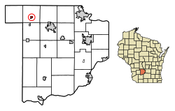
69:Location of La Valle in Sauk County, Wisconsin.
852:
850:
1076:
8:
888:. United States Census Bureau. May 24, 2020
775:, Wisconsin state legislator and politician
1083:
1069:
1061:
975:"US Gazetteer files: 2010, 2000, and 1990"
380:
20:
680:of any race were 2.2% of the population.
886:"Population and Housing Unit Estimates"
795:
272:
260:
226:
197:
189:
160:
108:
73:
61:
38:
400:
905:
903:
823:
821:
282:
243:
218:
210:
202:
181:
173:
165:
148:
128:
7:
315:. The village is located within the
672:, and 0.5% from two or more races.
186:0.01 sq mi (0.02 km)
178:0.40 sq mi (1.03 km)
170:0.41 sq mi (1.05 km)
18:Village in Wisconsin, United States
1546:Villages in Sauk County, Wisconsin
1091:Municipalities and communities of
1031:"Census of Population and Housing"
390:
14:
311:. The population was 367 at the
136:
116:
63:
40:
833:United States Geological Survey
829:"US Board on Geographic Names"
1:
806:. United States Census Bureau
223:907.04/sq mi (349.81/km)
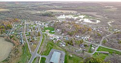
757:School District of Reedsburg
1492:Ho-Chunk Indian Reservation
1005:United States Census Bureau
979:United States Census Bureau
915:United States Census Bureau
862:United States Census Bureau
804:"2019 U.S. Gazetteer Files"
371:United States Census Bureau
307:, United States, along the
212: • Estimate
1567:
938:. Jim Forte Postal History
755:La Valle is served by the
194:1,024 ft (312 m)
1511:
1151:
1105:
1001:"US Gazetteer files 2010"
629:
616:
601:
586:
571:
556:
541:
526:
511:
496:
481:
466:
451:
436:
421:
406:
399:
394:
389:
386:
366:(43.583102, -90.131648).
74:
62:
39:
30:
736:there were 89.3 males.
335:La Valle is located at
1158:
1094:Sauk County, Wisconsin
1551:Villages in Wisconsin
1157:
911:"U.S. Census website"
858:"U.S. Census website"
630:U.S. Decennial Census
382:Historical population
354:43.58306°N 90.13139°W
246: • Summer (
94:43.58306°N 90.12972°W
1524:United States portal
220: • Density
1056:History of La Valle
981:. February 12, 2011
773:Benjamin G. Paddock
383:
359:43.58306; -90.13139
350: /
99:43.58306; -90.12972
90: /
25:La Valle, Wisconsin
1159:
835:. October 25, 2007
785:from 1955 to 1957.
783:Secretary of State
706:population density
658:population density
381:
204: • Total
183: • Water
167: • Total
1533:
1532:
741:per capita income
642:Dutch Hollow Lake
634:
633:
369:According to the
294:
293:
175: • Land
1558:
1525:
1518:
1517:Wisconsin portal
1156:
1117:
1110:
1100:
1095:
1085:
1078:
1071:
1062:
1043:
1042:
1040:
1038:
1027:
1021:
1020:
1018:
1016:
1007:. Archived from
997:
991:
990:
988:
986:
971:
965:
964:
954:
948:
947:
945:
943:
932:
926:
925:
923:
921:
907:
898:
897:
895:
893:
882:
873:
872:
870:
868:
854:
845:
844:
842:
840:
825:
816:
815:
813:
811:
800:
666:African American
402:
397:
392:
384:
365:
364:
362:
361:
360:
355:
351:
348:
347:
346:
343:
317:Town of La Valle
299:is a village in
251:
142:
140:
139:
122:
120:
119:
105:
104:
102:
101:
100:
95:
91:
88:
87:
86:
83:
67:
44:
21:
1566:
1565:
1561:
1560:
1559:
1557:
1556:
1555:
1536:
1535:
1534:
1529:
1523:
1516:
1507:
1497:
1483:
1476:
1398:
1391:
1367:
1244:
1160:
1154:
1149:
1144:Wisconsin Dells
1120:
1115:
1108:
1101:
1098:
1093:
1089:
1052:
1047:
1046:
1036:
1034:
1029:
1028:
1024:
1014:
1012:
1011:on July 2, 2012
999:
998:
994:
984:
982:
973:
972:
968:
956:
955:
951:
941:
939:
934:
933:
929:
919:
917:
909:
908:
901:
891:
889:
884:
883:
876:
866:
864:
856:
855:
848:
838:
836:
827:
826:
819:
809:
807:
802:
801:
797:
792:
769:
753:
729:married couples
698:
685:married couples
650:
395:
379:
358:
356:
352:
349:
344:
341:
339:
337:
336:
333:
325:
245:
137:
135:
117:
115:
98:
96:
92:
89:
84:
81:
79:
77:
76:
70:
58:
35:
26:
19:
12:
11:
5:
1564:
1562:
1554:
1553:
1548:
1538:
1537:
1531:
1530:
1528:
1527:
1520:
1512:
1509:
1508:
1505:
1503:
1499:
1498:
1496:
1495:
1488:
1486:
1478:
1477:
1475:
1474:
1469:
1464:
1459:
1454:
1449:
1444:
1439:
1434:
1429:
1427:Greens Corners
1424:
1419:
1414:
1409:
1403:
1401:
1397:Unincorporated
1393:
1392:
1390:
1389:
1386:Lake Wisconsin
1383:
1377:
1375:
1369:
1368:
1366:
1365:
1360:
1355:
1350:
1345:
1340:
1335:
1330:
1325:
1323:Prairie du Sac
1320:
1315:
1310:
1305:
1300:
1295:
1290:
1285:
1280:
1275:
1270:
1265:
1260:
1254:
1252:
1246:
1245:
1243:
1242:
1237:
1232:
1227:
1222:
1220:Prairie du Sac
1217:
1212:
1207:
1202:
1197:
1192:
1187:
1182:
1177:
1170:
1168:
1162:
1161:
1152:
1150:
1148:
1147:
1141:
1136:
1130:
1128:
1122:
1121:
1106:
1103:
1102:
1090:
1088:
1087:
1080:
1073:
1065:
1059:
1058:
1051:
1050:External links
1048:
1045:
1044:
1022:
992:
966:
949:
927:
899:
874:
846:
817:
794:
793:
791:
788:
787:
786:
776:
768:
767:Notable people
765:
752:
749:
697:
694:
649:
646:
632:
631:
627:
626:
623:
621:
618:
614:
613:
610:
608:
605:
599:
598:
595:
593:
590:
584:
583:
580:
578:
575:
569:
568:
565:
563:
560:
554:
553:
550:
548:
545:
539:
538:
535:
533:
530:
524:
523:
520:
518:
515:
509:
508:
505:
503:
500:
494:
493:
490:
488:
485:
479:
478:
475:
473:
470:
464:
463:
460:
458:
455:
449:
448:
445:
443:
440:
434:
433:
430:
428:
425:
419:
418:
415:
413:
410:
404:
403:
398:
393:
388:
378:
375:
332:
329:
324:
321:
292:
291:
288:
281:
280:
277:
271:
270:
265:
259:
258:
252:
242:
241:
231:
225:
224:
221:
217:
216:
213:
209:
208:
205:
201:
200:
196:
195:
192:
188:
187:
184:
180:
179:
176:
172:
171:
168:
164:
163:
159:
158:
153:
147:
146:
133:
127:
126:
113:
107:
106:
72:
71:
68:
60:
59:
45:
37:
36:
31:
28:
27:
24:
17:
13:
10:
9:
6:
4:
3:
2:
1563:
1552:
1549:
1547:
1544:
1543:
1541:
1526:
1521:
1519:
1514:
1513:
1510:
1504:
1500:
1493:
1490:
1489:
1487:
1485:
1479:
1473:
1470:
1468:
1465:
1463:
1460:
1458:
1455:
1453:
1450:
1448:
1445:
1443:
1440:
1438:
1435:
1433:
1430:
1428:
1425:
1423:
1420:
1418:
1415:
1413:
1410:
1408:
1405:
1404:
1402:
1400:
1394:
1387:
1384:
1382:
1379:
1378:
1376:
1374:
1370:
1364:
1361:
1359:
1356:
1354:
1351:
1349:
1346:
1344:
1341:
1339:
1336:
1334:
1331:
1329:
1326:
1324:
1321:
1319:
1316:
1314:
1311:
1309:
1306:
1304:
1301:
1299:
1296:
1294:
1291:
1289:
1286:
1284:
1281:
1279:
1276:
1274:
1271:
1269:
1266:
1264:
1261:
1259:
1256:
1255:
1253:
1251:
1247:
1241:
1238:
1236:
1233:
1231:
1228:
1226:
1223:
1221:
1218:
1216:
1213:
1211:
1210:North Freedom
1208:
1206:
1203:
1201:
1198:
1196:
1193:
1191:
1188:
1186:
1183:
1181:
1178:
1175:
1172:
1171:
1169:
1167:
1163:
1145:
1142:
1140:
1137:
1135:
1132:
1131:
1129:
1127:
1123:
1119:
1118:
1111:
1104:
1099:United States
1096:
1086:
1081:
1079:
1074:
1072:
1067:
1066:
1063:
1057:
1054:
1053:
1049:
1032:
1026:
1023:
1010:
1006:
1002:
996:
993:
980:
976:
970:
967:
963:. p. 93.
962:
961:
953:
950:
937:
936:"Sauk County"
931:
928:
916:
912:
906:
904:
900:
887:
881:
879:
875:
863:
859:
853:
851:
847:
834:
830:
824:
822:
818:
805:
799:
796:
789:
784:
780:
779:Glenn M. Wise
777:
774:
771:
770:
766:
764:
762:
758:
750:
748:
746:
742:
737:
733:
730:
725:
724:of any race.
723:
719:
715:
712:, 2.15% from
711:
707:
703:
695:
693:
689:
686:
681:
679:
675:
671:
667:
663:
659:
655:
647:
645:
643:
639:
638:Lake Redstone
628:
624:
622:
619:
615:
611:
609:
606:
604:
600:
596:
594:
591:
589:
585:
581:
579:
576:
574:
570:
566:
564:
561:
559:
555:
551:
549:
546:
544:
540:
536:
534:
531:
529:
525:
521:
519:
516:
514:
510:
506:
504:
501:
499:
495:
491:
489:
486:
484:
480:
476:
474:
471:
469:
465:
461:
459:
456:
454:
450:
446:
444:
441:
439:
435:
431:
429:
426:
424:
420:
416:
414:
411:
409:
405:
385:
376:
374:
372:
367:
363:
330:
328:
322:
320:
318:
314:
310:
309:Baraboo River
306:
302:
298:
289:
286:
278:
276:
269:
266:
264:
256:
253:
249:
239:
238:Central (CST)
235:
232:
230:
222:
214:
206:
193:
185:
177:
169:
157:
154:
152:
145:
134:
132:
125:
124:United States
114:
112:
103:
75:Coordinates:
66:
56:
52:
48:
43:
34:
29:
22:
16:
1333:Spring Green
1240:West Baraboo
1235:Spring Green
1225:Rock Springs
1184:
1113:
1035:. Retrieved
1033:. Census.gov
1025:
1015:November 18,
1013:. Retrieved
1009:the original
995:
983:. Retrieved
969:
959:
952:
940:. Retrieved
930:
918:. Retrieved
890:. Retrieved
867:November 18,
865:. Retrieved
837:. Retrieved
808:. Retrieved
798:
781:, Wisconsin
754:
745:poverty line
738:
734:
726:
699:
690:
682:
651:
635:
377:Demographics
368:
334:
326:
296:
295:
57:through town
55:concurrently
15:
1484:reservation
1457:Moon Valley
1447:Loddes Mill
1399:communities
1303:Honey Creek
1190:Lake Delton
1109:County seat
920:January 31,
839:January 31,
761:high school
714:other races
696:2000 census
648:2010 census
617:2019 (est.)
357: /
313:2010 census
301:Sauk County
97: /
1540:Categories
1432:Hill Point
1407:Black Hawk
1348:Washington
1298:Greenfield
1263:Bear Creek
1200:Loganville
1195:Lime Ridge
790:References
700:As of the
652:As of the
342:43°34′59″N
287:feature ID
199:Population
82:43°34′59″N
1502:Footnotes
1381:Bluffview
1353:Westfield
1328:Reedsburg
1283:Fairfield
1278:Excelsior
1230:Sauk City
1174:Cazenovia
1139:Reedsburg
985:April 23,
942:March 22,
810:August 7,
751:Education
345:90°7′53″W
331:Geography
305:Wisconsin
275:FIPS code
263:Area code
229:Time zone
191:Elevation
144:Wisconsin
85:90°7′47″W
1462:Sandusky
1417:Dellwood
1363:Woodland
1358:Winfield
1318:Merrimac
1313:La Valle
1288:Franklin
1205:Merrimac
1185:La Valle
1166:Villages
718:Hispanic
674:Hispanic
297:La Valle
279:55-42850
1412:Cassell
1338:Sumpter
1308:Ironton
1293:Freedom
1268:Dellona
1258:Baraboo
1180:Ironton
1134:Baraboo
1116:Baraboo
1037:June 4,
892:May 27,
668:, 1.6%
664:, 0.3%
323:History
290:1567700
111:Country
33:Village
1482:Indian
1472:Witwen
1467:Valton
1452:Loreta
1442:Leland
1437:La Rue
1422:Denzer
1273:Delton
1126:Cities
722:Latino
702:census
678:Latino
654:census
597:−26.9%
387:Census
151:County
141:
121:
51:Wis-33
47:Wis-58
1250:Towns
1215:Plain
710:White
670:Asian
662:White
625:−1.6%
612:12.6%
552:−1.4%
537:−6.9%
507:−1.7%
492:−7.2%
447:15.9%
257:(CDT)
255:UTC-5
234:UTC-6
131:State
1373:CDPs
1343:Troy
1039:2015
1017:2012
987:2011
944:2015
922:2008
894:2020
869:2012
841:2008
812:2020
640:and
603:2010
588:2000
582:8.3%
573:1990
567:0.2%
558:1980
543:1970
528:1960
522:9.8%
513:1950
498:1940
483:1930
477:6.2%
468:1920
462:9.1%
453:1910
438:1900
432:8.8%
423:1890
408:1880
396:Note
391:Pop.
285:GNIS
162:Area
156:Sauk
53:run
49:and
720:or
676:or
620:361
607:367
592:326
577:446
562:412
547:411
532:417
517:448
502:408
487:415
472:447
457:421
442:386
427:333
412:306
268:608
248:DST
215:361
207:367
1542::
1112::
1097:,
1003:.
977:.
913:.
902:^
877:^
860:.
849:^
831:.
820:^
644:.
401:%±
319:.
303:,
1494:‡
1388:‡
1176:‡
1146:‡
1084:e
1077:t
1070:v
1041:.
1019:.
989:.
946:.
924:.
896:.
871:.
843:.
814:.
417:—
250:)
240:)
236:(
Text is available under the Creative Commons Attribution-ShareAlike License. Additional terms may apply.