77:
514:
84:
61:
350:. The Greek navy had exercised nearby in the same waters and this sent a signal that the Russians were unwelcome in the Laconian Gulf, but by 20 May at least seven tankers returned when the Navy exercises ended. By June 2024 the practice had subsided there and moved to offshore
247:
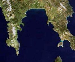
In the shape of an inverted "U", it is approximately 58 km (36 mi) wide east to west, and 44 km (27 mi) long north to south. It is bounded to the west by the
438:
452:
382:
555:
589:
480:
594:
424:
466:
584:
18:
76:
548:
494:
410:
296:
122:
579:
541:
300:
359:
574:
396:
226:
307:
but that changed when the government in 2021 extended its territorial waters 12 miles into that Gulf.
336:
60:
321:
164:
315:
264:
171:
525:
331:
310:
In June 2023 a detailed study was published by
Geollect on STS transfers by Russian vessels.
267:. The Mani and Cape Maleas peninsulas are dry and rocky, but the northern shore, fed by the
439:"Greece Tightens Grip on Laconian Gulf: Naval Exclusion Zone Disrupts Russian Oil Transfers"
358:
at the eastern end of mediterranean
Morocco, but another report had this oil originating in
326:
108:
284:
303:(STS) transfers of oil. The preferred location for STS transfers had been until then the
304:
252:
248:
217:
178:
259:
peninsula (also known as the
Epidavros Limira peninsula), which separates it from the
568:
268:
154:
513:
467:"Tankers Return to Greek Gulf to Switch Russian Oil as Drills End - BNN Bloomberg"
383:"Greek navy extends war games exclusion at notorious Russian oil transfer hotspot"
521:
272:
256:
237:
425:""Reasons Unknown": Floating Russian Oil Base off Greece Abruptly Shifts South"
271:, which empties into the gulf at its apex, is fertile farmland. The island of
453:"Russia Has a New Hotspot for Ship-to-Ship Oil Transfers in the Mediterranean"
260:
244:. It is the southernmost gulf in Greece and the largest in the Peloponnese.
346:
In early May 2024 the
Russian "base" had moved south to the western shore of
137:
124:
33:
20:
340:
495:"Floating Russian Oil Base Shifts to New Location in Mediterranean Sea"
411:"The case of LIGERA: Unveiling sanctioned Russian oil's global journey"
351:
347:
280:
279:
directly to the south. The main ports and settlements on the gulf are
276:
165:
241:
184:
355:
295:
The
Laconian Gulf gained notoriety in the early years after the
481:"Russian Oil Finds New Site for Controversial Cargo Switching"
529:
231:
202:
194:
190:
177:
163:
153:
114:
104:
53:
115:
313:In April 2024 a meticulous study followed the
275:lies in the Laconian Gulf, with the island of
549:
8:
299:because Russia used it regularly to conduct
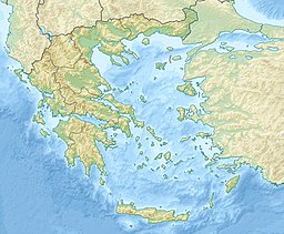
96:Location of the Laconian Gulf within Greece
556:
542:
50:
371:
377:
375:
83:
7:
510:
508:
65:Satellite image of the Laconian Gulf
397:"The Laconian Gulf and Russian Oil"
528:. You can help Knowledge (XXG) by
325:a shipment of oil from the Baltic
263:. To the south it opens onto the
236:), is a gulf in the south-eastern
206:58 km (36 mi) (min)
14:
590:Landforms of Peloponnese (region)
512:
329:, and then a shipment of oil on
297:2022 Russian invasion of Ukraine
82:
75:
59:
201:
193:
251:, which separates it from the
1:
103:
595:Peloponnese geography stubs
232:
611:
585:Gulfs of the Mediterranean
507:
255:, and to the east by the
221:
70:
58:
319:as it received from the
48:Gulf in Southeast Europe
198:44 km (27 mi)
524:location article is a
580:Landforms of Laconia
337:Port of Novorossyisk
354:, near the city of
134: /
30: /
537:
536:
265:Mediterranean Sea
230:
210:
209:
172:Mediterranean Sea
138:36.583°N 22.667°E
34:36.583°N 22.667°E
602:
558:
551:
544:
516:
509:
499:
498:
491:
485:
484:
477:
471:
470:
463:
457:
456:
449:
443:
442:
435:
429:
428:
421:
415:
414:
407:
401:
400:
393:
387:
386:
379:
327:Port of Ust-Luga
235:
233:Lakonikos Kolpos
225:
223:
222:Λακωνικός Κόλπος
167:
149:
148:
146:
145:
144:
139:
135:
132:
131:
130:
127:
117:
109:Southeast Europe
86:
85:
79:
63:
51:
45:
44:
42:
41:
40:
35:
31:
28:
27:
26:
23:
610:
609:
605:
604:
603:
601:
600:
599:
575:Gulfs of Greece
565:
564:
563:
562:
505:
503:
502:
493:
492:
488:
479:
478:
474:
465:
464:
460:
451:
450:
446:
437:
436:
432:
423:
422:
418:
409:
408:
404:
395:
394:
390:
381:
380:
373:
368:
293:
181: countries
166:Primary inflows
142:
140:
136:
133:
128:
125:
123:
121:
120:
100:
99:
98:
97:
94:
93:
92:
91:
87:
66:
49:
38:
36:
32:
29:
24:
21:
19:
17:
16:
12:
11:
5:
608:
606:
598:
597:
592:
587:
582:
577:
567:
566:
561:
560:
553:
546:
538:
535:
534:
517:
501:
500:
497:. 4 June 2024.
486:
483:. 3 June 2024.
472:
469:. 20 May 2024.
458:
444:
441:. 22 May 2024.
430:
416:
402:
399:. 6 June 2023.
388:
370:
369:
367:
364:
305:Messenian Gulf
292:
289:
253:Messenian Gulf
249:Mani peninsula
208:
207:
204:
200:
199:
196:
192:
191:
188:
187:
182:
175:
174:
169:
161:
160:
157:
151:
150:
143:36.583; 22.667
118:
112:
111:
106:
102:
101:
95:
89:
88:
81:
80:
74:
73:
72:
71:
68:
67:
64:
56:
55:
47:
39:36.583; 22.667
13:
10:
9:
6:
4:
3:
2:
607:
596:
593:
591:
588:
586:
583:
581:
578:
576:
573:
572:
570:
559:
554:
552:
547:
545:
540:
539:
533:
531:
527:
523:
518:
515:
511:
506:
496:
490:
487:
482:
476:
473:
468:
462:
459:
454:
448:
445:
440:
434:
431:
427:. 5 May 2024.
426:
420:
417:
412:
406:
403:
398:
392:
389:
385:. 9 May 2024.
384:
378:
376:
372:
365:
363:
361:
357:
353:
349:
344:
342:
338:
334:
333:
328:
324:
323:
318:
317:
311:
308:
306:
302:
298:
291:STS transfers
290:
288:
286:
282:
278:
274:
270:
269:Evrotas River
266:
262:
258:
254:
250:
245:
243:
239:
234:
228:
219:
215:
214:Laconian Gulf
205:
197:
189:
186:
183:
180:
176:
173:
170:
168:
162:
158:
156:
152:
147:
119:
113:
110:
107:
90:Laconian Gulf
78:
69:
62:
57:
54:Laconian Gulf
52:
46:
43:
530:expanding it
519:
504:
489:
475:
461:
447:
433:
419:
405:
391:
345:
330:
320:
314:
312:
309:
301:ship-to-ship
294:
246:
213:
211:
15:
522:Peloponnese
322:MV Nautilus
273:Elafonissos
257:Cape Maleas
238:Peloponnese
195:Max. length
141: /
116:Coordinates
37: /
569:Categories
366:References
261:Aegean Sea
203:Max. width
341:Black Sea
335:from the
316:MV Ligera
227:romanized
360:Primorsk
285:Neapolis
105:Location
352:Morocco
348:Kythira
339:on the
332:MV Blue
281:Gytheio
277:Kythira
229::
129:22°40′E
126:36°35′N
25:22°40′E
22:36°35′N
242:Greece
185:Greece
520:This
356:Nador
240:, in
218:Greek
179:Basin
526:stub
283:and
212:The
159:Gulf
155:Type
571::
374:^
362:.
343:.
287:.
224:,
220::
557:e
550:t
543:v
532:.
455:.
413:.
216:(
Text is available under the Creative Commons Attribution-ShareAlike License. Additional terms may apply.