456:
44:
317:, which is navigable by small boats. Lagoa Mirim has no direct connection to the Atlantic, but the Rio Grande, a tidal channel about 39 km (24 mi) long which connects Lagoon dos Patos to the Atlantic, affords an entrance to the navigable inland waters of both lagoons and several small ports. Both lagoons are the remains of an ancient depression in the coastline shut in by sand beaches built up by the combined action of
513:
578:
413:
51:
215:
308:
Lagoon Mirim is about 174 kilometres (108 mi) long by 10 to 35 km (6 to 22 mi) wide and 3,750 km (1,450 sq mi) in area. It is more irregular in outline than its larger neighbor to the north,
348:(Uruguay). On the Uruguayan side apart from the Yaguarón River, the Cebollatí River and the Tacuarí River empty into the Lagoon Mirim. The amount of water received by the lagoon is greater from the Uruguayan side.
497:
90:
666:
340:, which forms part of the Brazil-Uruguay boundary line, empties into Lagoon Mirim, and is navigable 42 km (26 mi) up to and beyond the twin towns of
627:
434:
671:
562:
362:
656:
490:
661:
425:
686:
483:
676:
620:
394:
43:
555:
646:
613:
651:
548:
314:
293:
144:
333:
137:
357:
681:
345:
233:
455:
336:
lies to the east of the lagoon, in the narrow land strip between it and the
Atlantic Ocean. The
289:
463:
367:
337:
325:. They are at the same level as the ocean, but their waters are affected by the tides and are
281:
258:
597:
532:
467:
285:
246:
322:
310:
297:
270:
151:
640:
429:
419:
122:
577:
512:
184:
3,750 km (1,450 sq mi) to 3,899.7 km (1,505.7 sq mi)
341:
105:
92:
438:. Vol. 4 (11th ed.). Cambridge University Press. pp. 439–442.
218:
17:
326:
593:
274:
266:
251:
214:
127:
76:
138:
589:
528:
524:
262:
254:
130:
72:
418:
This article incorporates text from a publication now in the
213:
585:
520:
318:
601:
536:
471:
389:
387:
385:
383:
329:only a short distance above the Rio Grande outlet.
204:
196:
188:
180:
172:
164:
160:
150:
136:
121:
82:
68:
32:
83:
621:
556:
491:
8:
156:47,756.3 km (18,438.8 sq mi)
628:
614:
563:
549:
498:
484:
29:
313:, and discharges into the latter through
379:
462:This geographical article relating to
363:1851 Boundary Treaty (Brazil–Uruguay)
358:Topography and hydrography of Uruguay
245:
232:
7:
667:International lakes of South America
574:
572:
509:
507:
452:
450:
269:. Lagoa Mirim is separated from the
50:
424:Lamoureux, Andrew Jackson (1911). "
292:empty into Lagoon Mirim, while the
600:. You can help Knowledge (XXG) by
535:. You can help Knowledge (XXG) by
470:. You can help Knowledge (XXG) by
200:23.4 km (5.6 cu mi)
176:10 to 35 km (6 to 22 mi)
25:
672:Rio Grande do Sul geography stubs
576:
511:
454:
411:
49:
42:
203:
195:
187:
179:
171:
163:
657:Landforms of Rio Grande do Sul
1:
273:by a sandy, partially barren
67:
257:which extends from southern
168:174 kilometres (108 mi)
368:Jaguarão River#Navigability
27:Lagoon in Rio Grande do Sul
703:
584:This article related to a
571:
519:This article related to a
506:
449:
37:
687:Uruguay geography stubs
435:Encyclopædia Britannica
395:"Atlantic East Coastal"
338:Jaguarão/Yaguarón River
334:Taim Ecological Station
677:Brazil geography stubs
222:
662:Brazil–Uruguay border
217:
192:6 m (20 ft)
208:0 m (0 ft)
315:São Gonçalo Channel
294:São Gonçalo Channel
145:São Gonçalo Channel
102: /
223:
647:Lagoons of Brazil
609:
608:
544:
543:
479:
478:
464:Rio Grande do Sul
296:connects it with
282:Jaguarão/Yaguarón
259:Rio Grande do Sul
212:
211:
205:Surface elevation
106:32.750°S 52.833°W
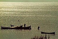
16:(Redirected from
694:
652:Lakes of Uruguay
630:
623:
616:
580:
573:
565:
558:
551:
515:
508:
500:
493:
486:
458:
451:
439:
417:
415:
414:
399:
398:
391:
323:oceanic currents
290:Cebollatí Rivers
249:
247:[meˈɾin]
244:
236:
231:
140:
139:Primary outflows
117:
116:
114:
113:
112:
111:-32.750; -52.833
107:
103:
100:
99:
98:
95:
85:
53:
52:
46:
30:
21:
702:
701:
697:
696:
695:
693:
692:
691:
637:
636:
635:
634:
570:
569:
505:
504:
447:
445:
423:
412:
410:
408:
403:
402:
393:
392:
381:
376:
354:
311:Lagoa dos Patos
306:
298:Lagoa dos Patos
242:
234:[miˈɾĩ]
229:
221:at Lagoon Mirim
110:
108:
104:
101:
96:
93:
91:
89:
88:
64:
63:
62:
61:
60:
59:
58:
54:
28:
23:
22:
15:
12:
11:
5:
700:
698:
690:
689:
684:
679:
674:
669:
664:
659:
654:
649:
639:
638:
633:
632:
625:
618:
610:
607:
606:
581:
568:
567:
560:
553:
545:
542:
541:
516:
503:
502:
495:
488:
480:
477:
476:
459:
444:
443:External links
441:
430:Chisholm, Hugh
407:
404:
401:
400:
378:
377:
375:
372:
371:
370:
365:
360:
353:
350:
305:
302:
300:to the north.
271:Atlantic Ocean
210:
209:
206:
202:
201:
198:
194:
193:
190:
186:
185:
182:
178:
177:
174:
170:
169:
166:
162:
161:
158:
157:
154:
152:Catchment area
148:
147:
142:
134:
133:
125:
119:
118:
86:
80:
79:
70:
66:
65:
56:
55:
48:
47:
41:
40:
39:
38:
35:
34:
26:
24:
14:
13:
10:
9:
6:
4:
3:
2:
699:
688:
685:
683:
680:
678:
675:
673:
670:
668:
665:
663:
660:
658:
655:
653:
650:
648:
645:
644:
642:
631:
626:
624:
619:
617:
612:
611:
605:
603:
599:
595:
591:
587:
582:
579:
575:
566:
561:
559:
554:
552:
547:
546:
540:
538:
534:
530:
526:
522:
517:
514:
510:
501:
496:
494:
489:
487:
482:
481:
475:
473:
469:
465:
460:
457:
453:
448:
442:
440:
437:
436:
431:
427:
421:
420:public domain
405:
396:
390:
388:
386:
384:
380:
373:
369:
366:
364:
361:
359:
356:
355:
351:
349:
347:
344:(Brazil) and
343:
339:
335:
330:
328:
324:
320:
316:
312:
303:
301:
299:
295:
291:
287:
283:
278:
276:
272:
268:
265:into eastern
264:
260:
256:
253:
250:) is a large
248:
240:
235:
228:(Portuguese,
227:
220:
216:
207:
199:
191:
189:Average depth
183:
175:
167:
159:
155:
153:
149:
146:
143:
141:
135:
132:
129:
126:
124:
120:
115:
87:
81:
78:
74:
71:
45:
36:
31:
19:
602:expanding it
583:
537:expanding it
518:
472:expanding it
461:
446:
433:
409:
331:
307:
279:
238:
226:Lagoon Mirim
225:
224:
197:Water volume
181:Surface area
57:Lagoon Mirim
33:Lagoon Mirim
165:Max. length
109: /
84:Coordinates
18:Lagoa Mirim
682:Lake stubs
641:Categories
374:References
346:Rio Branco
243:pronounced
241:(Spanish,
230:pronounced
173:Max. width
261:state in
252:estuarine
219:Fishermen
128:estuarine
352:See also
342:Jaguarão
327:brackish
304:Location
69:Location
594:Uruguay
432:(ed.).
422::
406:Sources
286:Tacuarí
275:isthmus
267:Uruguay
97:52°50′W
94:32°45′S
77:Uruguay
590:lagoon
529:Brazil
525:lagoon
428:". In
426:Brazil
416:
263:Brazil
255:lagoon
131:lagoon
73:Brazil
596:is a
531:is a
466:is a
239:Merín
237:) or
598:stub
586:lake
533:stub
521:lake
468:stub
332:The
321:and
319:wind
288:and
280:The
123:Type
75:and
592:in
588:or
527:in
523:or
643::
382:^
284:,
277:.
629:e
622:t
615:v
604:.
564:e
557:t
550:v
539:.
499:e
492:t
485:v
474:.
397:.
20:)
Text is available under the Creative Commons Attribution-ShareAlike License. Additional terms may apply.