61:
80:
87:
309:
There are periods of low rainfall in March and
September–October, and periods of high rainfall in July and December. The annual rainfall in the region is about 287 centimetres (113 in), being higher in the southeast part of the lagoon. February is the windiest month in the lagoon.
403:
652:
123:
482:
79:
544:
Report on a
Reconnaissance Survey to Establish the Possibilities of a Pulp and Paper Industry in the Bocas Del Toro Province of Panama
657:
60:
647:
526:
436:
287:
is 0.24 metres (9.4 in) with a maximum range of 0.64 metres (2 ft 1 in); tidal flow in the lagoon is weak.
306:, which covers 240.89 square kilometres (93.01 sq mi) of land between the lagoon and the Caribbean coast.
298:, both of which flow through the wetlands on the southeast shore of the lagoon. These are protected as part of the
261:
321:
continue to inhabit the southern and eastern coasts of the lagoon. The lagoon is administratively divided between
326:
642:
322:
588:
279:
The temperature of the water in the lagoon ranges from 26 to 28 °C. Salinity can be as low as 1.015 (
27:
This article is about the lagoon on Panama's
Caribbean coast. For the gulf on Panama's Pacific coast, see
337:
253:
173:
303:
483:"A Site Description of the CARICOMP Mangrove, Seagrass and Coral Reef Sites in Bocas del Toro, Panama"
314:
273:
28:
155:
333:
248:
covering an area of about 900 square kilometres (350 sq mi). It is separated from the
221:
522:
432:
426:
611:
376:
291:
280:
265:
162:
50:
481:
Guzmán, Héctor M.; Barnes, Penelope A. G.; Lovelock, Catherine E.; Feller, Ilka C. (2005).
612:"Contingency Planning and Operations in the Event of a Hydrocarbon Spill in the Caribbean"
295:
166:
191:
380:
636:
317:
into the lagoon in 1502 during his search for a connection to the
Pacific Ocean. The
257:
249:
184:
180:
225:
65:
565:
276:
in the northeast, which is the main access channel for ships entering the lagoon.
17:
543:
516:
299:
284:
459:
332:
Coal deposits were discovered in the area in the mid-19th century. The port of
345:
138:
125:
341:
269:
283:) due to runoff from rivers, especially during the rainy season. The mean
318:
229:
156:
174:
245:
241:
109:
574:
367:
Herdendorf, Charles E. (1982). "Large Lakes of the World".
428:
Geomorphology of
Central America: A Syngenetic Perspective
567:
Earth and Water
Resources and Hazards in Central America
460:"Humedal de Importancia Internacional Damani-Guariviara"
272:. The widest and deepest entrance into the bay is the
290:Rivers that drain into Chiriquí Lagoon include the
217:
213:
205:
201:
190:
172:
154:
115:
104:
36:
462:. Ramsar Sites Information Service. 9 March 2010
116:
68:, a town on the western coast of Chiriquí Lagoon
348:of oil on to the surrounding land and water.
42:
8:
542:Holdridge, L. R.; Budowski, Gerardo (1958).
362:
360:
515:Brinkbäumer, Klaus; Höges, Clemens (2007).
406:. Petroterminal de Panamá. 14 October 2014
33:
404:"Chiriquí Grande port information manual"
398:
396:
394:
392:
390:
356:
86:
653:Panamanian coasts of the Caribbean Sea
7:
610:Sagrera, Carlos (March–April 2008).
344:on 4 February 2007 that leaked 5030
573:. Geological Survey Circular 925.
340:. The terminal was the site of an
25:
209:900 km (350 sq mi)
336:is the northern terminus of the
85:
78:
59:
425:Bergoeing, Jean Pierre (2007).
369:Journal of Great Lakes Research
204:
1:
381:10.1016/S0380-1330(82)71982-3
103:
490:Caribbean Journal of Science
264:to the northwest, including
674:
518:The Voyage of the Vizcaína
262:Bocas del Toro Archipelago
244:on the northwest coast of
26:
591:. Petroterminal de Panama
521:. Harcourt. p. 214.
431:. Elsevier. p. 127.
73:
58:
41:
618:. Panama. pp. 49–50
313:Native Americans guided
658:Bocas del Toro Province
323:Bocas del Toro Province
546:(Report). pp. 3–4
43:
648:Bays of the Caribbean
338:Trans-Panama pipeline
256:to the east and from
315:Christopher Columbus
589:"Atlantic terminal"
577:. 1984. p. 31.
327:Ngäbe-Buglé Comarca
135: /
260:by islands in the
254:Valiente Peninsula
44:Laguna de Chiriquí
18:Laguna de Chiriquí
304:Damani-Guariviara
235:
234:
16:(Redirected from
665:
628:
627:
625:
623:
607:
601:
600:
598:
596:
585:
579:
578:
572:
562:
556:
555:
553:
551:
539:
533:
532:
512:
506:
505:
503:
501:
487:
478:
472:
471:
469:
467:
456:
450:
449:
447:
445:
422:
416:
415:
413:
411:
400:
385:
384:
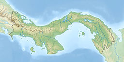
364:
325:in the west and
292:Guariviara River
176:
175:Primary outflows
163:Guariviara River
158:
150:
149:
147:
146:
145:
140:
136:
133:
132:
131:
128:
118:
89:
88:
82:
63:
54:
46:
34:
29:Gulf of Chiriquí
21:
673:
672:
668:
667:
666:
664:
663:
662:
633:
632:
631:
621:
619:
609:
608:
604:
594:
592:
587:
586:
582:
570:
564:
563:
559:
549:
547:
541:
540:
536:
529:
514:
513:
509:
499:
497:
485:
480:
479:
475:
465:
463:
458:
457:
453:
443:
441:
439:
424:
423:
419:
409:
407:
402:
401:
388:
366:
365:
358:
354:
334:Chiriquí Grande
296:Cricamola River
274:Canal del Tigre
238:Chiriquí Lagoon
222:Chiriquí Grande
194: countries
167:Cricamola River
157:Primary inflows
143:
141:
137:
134:
129:
126:
124:
122:
121:
100:
99:
98:
97:
96:
95:
94:
93:Chiriquí Lagoon
90:
69:
48:
37:Chiriquí Lagoon
32:
23:
22:
15:
12:
11:
5:
671:
669:
661:
660:
655:
650:
645:
643:Bays of Panama
635:
634:
630:
629:
602:
580:
557:
534:
527:
507:
473:
451:
437:
417:
386:
375:(3): 379–412.
355:
353:
350:
233:
232:
219:
215:
214:
211:
210:
207:
203:
202:
199:
198:
195:
188:
187:
178:
170:
169:
160:
152:
151:
119:
113:
112:
106:
102:
101:
92:
91:
84:
83:
77:
76:
75:
74:
71:
70:
64:
56:
55:
39:
38:
24:
14:
13:
10:
9:
6:
4:
3:
2:
670:
659:
656:
654:
651:
649:
646:
644:
641:
640:
638:
617:
613:
606:
603:
590:
584:
581:
576:
569:
568:
561:
558:
545:
538:
535:
530:
524:
520:
519:
511:
508:
495:
491:
484:
477:
474:
461:
455:
452:
440:
434:
430:
429:
421:
418:
405:
399:
397:
395:
393:
391:
387:
382:
378:
374:
370:
363:
361:
357:
351:
349:
347:
343:
339:
335:
330:
329:in the east.
328:
324:
320:
316:
311:
307:
305:
301:
297:
293:
288:
286:
282:
277:
275:
271:
267:
263:
259:
258:Almirante Bay
255:
251:
250:Caribbean Sea
247:
243:
239:
231:
227:
223:
220:
216:
212:
208:
200:
196:
193:
189:
186:
185:Almirante Bay
182:
181:Caribbean Sea
179:
177:
171:
168:
164:
161:
159:
153:
148:
120:
114:
111:
107:
81:
72:
67:
62:
57:
52:
45:
40:
35:
30:
19:
620:. Retrieved
615:
605:
593:. Retrieved
583:
566:
560:
548:. Retrieved
537:
517:
510:
498:. Retrieved
496:(3): 430–440
493:
489:
476:
464:. Retrieved
454:
442:. Retrieved
427:
420:
408:. Retrieved
372:
368:
331:
312:
308:
289:
278:
237:
236:
226:Punta Robalo
206:Surface area
66:Punta Robalo
300:Ramsar site
285:tidal range
240:is a large
218:Settlements
142: /
117:Coordinates
637:Categories
616:Transports
528:0156031582
438:0128031859
352:References
108:northwest
342:oil spill
270:Isla Popa
266:Cayo Agua
622:24 April
595:24 April
550:24 April
500:24 April
466:24 April
444:24 April
410:24 April
230:Cauchero
139:9°N 82°W
105:Location
346:barrels
252:by the
51:Spanish
525:
435:
246:Panama
242:lagoon
197:Panama
144:9; -82
110:Panama
47:
571:(PDF)
486:(PDF)
319:Ngäbe
192:Basin
624:2017
597:2017
575:USGS
552:2017
523:ISBN
502:2017
468:2017
446:2017
433:ISBN
412:2017
294:and
268:and
130:82°W
377:doi
302:of
127:9°N
639::
614:.
494:41
492:.
488:.
389:^
371:.
359:^
281:SG
228:,
224:,
183:,
165:,
626:.
599:.
554:.
531:.
504:.
470:.
448:.
414:.
383:.
379::
373:8
53:)
49:(
31:.
20:)
Text is available under the Creative Commons Attribution-ShareAlike License. Additional terms may apply.