50:
357:
57:
37:
234:
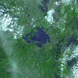
Olomega is the eastern region of El
Salvador's, largest freshwater body. The site also includes the surrounding vegetation, such as herbaceous swamps and a patch of forest seasonally saturated, known as the Chiriqui and one of the last relics of this type of community in El Salvador
255:
Olomega can be reached either by taking a bus directly to the town, although the bus to
Olomega does not run often, or by getting off at El Carmen (the pueblo, just off the highway) and waiting for a truck to go to Olomega. tambien puedes entrar por el lado de puerto viejo
230:
For years this natural resource has received the black waters of the settlements to their round, pollution by livestock and fisheries hasn't been unregulated. With Ramsar status, the
Government can make sustainable development in the area, thanks to international support.
226:
Lake
Olomega is located next to the town of Olomega (population 4000). The community relies heavily on fishing and ecotourism. The canton Los Riitos has geothermal water and can most easily be reached by boat (as long as the nimfa does not prevent boat travel).
244:
An electronic report of the Ramsar
Convention details show that the lagoon is home to several endangered species, such as the royal duck, dark ibis, the snail and the tree frog.
326:
238:
The hydrological features of the site include flood control, water purification, and the replenishment of groundwater, serving for more than 9,000 inhabitants of the area.
398:
90:
49:
427:
422:
330:
391:
417:
384:
129:
247:
This wetland, which measures 7,557 hectares, serves as the resting and feeding ground for many migratory birds.
313:
213:
122:
278:
164:
368:
220:
136:
411:
300:
Marshall, Joe T. Jr. "Additional
Information concerning the Birds of El Salvador"
17:
364:
356:
105:
92:
36:
219:
In the past few years Lake
Olomega has suffered from an infestation of
123:
273:
209:
223:
which has caused problems for wildlife, fishing, and tourism.
372:
187:
179:
171:
162:
158:
150:
146:
135:
121:
82:
74:
29:
304:, Vol. 45, No. 1. (Jan. - Feb., 1943), pp. 21-33.
83:
392:
8:
399:
385:
26:
265:
186:
178:
170:
161:
7:
353:
351:
327:"Ramsar Convention - Briefing Notes"
56:
371:. You can help Knowledge (XXG) by
154:24.2 km (9.3 sq mi)
25:
355:
55:
48:
35:
149:
1:
73:
212:in the southeastern part of
428:El Salvador geography stubs
423:Ramsar sites in El Salvador
444:
350:
281:Sites Information Service
199:
195:
78:South-Eastern El Salvador
43:
34:
130:Río Grande de San Miguel
316:accessed June 12, 2007.
367:location article is a
418:Lakes of El Salvador
274:"Laguna de Olomega"
102: /
241:Rich biodiversity
188:Reference no.
380:
379:
203:
202:
175:Laguna de Olomega
106:13.317°N 88.067°W
18:Laguna de Olomega
16:(Redirected from
435:
401:
394:
387:
359:
352:
342:
341:
339:
338:
329:. Archived from
323:
317:
311:
305:
298:
292:
291:
289:
287:
270:
125:
117:
116:
114:
113:
112:
107:
103:
100:
99:
98:
95:
85:
59:
58:
52:
39:
27:
21:
443:
442:
438:
437:
436:
434:
433:
432:
408:
407:
406:
405:
348:
346:
345:
336:
334:
325:
324:
320:
312:
308:
299:
295:
285:
283:
272:
271:
267:
262:
253:
183:2 February 2010
167:
139: countries
124:Primary inflows
111:13.317; -88.067
110:
108:
104:
101:
96:
93:
91:
89:
88:
70:
69:
68:
67:
66:
65:
64:
60:
23:
22:
15:
12:
11:
5:
441:
439:
431:
430:
425:
420:
410:
409:
404:
403:
396:
389:
381:
378:
377:
360:
344:
343:
318:
306:
293:
264:
263:
261:
258:
252:
251:Transportation
249:
221:Water hyacinth
201:
200:
197:
196:
193:
192:
189:
185:
184:
181:
177:
176:
173:
169:
168:
165:Ramsar Wetland
163:
160:
159:
156:
155:
152:
148:
147:
144:
143:
140:
133:
132:
127:
119:
118:
86:
80:
79:
76:
72:
71:
62:
61:
54:
53:
47:
46:
45:
44:
41:
40:
32:
31:
24:
14:
13:
10:
9:
6:
4:
3:
2:
440:
429:
426:
424:
421:
419:
416:
415:
413:
402:
397:
395:
390:
388:
383:
382:
376:
374:
370:
366:
361:
358:
354:
349:
333:on 2013-04-15
332:
328:
322:
319:
315:
310:
307:
303:
297:
294:
282:
280:
275:
269:
266:
259:
257:
250:
248:
245:
242:
239:
236:
232:
228:
224:
222:
217:
215:
211:
207:
198:
194:
190:
182:
174:
172:Official name
166:
157:
153:
145:
141:
138:
134:
131:
128:
126:
120:
115:
87:
81:
77:
51:
42:
38:
33:
28:
19:
373:expanding it
362:
347:
335:. Retrieved
331:the original
321:
309:
301:
296:
284:. Retrieved
277:
268:
254:
246:
243:
240:
237:
233:
229:
225:
218:
206:Lake Olomega
205:
204:
151:Surface area
63:Lake Olomega
30:Lake Olomega
365:El Salvador
214:El Salvador
208:is a large
142:El Salvador
109: /
84:Coordinates
412:Categories
337:2013-03-09
302:The Condor
260:References
180:Designated
314:NASA.gov
286:25 April
75:Location
97:88°04′W
94:13°19′N
279:Ramsar
363:This
137:Basin
369:stub
288:2018
210:lake
191:1899
414::
276:.
216:.
400:e
393:t
386:v
375:.
340:.
290:.
20:)
Text is available under the Creative Commons Attribution-ShareAlike License. Additional terms may apply.