141:
363:
154:
30:
161:
37:
441:
407:
446:
140:
72:
431:
333:
Recursos Hídricos del Perú en Cifras, Boletín Técnico de
Recursos Hídricos 2010, Autoridad Nacional del Agua, Ministerio de Agricultura, Peru
400:
250:
393:
153:
29:
272:
The
Choclococha dam was completed in 1960. It is 280 m (920 ft) long and 12 m (13 yd) tall. The
262:
276:
has a volume of 66,000 m (54 acre⋅ft) and a capacity of 17,000,000 m (14,000 acre⋅ft).
246:
426:
436:
285:
254:
370:
362:
258:
238:
58:
306:
377:
224:
308:
Diccionario Bilingüe: Iskay simipi yuyayk’anch: Quechua – Castellano / Castellano – Quechua
351:
104:
420:
324:
escale.minedu.gob.pe - UGEL map of the
Castrovirreyna Province (Huancavelica Region)
87:
74:
373:
273:
266:
230:
242:
381:
210:
205:
197:
189:
184:
176:
133:
118:
114:
103:
64:
54:
18:
65:
442:Buildings and structures in Huancavelica Region
401:
237:lake, "corncob lake") is a large lake in the
8:
314:. La Paz, Bolivia: futatraw.ourproject.org.
408:
394:
139:
130:
15:
341:INEI, Compendio Estadistica 2007, page 26
261:. Choclococha lies east of a lake named
160:
297:
214:17,000,000 m (14,000 acre⋅ft)
7:
359:
357:
447:Huancavelica Region geography stubs
36:
380:. You can help Knowledge (XXG) by
14:
361:
159:
152:
35:
28:
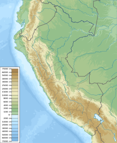
168:Location of Choclococha in Peru
117:
305:Teofilo Laime Ajacopa (2007).
1:
53:
432:Lakes of Huancavelica Region
463:
356:
147:
138:
23:
245:. It is situated in the
201:280 m (920 ft)
247:Castrovirreyna Province
193:12 m (39 ft)
286:List of lakes in Peru
88:13.16667°S 75.06667°W
93:-13.16667; -75.06667
371:Huancavelica Region
259:Pilpichaca District
239:Huancavelica Region
211:Total capacity
122:4,521 m (14,833 ft)
84: /
59:Huancavelica Region
251:Santa Ana District
389:
388:
255:Huaytará Province
218:
217:
185:Dam and spillways
126:
125:
119:Surface elevation
454:
410:
403:
396:
365:
358:
334:
331:
325:
322:
316:
315:
313:
302:
163:
162:
156:
143:
131:
99:
98:
96:
95:
94:
89:
85:
82:
81:
80:
77:
67:
39:
38:
32:
16:
462:
461:
457:
456:
455:
453:
452:
451:
417:
416:
415:
414:
348:
338:
337:
332:
328:
323:
319:
311:
304:
303:
299:
294:
282:
223:(possibly from
172:
171:
170:
169:
166:
165:
164:
129:
107: countries
92:
90:
86:
83:
78:
75:
73:
71:
70:
50:
49:
48:
47:
46:
45:
44:
40:
12:
11:
5:
460:
458:
450:
449:
444:
439:
434:
429:
419:
418:
413:
412:
405:
398:
390:
387:
386:
366:
355:
354:
347:
346:External links
344:
343:
342:
336:
335:
326:
317:
296:
295:
293:
290:
289:
288:
281:
278:
216:
215:
212:
208:
207:
203:
202:
199:
195:
194:
191:
187:
186:
182:
181:
178:
174:
173:
167:
158:
157:
151:
150:
149:
148:
145:
144:
136:
135:
127:
124:
123:
120:
116:
115:
112:
111:
108:
101:
100:
68:
62:
61:
56:
52:
51:
42:
41:
34:
33:
27:
26:
25:
24:
21:
20:
13:
10:
9:
6:
4:
3:
2:
459:
448:
445:
443:
440:
438:
435:
433:
430:
428:
427:Lakes of Peru
425:
424:
422:
411:
406:
404:
399:
397:
392:
391:
385:
383:
379:
376:article is a
375:
372:
367:
364:
360:
353:
350:
349:
345:
340:
339:
330:
327:
321:
318:
310:
309:
301:
298:
291:
287:
284:
283:
279:
277:
275:
270:
268:
265:and north of
264:
260:
256:
252:
248:
244:
240:
236:
232:
229:
226:
222:
213:
209:
204:
200:
196:
192:
188:
183:
179:
175:
155:
146:
142:
137:
132:
121:
113:
109:
106:
102:
97:
69:
63:
60:
57:
31:
22:
17:
437:Dams in Peru
382:expanding it
368:
352:Flickr image
329:
320:
307:
300:
271:
234:
227:
220:
219:
253:and in the
221:Choclococha
134:Choclococha
91: /
66:Coordinates
43:Choclococha
19:Choclococha
421:Categories
292:References
374:geography
274:reservoir
267:Caracocha
263:Orcococha
206:Reservoir
76:13°10′0″S
280:See also
79:75°4′0″W
55:Location
231:corncob
228:chuqllu
225:Quechua
177:Country
198:Length
190:Height
369:This
312:(PDF)
235:qucha
105:Basin
378:stub
243:Peru
180:Peru
110:Peru
241:of
128:Dam
423::
269:.
257:,
249:,
233:,
409:e
402:t
395:v
384:.
Text is available under the Creative Commons Attribution-ShareAlike License. Additional terms may apply.