29:
48:
55:
502:
Named tributaries of Lake Creek from source to mouth are Billy Tower Canyon followed by
Congdon, Swartz, Village, Conrad, Pope, Post, and Swamp creeks. Then come Pontiss, Little Lake, Spring Canyon, Fish, Lamb, and Greenleaf creeks. Further downstream are Steinhauer, Wheeler, Nelson, Wilcut, Hollo,
441:
The BLM also manages a site at Hult
Reservoir, also known as Hult Pond, along Lake Creek upstream of Horton. Possible activities include picnicking, boating, and warm-water fishing. Amenities include a boat launch and toilets. Nearby is the Hult Equestrian Staging Area for horse riding on trails.
458:, depending on location and flow rates. Hazards include rapids called "The Horn" and "Bus Stop" with large waves and rocks. Along the river below the confluence with the creek, a sometimes-submerged human-made structure poses danger to boaters.
47:
418:
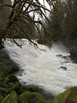
oversees the Lake Creek Falls recreation site downstream of
Triangle Lake. Open all year, the site is used for picnicking, swimming, and viewing runs of
231:
28:
455:
397:
or Nelson
Mountain Bridge carries Nelson Mountain Road over the creek. Nelson Road meets Route 36 just north of the bridge. The bridge is on the
779:
154:
626:
581:
398:
545:
649:
753:
494:, which also frequent the creek, is prohibited. Other regulations may apply depending on species, season, and location.
343:
136:
784:
486:
steelhead can be kept. Fishing for
Chinook is allowed below Deadwood Creek. Cutthroat fishing is legal along the
415:
335:. On average, the 40-mile (64 km) long creek contributes about a third of the lower Siuslaw's water volume.
675:
516:
454:
on the
Siuslaw River. Various parts of the run are rated from class I (novice) to class IV (advanced) on the
504:
347:
140:
359:
339:
34:
540:
450:
Whitewater enthusiasts sometimes run an 8-mile (13 km) stretch between
Deadwood on Lake Creek and
722:
700:
438:
at this site in 1989; it opened 110 miles (180 km) additional stream-miles to migrating fish.
324:
107:
749:
622:
577:
479:
394:
371:
363:
217:
375:
367:
475:
431:
386:
355:
374:, 29 miles (47 km) by water from the larger stream's mouth on the Pacific Ocean at
471:
427:
390:
351:
773:
467:
419:
320:
205:
87:
597:
478:
that can be legally caught under certain conditions. Fishing for wild steelhead is
451:
748:(10th ed.). Scappoose, Oregon: Flying Pencil Publications. pp. 17–18.
491:
435:
423:
200:
328:
246:
233:
169:
156:
487:
483:
662:
The map includes mile markers along Lake Creek and the
Siuslaw River.
332:
97:
389:
runs along the creek from
Blachly to Swisshome. Near Greenleaf, a
576:(4th ed.). Seattle: The Mountaineers Books. pp. 64−65.
54:
621:. Corvallis: Oregon State University Press. p. 100.
572:
Giordano, Pete; Willamette Kayak and Canoe Club (2004).
746:
Fishing in Oregon: The
Complete Oregon Fishing Guide
574:
Soggy Sneakers: A Paddler's Guide to Oregon's Rivers
550:. United States Geological Survey. November 28, 1980
346:, Lake Creek flows generally southeast through the
300:
292:
280:
272:
262:
223:
211:
199:
185:
146:
130:
122:
113:
103:
93:
83:
78:
70:
21:
338:Beginning near Prairie Mountain near the Lane–
676:"Lake Creek (Nelson Mountain) Covered Bridge"
62:Location of the mouth of Lake Creek in Oregon
8:
354:, then southwest through the communities of
644:
642:
640:
638:
612:
610:
608:
606:
567:
565:
527:
456:International Scale of River Difficulty
670:
668:
535:
533:
531:
18:
681:. Oregon Department of Transportation
600:search using GNIS source coordinates.
490:but not the tributaries. Fishing for
306:706 cu ft/s (20.0 m/s)
7:
399:National Register of Historic Places
546:Geographic Names Information System
466:Lake Creek supports populations of
430:salmon as they travel upstream to
14:
652:. United States Geological Survey
370:. It enters the Siuslaw River at
284:223 sq mi (580 km)
53:
46:
27:
650:"United States Topographic Map"
596:Source elevation derived from
225: • coordinates
148: • coordinates
16:River in Oregon, United States
1:
780:Rivers of Lane County, Oregon
114:Physical characteristics
619:Field Guide to Oregon Rivers
319:is a major tributary of the
264: • elevation
187: • elevation
744:Sheehan, Madelynne Diness.
725:. Bureau of Land Management
703:. Bureau of Land Management
213: • location
132: • location
801:
344:Central Oregon Coast Range
302: • average
191:2,752 ft (839 m)
137:Central Oregon Coast Range
416:Bureau of Land Management
310:
288:
195:
118:
41:
26:
660:– via Acme Mapper.
517:List of rivers of Oregon
348:Siuslaw National Forest
276:40 mi (64 km)
268:112 ft (34 m)
141:Siuslaw National Forest
482:, but some finclipped
247:44.05528°N 123.79639°W
170:44.27861°N 123.57167°W
33:Lake Creek Falls near
507:, and Indian creeks.
342:county border in the
126:near Prairie Mountain
617:Palmer, Tim (2014).
252:44.05528; -123.79639
175:44.27861; -123.57167
350:to the vicinity of
243: /
166: /
701:"Lake Creek Falls"
446:Whitewater boating
434:. The BLM added a
628:978-0-87071-627-0
583:978-0-89886-815-9
480:catch and release
395:Lake Creek Bridge
314:
313:
74:For Triangle Lake
792:
785:Rivers of Oregon
760:
759:
741:
735:
734:
732:
730:
723:"Hult Reservoir"
719:
713:
712:
710:
708:
697:
691:
690:
688:
686:
680:
672:
663:
661:
659:
657:
646:
633:
632:
614:
601:
594:
588:
587:
569:
560:
559:
557:
555:
537:
303:
258:
257:
255:
254:
253:
248:
244:
241:
240:
239:
236:
188:
181:
180:
178:
177:
176:
171:
167:
164:
163:
162:
159:
149:
133:
57:
56:
50:
31:
19:
800:
799:
795:
794:
793:
791:
790:
789:
770:
769:
768:
763:
756:
743:
742:
738:
728:
726:
721:
720:
716:
706:
704:
699:
698:
694:
684:
682:
678:
674:
673:
666:
655:
653:
648:
647:
636:
629:
616:
615:
604:
595:
591:
584:
571:
570:
563:
553:
551:
539:
538:
529:
525:
513:
500:
476:cutthroat trout
464:
448:
412:
407:
387:Oregon Route 36
384:
301:
265:
251:
249:
245:
242:
237:
234:
232:
230:
229:
226:
214:
186:
174:
172:
168:
165:
160:
157:
155:
153:
152:
147:
131:
66:
65:
64:
63:
60:
59:
58:
37:
17:
12:
11:
5:
798:
796:
788:
787:
782:
772:
771:
767:
766:External links
764:
762:
761:
754:
736:
714:
692:
664:
634:
627:
602:
589:
582:
561:
526:
524:
521:
520:
519:
512:
509:
499:
496:
472:Chinook salmon
463:
460:
447:
444:
411:
408:
406:
403:
391:covered bridge
383:
382:Transportation
380:
312:
311:
308:
307:
304:
298:
297:
294:
290:
289:
286:
285:
282:
278:
277:
274:
270:
269:
266:
263:
260:
259:
227:
224:
221:
220:
215:
212:
209:
208:
203:
197:
196:
193:
192:
189:
183:
182:
150:
144:
143:
134:
128:
127:
124:
120:
119:
116:
115:
111:
110:
105:
101:
100:
95:
91:
90:
85:
81:
80:
76:
75:
72:
68:
67:
61:
52:
51:
45:
44:
43:
42:
39:
38:
32:
24:
23:
15:
13:
10:
9:
6:
4:
3:
2:
797:
786:
783:
781:
778:
777:
775:
765:
757:
755:0-916473-15-5
751:
747:
740:
737:
724:
718:
715:
702:
696:
693:
677:
671:
669:
665:
651:
645:
643:
641:
639:
635:
630:
624:
620:
613:
611:
609:
607:
603:
599:
593:
590:
585:
579:
575:
568:
566:
562:
549:
547:
542:
536:
534:
532:
528:
522:
518:
515:
514:
510:
508:
506:
497:
495:
493:
489:
485:
481:
477:
473:
469:
461:
459:
457:
453:
445:
443:
439:
437:
433:
429:
425:
421:
417:
409:
404:
402:
400:
396:
392:
388:
381:
379:
377:
373:
369:
365:
361:
360:Triangle Lake
357:
353:
349:
345:
341:
336:
334:
330:
326:
322:
321:Siuslaw River
318:
309:
305:
299:
295:
291:
287:
283:
279:
275:
271:
267:
261:
256:
228:
222:
219:
216:
210:
207:
206:Siuslaw River
204:
202:
198:
194:
190:
184:
179:
151:
145:
142:
138:
135:
129:
125:
121:
117:
112:
109:
106:
102:
99:
96:
92:
89:
88:United States
86:
82:
77:
73:
69:
49:
40:
36:
35:Triangle Lake
30:
25:
20:
745:
739:
727:. Retrieved
717:
705:. Retrieved
695:
683:. Retrieved
654:. Retrieved
618:
598:Google Earth
592:
573:
552:. Retrieved
544:
541:"Lake Creek"
501:
465:
449:
440:
413:
385:
337:
316:
315:
729:February 9,
707:February 9,
685:February 8,
656:February 6,
554:February 6,
498:Tributaries
492:coho salmon
436:fish ladder
325:Lane County
250: /
238:123°47′47″W
173: /
161:123°34′18″W
774:Categories
523:References
503:Johnston,
410:Picnicking
405:Recreation
329:U.S. state
317:Lake Creek
281:Basin size
235:44°03′19″N
158:44°16′43″N
22:Lake Creek
488:main stem
468:steelhead
420:steelhead
393:known as
372:Swisshome
364:Greenleaf
293:Discharge
218:Swisshome
71:Etymology
511:See also
505:Deadwood
484:hatchery
376:Florence
368:Deadwood
79:Location
462:Fishing
428:Chinook
356:Blachly
327:in the
84:Country
752:
625:
580:
548:(GNIS)
474:, and
366:, and
352:Horton
340:Benton
333:Oregon
296:
273:Length
123:Source
104:County
98:Oregon
679:(PDF)
432:spawn
201:Mouth
94:State
750:ISBN
731:2016
709:2016
687:2016
658:2016
623:ISBN
578:ISBN
556:2016
452:Tide
426:and
424:coho
422:and
414:The
108:Lane
331:of
323:in
776::
667:^
637:^
605:^
564:^
543:.
530:^
470:,
401:.
378:.
362:,
358:,
139:,
758:.
733:.
711:.
689:.
631:.
586:.
558:.
Text is available under the Creative Commons Attribution-ShareAlike License. Additional terms may apply.