43:
73:
29:
80:
50:
281:
While the
Napoleon Channel enabled river traffic to follow a more direct route, the river's new course caused its waters to flow close to the town of Napoleon, then the seat of Desha County. High waters in 1868 and 1874 destroyed and permanently submerged part of the town, and by 1882, it was no
127:
268:
ordered a channel dug across the peninsula. The soft land and strong river current enabled the "Napoleon
Channel" to be cut in one day, and in April 1863, Selfridge piloted the
240:
Duckweed is the predominant aquatic vegetation, and fish include bowfin, bream, buffalo, channel catfish, common carp, crappie, drum, green sunfish, gar and largemouth bass.
389:
394:
302:
42:
399:
72:
374:
264:
ships. The same cannon could be used on ships as they entered, and then left the tight bend. To avoid this ambush point, Union commander
309:
379:
223:
105:
384:
335:
252:
curved east and flowed around the 10 mi (16 km) "Beulah Bend". During the Civil War, soldiers of the
278:
Cut off from the main flow of the
Mississippi River, the ends of Beulah Bend filled in, forming an oxbow lake.
350:
265:
253:
227:
109:
188:
269:
234:
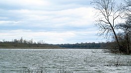
230:, United States. The Arkansas-Mississippi border follows the center of the narrow, curving lake.
257:
249:
28:
171:
368:
177:
113:
260:, and hide in the wooded area west of Beulah Bend, where they would fire at passing
261:
219:
164:
142:
129:
237:
is located on the east shore, where there is a public boat launch.
159:
201:
between 6 ft (1.8 m) and 20 ft (6.1 m)
205:
197:
187:
183:
170:
158:
119:
101:
21:
120:
297:
295:
8:
18:
390:Bodies of water of Desha County, Arkansas
395:Landforms of Bolivar County, Mississippi
291:
209:121 ft (37 m) at normal pool
16:Oxbow lake in Arkansas, United States
7:
256:would move east by foot from nearby
338:. Encyclopedia of Arkansas History.
308:. DeltaWildlife.org. Archived from
79:
49:
14:
351:"Napoleon Cutoff in Desha County"
400:Oxbow lakes of the United States
334:Teske, Steven (March 18, 2013).
78:
71:
48:
41:
27:
355:Desha County Historical Society
204:
196:
186:
375:Lakes of the Mississippi River
1:
100:
92:Show map of the United States
282:longer shown on river maps.
224:Bolivar County, Mississippi
106:Bolivar County, Mississippi
416:
349:Reitzammer, Louis (1985).
336:"Napoleon (Desha County)"
193:1,031 acres (417 ha)
143:33.7743825°N 90.9933731°W
35:
26:
266:Thomas Oliver Selfridge
148:33.7743825; -90.9933731
62:Show map of Mississippi
228:Desha County, Arkansas
110:Desha County, Arkansas
275:along the new route.
380:Lakes of Mississippi
315:on December 23, 2011
248:Prior to 1863, the
235:Beulah, Mississippi
139: /
258:Napoleon, Arkansas
385:Lakes of Arkansas
250:Mississippi River
213:
212:
206:Surface elevation
407:
359:
358:
346:
340:
339:
331:
325:
324:
322:
320:
314:
307:
299:
254:Confederate Army
154:
153:
151:
150:
149:
144:
140:
137:
136:
135:
132:
122:
93:
82:
81:
75:
63:
52:
51:
45:
31:
19:
415:
414:
410:
409:
408:
406:
405:
404:
365:
364:
363:
362:
357:. Ancestry.com.
348:
347:
343:
333:
332:
328:
318:
316:
312:
305:
301:
300:
293:
288:
246:
174: countries
147:
145:
141:
138:
133:
130:
128:
126:
125:
97:
96:
95:
94:
91:
90:
89:
88:
87:
83:
66:
65:
64:
61:
60:
59:
58:
57:
53:
17:
12:
11:
5:
413:
411:
403:
402:
397:
392:
387:
382:
377:
367:
366:
361:
360:
341:
326:
290:
289:
287:
284:
245:
242:
211:
210:
207:
203:
202:
199:
195:
194:
191:
185:
184:
181:
180:
175:
168:
167:
162:
156:
155:
123:
117:
116:
103:
99:
98:
85:
84:
77:
76:
70:
69:
68:
67:
55:
54:
47:
46:
40:
39:
38:
37:
36:
33:
32:
24:
23:
15:
13:
10:
9:
6:
4:
3:
2:
412:
401:
398:
396:
393:
391:
388:
386:
383:
381:
378:
376:
373:
372:
370:
356:
352:
345:
342:
337:
330:
327:
311:
304:
303:"Lake Beulah"
298:
296:
292:
285:
283:
279:
276:
274:
273:
267:
263:
259:
255:
251:
243:
241:
238:
236:
231:
229:
225:
221:
217:
208:
200:
198:Average depth
192:
190:
182:
179:
178:United States
176:
173:
169:
166:
163:
161:
157:
152:
124:
118:
115:
114:United States
111:
107:
104:
74:
44:
34:
30:
25:
20:
354:
344:
329:
317:. Retrieved
310:the original
280:
277:
271:
247:
239:
233:The town of
232:
215:
214:
189:Surface area
222:located in
216:Lake Beulah
146: /
121:Coordinates
86:Lake Beulah
56:Lake Beulah
22:Lake Beulah
369:Categories
286:References
262:Union Army
220:oxbow lake
165:Oxbow lake
134:90°59′36″W
131:33°46′28″N
272:Conestoga
160:Lake type
102:Location
244:History
319:Sep 2,
218:is an
313:(PDF)
306:(PDF)
172:Basin
321:2013
270:USS
226:and
371::
353:.
294:^
112:,
108:,
323:.
Text is available under the Creative Commons Attribution-ShareAlike License. Additional terms may apply.