1358:
29:
45:
316:
1370:
1346:
52:
1334:
384:
Wayne, W. J., Aber, J. S., Agard, S. S., Bergantino, R. N., Bluemle, J. P., Coates, D. A., Cooley, M. E., Madole, R. F., Martin, J. E., Mears, B., Jr., Morrison, R. B., and
Sutherland, W. M., 1991, Quaternary Geology Of The Northern Great Plains, in The Geology of North America, Vol K-2, Quaternary
295:
forming glacial Lake
Mikkelson. When the ice sheet began to retreat northward, the southwestern margin of abandonment its previous drainages and lakes formed in the depression along the ice margins. Melting of the Shelby and Havre lobes in western Montana led to the retreat of the ice into
371:
Lemke, R. W., Laird, W. M., Tipton, M. J., and
Lindvall, R. M., 1965, Quaternary Geology Of Northern Great Plains, in Wright, H. E., Jr., and Frey, D. G., Eds, The Quaternary of the United States, Princeton University Press, Princeton,
365:
Colton, R. B., Lemke, R. W., and
Lindvall, R. M., 1961, Glacial map of Montana East of the Rocky Mountains, U. S. Geological Survey Miscellaneous Geological Investigations Map I-327.
470:
95:
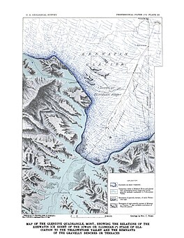
375:
Lindvall, R. M., 1962, Geology Of The Eagle Buttes
Quadrangle, Chouteau County, Montana, U. S. Geological Survey Miscellaneous Geological Investigations Map I-349.
1405:
368:
Howard, A. D., 1958, Drainage
Evolution In Northeastern Montana and Northwestern North Dakota, Bulletin of the Geological Society of America, v69, 575-588.
336:
Physiography and
Glacial Geology of Eastern Montana and Adjacent Areas; William C. Alden; United States Government Printing Office: Washington, D.C.; 1932
1395:
463:
44:
362:
Alden, W. C., 1958, Physiography And
Glacial Geology Of Eastern Montana And Adjacent Areas, U. S. Geological Survey Professional Paper 174.
292:
1410:
456:
354:
Geologic
Framework and Glaciation of the Central Area, 1-1-2006; Christopher L. Hill; Boise State University, Boise, Idaho; 2006
679:
1108:
1400:
1420:
1181:
1171:
549:
518:
1415:
1318:
1302:
1267:
395:
772:
930:
77:
28:
378:
Thornbury, W. D., 1965, Regional
Geomorphology Of The United States, John Wiley & Sons, Inc., New York.
1292:
1019:
1014:
301:
284:
73:
1272:
1257:
1088:
984:
979:
867:
857:
803:
797:
777:
441:
427:
272:
207:
158:
925:
253:
151:
1214:
280:
267:
and Yellowstone river valleys. The Glasgow sublobe blocked the Missouri River west of present-day
268:
144:
782:
448:
1252:
1000:
497:
381:
Trimble, D. E., 1980, The Geologic Story Of The Great Plains, Geological Survey Bulletin 1493.
245:
166:
1338:
1093:
1038:
989:
974:
422:
417:
1191:
886:
833:
762:
577:
482:
315:
1350:
1103:
1098:
946:
935:
915:
910:
843:
818:
767:
731:
726:
634:
587:
401:
309:
264:
257:
174:
1389:
1374:
1204:
1166:
1136:
1131:
1009:
964:
954:
920:
891:
747:
721:
629:
624:
582:
412:
407:
180:
1369:
1362:
1277:
1209:
1199:
1072:
1058:
852:
813:
808:
742:
698:
669:
664:
655:
572:
539:
534:
502:
305:
241:
132:
1262:
1176:
1161:
1141:
1067:
1048:
959:
901:
877:
823:
792:
787:
757:
737:
713:
703:
674:
479:
433:
300:. By 16,200 B.C. the ice had created glacial Lake Carmichael in the area of the
276:
263:
Ice of the Keewatin Lobe of the Laurentide Ice Sheet advanced westward into the
249:
1297:
1156:
1151:
1146:
1123:
1113:
1043:
1029:
862:
828:
592:
110:
97:
1232:
752:
689:
608:
385:
Nonglacial Geology: Conterminous U. S., The Geological Society of America.
544:
256:. As the ice sheet retreated northward, the lake drained into the modern
297:
145:
81:
304:. By 15,700 B.C. ice-free conditions may have existed in southwestern
159:
1224:
1287:
314:
1282:
283:
were formed to the east. The Yellowstone lobe spread south past
136:
127:
452:
248:. It formed in the valley of Yellowstone, during the late
16:
Glacial lake (former) in Dawson and Prairie, Montana
1311:
1245:
1223:
1190:
1122:
1081:
1057:
1028:
998:
944:
900:
876:
842:
712:
688:
654:
647:
617:
601:
565:
558:
527:
511:
490:
228:
224:
216:
206:
198:
190:
186:
173:
157:
143:
126:
87:
69:
21:
88:
291:. At its maximum the ice may have blocked the
464:
8:
651:
562:
471:
457:
449:
18:
329:
319:Map of Montana showing Lake Glendive.
51:
7:
169:or along the face of the Ice sheet.
1406:Glacial lakes of the United States
14:
1396:Former lakes of the United States
1368:
1356:
1344:
1332:
50:
43:
27:
215:
205:
197:
189:
33:Map of the Glendive Quadrangle
1:
680:Proglacial lakes of Minnesota
68:
194:about 80 miles (130 km)
202:about 30 miles (48 km)
1437:
1411:Natural history of Montana
550:West Siberian Glacial Lake
220:315 m (1,033 ft)
1327:
1319:List of prehistoric lakes
1303:Great Tehuelche Paleolake
396:List of prehistoric lakes
38:
26:
400:Proglacial lakes of the
111:47.119933°N 104.711266°W
773:Lake Houghton (glacial)
165:Over the divide to the
1015:Kankakee Outwash Plain
931:Glacial Lake Sammamish
320:
116:47.119933; -104.711266
980:Lake Jordan (Montana)
868:Glacial Lake Missoula
858:Glacial Lake Columbia
798:Nipissing Great Lakes
778:Glacial Lake Iroquois
318:
293:Little Missouri River
287:, and formed glacial
238:Glacial Lake Glendive
1339:Geography portal
1109:Lake Nantucket Sound
926:Glacial Lake Russell
152:Laurentide Ice Sheet
252:epoch south of the
107: /
1401:Geology of Montana
1351:History portal
804:Early Lake Ontario
321:
275:and glacial lakes
269:Fort Peck, Montana
254:Keewatin Ice Sheet
1421:Yellowstone River
1383:
1382:
1375:Oceans portal
1241:
1240:
911:Glacial Lake Hood
800:(Multiple basins)
734:(Multiple basins)
643:
642:
498:Lake Makgadikgadi
246:Yellowstone River
235:
234:
217:Surface elevation
167:Yellowstone River
1428:
1416:Proglacial lakes
1373:
1372:
1363:Lakes portal
1361:
1360:
1359:
1349:
1348:
1347:
1337:
1336:
1335:
1215:Lake San Agustín
1094:Lake Connecticut
1039:Lake Monongahela
990:Lake Musselshell
975:Lake Great Falls
652:
563:
485:and related seas
483:proglacial lakes
473:
466:
459:
450:
423:Lake Musselshell
418:Lake Great Falls
355:
352:
346:
345:A.D. Howard 1960
343:
337:
334:
161:
160:Primary outflows
147:
122:
121:
119:
118:
117:
112:
108:
105:
104:
103:
100:
90:
54:
53:
47:
31:
19:
1436:
1435:
1431:
1430:
1429:
1427:
1426:
1425:
1386:
1385:
1384:
1379:
1367:
1357:
1355:
1345:
1343:
1333:
1331:
1323:
1307:
1237:
1219:
1192:Rio Grande rift
1186:
1118:
1077:
1053:
1024:
994:
940:
896:
887:Lake Bonneville
872:
838:
834:Lake Whittlesey
763:Early Lake Erie
708:
684:
639:
613:
597:
578:Baltic Ice Lake
554:
523:
507:
486:
477:
392:
359:
358:
353:
349:
344:
340:
335:
331:
326:
285:Intake, Montana
177: countries
146:Primary inflows
115:
113:
109:
106:
101:
98:
96:
94:
93:
65:
64:
63:
62:
61:
60:
59:
55:
34:
17:
12:
11:
5:
1434:
1432:
1424:
1423:
1418:
1413:
1408:
1403:
1398:
1388:
1387:
1381:
1380:
1378:
1377:
1365:
1353:
1341:
1328:
1325:
1324:
1322:
1321:
1315:
1313:
1309:
1308:
1306:
1305:
1300:
1295:
1290:
1285:
1280:
1275:
1270:
1265:
1260:
1255:
1253:Lake Ballivián
1249:
1247:
1243:
1242:
1239:
1238:
1236:
1235:
1229:
1227:
1221:
1220:
1218:
1217:
1212:
1207:
1202:
1196:
1194:
1188:
1187:
1185:
1184:
1179:
1174:
1169:
1164:
1159:
1154:
1149:
1144:
1139:
1134:
1128:
1126:
1120:
1119:
1117:
1116:
1111:
1106:
1104:Lake Merrimack
1101:
1099:Lake Hitchcock
1096:
1091:
1085:
1083:
1079:
1078:
1076:
1075:
1070:
1064:
1062:
1055:
1054:
1052:
1051:
1046:
1041:
1035:
1033:
1026:
1025:
1023:
1022:
1020:Lake Wisconsin
1017:
1012:
1006:
1004:
996:
995:
993:
992:
987:
982:
977:
972:
967:
962:
957:
951:
949:
947:Missouri River
942:
941:
939:
938:
936:Lake Skokomish
933:
928:
923:
918:
916:Lake Nisqually
913:
907:
905:
898:
897:
895:
894:
889:
883:
881:
874:
873:
871:
870:
865:
860:
855:
849:
847:
844:Columbia River
840:
839:
837:
836:
831:
826:
821:
819:Lake Tonawanda
816:
811:
806:
801:
795:
790:
785:
780:
775:
770:
768:Lake Frontenac
765:
760:
755:
750:
745:
740:
735:
732:Lake Algonquin
729:
727:Lake Admiralty
724:
718:
716:
710:
709:
707:
706:
701:
695:
693:
686:
685:
683:
682:
677:
672:
667:
661:
659:
649:
645:
644:
641:
640:
638:
637:
635:Lake Pickering
632:
627:
621:
619:
615:
614:
612:
611:
605:
603:
599:
598:
596:
595:
590:
588:Mastogloia Sea
585:
580:
575:
569:
567:
560:
556:
555:
553:
552:
547:
542:
537:
531:
529:
525:
524:
522:
521:
515:
513:
509:
508:
506:
505:
500:
494:
492:
488:
487:
478:
476:
475:
468:
461:
453:
447:
446:
445:
444:
439:
436:
431:
425:
420:
415:
410:
402:Missouri River
398:
391:
388:
387:
386:
382:
379:
376:
373:
369:
366:
363:
357:
356:
347:
338:
328:
327:
325:
322:
310:Havre, Montana
271:, and created
258:Missouri River
233:
232:
230:
226:
225:
222:
221:
218:
214:
213:
210:
204:
203:
200:
196:
195:
192:
188:
187:
184:
183:
178:
171:
170:
163:
155:
154:
149:
141:
140:
130:
124:
123:
91:
85:
84:
71:
67:
66:
57:
56:
49:
48:
42:
41:
40:
39:
36:
35:
32:
24:
23:
15:
13:
10:
9:
6:
4:
3:
2:
1433:
1422:
1419:
1417:
1414:
1412:
1409:
1407:
1404:
1402:
1399:
1397:
1394:
1393:
1391:
1376:
1371:
1366:
1364:
1354:
1352:
1342:
1340:
1330:
1329:
1326:
1320:
1317:
1316:
1314:
1310:
1304:
1301:
1299:
1296:
1294:
1291:
1289:
1286:
1284:
1281:
1279:
1276:
1274:
1271:
1269:
1266:
1264:
1261:
1259:
1256:
1254:
1251:
1250:
1248:
1246:South America
1244:
1234:
1231:
1230:
1228:
1226:
1222:
1216:
1213:
1211:
1208:
1206:
1205:Lake Estancia
1203:
1201:
1198:
1197:
1195:
1193:
1189:
1183:
1182:Lake Thompson
1180:
1178:
1175:
1173:
1170:
1168:
1167:Lake Panamint
1165:
1163:
1160:
1158:
1155:
1153:
1150:
1148:
1145:
1143:
1140:
1138:
1137:Lake Corcoran
1135:
1133:
1132:Lake Cahuilla
1130:
1129:
1127:
1125:
1121:
1115:
1112:
1110:
1107:
1105:
1102:
1100:
1097:
1095:
1092:
1090:
1089:Lake Cape Cod
1087:
1086:
1084:
1080:
1074:
1071:
1069:
1066:
1065:
1063:
1060:
1056:
1050:
1047:
1045:
1042:
1040:
1037:
1036:
1034:
1031:
1027:
1021:
1018:
1016:
1013:
1011:
1010:Lake Kankakee
1008:
1007:
1005:
1002:
997:
991:
988:
986:
985:Lake McKenzie
983:
981:
978:
976:
973:
971:
970:Lake Glendive
968:
966:
965:Lake Cut Bank
963:
961:
958:
956:
955:Lake Chouteau
953:
952:
950:
948:
943:
937:
934:
932:
929:
927:
924:
922:
921:Lake Puyallup
919:
917:
914:
912:
909:
908:
906:
903:
899:
893:
892:Lake Lahontan
890:
888:
885:
884:
882:
879:
875:
869:
866:
864:
861:
859:
856:
854:
851:
850:
848:
845:
841:
835:
832:
830:
827:
825:
822:
820:
817:
815:
812:
810:
807:
805:
802:
799:
796:
794:
791:
789:
786:
784:
781:
779:
776:
774:
771:
769:
766:
764:
761:
759:
756:
754:
751:
749:
748:Lake Chippewa
746:
744:
741:
739:
736:
733:
730:
728:
725:
723:
722:Champlain Sea
720:
719:
717:
715:
711:
705:
702:
700:
697:
696:
694:
691:
687:
681:
678:
676:
673:
671:
668:
666:
663:
662:
660:
657:
653:
650:
648:North America
646:
636:
633:
631:
630:Lake Lapworth
628:
626:
625:Lake Harrison
623:
622:
620:
618:Great Britain
616:
610:
607:
606:
604:
600:
594:
591:
589:
586:
584:
583:Littorina Sea
581:
579:
576:
574:
571:
570:
568:
564:
561:
557:
551:
548:
546:
543:
541:
538:
536:
533:
532:
530:
526:
520:
519:Lake Washburn
517:
516:
514:
510:
504:
501:
499:
496:
495:
493:
489:
484:
481:
474:
469:
467:
462:
460:
455:
454:
451:
443:
442:Lake McKenzie
440:
438:Lake Glendive
437:
435:
432:
429:
426:
424:
421:
419:
416:
414:
413:Lake Chouteau
411:
409:
408:Lake Cut Bank
406:
405:
403:
399:
397:
394:
393:
389:
383:
380:
377:
374:
370:
367:
364:
361:
360:
351:
348:
342:
339:
333:
330:
323:
317:
313:
311:
307:
303:
302:Cypress Hills
299:
294:
290:
289:Lake Glendive
286:
282:
278:
274:
270:
266:
261:
259:
255:
251:
247:
244:on the lower
243:
239:
231:
227:
223:
219:
211:
209:
201:
193:
185:
182:
181:United States
179:
176:
172:
168:
164:
162:
156:
153:
150:
148:
142:
138:
134:
131:
129:
125:
120:
92:
86:
83:
79:
75:
72:
58:Lake Glendive
46:
37:
30:
25:
22:Lake Glendive
20:
1278:Lake Minchin
1210:Lake Palomas
1200:Lake Alamosa
1172:Lake Russell
1073:Lake Passaic
969:
853:Lake Allison
814:Lake Stanley
809:Lake Saginaw
743:Lake Chicago
699:Lake Ojibway
670:Lake Bassano
665:Lake Agassiz
656:Nelson River
573:Ancylus Lake
540:Lake Tengger
535:Lake Bandung
503:Lake Ptolemy
350:
341:
332:
306:Saskatchewan
288:
262:
242:glacial lake
237:
236:
208:Surface area
133:Glacial lake
1263:Lake Escara
1177:Lake Tecopa
1162:Lake Mojave
1142:Lake Harper
1082:New England
1068:Lake Albany
1049:Teays River
1001:Mississippi
960:Lake Circle
902:Puget Sound
878:Great Basin
824:Lake Warren
793:Lake Minong
788:Lake Maumee
758:Lake Duluth
738:Lake Arkona
714:Great Lakes
704:Tyrrell Sea
675:Lake Souris
480:Pleistocene
434:Lake Circle
428:Lake Jordan
273:Lake Jordan
250:Pleistocene
191:Max. length
114: /
102:104°42′41″W
89:Coordinates
1390:Categories
1298:Lake Tauca
1268:Inca Huasi
1157:Lake Modoc
1152:Lake Manly
1147:Lake Manix
1124:California
1114:Lake Stowe
1044:Lake Tight
863:Lake Lewis
829:Lake Wayne
783:Lake Lundy
593:Yoldia Sea
566:Baltic Sea
512:Antarctica
324:References
229:References
199:Max. width
99:47°07′12″N
1233:Lake Atna
753:Lake Dana
690:James Bay
609:Lake Komi
308:north of
128:Lake type
1032:drainage
1003:drainage
692:drainage
658:drainage
545:Mundafan
390:See also
265:Missouri
70:Location
1312:Summary
1293:Salinas
298:Alberta
281:Lambert
82:Montana
78:Prairie
1273:Mataro
1258:Cabana
1225:Alaska
1061:valley
1059:Hudson
999:Upper
945:Upper
904:system
880:system
846:system
602:Russia
559:Europe
491:Africa
404:Basin
277:Circle
240:was a
212:varied
137:former
74:Dawson
1288:Sajsi
175:Basin
1283:Ouki
1030:Ohio
528:Asia
279:and
76:and
372:NJ.
1392::
312:.
260:.
80:,
472:e
465:t
458:v
430:.
139:)
135:(
Text is available under the Creative Commons Attribution-ShareAlike License. Additional terms may apply.