50:
34:
57:
203:
who resided in New Jersey. Conversely, the name was derived from the fabricated name of a fictional Indian character in a long poem written by a local clergyman, George
William Lloyd (1821–1906) in
275:
92:
49:
285:
188:(formerly Round Pond) before flowing into the West Branch of the Paulins Kill. It is at an elevation of 866 feet (264 m).
280:
173:
270:
33:
177:
78:
38:
Lake Owassa in
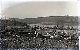
Frankford Township, New Jersey, as seen in 1896. Kittatinny Mountain is seen in the background.
228:
204:
191:
While the name Owassa implies an origin from Native
American languages, it is not derived from the
181:
185:
196:
192:
264:
239:
184:
along its western flank and by Bear Swamp. Water from Lake Owassa feeds into nearby
124:
169:
107:
94:
229:
U.S. Geological Survey
Geographic Names Information System: Lake Owassa
200:
165:
129:
255:
207:
for his deceased wife, Sarah Prince Lloyd (1819–1890).
147:
139:
135:
123:
84:
74:
21:
85:
8:
18:
164:) is a 275-acre (111 ha) freshwater
216:
224:
222:
220:
7:
56:
276:Lakes of Sussex County, New Jersey
14:
16:Lake in Sussex County, New Jersey
55:
48:
32:
146:
138:
286:Frankford Township, New Jersey
180:. It is fed from runoff from
1:
242:. Retrieved 27 February 2013.
73:
168:within the watershed of the
302:
256:http://www.lakeowassa.org/
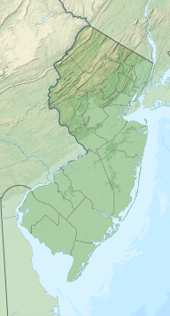
178:Sussex County, New Jersey
108:41.1512971°N 74.8117095°W
79:Sussex County, New Jersey
43:
31:
26:
151:866 ft (264 m)
205:Branchville, New Jersey
143:275 acres (111 ha)
113:41.1512971; -74.8117095
281:Paulins Kill watershed
240:Lake Owassa Nostalgia
271:Lakes of New Jersey
182:Kittatinny Mountain
104: /
174:Frankford Township
155:
154:
148:Surface elevation
293:
243:
237:
231:
226:
199:dialects of the
119:
118:
116:
115:
114:
109:
105:
102:
101:
100:
97:
87:
59:
58:
52:
36:
19:
301:
300:
296:
295:
294:
292:
291:
290:
261:
260:
252:
247:
246:
238:
234:
227:
218:
213:
112:
110:
106:
103:
98:
95:
93:
91:
90:
70:
69:
68:
67:
66:
65:
64:
60:
39:
17:
12:
11:
5:
299:
297:
289:
288:
283:
278:
273:
263:
262:
259:
258:
251:
250:External links
248:
245:
244:
232:
215:
214:
212:
209:
153:
152:
149:
145:
144:
141:
137:
136:
133:
132:
127:
121:
120:
88:
82:
81:
76:
72:
71:
62:
61:
54:
53:
47:
46:
45:
44:
41:
40:
37:
29:
28:
24:
23:
15:
13:
10:
9:
6:
4:
3:
2:
298:
287:
284:
282:
279:
277:
274:
272:
269:
268:
266:
257:
254:
253:
249:
241:
236:
233:
230:
225:
223:
221:
217:
210:
208:
206:
202:
198:
194:
189:
187:
186:Culver's Lake
183:
179:
175:
171:
167:
163:
159:
150:
142:
134:
131:
128:
126:
122:
117:
89:
83:
80:
77:
51:
42:
35:
30:
25:
20:
235:
190:
170:Paulins Kill
161:
157:
156:
140:Surface area
172:located in
158:Lake Owassa
111: /
86:Coordinates
63:Lake Owassa
22:Lake Owassa
265:Categories
211:References
160:(formerly
99:74°48′42″W
96:41°09′05″N
162:Long Pond
27:Long Pond
75:Location
201:Lenape
197:Munsee
193:Unami
166:lake
130:lake
125:Type
195:or
176:in
267::
219:^
Text is available under the Creative Commons Attribution-ShareAlike License. Additional terms may apply.