260:(schistosomiasis), unlike all other freshwater lakes in Ethiopia, Lake Langano is popular with tourists and city-dwellers. The lake is brown in colour and at first sight one may think that the lake is not clean. However this is not the case, the reason for the colour is due to the richness of minerals including high sulphur levels which have led many to believe that the lake water has healing properties. There are a number of resorts around the lake and water sports are popular. There is a variety of wildlife around the lake, which include
49:
230:
238:
36:
56:
283:
near this lake, the first in 1906 (a magnitude 6.8 on the
Richter scale), and the second in 1985 (magnitude 6.2). After the earthquake of 1906 there formed a 25–30 m tall geyser on Edo Laki Island on the northern part of the lake. The geyser disappeared circa 1966 – 1970, leaving a hot spring.
249:, Lake Langano is 18 kilometers long and 16 km wide, with a surface area of 230 square kilometers and a maximum depth of 46 meters. The lake's catchment area is 1,600 square kilometers in size, and is drained by the Hora Kallo river which empties into the adjacent
755:
76:
693:
276:, and a huge variety of birds. The area around the lake is largely deforested, however, and a large number of herders live around the area.
246:
48:
659:
90:
750:
710:
691:"Earthquake Risks in Addis Ababa and other Major Ethiopian Cities – Will the Country be Caught Off-guarded?"
690:
218:
229:
656:
735:
620:
560:
676:
190:
760:
697:
663:
257:
237:
206:
35:
182:
122:
75:
744:
486:
250:
214:
194:
296:
Climate data for Lake
Langano, elevation 1,600 m (5,200 ft), (1971–2000)
261:
202:
20:
105:
92:
280:
210:
639:
Neumann, "From the Somali Coast through
Southern Ethiopia to the Sudan",
273:
198:
265:
269:
228:
700:
by Dr. Samuel Kinde, published March 2002 (accessed 4 June 2008)
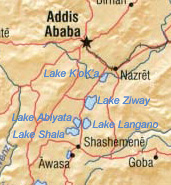
201:, exactly 200 kilometers by road south of the capital,
713:. Food and Agriculture Organization of United Nations
168:
160:
152:
144:
136:
132:
121:
82:
28:
681:, (Cambridge: IUCN, UNEP and WCMC, 1992), p. 159
83:
675:Robert Mepham, R. H. Hughes, and J. S. Hughes,
736:Late Evening on Lake Langano Nature Soundscape
8:
23:in southern Switzerland and northern Italy.
292:
25:
236:
632:
245:According to figures published by the
7:
55:
14:
221:at an elevation of 1,585 meters.
156:230 km (89 sq mi)
74:
54:
47:
34:
678:A directory of African wetlands
213:. It is located to the east of
167:
159:
151:
143:
135:
16:Lake in Oromia Region, Ethiopia
756:Lakes of the Great Rift Valley
1:
193:: ላንጋኖ ሐይቅ) is a lake in the
657:CSA 2005 National Statistics
205:, on the border between the
172:1,585 m (5,200 ft)
711:"CLIMWAT climatic database"
647:(October 1902), pp. 373–398
415:Mean daily minimum °C (°F)
345:Mean daily maximum °C (°F)
777:
606:
295:
279:Two earthquakes had their
247:Central Statistical Agency
233:Sunrise over Lake Langano.
18:
558:
484:
414:
344:
339:
336:
333:
330:
327:
324:
321:
318:
315:
312:
309:
306:
303:
300:
73:
42:
33:
148:16 km (9.9 mi)
19:Not to be confused with
164:46 m (151 ft)
140:18 km (11 mi)
242:
234:
240:
232:
641:Geographical Journal
219:Main Ethiopian Rift
102: /
696:2010-02-25 at the
662:2008-07-31 at the
243:
235:
751:Lakes of Ethiopia
621:Rift Valley lakes
611:
610:
561:relative humidity
256:As it is free of
176:
175:
169:Surface elevation
768:
723:
722:
720:
718:
707:
701:
688:
682:
673:
667:
654:
648:
637:
293:
117:
116:
114:
113:
112:
107:
106:7.600°N 38.717°E
103:
100:
99:
98:
95:
85:
78:
58:
57:
51:
38:
26:
776:
775:
771:
770:
769:
767:
766:
765:
741:
740:
732:
727:
726:
716:
714:
709:
708:
704:
698:Wayback Machine
689:
685:
674:
670:
664:Wayback Machine
655:
651:
638:
634:
629:
617:
612:
553:
548:
543:
538:
533:
528:
523:
518:
513:
508:
503:
498:
493:
479:
474:
469:
464:
459:
454:
449:
444:
439:
434:
429:
424:
419:
409:
404:
399:
394:
389:
384:
379:
374:
369:
364:
359:
354:
349:
290:
227:
207:East Shewa Zone
125: countries
110:
108:
104:
101:
96:
93:
91:
89:
88:
69:
68:
67:
66:
65:
64:
63:
59:
24:
17:
12:
11:
5:
774:
772:
764:
763:
758:
753:
743:
742:
739:
738:
731:
730:External links
728:
725:
724:
702:
683:
668:
649:
631:
630:
628:
625:
624:
623:
616:
613:
609:
608:
604:
603:
600:
597:
594:
591:
588:
585:
582:
579:
576:
573:
570:
567:
564:
556:
555:
550:
545:
540:
535:
530:
525:
520:
515:
510:
505:
500:
495:
490:
482:
481:
476:
471:
466:
461:
456:
451:
446:
441:
436:
431:
426:
421:
416:
412:
411:
406:
401:
396:
391:
386:
381:
376:
371:
366:
361:
356:
351:
346:
342:
341:
338:
335:
332:
329:
326:
323:
320:
317:
314:
311:
308:
305:
302:
298:
297:
291:
289:
286:
226:
223:
187:Hora Langaanoo
174:
173:
170:
166:
165:
162:
158:
157:
154:
150:
149:
146:
142:
141:
138:
134:
133:
130:
129:
126:
119:
118:
86:
80:
79:
71:
70:
61:
60:
53:
52:
46:
45:
44:
43:
40:
39:
31:
30:
15:
13:
10:
9:
6:
4:
3:
2:
773:
762:
759:
757:
754:
752:
749:
748:
746:
737:
734:
733:
729:
712:
706:
703:
699:
695:
692:
687:
684:
680:
679:
672:
669:
665:
661:
658:
653:
650:
646:
642:
636:
633:
626:
622:
619:
618:
614:
605:
601:
598:
595:
592:
589:
586:
583:
580:
577:
574:
571:
568:
565:
562:
557:
551:
546:
541:
536:
531:
526:
521:
516:
511:
506:
501:
496:
491:
488:
487:precipitation
483:
477:
472:
467:
462:
457:
452:
447:
442:
437:
432:
427:
422:
417:
413:
407:
402:
397:
392:
387:
382:
377:
372:
367:
362:
357:
352:
347:
343:
299:
294:
287:
285:
282:
277:
275:
271:
267:
263:
259:
254:
252:
251:Lake Abijatta
248:
239:
231:
224:
222:
220:
216:
215:Lake Abijatta
212:
208:
204:
200:
196:
195:Oromia Region
192:
188:
184:
180:
171:
163:
155:
147:
139:
131:
127:
124:
120:
115:
111:7.600; 38.717
87:
81:
77:
72:
50:
41:
37:
32:
27:
22:
715:. Retrieved
705:
686:
677:
671:
652:
644:
640:
635:
607:Source: FAO
489:mm (inches)
278:
255:
244:
241:Lake Langano
186:
179:Lake Langano
178:
177:
153:Surface area
62:Lake Langano
29:Lake Langano
666:, Table A.2
203:Addis Ababa
137:Max. length
109: /
84:Coordinates
21:Lake Lugano
745:Categories
211:Arsi Zones
161:Max. depth
145:Max. width
281:epicenter
258:Bilharzia
694:Archived
660:Archived
615:See also
559:Average
554:(20.07)
485:Average
274:warthogs
264:(rare),
225:Overview
199:Ethiopia
128:Ethiopia
717:23 June
549:(0.20)
544:(0.31)
539:(0.51)
534:(2.28)
529:(2.95)
524:(4.45)
519:(3.43)
514:(2.09)
509:(1.02)
504:(1.38)
499:(0.47)
494:(0.98)
480:(56.3)
475:(51.3)
470:(52.2)
465:(54.7)
460:(57.6)
455:(58.1)
450:(58.1)
445:(58.6)
440:(59.2)
435:(58.6)
430:(55.6)
425:(54.5)
420:(56.5)
410:(80.0)
405:(78.6)
400:(79.3)
395:(79.7)
390:(78.8)
385:(78.3)
380:(76.3)
375:(79.9)
370:(81.0)
365:(83.7)
360:(83.3)
355:(81.1)
350:(79.5)
288:Climate
270:baboons
266:monkeys
217:in the
191:Amharic
97:38°43′E
761:Oromia
301:Month
262:hippos
94:7°36′N
627:Notes
522:113.0
340:Year
183:Oromo
123:Basin
719:2024
563:(%)
537:13.0
532:58.0
527:75.0
517:87.0
512:53.0
507:26.0
502:35.0
497:12.0
492:25.0
478:13.5
473:10.7
468:11.2
463:12.6
458:14.2
453:14.5
448:14.5
443:14.8
438:15.1
433:14.8
428:13.1
423:12.5
418:13.6
408:26.6
403:25.9
398:26.3
393:26.5
388:26.0
383:25.7
378:24.6
373:26.6
368:27.2
363:28.7
358:28.5
353:27.3
348:26.4
337:Dec
334:Nov
331:Oct
328:Sep
325:Aug
322:Jul
319:Jun
316:May
313:Apr
310:Mar
307:Feb
304:Jan
209:and
602:60
599:54
596:60
593:65
590:68
587:67
584:68
581:64
578:62
575:58
572:50
569:48
566:50
552:510
547:5.0
542:8.0
197:of
747::
645:20
643:,
272:,
268:,
253:.
189:,
185::
721:.
181:(
Text is available under the Creative Commons Attribution-ShareAlike License. Additional terms may apply.