1026:
969:
47:
54:
31:
277:
The lake has a maximum depth of 50 metres (160 ft), a relative depth of 2.8%, and an annually fluctuating water level of only 0.5 metres (1.6 ft) to 0.75 metres (2.5 ft). Upper reaches of the lake are shallow (1 to 4 m), with a sinuous channel constricted by a narrow ignimbrite gorge.
375:
Since its creation the
Matahina dam has acted as an effective barrier to the seaward movement of sediment by the Rangitaiki River. Pre-dam annual discharge figures for suspended and bed load sediment near the river mouth were about 201 000 and 188 000 tonne respectively, but equivalent post-dam
602:
376:
values have dropped to 65 000 and 10 000 tonne. This trapping of sediment has halted or substantially reduced the downstream historical rising river bed and coastal progradation of the
Rangitaiki plains.
278:
As the gorge widens down lake, the depth increases to15 metres (49 ft) along a delta front, and to 40 metres (130 ft) to 50 metres (160 ft) in the basin immediately behind the dam.
379:
While principal capture of sediment occurs at the upstream
Aniwhenua dam which was completed in 1982, an increasing amount of sediment is being deposited in the deep portion of Lake Matahina.
1025:
1010:
1092:
500:
1082:
873:
309:
Shall not exceed this level in all except “Emergency
Condition” situations (as defined in Trustpower's “Lake Matahina Flood Management Plan”).
103:
658:
1063:
1087:
1003:
421:
551:
168:
801:
791:
996:
848:
576:
924:
46:
651:
405:. 2nd International Conference on Case Histories in Geotechnical Engineering. St Louis, MO. pp. 841–848.
1056:
918:
771:
888:
251:
261:
In 1969, five children drowned after driving a car into Lake
Matahina at a camp that New Zealand author
720:
700:
603:
Matahina
Hydroelectric Power Scheme Reconsenting Project: River Hydrology, Hydraulics and Bank Erosion
976:
746:
705:
265:
helped to run. Crump was charged with manslaughter over the deaths, but these charges were dropped.
1097:
906:
710:
644:
863:
832:
817:
400:
1049:
948:
822:
715:
1033:
980:
269:, one of Crump's ex-wives, said that it was negligence on his behalf that the children died.
942:
853:
667:
477:
467:
255:
150:
968:
353:
No generation below this level. Spillway gates reliant on mains power or back-up generator
894:
679:
557:(Report). Rangitāiki River Scheme Review Panel. 18 September 2017. pp. 15, 16, 73, 75
936:
526:
1076:
930:
912:
882:
858:
686:
235:
135:
81:
455:
900:
266:
85:
67:
472:
796:
262:
239:
89:
782:
736:
425:
118:
105:
766:
140:
364:
Approval is required from Bay of Plenty
Regional Council to go below 71.6.
30:
630:
756:
741:
243:
761:
751:
247:
482:
811:
Lakes in catchment (upstream to downstream by location or tributary)
456:"Sedimentation in an Artificial Lake - Lake Matahina, Bay of Plenty"
636:
525:
Taonga, New
Zealand Ministry for Culture and Heritage Te Manatu.
454:
Phillips, Christopher John; Nelson, Campbell S. (December 1981).
640:
501:"Poet Fleur Adcock attacks her ex-husband Barry Crump in verse"
314:
Maximum Lake level during floods of less than 200 cumecs
1037:
984:
552:
Rangitāiki River Scheme Review – April 2017 Flood Event
466:(4). Wellington: Royal Society Te Apārangi: 459–473.
460:
New
Zealand Journal of Marine and Freshwater Research
872:
841:
810:
780:
729:
693:
217:
209:
201:
193:
189:
174:
164:
156:
146:
134:
95:
77:
23:
358:Extreme Minimum Level (major flood >500 cumecs)
402:The Observed Seismic Behavior of the Matahina Dam
254:and its associated 86 m tall Matahina Dam on the
250:. The lake was formed by the construction of the
242:, located immediately south of the settlement of
96:
730:Towns and settlements (upstream to downstream)
1057:
1004:
781:Major tributaries (upstream to downstream by
652:
608:(Report). Beca Infrastructure Ltd. p. 16
416:
414:
412:
8:
286:The lake's operating levels are as follows:
1064:
1050:
1011:
997:
659:
645:
637:
449:
447:
445:
443:
288:
20:
633:. Describes swimming options at the lake.
481:
471:
295:Level (referenced to the Moturiki Datum)
16:Lake in Bay of Plenty region, New Zealand
842:Other features (upstream to downstream)
388:
320:This is the spillway date crest level.
394:
392:
53:
7:
1093:Bay of Plenty Region geography stubs
1022:
1020:
965:
963:
495:
493:
1036:. You can help Knowledge (XXG) by
983:. You can help Knowledge (XXG) by
205:2.3 km (0.89 sq mi)
14:
1083:Lakes of the Bay of Plenty Region
66:Location of Lake Matahina in the
1024:
967:
631:Rangitaiki River at Matahina Dam
582:. Bay of Plenty Regional Council
52:
45:
29:
1032:This article about a lake is a
399:Gillon, M. D. (1–5 June 1988).
258:, which was completed in 1967.
216:
208:
200:
192:
601:Millais, Peter (13 May 2009).
336:Minimum Normal Operating Level
331:Normal upper operating limit.
325:Maximum Normal Operating Level
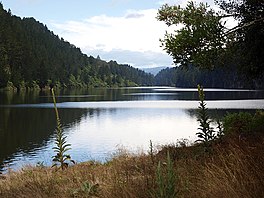
35:Lakeside view of Lake Matahina
1:
849:North Island Volcanic Plateau
473:10.1080/00288330.1981.9515938
347:Minimum Level (flood pending)
342:Normal lower operating limit
76:
1114:
1019:
962:
874:Longest New Zealand rivers
1088:Reservoirs in New Zealand
674:
40:
28:
577:"Resource Consent 65750"
422:"Matahina Dam Fact File"
979:geography article is a
246:and 50 km east of
213:50 m (160 ft)
197:6 km (3.7 mi)
252:Matahina Power Station
234:is a reservoir in the
221:55,000,000 m (1.9
119:38.11806°S 176.81667°E
165:Construction engineer
925:Waiau Toa / Clarence
706:Bay of Plenty region
694:Administrative areas
124:-38.11806; 176.81667
711:Rangitikei District
225:10 cu ft)
115: /
721:Whakatāne District
701:Hawke's Bay region
303:Design Flood Level
1045:
1044:
992:
991:
957:
956:
424:(Press release).
368:
367:
229:
228:
169:Ministry of Works
1105:
1066:
1059:
1052:
1028:
1021:
1013:
1006:
999:
971:
964:
889:Clutha / Mata-Au
854:Kaingaroa Forest
668:Rangitaiki River
661:
654:
647:
638:
618:
617:
615:
613:
607:
598:
592:
591:
589:
587:
581:
573:
567:
566:
564:
562:
556:
548:
542:
541:
539:
537:
522:
516:
515:
513:
511:
497:
488:
487:
485:
475:
451:
438:
437:
435:
433:
418:
407:
406:
396:
289:
256:Rangitaiki River
224:
185:
183:
151:Rangitaiki River
130:
129:
127:
126:
125:
120:
116:
113:
112:
111:
108:
98:
56:
55:
49:
33:
21:
1113:
1112:
1108:
1107:
1106:
1104:
1103:
1102:
1073:
1072:
1071:
1070:
1018:
1017:
960:
958:
953:
868:
837:
806:
802:Whirinaki River
776:
725:
689:
680:Ahimanawa Range
670:
665:
627:
622:
621:
611:
609:
605:
600:
599:
595:
585:
583:
579:
575:
574:
570:
560:
558:
554:
550:
549:
545:
535:
533:
524:
523:
519:
509:
507:
499:
498:
491:
453:
452:
441:
431:
429:
428:. 13 April 2020
420:
419:
410:
398:
397:
390:
385:
373:
284:
275:
222:
181:
179:
123:
121:
117:
114:
109:
106:
104:
102:
101:
73:
72:
71:
70:
64:
63:
62:
61:
57:
36:
17:
12:
11:
5:
1111:
1109:
1101:
1100:
1095:
1090:
1085:
1075:
1074:
1069:
1068:
1061:
1054:
1046:
1043:
1042:
1029:
1016:
1015:
1008:
1001:
993:
990:
989:
972:
955:
954:
952:
951:
945:
939:
933:
927:
921:
915:
909:
903:
897:
891:
885:
878:
876:
870:
869:
867:
866:
861:
856:
851:
845:
843:
839:
838:
836:
835:
830:
825:
823:Lake Āniwaniwa
820:
814:
812:
808:
807:
805:
804:
799:
794:
792:Otamatea River
788:
786:
778:
777:
775:
774:
769:
764:
759:
754:
749:
744:
739:
733:
731:
727:
726:
724:
723:
718:
716:Taupō District
713:
708:
703:
697:
695:
691:
690:
675:
672:
671:
666:
664:
663:
656:
649:
641:
635:
634:
626:
625:External links
623:
620:
619:
593:
568:
543:
517:
489:
439:
408:
387:
386:
384:
381:
372:
369:
366:
365:
362:
359:
355:
354:
351:
348:
344:
343:
340:
337:
333:
332:
329:
326:
322:
321:
318:
315:
311:
310:
307:
304:
300:
299:
296:
293:
283:
280:
274:
271:
227:
226:
219:
215:
214:
211:
207:
206:
203:
199:
198:
195:
191:
190:
187:
186:
176:
172:
171:
166:
162:
161:
158:
154:
153:
148:
144:
143:
138:
132:
131:
99:
93:
92:
79:
75:
74:
65:
59:
58:
51:
50:
44:
43:
42:
41:
38:
37:
34:
26:
25:
15:
13:
10:
9:
6:
4:
3:
2:
1110:
1099:
1096:
1094:
1091:
1089:
1086:
1084:
1081:
1080:
1078:
1067:
1062:
1060:
1055:
1053:
1048:
1047:
1041:
1039:
1035:
1030:
1027:
1023:
1014:
1009:
1007:
1002:
1000:
995:
994:
988:
986:
982:
978:
977:Bay of Plenty
973:
970:
966:
961:
950:
946:
944:
940:
938:
934:
932:
928:
926:
922:
920:
916:
914:
910:
908:
904:
902:
898:
896:
892:
890:
886:
884:
880:
879:
877:
875:
871:
865:
862:
860:
859:Aniwhenua Dam
857:
855:
852:
850:
847:
846:
844:
840:
834:
831:
829:
828:Lake Matahina
826:
824:
821:
819:
816:
815:
813:
809:
803:
800:
798:
795:
793:
790:
789:
787:
784:
779:
773:
770:
768:
765:
763:
760:
758:
755:
753:
750:
748:
745:
743:
740:
738:
735:
734:
732:
728:
722:
719:
717:
714:
712:
709:
707:
704:
702:
699:
698:
696:
692:
688:
687:Bay of Plenty
685:
681:
678:
673:
669:
662:
657:
655:
650:
648:
643:
642:
639:
632:
629:
628:
624:
604:
597:
594:
578:
572:
569:
553:
547:
544:
532:
531:teara.govt.nz
528:
521:
518:
506:
502:
496:
494:
490:
484:
479:
474:
469:
465:
461:
457:
450:
448:
446:
444:
440:
427:
423:
417:
415:
413:
409:
404:
403:
395:
393:
389:
382:
380:
377:
371:Sedimentation
370:
363:
360:
357:
356:
352:
349:
346:
345:
341:
338:
335:
334:
330:
327:
324:
323:
319:
316:
313:
312:
308:
305:
302:
301:
297:
294:
291:
290:
287:
281:
279:
272:
270:
268:
264:
259:
257:
253:
249:
245:
241:
237:
236:Bay of Plenty
233:
232:Lake Matahina
220:
212:
204:
196:
188:
177:
175:First flooded
173:
170:
167:
163:
159:
155:
152:
149:
147:River sources
145:
142:
139:
137:
133:
128:
100:
94:
91:
87:
83:
82:Bay of Plenty
80:
69:
60:Lake Matahina
48:
39:
32:
27:
24:Lake Matahina
22:
19:
1038:expanding it
1031:
985:expanding it
974:
959:
864:Matahina Dam
833:Lake Otumahi
827:
818:Lake Pouarua
683:
676:
612:20 September
610:. Retrieved
596:
584:. Retrieved
571:
559:. Retrieved
546:
534:. Retrieved
530:
520:
508:. Retrieved
504:
463:
459:
430:. Retrieved
401:
378:
374:
292:Description
285:
276:
267:Fleur Adcock
260:
231:
230:
218:Water volume
202:Surface area
160:1960 to 1967
86:North Island
68:North Island
18:
797:Wheao River
684:Flows into:
561:9 September
527:"Biography"
282:Lake levels
263:Barry Crump
240:New Zealand
194:Max. length
122: /
97:Coordinates
90:New Zealand
1098:Lake stubs
1077:Categories
943:Rangitaiki
907:Rangitīkei
783:confluence
737:Rangitaiki
483:10289/4737
426:Trustpower
383:References
350:71.60 m RL
339:73.15 m RL
238:region of
210:Max. depth
110:176°49′0″E
895:Whanganui
767:Edgecumbe
586:5 October
505:NZ Herald
361:70.0 m RL
328:76.2 m RL
317:76.4 m RL
306:76.8 m RL
298:Comments
141:reservoir
949:Manawatū
772:Thornton
757:Te Mahoe
742:Murupara
244:Te Mahoe
107:38°7′5″S
78:Location
931:Waitaki
913:Mataura
883:Waikato
762:Te Teko
752:Waiohau
747:Galatea
677:Source:
536:21 June
510:21 June
248:Rotorua
180: (
901:Taieri
432:14 May
975:This
937:Ōreti
919:Waiau
606:(PDF)
580:(PDF)
555:(PDF)
273:Depth
157:Built
1034:stub
981:stub
947:12:
941:11:
935:10:
614:2021
588:2021
563:2021
538:2021
512:2021
434:2020
182:1967
178:1967
136:Type
929:9:
923:8:
917:7:
911:6:
905:5:
899:4:
893:3:
887:2:
881:1:
478:hdl
468:doi
1079::
529:.
503:.
492:^
476:.
464:15
462:.
458:.
442:^
411:^
391:^
88:,
84:,
1065:e
1058:t
1051:v
1040:.
1012:e
1005:t
998:v
987:.
785:)
682:—
660:e
653:t
646:v
616:.
590:.
565:.
540:.
514:.
486:.
480::
470::
436:.
223:×
184:)
Text is available under the Creative Commons Attribution-ShareAlike License. Additional terms may apply.