585:
60:
525:
44:
633:
609:
883:
573:
936:
621:
537:
432:
561:
597:
424:
549:
67:
584:
505:
Surrounding the lake, there are numerous parks as well as walking trails, such as the
Waterfront Forest Lane (Takarada Nature Observation Trail) and the Nishiyama Sanroku Crater Trail. Several
59:
513:
offer a view of the lake. There are also several hand and footbaths nearby. Uniquely, large vending machines near the onsen offer spring water that can be taken to be used at home.
973:
412:
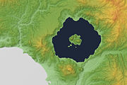
lies on the southern rim of the caldera. The lake is nearly circular, being 10 kilometers in diameter from the eastwest and 9 kilometers from the northsouth. The town of
524:
608:
920:
632:
966:
1002:
572:
108:
494:
1022:
1027:
959:
620:
772:
536:
318:
913:
596:
443:), and the second most transparent lake in Japan. Nakajima Island (not to be confused with another island of the same name in
997:
548:
1017:
992:
741:
696:
385:
1007:
906:
719:
560:
43:
1012:
835:
389:
840:
401:
331:
714:
335:
198:
439:
Lake Tōya is said to be the northernmost lake in Japan that never ices (with competing claim by nearby
417:
148:
942:
This article about a national/quasi-national park or protected area in Japan, or related topic is a
935:
882:
701:
510:
413:
90:
651:
155:
870:
768:
350:
764:
758:
687:
448:
431:
943:
890:
679:
423:
225:
986:
479:
444:
440:
405:
140:
806:
704:
is based on this lake as the Sinnoh region is a fictionalized version of
Hokkaido.
467:
393:
94:
830:
323:
Collectively known as Naka-jima: Ō-shima, Benten-jima, Kannon-jima, Manjū-jima
145:
400:. It is part of "Toya Caldera and Usu Volcano Global Geopark" which joins in
123:
110:
471:
409:
660:
17:
378:
156:
763:(Second ed.). Chico, California: Moon Publications, Inc. p.
199:
675:
466:ウン (kim'un) means "in the mountain" and ト (to) means "lake") by the
865:
506:
430:
422:
397:
416:
comprises most of the area surrounding the lake and the town of
381:
614:
Monument located on Oshima (Nakajima) in Lake Toya (June 2022)
860:
490:
590:
Ukimido Park on the northern shore of the lake (June 2006)
847:
947:
894:
757:
Bisignani, J.D. (December 1993). Taran March (ed.).
341:
327:
317:
307:
303:
295:
287:
279:
271:
263:
255:
247:
239:
235:
224:
197:
154:
139:
100:
86:
34:
101:
807:"Lake Toya - Hokkaido Travel Guide | Planetyze"
796:(Second ed.). Tokyo: Methodist Publishing House
486:, which means "lakeshore, land around a lake."
370:
214:
187:
171:
667:
364:
208:
181:
165:
967:
914:
685:It is the model for Lake Kiriya in the anime
554:Lake Toya with the calm surface (August 2007)
8:
578:View from near Toyako Onsen (September 2008)
788:
786:
784:
451:in the middle of the lake which houses the
974:
960:
921:
907:
31:
542:Nakajima seen from Mt. Poromoi (May 2009)
731:
638:Nakajima Lake Forest Museum (June 2022)
626:Pier in front of the museum (June 2022)
530:Lake Toya and Nakajima (September 2013)
520:
495:The Windsor Hotel Toya Resort & Spa
737:
735:
66:
7:
932:
930:
889:This Hokkaidō location article is a
879:
877:
752:
750:
602:Lake Toya and Nakajima (August 2014)
435:Lake Tōya, Tōya town and volcano Usu
794:An Ainu-English-Japanese Dictionary
474:, Japanese pioneers named the lake
283:8.19 km (1.96 cu mi)
259:70.7 km (27.3 sq mi)
25:
493:Summit was held at Lake Tōya and
934:
881:
631:
619:
607:
595:
583:
571:
559:
547:
535:
523:
420:is located on the eastern side.
65:
58:
42:
294:
286:
278:
270:
262:
254:
246:
238:
1:
848:Geographical Survey Institute
742:Geographical Survey Institute
655:is on the shores of the lake.
649:The setting of the 2012 film
85:
946:. You can help Knowledge by
893:. You can help Knowledge by
873:- Geological Survey of Japan
267:117.0 m (383.9 ft)
1003:Shikotsu-Tōya National Park
386:Shikotsu-Toya National Park
371:
215:
188:
172:
1044:
1028:Japan protected area stubs
929:
876:
720:List of volcanoes in Japan
351:not a well-defined measure
48:Lake Tōya (September 2013)
850:, last access 28 May 2008
697:Pokémon Diamond and Pearl
668:
365:
348:
275:180 m (590 ft)
209:
182:
166:
53:
41:
1023:Hokkaidō geography stubs
836:Global Volcanism Program
792:Batchelor, John. (1905)
682:(坂田 銀時, Sakata Gintoki).
243:10 km (6.2 mi)
841:Smithsonian Institution
658:In the manga and anime
509:managed by the town of
453:Tōya Lake Forest Museum
402:Global Geoparks Network
299:84 m (276 ft)
291:46 km (29 mi)
251:9 km (5.6 mi)
715:List of lakes in Japan
678:of the main character
436:
428:
124:42.57889°N 140.85444°E
998:Volcanic crater lakes
458:Lake Tōya was called
434:
426:
1018:Pleistocene calderas
993:Calderas of Hokkaido
674:is engraved on the
566:Lake Toya in winter
129:42.57889; 140.85444
120: /
91:Iburi Subprefecture
861:Guide of Lake Toya
652:Bread of Happiness
644:In popular culture
437:
429:
1008:Lakes of Hokkaido
955:
954:
902:
901:
465:
357:
356:
332:Sōbetsu, Hokkaidō
296:Surface elevation
16:(Redirected from
1035:
976:
969:
962:
938:
931:
923:
916:
909:
885:
878:
866:Toya Usu Geopark
844:
822:
821:
819:
817:
803:
797:
790:
779:
778:
754:
745:
739:
702:Pokémon Platinum
688:Celestial Method
673:
671:
670:
635:
623:
611:
599:
587:
575:
563:
551:
539:
527:
463:
449:recursive island
376:
374:
368:
367:
349:Shore length is
336:Tōyako, Hokkaidō
220:
218:
212:
211:
201:
200:Primary outflows
193:
191:
185:
184:
177:
175:
169:
168:
158:
135:
134:
132:
131:
130:
125:
121:
118:
117:
116:
113:
103:
69:
68:
62:
46:
32:
21:
1043:
1042:
1038:
1037:
1036:
1034:
1033:
1032:
1013:VEI-7 volcanoes
983:
982:
981:
980:
928:
927:
857:
829:
826:
825:
815:
813:
805:
804:
800:
791:
782:
775:
756:
755:
748:
740:
733:
728:
711:
694:Lake Verity in
665:
646:
639:
636:
627:
624:
615:
612:
603:
600:
591:
588:
579:
576:
567:
564:
555:
552:
543:
540:
531:
528:
519:
503:
362:
228: countries
206:
179:
178:, Sōbetsu River
163:
157:Primary inflows
128:
126:
122:
119:
114:
111:
109:
107:
106:
82:
81:
80:
79:
78:
77:
76:
74:
70:
49:
36:
28:
23:
22:
15:
12:
11:
5:
1041:
1039:
1031:
1030:
1025:
1020:
1015:
1010:
1005:
1000:
995:
985:
984:
979:
978:
971:
964:
956:
953:
952:
939:
926:
925:
918:
911:
903:
900:
899:
886:
875:
874:
868:
863:
856:
855:External links
853:
852:
851:
845:
824:
823:
798:
780:
773:
760:Japan Handbook
746:
744:map 25000:1 洞爺
730:
729:
727:
724:
723:
722:
717:
710:
707:
706:
705:
692:
683:
680:Gintoki Sakata
656:
645:
642:
641:
640:
637:
630:
628:
625:
618:
616:
613:
606:
604:
601:
594:
592:
589:
582:
580:
577:
570:
568:
565:
558:
556:
553:
546:
544:
541:
534:
532:
529:
522:
518:
515:
502:
499:
390:Abuta District
377:is a volcanic
355:
354:
346:
345:
343:
339:
338:
329:
325:
324:
321:
315:
314:
309:
305:
304:
301:
300:
297:
293:
292:
289:
285:
284:
281:
277:
276:
273:
269:
268:
265:
261:
260:
257:
253:
252:
249:
245:
244:
241:
237:
236:
233:
232:
229:
222:
221:
203:
195:
194:
160:
152:
151:
143:
137:
136:
104:
98:
97:
88:
84:
83:
72:
71:
64:
63:
57:
56:
55:
54:
51:
50:
47:
39:
38:
26:
24:
14:
13:
10:
9:
6:
4:
3:
2:
1040:
1029:
1026:
1024:
1021:
1019:
1016:
1014:
1011:
1009:
1006:
1004:
1001:
999:
996:
994:
991:
990:
988:
977:
972:
970:
965:
963:
958:
957:
951:
949:
945:
940:
937:
933:
924:
919:
917:
912:
910:
905:
904:
898:
896:
892:
887:
884:
880:
872:
869:
867:
864:
862:
859:
858:
854:
849:
846:
842:
838:
837:
832:
828:
827:
812:
808:
802:
799:
795:
789:
787:
785:
781:
776:
774:0-918373-70-0
770:
766:
762:
761:
753:
751:
747:
743:
738:
736:
732:
725:
721:
718:
716:
713:
712:
708:
703:
699:
698:
693:
690:
689:
684:
681:
677:
663:
662:
657:
654:
653:
648:
647:
643:
634:
629:
622:
617:
610:
605:
598:
593:
586:
581:
574:
569:
562:
557:
550:
545:
538:
533:
526:
521:
516:
514:
512:
508:
500:
498:
496:
492:
487:
485:
481:
477:
473:
469:
461:
456:
454:
450:
446:
445:Lake Kussharo
442:
441:Lake Shikotsu
433:
425:
421:
419:
415:
411:
407:
406:stratovolcano
403:
399:
395:
391:
387:
383:
380:
373:
361:
352:
347:
344:
340:
337:
333:
330:
326:
322:
320:
316:
313:
310:
306:
302:
298:
290:
282:
274:
266:
264:Average depth
258:
250:
242:
234:
230:
227:
223:
217:
205:Sōbetsu River
204:
202:
196:
190:
174:
161:
159:
153:
150:
147:
144:
142:
138:
133:
105:
99:
96:
92:
89:
61:
52:
45:
40:
33:
30:
19:
948:expanding it
941:
895:expanding it
888:
871:Toya Caldera
834:
814:. Retrieved
810:
801:
793:
759:
695:
686:
659:
650:
504:
501:Surroundings
488:
483:
475:
459:
457:
452:
438:
427:Tōya Caldera
359:
358:
311:
288:Shore length
280:Water volume
256:Surface area
216:Sōbetsu-gawa
189:Sōbetsu-gawa
146:oligotrophic
29:
27:Caldera lake
669:洞爺湖 Tōya-ko
664:, Lake Tōya
482:expression
328:Settlements
240:Max. length
149:crater lake
127: /
115:140°51′16″E
102:Coordinates
987:Categories
816:29 January
726:References
478:after the
342:References
272:Max. depth
248:Max. width
112:42°34′44″N
811:Planetyze
489:The 2008
472:Meiji era
470:. In the
460:Kim'un-to
410:Mount Usu
360:Lake Tōya
73:Lake Tōya
35:Lake Tōya
18:Lake Toya
709:See also
394:Hokkaidō
95:Hokkaidō
87:Location
661:Gintama
517:Gallery
447:) is a
418:Sōbetsu
379:caldera
372:Tōya-ko
319:Islands
162:Ō River
831:"Toya"
771:
676:Bokutō
511:Toyako
414:Tōyako
404:. The
308:Frozen
183:ソウベツ 川
173:Ō-gawa
507:onsen
484:to ya
398:Japan
312:never
231:Japan
226:Basin
944:stub
891:stub
818:2018
769:ISBN
700:and
480:Ainu
476:Tōya
468:Ainu
382:lake
141:Type
765:781
408:of
384:in
366:洞爺湖
210:壮瞥川
75:洞爺湖
37:洞爺湖
989::
839:.
833:.
809:.
783:^
767:.
749:^
734:^
497:.
491:G8
462:(キ
455:.
396:,
392:,
388:,
369:,
334:,
213:,
186:,
170:,
167:大川
93:,
975:e
968:t
961:v
950:.
922:e
915:t
908:v
897:.
843:.
820:.
777:.
691:.
672:)
666:(
464:ム
375:)
363:(
353:.
219:)
207:(
192:)
180:(
176:)
164:(
20:)
Text is available under the Creative Commons Attribution-ShareAlike License. Additional terms may apply.