46:
60:
90:
439:
97:
67:
420:
283:
The bay is shallow with an average depth of about 20 metres (66 ft) and a shoreline of about 50 kilometres (31 mi). Mighty dunes separate the beach from the rest of the coastal area. In the greater part of the bay, the bottom consists of sand and clay, with depths of 14.5 to 18 metres (48
284:
to 59 ft). But a wide strip of rocky bottom, with depths of 12 to 18 metres (39 to 59 ft), extends south-southwestward from the northeastern part of the bay to Hovs Hallar.
325:
from agriculture, forests, and rivers) in relation to the shallow water depth. As of 2005, measures to reduce the supply of nitrogen have not yielded satisfactory results.
321:. Since the 1970s, oxygen deficiency has been observed in groundwater. The cause of the environmental issues is thought to be too much nutrients (mainly
476:
505:
500:
144:
510:
45:
59:
89:
469:
373:
462:
424:
495:
389:
347:
292:
229:
307:
242:
35:
402:
310:
was used in the past as a country road, with bus traffic to Båstad already in the 1930s.
273:
126:
446:
314:
269:
262:
122:
489:
376:(Change No. 3 to H.O. Pub. No. 41). U.S. Navy Hydrographic Office. 23 June 1962: 117
261:
in the south. The Bjäre
Peninsula, which forms its southern edge, separates it from
296:
438:
318:
258:
254:
159:
146:
288:
277:
419:
322:
250:
221:
179:
299:, among others. The bay, on the other hand, is named after the Town of
300:
130:
450:
374:"Sailing Directions for the Kattegat and the Sound"
303:, located about 5 kilometres (3.1 mi) inland.
217:
213:
205:
197:
189:
185:
175:
136:
118:
21:
137:
287:Along Laholm Bay are several seaside resorts:
470:
27:
8:
477:
463:
18:
354:(in Swedish). NE Nationalencyklopedin AB
334:
291:, Hemmeslövsstrand, Eskilstorpsstrand,
16:Geographical feature in southern Sweden
398:
387:
7:
445:This Swedish geography article is a
435:
433:
342:
340:
338:
193:177.8 km (68.6 sq mi)
96:
66:
14:
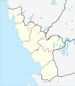
276:counties reaches the bay between
437:
418:
95:
88:
65:
58:
44:
204:
196:
188:
1:
117:
449:. You can help Knowledge by
501:Landforms of Halland County
527:
432:
230:not a well-defined measure
506:Landforms of Skåne County
227:
52:
43:
26:
313:Laholm Bay suffers from
209:50 km (31 mi)
511:Sweden geography stubs
397:Cite journal requires
246:
201:20 m (66 ft)
28:
427:at Wikimedia Commons
280:and Hemmeslövstrand.
268:The border between
156: /
79:Show map of Halland
249:) is a bay of the
109:Show map of Sweden
458:
457:
423:Media related to
293:Skummeslövsstrand
257:in the north and
236:
235:
518:
479:
472:
465:
441:
434:
422:
407:
406:
400:
395:
393:
385:
383:
381:
370:
364:
363:
361:
359:
344:
308:long sandy beach
228:Shore length is
171:
170:
168:
167:
166:
161:
157:
154:
153:
152:
149:
139:
110:
99:
98:
92:
80:
69:
68:
62:
48:
39:
31:
19:
526:
525:
521:
520:
519:
517:
516:
515:
486:
485:
484:
483:
430:
416:
411:
410:
396:
386:
379:
377:
372:
371:
367:
357:
355:
348:"Laholmsbukten"
346:
345:
336:
331:
164:
162:
160:56.53°N 12.78°E
158:
155:
150:
147:
145:
143:
142:
114:
113:
112:
111:
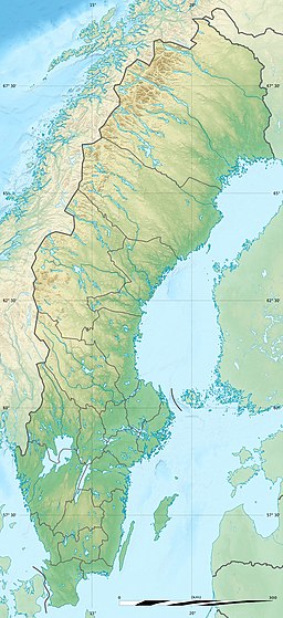
108:
107:
106:
105:
104:
100:
83:
82:
81:
78:
77:
76:
75:
74:
70:
33:
17:
12:
11:
5:
524:
522:
514:
513:
508:
503:
498:
496:Bays of Sweden
488:
487:
482:
481:
474:
467:
459:
456:
455:
442:
415:
414:External links
412:
409:
408:
399:|journal=
365:
333:
332:
330:
327:
315:eutrophication
234:
233:
225:
224:
219:
215:
214:
211:
210:
207:
203:
202:
199:
195:
194:
191:
187:
186:
183:
182:
177:
173:
172:
140:
134:
133:
123:Halland County
120:
116:
115:
102:
101:
94:
93:
87:
86:
85:
84:
72:
71:
64:
63:
57:
56:
55:
54:
53:
50:
49:
41:
40:
24:
23:
15:
13:
10:
9:
6:
4:
3:
2:
523:
512:
509:
507:
504:
502:
499:
497:
494:
493:
491:
480:
475:
473:
468:
466:
461:
460:
454:
452:
448:
443:
440:
436:
431:
428:
426:
425:Laholmsbukten
421:
413:
404:
391:
375:
369:
366:
353:
349:
343:
341:
339:
335:
328:
326:
324:
320:
316:
311:
309:
304:
302:
298:
294:
290:
285:
281:
279:
275:
271:
266:
264:
260:
256:
252:
248:
247:Laholmsbukten
244:
240:
231:
226:
223:
220:
216:
212:
208:
200:
198:Average depth
192:
184:
181:
178:
174:
169:
141:
135:
132:
128:
124:
121:
91:
61:
51:
47:
42:
37:
30:
29:Laholmsbukten
25:
20:
451:expanding it
444:
429:
417:
390:cite journal
378:. Retrieved
368:
356:. Retrieved
351:
319:algal blooms
317:and related
312:
305:
297:Mellbystrand
286:
282:
267:
238:
237:
206:Shore length
190:Surface area
176:Part of
165:56.53; 12.78
127:Skåne County
263:Skälder Bay
259:Hovs Hallar
218:Settlements
163: /
138:Coordinates
490:Categories
329:References
253:, between
239:Laholm Bay
103:Laholm Bay
73:Laholm Bay
22:Laholm Bay
352:www.ne.se
323:nitrogen
255:Tylösand
251:Kattegat
222:Halmstad
180:Kattegat
119:Location
380:18 June
358:16 June
270:Halland
243:Swedish
151:12°47′E
148:56°32′N
36:Swedish
301:Laholm
295:, and
289:Båstad
278:Båstad
131:Sweden
32:
274:Skåne
447:stub
403:help
382:2021
360:2016
306:The
272:and
125:and
492::
394::
392:}}
388:{{
350:.
337:^
265:.
245::
129:,
478:e
471:t
464:v
453:.
405:)
401:(
384:.
362:.
241:(
232:.
38:)
34:(
Text is available under the Creative Commons Attribution-ShareAlike License. Additional terms may apply.