275:
267:
262:
brought to Land's End camp completed 9.2 miles of road. They were paid a dollar a day for their work. Ranging in age from thirty-three to fifty-five, the veterans were hailed as "a remarkable group of men, skilled in almost every imaginable trade." They lived in army tents roughly eleven miles below the mesa rim while clearing the brush for the road. The toughest part of the Land's Ends Road, from the Wild Road Picnic Area to the rim, was completed over the next two summers by Civil
Service machine operators and a few civilian workers hired by the United States Forest Service. "Built the whole road," said the project engineer, "blasting and all, without injuries."
48:
877:
65:
90:
256:
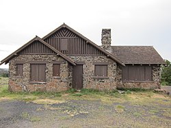
throughout the national parks and forests. It is marked by simplicity and craftsmanship, appearing to grow out of the earth rather than intrude upon it. Basalt stones were selected from the mesa and carefully fitted together to form the walls and terrace. Wood shingles were hand- sawn. The original, handcrafted woodwork can still be found inside. Most of the WPA workers who toiled here during the Great
Depression are unknown, the observatory remains their legacy.
888:
97:
72:
370:
261:
Land's End Road was once known as the
Veterans' Road. When the Great Depression left many World War I veterans unemployed, President Roosevelt responded by opening the already created Civilian Conservation Corps (CCC) to include them. Thus, between June 1933 and May 1934, the 200 veterans who were
255:
You have reached Land's End
Observatory on Colorado's highest mesa, the Grand Mesa, 10,500 feet above sea level. Built in 1936-37 by the United States Forest Service and the Works Progress Administration (WPA), the observatory reflects the rustic style of architecture found in public buildings
766:
912:
861:
797:
781:
771:
942:
856:
802:
443:
823:
725:
756:
690:
655:
730:
635:
595:
420:
695:
685:
680:
660:
776:
610:
525:
645:
640:
515:
917:
735:
700:
605:
580:
720:
670:
650:
625:
615:
600:
590:
575:
555:
530:
520:
510:
740:
715:
620:
560:
540:
535:
505:
495:
675:
630:
570:
545:
500:
807:
705:
585:
550:
922:
761:
710:
665:
565:
248:
A large viewing area outside the building provides a panoramic view of western
Colorado and eastern Utah. As of 2022, the observatory building itself is closed and boarded up.
473:
458:
937:
413:
489:
932:
891:
406:
274:
881:
129:
89:
64:
947:
927:
453:
266:
429:
301:
219:
34:
374:
844:
238:
234:
242:
849:
828:
227:
223:
463:
222:
via Land's End Road, which is about half paved and half gravel. The observatory is about 10 miles west of
468:
448:
306:
47:
117:
342:
393:
387:
398:
320:
191:
906:
862:
University and college buildings listed on the
National Register of Historic Places
226:. Land's End Road descends as an all-gravel road from the observatory down to
211:
144:
131:
913:
Government buildings on the
National Register of Historic Places in Colorado
369:
270:
Land's End Road descending from Land's End
Observatory to U. S. Route 50.
215:
857:
List of jails and prisons on the
National Register of Historic Places
230:, and the observatory can be accessed from that direction as well.
273:
265:
296:
402:
381:
278:
Land's End
Observatory viewing area, looking towards the north.
943:
National Register of Historic Places in Mesa County, Colorado
341:
Office of Archaeology and Historic Preservation (June 2006).
180:
Late 19th And Early 20th Century American Movements, rustic
251:
From the U. S. Forest Service sign outside the building:
321:"Grand Mesa, Uncompahgre and Gunnison National Forests"
388:
National Register of Historic Places Registration Form
837:
816:
790:
749:
482:
459:
History of the National Register of Historic Places
436:
197:
184:
176:
168:
160:
123:
113:
96:
71:
918:Buildings and structures in Mesa County, Colorado
490:List of U.S. National Historic Landmarks by state
882:National Register of Historic Places portal
414:
8:
923:Tourist attractions in Mesa County, Colorado
52:Land's End Observatory, West side, July 2012
394:National Register of Historic Places Photos
241:in 1936-37, with some assistance from two
421:
407:
399:
46:
938:Works Progress Administration in Colorado
430:U.S. National Register of Historic Places
384:- official site with visiting information
35:U.S. National Register of Historic Places
172:US Forest Service, et al; Anderson, Ivan
933:Civilian Conservation Corps in Colorado
288:
297:"National Register Information System"
210:is a ranger observatory on the rim of
18:
7:
302:National Register of Historic Places
220:Grand Mesa Scenic and Historic Byway
845:National Historic Preservation Act
390:- extensive detail on the building
14:
233:The observatory was built by the
887:
886:
875:
368:
343:"New Deal in Colorado 1933-1942"
95:
88:
70:
63:
948:1937 establishments in Colorado
928:Rustic architecture in Colorado
798:Federated States of Micronesia
444:Architectural style categories
186:
1:
348:. Colorado Historical Society
239:Works Progress Administration
104:Show map of the United States
235:United States Forest Service
218:. It is accessible from the
16:United States historic place
243:Civilian Conservation Corps
964:
850:Historic Preservation Fund
829:American Legation, Morocco
382:Grand Mesa National Forest
870:
791:Lists by associated state
323:. National Forest Service
224:Colorado State Highway 65
185:NRHP reference
57:
45:
41:
32:
25:
21:
772:Northern Mariana Islands
177:Architectural style
164:3.7 acres (1.5 ha)
767:Minor Outlying Islands
750:Lists by insular areas
464:Keeper of the Register
375:Land's End Observatory
279:
271:
264:
258:
208:Land's End Observatory
145:39.02500°N 108.22361°W
27:Land's End Observatory
469:National Park Service
449:Contributing property
377:at Wikimedia Commons
307:National Park Service
277:
269:
259:
253:
824:District of Columbia
150:39.02500; -108.22361
118:Whitewater, Colorado
79:Show map of Colorado
141: /
280:
272:
245:(CCC) side camps.
900:
899:
454:Historic district
373:Media related to
309:. March 13, 2009.
205:
204:
201:February 28, 1997
955:
890:
889:
880:
879:
878:
803:Marshall Islands
423:
416:
409:
400:
372:
357:
356:
354:
353:
347:
338:
332:
331:
329:
328:
317:
311:
310:
293:
188:
156:
155:
153:
152:
151:
146:
142:
139:
138:
137:
134:
105:
99:
98:
92:
80:
74:
73:
67:
50:
19:
963:
962:
958:
957:
956:
954:
953:
952:
903:
902:
901:
896:
876:
874:
866:
833:
812:
786:
745:
478:
432:
427:
366:
361:
360:
351:
349:
345:
340:
339:
335:
326:
324:
319:
318:
314:
295:
294:
290:
285:
149:
147:
143:
140:
135:
132:
130:
128:
127:
109:
108:
107:
106:
103:
102:
101:
100:
83:
82:
81:
78:
77:
76:
75:
53:
37:
28:
17:
12:
11:
5:
961:
959:
951:
950:
945:
940:
935:
930:
925:
920:
915:
905:
904:
898:
897:
895:
894:
884:
871:
868:
867:
865:
864:
859:
854:
853:
852:
841:
839:
835:
834:
832:
831:
826:
820:
818:
814:
813:
811:
810:
805:
800:
794:
792:
788:
787:
785:
784:
782:Virgin Islands
779:
774:
769:
764:
759:
757:American Samoa
753:
751:
747:
746:
744:
743:
738:
733:
728:
723:
718:
713:
708:
703:
698:
693:
691:South Carolina
688:
683:
678:
673:
668:
663:
658:
656:North Carolina
653:
648:
643:
638:
633:
628:
623:
618:
613:
608:
603:
598:
593:
588:
583:
578:
573:
568:
563:
558:
553:
548:
543:
538:
533:
528:
523:
518:
513:
508:
503:
498:
493:
486:
484:
483:Lists by state
480:
479:
477:
476:
474:Property types
471:
466:
461:
456:
451:
446:
440:
438:
434:
433:
428:
426:
425:
418:
411:
403:
397:
396:
391:
385:
365:
364:External links
362:
359:
358:
333:
312:
287:
286:
284:
281:
203:
202:
199:
195:
194:
189:
182:
181:
178:
174:
173:
170:
166:
165:
162:
158:
157:
125:
121:
120:
115:
111:
110:
94:
93:
87:
86:
85:
84:
69:
68:
62:
61:
60:
59:
58:
55:
54:
51:
43:
42:
39:
38:
33:
30:
29:
26:
23:
22:
15:
13:
10:
9:
6:
4:
3:
2:
960:
949:
946:
944:
941:
939:
936:
934:
931:
929:
926:
924:
921:
919:
916:
914:
911:
910:
908:
893:
885:
883:
873:
872:
869:
863:
860:
858:
855:
851:
848:
847:
846:
843:
842:
840:
836:
830:
827:
825:
822:
821:
819:
815:
809:
806:
804:
801:
799:
796:
795:
793:
789:
783:
780:
778:
775:
773:
770:
768:
765:
763:
760:
758:
755:
754:
752:
748:
742:
739:
737:
734:
732:
731:West Virginia
729:
727:
724:
722:
719:
717:
714:
712:
709:
707:
704:
702:
699:
697:
694:
692:
689:
687:
684:
682:
679:
677:
674:
672:
669:
667:
664:
662:
659:
657:
654:
652:
649:
647:
644:
642:
639:
637:
636:New Hampshire
634:
632:
629:
627:
624:
622:
619:
617:
614:
612:
609:
607:
604:
602:
599:
597:
596:Massachusetts
594:
592:
589:
587:
584:
582:
579:
577:
574:
572:
569:
567:
564:
562:
559:
557:
554:
552:
549:
547:
544:
542:
539:
537:
534:
532:
529:
527:
524:
522:
519:
517:
514:
512:
509:
507:
504:
502:
499:
497:
494:
491:
488:
487:
485:
481:
475:
472:
470:
467:
465:
462:
460:
457:
455:
452:
450:
447:
445:
442:
441:
439:
435:
431:
424:
419:
417:
412:
410:
405:
404:
401:
395:
392:
389:
386:
383:
380:
379:
378:
376:
371:
363:
344:
337:
334:
322:
316:
313:
308:
304:
303:
298:
292:
289:
282:
276:
268:
263:
257:
252:
249:
246:
244:
240:
236:
231:
229:
228:U.S. Route 50
225:
221:
217:
213:
209:
200:
198:Added to NRHP
196:
193:
190:
183:
179:
175:
171:
167:
163:
159:
154:
126:
122:
119:
116:
112:
91:
66:
56:
49:
44:
40:
36:
31:
24:
20:
696:South Dakota
686:Rhode Island
681:Pennsylvania
661:North Dakota
367:
350:. Retrieved
336:
325:. Retrieved
315:
300:
291:
260:
254:
250:
247:
232:
207:
206:
114:Nearest city
817:Other areas
777:Puerto Rico
611:Mississippi
526:Connecticut
148: /
136:108°13′25″W
124:Coordinates
907:Categories
726:Washington
646:New Mexico
641:New Jersey
516:California
352:2007-08-23
327:2007-08-23
283:References
212:Grand Mesa
736:Wisconsin
701:Tennessee
606:Minnesota
581:Louisiana
169:Architect
133:39°1′30″N
892:Category
721:Virginia
671:Oklahoma
651:New York
626:Nebraska
616:Missouri
601:Michigan
591:Maryland
576:Kentucky
556:Illinois
531:Delaware
521:Colorado
511:Arkansas
237:and the
216:Colorado
192:97000124
838:Related
741:Wyoming
716:Vermont
621:Montana
561:Indiana
541:Georgia
536:Florida
506:Arizona
496:Alabama
676:Oregon
631:Nevada
571:Kansas
546:Hawaii
501:Alaska
437:Topics
808:Palau
706:Texas
586:Maine
551:Idaho
346:(PDF)
762:Guam
711:Utah
666:Ohio
566:Iowa
161:Area
214:in
187:No.
909::
305:.
299:.
492::
422:e
415:t
408:v
355:.
330:.
Text is available under the Creative Commons Attribution-ShareAlike License. Additional terms may apply.