140:
133:
274:
312:, who was on a solo climb (the expedition started on 5 October) via the South Face, had an accident during his descent. Sources report that he became stuck on the mountain at an approximate height of 6300 meters with a broken leg (other sources also report broken ribs and damaged spine). His only contact with the base camp staff via a
29:
329:
resulted in a landslide on
Langtang Lirung. In Langtang village, directly in the path of the landslide, 243 people died. It took the villagers two year to rebuild the houses that were destroyed by the landslide in the Langtang Lirung. The route to the mountain was only opened for after 2017, when the
251:
Himal forms the western portion of a complex of mountains which also includes the Jugal Himal, home of
Shishapangma. This complex lies between the Sun Kosi valley on the east and the Trisuli Gandaki valley on the west. Langtang Lirung lies near the Trisuli Gandaki, and north of the Langtang Khola. At
264:
Though not high by the standards of major
Himalayan peaks, Langtang Lirung is notable for its large vertical relief above local terrain. For example, it rises 5,500 metres (18,000 ft) above the Trisuli Gandaki to the west in only 16 kilometres (9.9 mi). It has a large south face which long
305:, there have been 14 ascents of Langtang Lirung (in 1978, 1980, 1981, 1982, 1986, 1988, 1989, 1992, 1994, and 1995), mostly by the Southeast or Southwest Ridge routes; and 13 unsuccessful attempts on the peak (these may be underestimates).
316:
was made on the day of the accident, and he appeared to be in a critical condition. The rescue party found his body on 14 November at the height of 5,600 metres (18,400 ft). Presumably, he died on 9 or 10 November.
605:
610:
89:
587:
288:
On
October 24,1978 Seishi Wada and Pemba Tsering Sherpa from a Japanese expedition made the first ascent of the mountain via the East Ridge.
473:
499:
339:
553:
132:
285:
and P. Lloyd in 1949. Attempts were made to climb the peak via the East Ridge in the 1960s, but none got close to the summit.
434:
408:
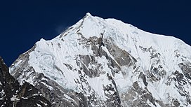
82:
582:
326:
52:
537:
60:
298:
ascent. On 3 January 1988 Mikołaj Czyżewski, Kazimierz Kiszka and Adam
Potoczek stood at the summit.
75:
477:
70:
549:
459:
420:
233:
514:
313:
563:
309:
176:
599:
576:
385:
236:
205:
195:
364:
438:
435:"Langtang Lirung rescue update: Tomaz Humar missing, Swiss rescuers stuck in BC"
282:
365:"High Asia II: Himalaya of Nepal, Bhutan, Sikkim and adjoining region of Tibet"
273:
253:
104:
91:
229:
183:
248:
222:
165:
239:. The List of the world's highest 100 mountains puts it at number 99.
295:
291:
44:
558:
302:
500:"The fate of Langtang village two years after the Nepal earthquake"
272:
226:
169:
28:
546:
High Asia: An
Illustrated History of the 7000 Metre Peaks
409:
Historia polskiego wspinania. Himalaje cz.III (lata 1984-88)
577:
A list of mountains ranked by local relief and steepness
421:"Tomaz Humar Stuck on Langtang Lirung with broken leg??"
200:
October 24, 1978 by Seishi Wada and Pemba
Tsering Sherpa
535:H. Adams Carter, "Classification of the Himalaya,"
204:
194:
189:
175:
161:
120:
81:
69:
59:
43:
38:
21:
8:
583:Pictures of Langtang Lirung with Cheng Liru
330:villagers build up a completely new path.
359:
357:
355:
308:On 9 November 2009, Slovenian mountaineer
18:
579:showing Langtang Lirung as the world #20.
327:massive 7.8-magnitude earthquake in Nepal
476:. Topnews.in. 2007-08-19. Archived from
460:"Tomaz Humar Missing on Langtang Lirung"
351:
139:
474:"Slovenian climber dies in Himalayas"
7:
588:Tomaž Humar dies in Langtang Lirung
252:a distance of 4km towards the east,
606:Seven-thousanders of the Himalayas
437:. MountEverest.net. Archived from
340:List of highest mountains on Earth
225:Himal, which is a subrange of the
14:
611:Mountains of the Bagmati Province
566:(Corrected versions of SRTM data)
498:Horrell, Mark (April 26, 2017).
138:
131:
27:
281:The peak was reconnoitered by
16:Highest peak of Langtang Himal
1:
265:resisted climbing attempts.
49:7,234 m (23,734 ft)
515:"Langtang Lirung after 2015"
65:1,534 m (5,033 ft)
221:is the highest peak of the
627:
564:DEM files for the Himalaya
390:nepalhimalpeakprofile.org
125:
26:
538:American Alpine Journal
33:Langtang Lirung in 2020
462:. www.everestnews.com.
423:. www.everestnews.com.
278:
276:
105:28.25750°N 85.51583°E
513:Himalayan, Masters.
325:On 25 April 2015, a
232:, southwest of the
212:rock/snow/ice climb
101: /
279:
110:28.25750; 85.51583
39:Highest point
386:"Langtang Lirung"
321:Avalanche in 2015
301:According to the
216:
215:
55:
618:
523:
522:
510:
504:
503:
495:
489:
488:
486:
485:
470:
464:
463:
456:
450:
449:
447:
446:
431:
425:
424:
417:
411:
406:
400:
399:
397:
396:
382:
376:
375:
373:
372:
361:
269:Climbing history
234:Eight-thousander
208:
179:
142:
141:
135:
116:
115:
113:
112:
111:
106:
102:
99:
98:
97:
94:
51:
31:
19:
626:
625:
621:
620:
619:
617:
616:
615:
596:
595:
593:
573:
559:Himalayan Index
532:
527:
526:
519:langtang Lirung
512:
511:
507:
497:
496:
492:
483:
481:
472:
471:
467:
458:
457:
453:
444:
442:
433:
432:
428:
419:
418:
414:
407:
403:
394:
392:
384:
383:
379:
370:
368:
363:
362:
353:
348:
336:
323:
314:satellite phone
303:Himalayan Index
294:made the first
277:Langtang Lirung
271:
262:
245:
219:Langtang Lirung
206:
177:
157:
156:
155:
154:
153:
150:
149:
148:
147:
146:Langtang Lirung
143:
109:
107:
103:
100:
95:
92:
90:
88:
87:
50:
34:
22:Langtang Lirung
17:
12:
11:
5:
624:
622:
614:
613:
608:
598:
597:
591:
590:
585:
580:
572:
571:External links
569:
568:
567:
561:
556:
542:
531:
528:
525:
524:
505:
490:
465:
451:
426:
412:
401:
377:
367:. Peaklist.org
350:
349:
347:
344:
343:
342:
335:
332:
322:
319:
270:
267:
261:
258:
244:
241:
214:
213:
210:
202:
201:
198:
192:
191:
187:
186:
184:Langtang Himal
181:
173:
172:
163:
159:
158:
151:
145:
144:
137:
136:
130:
129:
128:
127:
126:
123:
122:
118:
117:
85:
79:
78:
73:
67:
66:
63:
57:
56:
47:
41:
40:
36:
35:
32:
24:
23:
15:
13:
10:
9:
6:
4:
3:
2:
623:
612:
609:
607:
604:
603:
601:
594:
589:
586:
584:
581:
578:
575:
574:
570:
565:
562:
560:
557:
555:
554:0-89886-238-8
551:
547:
543:
540:
539:
534:
533:
529:
520:
516:
509:
506:
501:
494:
491:
480:on 2012-03-09
479:
475:
469:
466:
461:
455:
452:
441:on 2017-12-09
440:
436:
430:
427:
422:
416:
413:
410:
405:
402:
391:
387:
381:
378:
366:
360:
358:
356:
352:
345:
341:
338:
337:
333:
331:
328:
320:
318:
315:
311:
306:
304:
299:
297:
293:
289:
286:
284:
275:
268:
266:
259:
257:
255:
250:
242:
240:
238:
235:
231:
228:
224:
220:
211:
209:
207:Easiest route
203:
199:
197:
193:
188:
185:
182:
180:
174:
171:
167:
164:
160:
134:
124:
119:
114:
86:
84:
80:
77:
74:
72:
68:
64:
62:
58:
54:
48:
46:
42:
37:
30:
25:
20:
592:
545:
544:Jill Neate,
536:
518:
508:
493:
482:. Retrieved
478:the original
468:
454:
443:. Retrieved
439:the original
429:
415:
404:
393:. Retrieved
389:
380:
369:. Retrieved
324:
307:
300:
290:
287:
283:H. W. Tilman
280:
263:
256:is located.
246:
237:Shishapangma
218:
217:
196:First ascent
178:Parent range
310:Tomaž Humar
108: /
83:Coordinates
53:Ranked 99th
600:Categories
484:2009-11-14
445:2009-11-14
395:2024-07-10
371:2014-05-30
346:References
254:Tsangbu Ri
96:85°30′57″E
93:28°15′27″N
61:Prominence
230:Himalayas
121:Geography
45:Elevation
334:See also
260:Features
249:Langtang
243:Location
227:Nepalese
223:Langtang
190:Climbing
166:Langtang
162:Location
530:Sources
71:Listing
552:
296:winter
541:1985.
292:Poles
170:Nepal
152:Nepal
76:Ultra
550:ISBN
247:The
602::
548:,
517:.
388:.
354:^
168:,
521:.
502:.
487:.
448:.
398:.
374:.
Text is available under the Creative Commons Attribution-ShareAlike License. Additional terms may apply.